1.1 ON THE RELATION BETWEEN SURFACE SPATIAL HETEROGENEITY AND CLIMATE PREDICTION: INSIGHTS FROM THE INTEGRATION OF FINE RESOLUTION SATELLITE LAND INFORMATION INTO MESOSCALE CLIMATE MODELS *
#
Jimmy O. Adegoke and Kevin P. Gallo University of Missouri-Kansas City, Missouri # NOAA/NESDIS, Sioux Falls, South Dakota 1. INTRODUCTION The modeling of atmospheric systems across all scales (global to catchment) has attracted a lot of attention within the climate science community due to concerns about climate change and its potential impacts. Many of the widely used atmospheric models include a surface module through which land surface boundary conditions based on land cover, land use and elevation data are introduced into the model simulations (Lee et al. 1993; Pielke et al. 1998; Rozoff et al. 2003). These land surface data sets are grid based and can be constructed from existing land use/land cover (LU/LC) database such as the Olson Global Ecosystem (OGE) database or derived directly from satellite sources. By integrating these data sets into atmospheric modeling systems, significant advances are being made in delineating the role of land surface structure and heterogeneity on global and regional climate. Of particular interest is the impact of land use and landscape changes on the partitioning of surface turbulent heat fluxes, and the boundary layer structure.
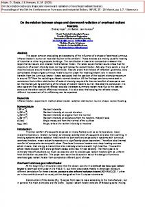
In Adegoke et al. (2003a), we constructed land cover scenarios representing early 1900s and early 1990s for the Baltimore-Washington DC area for use as lower boundary conditions in simulations with RAMS (Figure 1). The 1990s land cover scenario was developed from full-resolution LANDSAT imagery (Figure 1b).
(a)
2. CASE STUDIES In several recent studies we used the Colorado State University Regional Atmospheric Modeling System (RAMS) to perform sensitivity simulations of regional and local climate to both the specification of and changes in vegetation distribution. Two interconnected issues were investigated: the direct influence of surface representation in RAMS using high resolution satellite products; and the feedbacks and interactions between the land surface and various physical components that are triggered by the land surface representation in the model.
* Corresponding author address: Jimmy O. Adegoke, University of Missouri-Kansas City, Dept. of Geosciences, Kansas City MO 641102499; e-mail:
[email protected]
(b) Figure 1: 1900 (a) and 1992 LANDSAT-derived (b) LU/LC scenarios used as lower boundary conditions in the Baltimore-Washington DC modeling experiments.
The Baltimore-Washington DC simulations were designed to diagnose the extent and spatial variability of anomalies in surface heat, moisture, and momentum and their effects on local and regional climate. The results of that study indicated that mid-summer near-ground temperature over the Washington DC- Baltimore urban core might be warmer by as much as 4.8 oC under current conditions compared to the early 1990s. The domain average temperature difference between the two land cover scenarios was 3.2oC and total convective precipitation during the month long simulation averaged almost 125 mm more under the current LU/LC conditions (Figure 2). The urban land cover induced surface warming was accompanied by a 36% increase in the surface sensible heat flux and a significant reduction (28%) in surface latent heat flux.
(a)
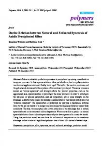
(b) Figure 3. LANDSAT–derived irrigated area a) and Kuchler potential vegetation b) datasets used for RAMS simulations of the Impact of irrigation in Nebraska (from Adegoke et al. 2003b) .
Figure 2. Difference in convective precipitation in the Washington D.C. area for July 2000 between model simulations using current and pre-1900 LU/LC (From Adegoke et al. 2003a). Similarly, in Adegoke et al (2003b) we used LANDSAT-derived land cover depicting contemporary irrigation in Nebraska (Fig. 3a) and the natural (i.e., pre-European settlement) land cover from the Kuchler vegetation dataset (Fig. 3b) to investigate the impact of irrigation on surface energy budget in the Unites States High Plains.
Over a mid-summer two-week period during which several simulations were conducted using RAMS, domain area-averaged difference between the control (simulated irrigation included) and dry runs (simulated irrigation not included) indicated a 36% increase in the surface latent heat flux. At 500 meters above the ground, a 28% increase in water o vapor flux and a 2.6 C elevation in dew point temperature were also observed. Surface sensible heat flux of the control-run was 15% less and o near-ground temperature was 1.2 C cooler compared to the dry-run. The cumulative effect of the increase in water vapor and dew point temperature, and the decrease in temperature is reflected in an observed increase in the controlrun theta-e within the boundary layer. These results suggest that the structure of the CBL and the partitioning of the available surface energy in this region may have been significantly altered by human modifications, with potential implications for short- to medium range weather prediction, especially the prediction of cumulus convective rainfall in the U.S. High Plains.
3. REFERENCES Adegoke, J. O., K. P. Gallo, R. A. Pielke Sr., L. Steyaert, and W. P. Kustas, 2003a: Modeling the influence of urban land cover conversions on the lower atmosphere in the Baltimore Washington- DC area. (In Preparation for submission to Journal of Applied Meteorology). __________, R. A. Pielke Sr., J. Eastman, R. Mahmood, and K. G. Hubbard, 2003b: A Regional Atmospheric Model study of the impact of irrigation on midsummer surface energy budget in the U.S. High Plains. Monthly Weather Review 131(3), 556-564. Lee, T. J., R. A. Pielke Sr., T. G. F. Kittel, and J. F. Weaver, 1993: Atmospheric modeling and its spatial representation of land surface characteristics. In Environmental Modeling with GIS Eds: M. F. Goodchild, B.O. Parks, and L. T. Steyaert Oxford University Press, 100122. Pielke Sr. R. A., R. Avissar, M. Raupach, H. Dolman, X. Zeng, and S. Denning, 1998: Interactions between the atmosphere and terrestrial ecosystems: Influence on weather and climate. Global Change Biology, 4, 461-475. Rozoff, C. M., W. R. Cotton, and J. O. Adegoke, 2003: Simulation of St. Louis, MO landuse Impacts on thunderstorms. Journal of Applied Meteorology. 42(6) 716–738.