Self-archived version of an article published 2008 in Water, Air, and Soil Pollution 187: 119-147. Minor details may differ between this version and the published article. DOI: 10.1007/s11270-007-9502-1 URL: http://www.springerlink.com/content/k778852373n8u7t5/ Copyright: The Authors. For further copyright issues, please contact the journal.
---------------------------------------------------------------------------------------------------------------A Dynamic Mass-balance Model for Phosphorus in Lakes with a Focus on Criteria for Applicability and Boundary Conditions Lars Håkanson1 and Andreas C. Bryhn1 (1) Department of Earth Sciences, Uppsala University, Villavägen 16, 752 36 Uppsala, Sweden Corresponding Author: Lars Håkanson Email:
[email protected] Abstract This paper presents an improved version of a general, process-based mass-balance model (LakeMab/LEEDS) for phosphorus in entire lakes (the ecosystem scale). The focus in this work is set on the boundary conditions, i.e., the domain of the model, and critical tests to reveal those boundary conditions using data from a wide limnological range. The basic structure of the model, and many key equations have been presented and motivated before, but this work presents several new developments. The LakeMab-model is based on ordinary differential equations regulating inflow, outflow and internal fluxes and the temporal resolution is one month to reflect seasonal variations. The model consists of four compartments: surface water, deep water, sediment on accumulation areas and sediment on areas of erosion and transportation. The separation between the surface-water layer and the deep-water layer is not done from water temperature data, but from sedimentological criteria (from the theoretical wave base, which regulates where wind/wave-induced resuspension of fine sediments occurs). There are algorithms for processes regulating internal fluxes and internal loading, e.g., sedimentation, resuspension, diffusion, mixing and burial. Critical model tests were made using data from 41 lakes of very different character and the results show that the model could predict mean monthly TP-concentrations in water very well (generally within the uncertainty bands given by the empirical data). The model is even easier to apply than the well-known OECD and Vollenweider models due to more easily accessed driving variables. Keywords Eutrophication - Mass-balance model - Phosphorus - Lakes - Processes Fluxes - Sedimentation - Resuspension - Mixing - Suspended particulate matter 1 Background and Aim Phosphorus abatement has substantially improved the water quality in many anthropogenically eutrophicated lakes (Sas 1989; Jeppesen et al. 2005). Models for predicting lake response from phosphorus reductions have thus far been rather imprecise and results from abatement programs have sometimes been disappointingly modest (Sas 1989). Phosphorus is since long recognised as a crucial limiting nutrient for lake primary production (Schindler 1977, 1978; Bierman 1980; Chapra 1980; Boynton et al. 1982; Wetzel 1983;
Persson and Jansson 1988; Boers et al. 1993). The literature on phosphorus in lakes is extensive. The famous Vollenweider model (Vollenweider 1968, 1976; and later versions, e.g., OECD 1982), and the analysis behind this modelling, constitutes a fundamental base for water management (Wetzel 2001; Håkanson and Boulion 2002). Lake modelling has gone through great changes recently with respect to predictive power. As a consequence of the Chernobyl nuclear accident, the pulse of radionuclides that subsequently passed along European ecosystem pathways has revealed, and made it possible to quantify, important transport routes (Håkanson 2000). Many algorithms that quantify these fluxes are valid not just for radionuclides, but for most types of contaminants, e.g., for metals, nutrients and organics in most types of aquatic environments (rivers, lakes and coastal areas) and they form the basis for the mass-balance model for phosphorus in lakes presented in this work. In aquatic modelling there exist different kinds of models, e.g., hydraulic models driven by online meteorological data (winds, temperature and precipitation). Such models cannot generally be used for predictions over longer periods than 2 to 3 days since it is not possible to make reliable weather forecasts for longer periods that that. These models may be excellent tools in science and may give descriptive power rather than long-term predictive power. There are also different types of ecosystem-oriented modelling approaches for nutrients and toxins (see, e.g., Vollenweider 1968; Chapra 1980; OECD 1982; Monte et al. 2005). However, there are major differences between the model discussed here and other models related to differences in target variables (from conditions at individual sites to mean values over larger areas), modelling scales (daily to annual predictions), modelling structures (from using empirical/regression models to the use of ordinary or partial differential equations) and driving variables (whether accessed from standard monitoring programs, climatological measurements or specific studies). To make meaningful model comparisons is not a simple matter, and this is not the focus here, although we will make brief model comparisons between the results from this model (LakeMab/LEEDS; see previous development stages presented by Håkanson and Boulion 2002; Malmaeus and Håkanson 2004; Dahl et al. 2006) and two well-known models in lake management, which are also driven by easily accessed driving variables, the Vollenweider model and the OECD model. The aim of this work is to improve a model that is process-based in the sense that it should handle all important fluxes regulating the concentration of the target variable (total phosphorus) in lakes in general. As far as we know, there exist no nutrient mass-balance models of the type presented here (except from our group at Uppsala University) accounting for, e.g., tributary inflow, surface and deep-water mixing, sedimentation of particulate P, resuspension, diffusion and outflow in a general manner designed to achieve practical utility and monthly variations in most/all types of lakes. Since different stages of this mass-balance modelling have been presented by several members of our team, the aim of this work is not to repeat those stages or the details in this ongoing development, but rather to focus on the new aspects related to the boundary conditions of the model. In this paper, we will first briefly present the studied lakes and the utilized data. In the Appendix, we will go through the more detailed set-up of the modelling. We will demonstrate how well the model works when tested for the studied lakes in terms of predicting the target variable (the TP concentration in water). As stressed, a very important part of this work has been to try to find and define the model domain, i.e., where the model does and does not
apply. Finding these limits has meant that the model looks bigger but defining the model domain is very important for the practical use and predictive power of the model. 2 Data and Methods 2.1 Studied Lakes and Utilized Data In this work, data from 41 lakes from the northern hemisphere are used. Tables 1 and 2 give a compilation of data on latitude (from 28.6 to 68.5°N), lake area (from 0.014 to 3,555 km2), maximum depth (from 4.5 to 449 m), mean depth (from 1.2 to 177 m), annual precipitation (from 600 to 1,900 mm/year), drainage area (from 0.11 to 44,200 km2), altitude (11 to 850 m.a.s.l.), empirical TP-concentrations in water (from 4 to 1,100 μg/l). These lakes cover a very wide domain in terms of size and form as well as geographical distribution and trophic status. The lakes were selected based on the following two criteria: (1) They had been thoroughly studied and (2) there were either lake-typical data available for steady-state conditions regarding TP-concentrations (as expressed in Table 2), or long time series with data covering a large part of the history that preceded the eutrophication period. For lakes with long time series available, median TP values were calculated (see Table 2) and used in the comparisons between LakeMab, the Vollenweider model and the OECD model. Whenever available, long time series covering several years were also used to test modelled data from LakeMab against empirical data. Some of these results are presented here and others may be presented in future works. The literature references given in Table 3 provide more information on the lakes and the reliability and variability of the data. Table 1 Data for the 41 studied lakes (more data are given in Table 2)
Referencesa Drainage D m Area Precipitation Altitude (see area max (m.a.s.l.) (m) (km2) (mm/year) (m) Table 3) (km2)
D
Lake name
Latitude (°N)
Washington
47.6
65.2 32.9 87.6
890
1,500
20
a
Blue chalk
45.2
23
8.5
0.52
1,034
1.06
320
b
Chub
45.2
27
8.9
0.34
1,034
2.72
320
b
Crosson
45.1
25
9.2
0.57
1,034
5.22
320
b
Dickie
45.2
12
5
0.94
1,034
4.06
320
b
Harp
45.4
37.5 13.3 0.71
1,034
4.71
320
b
Plastic
45.2
16.3 7.9
0.32
1,034
0.96
320
b
Red chalk
45.2
38
14.2 0.57
1,034
5.32
320
b, c
Mendota
43.0
23
12.3 39.4
768
604
850
d
Peipsi
58.5
15.3 7.1
3,555 600
44,200
29.5
e
Mjøsa
60.7
449 153
365
740
17,369
122
f
Mirror
43.9
11
0.15
1,311
1.03
213
g
Vättern
58.3
128 39.8 1,856 600
4,500
88
h
S 57.0 Bergundasjön
5.4 2.4
4.3
750
45.1
160
j
Wahnbachtal50.8 sperre
42
1.3
811
54
130
k
5.8
16
Referencesa Drainage D m Area Precipitation Altitude area (see max (m.a.s.l.) (m) (km2) (mm/year) (km2) (m) Table 3)
D
Lake name
Latitude (°N)
Fuschlsee
47.8
67
37.7 2.66
1,500
26.8
663
l
Bryrup Langsø
56.0
9
5
0.38
700
48.2
40
m
Salten Langsø 56.1
12
4.1
3.05
700
165
40
m
Walensee
47.0
145 101
24.2
1,700
505
419
n
Maggiore
45.7
370 177.4 213
1,700
6,400
194
o
Biwa
35.2
104 38.3 680
1,900
3,170
85
p
Gjersjøen
59.8
64
23
2.68
1,043
84.5
42
q
Võrtsjärv
57.8
6
2.8
270
670
3,104
34
r
Tegernsee
47.4
72.2 36.3 9.1
1,500
200.9
725
s
Schliersee
47.4
40.3 23.9 2.22
1,500
24.8
780
s
Stugsjön
68.5
4.5 1.2
0.017 1,000
0.11
600
t
Magnusjaure
68.5
5.5 2.2
0.014 1,000
0.12
600
t
Lough Neagh 54.4
24
8.9
387
860
4,465
15
u
Geneva
46.4
309 172
503
900
7,395
372
v
Östra Ringsjön
55.9
16
5
20.8
850
325
54
y
Västra Ringsjön
55.9
6
3.4
15.4
850
347
54
y
Kolbotnvannet 59.8
18.5 10.3 0.30
1,043
3.9
95
z
Lugano
46.0
288 171
27.5
1,700
270
271
aa
Apopka
28.6
6
125
1,200
1,370
20
ab
Bullaren
60.0
26.2 10.1 8.3
850
199
100
ac
Långsjön
60.0
6.2 2.1
0.13
811
3.2
100
ad
Balaton
47.0
11
3.2
596
600
5,280
106
ac
Batorino
54.5
5.5 3.0
6.3
650
93
165
ac
Miastro
54.5
11.3 5.4
13.1
650
133
165
ac
Naroch
54.5
24.8 9.0
79.6
650
279
163
ac
Erken
59.3
20.7 9
23.7
660
141
11
ac
Minimum
28.6
4.5 1.2
0.014 600
0.11
11
Maximum
68.5
449 177.4 3,555 1,900
44,200
850
Mean
52
60
2,380
250
a
1.6
28
208
990
Some data on latitude, precipitation and altitude emanate from various standard maps and surveys.
These are obligatory driving variables for the LakeMab model and the ranges inform about the model domain.
Table 2. Empirical data on water discharge (Q; needed to run the static models but not LakeMab), TP concentrations related to all kinds of TP loading to the lakes, empirical TP concentrations in the lakes, either the whole lake or the surface-water (=outflow) compartment
Lake name
Q (106 m3) TP inflow (μg/l) TP lake (μg/l) Whole lake or SW
Washington
1,118
52.5
20
Lake
Blue chalk
0.832
24.7
5.2
Lake
Chub
1.52
18.4
8.5
Lake
Crosson
3.26
16.1
9.4
Lake
Dickie
2.6
55.7
10
Lake
Harp
3.04
44.6
7.1
Lake
Plastic
0.669
14.8
5.7
Lake
Red chalk
3.3
13.2
5.0
Lake
Mendota
77.5
443
120
SW
Peipsi
9,700
76
41
SW
Mjøsa
9,300
26
9.4
SW
Mirror
0.663
33
5.4
Lake
Vättern
1,260
15
4
Lake
S Bergundasjön
11.5
1,500
1,100
SW
Wahnbachtalsperre 38.6
25.1
10
Lake
Fuschlsee
38
29
15
SW
Bryrup Langsø
6.3
210
110
SW
Salten Langsø
93
120
52
SW
Walensee
1,770
56
17
SW
Maggiore
9,400
59
23
SW
Biwa
5,000
106
36
SW
Gjersjøen
21
80
20
Lake
Võrtsjärv
830
84
48
SW
Tegernsee
240
25
17
SW
Schliersee
28
42
26
SW
14
7.0
SW
9.5
4.0
SW
Stugsjön
0.011
a
a
Magnusjaure
0.66
Lough Neagh
2,837
169
109
SW
Geneva
8,010
140
77
SW
Östra Ringsjön
133
179
165
SW
Västra Ringsjön
145
176
81
SW
Kolbotnvannet
1.24
91.5
24
Lake
Lugano
1,770
101
63
SW
Apopka
208
228
170
SW
50
36
Lake
Bullaren
a
82
Lake name
Q (106 m3) TP inflow (μg/l) TP lake (μg/l) Whole lake or SW
Långsjön
1.3a
Balaton Batorino Miastro
a
1,540
8.9
Lake
200
63
Lake
29.3
a
120
64
Lake
41.9
a
73.5
41
Lake
50.5
14
Lake
39
28
Lake
a
Naroch
13.8
88
a
Erken
45.1
Minimum
0.011
9.5
4
Maximum
9,700
1,500
1,100
Mean
1,235
121
65
a
No data available. Q was calculated from Eq. 1.
Table 3 References related to the given lake data (see Table 1)
Label References a
Edmondson and Lehman (1981); Maki et al. (1987); Quay et al. (1986)
b
(Molot and Dillon 1993, 1997); (Dillon and Molot 1996, 1997)
c
Rusak et al. (1999)
d
Torrey and Lee (1976); Brock et al. (1982); Brock (1985); Lathrop et al. (1998)
e
Nõges (2001)
f
(Holtan 1978, 1979); Kjellberg (2004)
g
Likens (1985)
h
Kvarnäs (2001); http://www.info1.ma.slu.se/db.html
j
Bengtsson (1978)
k
Bernhardt et al. (1985); Sas (1989)
l
Haslauer et al (1984)
m
Andersen (1974)
n
Zimmermann and Suter-Weider (1976); Sas (1989)
o
Mosello and Ruggiu,1985; Sas 1989
p
Kunimatsu and Kitamura (1981); Toyoda and Shinozuka (2004)
q
Faafeng and Nilssen (1981)
r
Haberman et al. (2004); Nõges et al. (1998)
s
Hamm (1978)
t
Jansson (1978); Ahlgren et al. (1979)
u
Sas (1989)
v
Sas (1989); Anneville et al. (2002)
y
Ryding (1983)
z
Haande et al. (2005); Oredalen, personal communication
aa
Barbieri and Simona (2001)
Label References ab
Bachmann et al. (1999); Coveney et al. (2005)
ac
Håkanson (1995); Håkanson and Boulion (2002); Malmaeus and Rydin (2006)
ad
Nordvarg (2001)
3 The LakeMab Model for TP The basic structure of this model comes from the LakeMab model for SPM (suspended particulate matter) presented by Håkanson (2006), which is basically a modified version of a lake model for radiocesium (Håkanson 2000) and several development stages for phosphorus presented by Håkanson and Boulion (2002), Malmaeus and Håkanson (2004) and Dahl et al. (2006). The idea here is not to repeat previous model presentations, and discusses the ongoing improvements, only to highlight structures that need to be understood to realize the benefits of having a rather comprehensive, mechanistically based model, which can be used for a variety of lakes, which predicts well and yet it is driven by few and readily accessible driving variables. The model is described in the Appendix and equations and abbreviations are complied in Table 4. 3.1 The Panel of Driving Variables Table 1 gives the panel of driving variables except for the fact that data on TP concentration in tributaries (including all contributing sources of TP discharged into the given lake, micrograms per liter) are also needed to run this model. No other parts of the model should be changed unless there are good reasons to do so. An important demand for LakeMab is that all obligatory driving variables should be easy to access. This is an evident criterion for the practical utility of the model. The OECD and the Vollenweider models use the same driving variables, C in (μg/l) and T (year). The Vollenweider model may be written as: . Evidently, this is a very simple model. It is important to have reliable data on C in to run the models and this is also important in using the LakeMab model. T is defined from the ratio between lake volume (Vol in cubic meters) and water discharge (Q in cubic meters per year). To determine Vol, one needs a bathymetric map of the lake, which also informs about lake area, mean depth (D m) and maximum depth (D max), which are used in LakeMab. The major difference between the OECD and Vollenweider models, on one hand, and LakeMab on the other, is that to run LakeMab, one does not require reliable empirical data on Q, since there is a sub-model to predict Q from data on latitude, altitude and annual precipitation. These three parameters are generally easier to access for most lakes than reliable empirical data on Q. So, it should be easier to use LakeMab than the other two models.
Table 4 A compilation of the differential equations for the lake model using data from Mirror Lake
3.2 The Output Variables Basically, LakeMab is meant to predict TP concentrations in water (the entire lake water, in surface water and/or in deep water), but the model is process-based and can also provide information about many important variables, e.g., TP in sediments, fluxes, amounts, temperatures, SPM, sedimentation, sediment characteristics, the dynamic ratio, the form factor, percentage of ET areas, surface and deep water volumes, etc. A list of output variables from LakeMab is given in Table 5. Table 5 List of key output variables from the default set-up of the LakeMab model
Classification Key output variables In lake water (CTP or C), in surface-water (CSW), in deep-water (CDW), in TP surficial (0–10 cm) A sediments (CA) and in surficial ET sediments concentrations (CETԜ≈Ԝ0.25·C A)
Fluxes
Inflow (Fin), outflow (Fout), direct atmospheric TP fallout onto the lake surface (Fprec), sedimentation from SW to ET areas (FSWET), sedimentation from SW to DW (FSWDW), sedimentation from DW to A areas (FDWA), resuspension from ET areas to SW (FETSW), resuspension from ET areas to DW (FETDW), mixing from SW to DW (FSWDWx), mixing from DW to SW (F DWSWx), burial (F bur)
Amounts
TP in the SW compartment (MSW), TP in DW (M DW), TP in sediments from ET areas (M ET) and TP in surficial (0–10 cm) A sediments (M A)
Surface-water temperature (SWT), deep-water temperature (DWT), concentration of suspended particulate matter (SPM), sedimentation on A Lake variables areas in cm/year (SedA), age of deposits on ET areas (T ET), age of sediments (0–10 cm) on A areas (T A), water content of A sediments (0–10 cm; W),
Classification Key output variables organic content (=loss on ignition) of A sediments (0–10 cm; IG), The duration of the growing season (T dur) Lake Dynamic ratio (DR), form factor (Vd), Percentage of ET and A areas, SW parameters volume (V SW), DW volume (V DW) Note that this list does not include rates and model constants. The question is: Will LakeMab predict better or worse than the two standard models? 4 Results This section first gives initial results to illustrate how the model works for a few selected lakes, then we will give results for all 41 tested lakes, including a comparison with predictions using the OECD and the Vollenweider models. Note that in the following tests, there has been no tuning of LakeMab. Only the obligatory driving variables (from the panel of driving variables, see Table 1) have been changed for each lake. We have used empirical and not modelled data on Q for the predictions using the OECD and the Vollenweider models. The results of the test will be presented in the following way. First, comparisons between empirical data, uncertainties in empirical data and model-predicted values will be given for some randomly selected lakes. A basic question is: how well does the model predict considering all the uncertainties in the empirical data used to run the model and the assumptions behind the given algorithms? Figure 1a gives the mean empirical annual TP concentrations in surface water in Lake Geneva and the mean annual TP concentration in the tributary (including all TP emissions to the lake). The idea with this figure is to stress how two time series of the most important empirical driving variable, the TP concentration in tributary(ies) (C TPin) and of empirical lake data to test model predictions actually and typically look. Empirical data are “not cut in stone” but uncertain and this will set limits to the predictive power. We will use a standard monthly coefficient of variation (CVԜ=ԜSD/MV) of 0.35 (from Håkanson and Peters 1995), as calculated from many studied lakes over several years, as a reference value for the inherent uncertainty in the empirical lake TP data. We will give confidence intervals for the median empirical TP concentrations and compare these values to the modelled TP concentrations in water (C TPԜ=ԜC). From Fig. 1a, one can note that there is only a rather poor co-variation between the TP concentrations in the tributary and in the surface water in Lake Geneva. Several peaks and low values in the inflowing water are not reflected in the lake water, as one might have expected if these inflow lows and peaks actually existed. It is well known that the CV for river variables should be higher than the CV for the same lake variables (Håkanson 1999, 2006). This means that one would expect a significantly higher monthly CV than 0.35 for TP in the inflowing river water. Figure 1b shows empirical lake data from the surface water with the corresponding uncertainty bands related to one standard deviation and the modelled values for Lake Geneva. We can note that the modelled values are within the empirical uncertainty bands most of the time and actually quite close to the median empirical value. Figure 1c gives a comparison showing TP predictions using LakeMab, the Vollenweider and the OECD models. This comparison shows that the Vollenweider and the OECD models yield much too low TP concentrations, but so does the LakeMab model for the
TP concentration calculated for the entire volume. The empirical TP data do not emanate from the entire volume but from the surface-water compartment. It is not possible to predict TP concentrations in the surface water with the Vollenweider and the OECD approaches, so one should not expect these models to predict TP in surface water well in lakes where there is a significant difference between the TP concentrations in the surface water and in the deep water, as one would often expect in very deep lakes, such as Lake Geneva.
Fig. 1 Results for Lake Geneva (Switzerland/France). a Gives the empirical time series of data (months 1 to 253 for the period from January of 1964 to 1984) on TP concentrations in inflowing water and in surface water. One can note that there is a relatively poor co-variation between these two variables, which indicates that there are uncertainties in both these empirical data series. b Gives modelled TP concentrations in surface water compared to empirical data and inherent uncertainties in empirical data. c Gives a comparison between empirical data related to the surface water compartment and modelled data for the entire lake volume using LakeMab, the Vollenweider model and the OECD model
Figure 2 is included here to stress this point. The figure gives results for (a) Lake Balaton, Hungary, which is very large, shallow and eutrophic, (b) Lake Bullaren, Sweden, which is of moderate size (in this study) and mesotrophic and (c) Harp Lake, Canada, which is very
small, deep and oligotrophic. The modelled TP concentrations in the surface water (SW), the deep water (DW) and the entire lake are compared to empirical data. The TP concentration in the very limited deep-water volume in Lake Balaton are very high, but since the DW-volume is small these high values do not influence the TP concentration in the entire lake water volume very much. The conditions in Lake Bullaren are more “typical” in the sense that TP in the deep-water compartment is clearly higher than in the SW compartment. The opposite is seen in Harp Lake, where the diffusion is relatively limited because the deposition of organic materials is small, and the turbulence in the deep-water compartment is also relatively low. So, sedimentation is higher than diffusion and the TP concentration in the DW compartment is clearly lower than in the SW compartment.
Fig. 2 Results for a very large, shallow and eutrophic Lake Balaton, Hungary, b Lake Bullaren, Sweden, which is of moderate size (in this study) and mesotrophic and c Harp Lake, Canada, which is very small, deep and oligotrophic. The figures give modelled TP concentrations in surface water (SW), deep water (DW) and in the entire lake (Lake) as well an empirical median values related to the entire lake
Evidently, it is a major advantage that the LakeMab model can differentiate between TP concentrations in surface and in deep water. Figure 3 gives data from Lake Östra Ringsjön, Sweden. From this, and from most of the 41 tested lakes, we do not have time series of data (as we have for Lake Geneva in Fig. 1), only a median value related to a given time period, generally between 3–6 years. The idea with Fig. 3 is to motivate why a few lakes have been omitted in this study. In Fig. 3a, we have simulated an initial period with a very heavy TP loading (three times higher than the actual loading), which stops abruptly after 10 years (month 121). The idea is to illustrate that the LakeMab model is constructed to give a realistic recovery process, and Fig. 3a shows that for a fairly long time (5–7 years), the outflow of TP from the lake is higher than or close to the inflow of TP. This is only possible after a drastic reduction in TP inflow and is related to the sediments, which can act as a source after a period of high contamination (Håkanson and Jansson 1983). We have only used data from lakes in a relatively steady state or with sufficient data to account for the conditions during the high contamination period. Figure 3b gives the corresponding comparison between empirical lake data, inherent uncertainties in the empirical data and the modelled values. One can note that for the second phase (for which the empirical data are valid), there is also a good correspondence between modelled TP and empirical median TP. Figure 3c gives modelled TP in A sediments and the two reference lines related to the minimum TP concentration in surficial (0–10 cm) A sediments of 0.5 mg/g dw and the maximum reference value of 2. We can note that the modelled value is well within the expected interval. We have also added modelled values of sedimentation in Fig. 3c. The idea is to demonstrate that during the high contamination period the sedimentation is very high, but also the diffusion, which means that the TP concentration in the sediments does not increase in the same way as the TP concentration in the water. When the high contamination period stops, the accumulated TP in the sediments will continue to contaminate the lake and after a recovery period of about 5–7 years there are new steady-state concentrations in the water and the sediments.
Fig. 3 Results for Lake Ö. Ringsjön (Sweden) and illustration of a recovery after a situation with a heavy phosphorus load. a Shows the initial conditions when the hypothetical inflow to the lake was set to be three times higher than the actual situation. This ends month 121 (after 10 years). One can note, that the TP outflow is higher than or close to the TP inflow for a recovery period of about 5–10 years. b Gives the corresponding modelled TP concentrations in lake water and in surface water. The empirical median value relates to the conditions in the surface water at steady state after full recovery. This figure also gives the reference lines related to the inherent, default uncertainty in empirical TP concentrations in lakes. c Gives the corresponding modelled TP concentration in A sediments (0–10 cm), the two reference lines related to TP concentrations in A sediments (0.5 and 2 mg/g dw) and the modelled sedimentation (=deposition of matter) on A areas in milligrams per squared centimeter·d; note that the scale for this curve is between 0 and 10
Figure 4 gives a compilation of the results for all 41 lakes. We give regressions between empirical data (on the y-axes) and modelled values using LakeMab (a; logarithmic data are used because the frequency distributions are positively skewed), the Vollenweider model (a) and the OECD model (c). One can note that the scatter around the regression lines is much wider for the OECD and the Vollenweider models (r 2Ԝ=Ԝ0.76 and 0.77, respectively) and that LakeMab predicts much better (r 2Ԝ=Ԝ0.96). In Fig. 5, we give the error functions, which is a direct way to show model behaviour using actual values (and not log-data). From Fig. 5a, we can note that the mean/median error is close to zero (0.03) for LakeMab and that the scatter is much smaller (the standard deviation, SD, is 0.29, which is very good considering the
inherent uncertainty for the TP concentration in tributaries, which should be larger than 0.35 (which is the inherent monthly uncertainty for the lake TP concentrations). SD is 1.3 for Vollenweider model and 1.1 for the OECD model. Evidently, this is an excellent result for the LakeMab model.
Fig. 4 A comparison between empirical and modelled TP concentrations in the studied 41 lakes, a gives results using the LakeMab model, b similar results using the Vollenwider model, c results for the OECD model. Note that these regressions give regression lines and r 2 values for logarithmic data (because the data are not normally distributed but positively skewed)
Fig. 5 Error functions and statistics when modelled TP concentrations are compared to empirical data for the 41 lakes; a results related to the LakeMab model, b results for the Vollenweeider model and c results for the OECD model
5 Comments and Conclusions This work has presented a new development stage of a dynamic mass-balance model for phosphorus in lakes (LakeMab) which handles all important fluxes of TP to, from and within lakes. This type of modelling makes it possible to perform different simulations by adding, changing or omitting fluxes, evaluate responses, and thereby be able to predict consequences of different approaches to reduce phosphorus input to a studied lake. One can get a realistic estimation of what can be expected in terms of improved environmental conditions as a result of different remedial strategies. Many of the structures in LakeMab are general and have also
been used with similar success for other types of aquatic systems (coastal areas and rivers) and for other substances (mainly SPM and radionuclides; Håkanson 2000, 2006). When using the model no tuning should be performed. The model should be adjusted to a new lake only by changing the obligatory driving variables. Since the utilized driving variables emanate from standard monitoring programs or can be calculated from bathymetric maps, the model could have great practical utility in water management. It should be stressed that this modelling is not meant to describe conditions at individual sampling sites, but to address the monthly conditions at the ecosystem-scale (for entire defined lakes). Working at this scale allows important simplifications to be made, as compared to modelling on finer spatial and temporal scales. Finally, it may be said that simplifications are always needed in modelling, and the main challenge is to find the simplest and mechanistically best model structure yielding the highest possible predictive power in critical tests using the smallest number of driving variables. The model presented here predicts with uncertainties close to those of empirical data and it is therefore probably more urgent to expand the model’s domain (e.g., to tropical lakes or marine coastal areas) than to further improve the model structure for the present model domain. The following boundary conditions are new compared to previous stages in the model development: – The algorithm to account for the influence of turbulence (dynamic ratio) on the settling velocity for suspended particulate matter (Eq. 6). – The general algorithm to estimate the age of resuspended particles (Eqs. 8, 9, and 10). – The approach to calculate diffusion (Eqs. 16, 17, 18, 19, 20, 21, and 22). – The algorithm to calculate burial (Eqs. 23, 24, 25, 26, 27, 28, 29, 30, and 31). – The boundary conditions for mixing (Eqs. 35 and 36).
Many of the boundary conditions explored in this study may also be valid when the model is used for coastal areas. The only reason why we have not tested this modelling for coastal areas is that it has not been possible for us to access the kind of data (covering such a wide coastal area domain) as we have used in this study for lakes. Acknowledgements: This work has been carried out within the framework of the Thresholds project, and integrated EU project (no. 003933-2) focusing on sustainable coastal management. We would like to acknowledge the financial support from EU and the constructive cooperation within the project. Special thanks to Prof. Carlos Duarte, the scientific coordinator of the Thresholds project. Many of the processes incorporated in the LakeMab model are general and should apply also to CoastMab, our coastal model. Appendix Temperature and Water Discharge
This modelling assumes that a given lake has one or more tributaries and this means that this modelling cannot be directly applied to, e.g., hypersaline lakes or lakes mainly feed by ground water inflow. Latitude and altitude are used to calculate surface- and deep-water temperatures. The temperature sub-model has been presented by Ottosson and Abrahamsson (1998). In this approach, only data on latitude and altitude needs to be supplied. From this, both seasonal (monthly) variations in surface and deep-water temperatures are predicted. These temperature data give information on the stratification and mixing between the surface and the deep-water volumes (Håkanson et al. 2004). The model for river discharge (Q) used here has been presented by Abrahamsson and Håkanson (1998) to meet specific demands in ecosystem modelling. It was developed from an extensive data set from more than 200 European rivers and only requires driving available driving variable from standard maps. There will always be uncertainties concerning the proper value for Q. The model presented here is meant to yield predictions of Q, which can be accepted in ecosystem models where the focus is on, e.g., the predictive power for the concentration of pollutants in water, sediments and biota. Figure 6 exemplifies a basic component of this Q model, the relationship between mean annual water discharge (Q in cubic meters per second) and the area of the drainage area (ADA in squared kilometers). From this regression, mean monthly Q (Q month) is calculated from mean annual Q (Q yr or simply Q): (1) where Prec is the mean annual precipitation, the ratio (Prec/650) is a dimensionless moderator based on the fact that the regression in Fig. 6 relates to lakes with an average mean annual precipitation of 650 mm/year and Y Q is a dimensionless moderator accounting for how monthly water discharge values relate to annual values depending on variations in latitude and altitude.
Fig. 6 The relationship between the area of the drainage area (ADA in squared kilometers) and the mean annual water discharge (Q) using data from 95 catchments areas from boreal landscapes (data from Håkanson and Peters 1995)
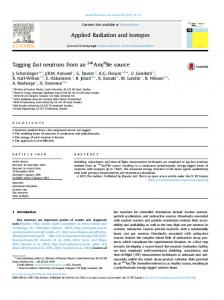
Model Compartments This modelling uses ordinary differential equations and the temporal resolution is one month to reflect seasonal variations. There are four main compartments (see Fig. 7): surface water, deep water, areas where, by definition, processes of fine sediment erosion and transport dominate the bottom dynamic conditions (ET areas) and areas with continuous sedimentation of fine particles, the accumulation areas (A areas; for more details on bottom dynamic conditions in lakes, see Håkanson and Jansson 1983). The inflow of TP to a given lake is handled by the following two fluxes, tributary inflow (F in) and direct atmospheric fallout (F prec).
Fig. 7 An outline of the structure of the dynamic lake model for phosphorus
Note that all TP emissions from point sources should be included in the tributary inflow. The internal transport processes of TP are: sedimentation from surface water to deep water (F SWDW) and to areas of erosion and transportation (F SWET), resuspension from ET areas either back to surface water (F ETSW) or to deep water (F ETDW), sedimentation from deep water on accumulation areas (F DWA), diffusion of phosphorus from A sediments to deep water (F ADW), upward and downward mixing, i.e., the transport from deep water to surface water (F DWSWx) and from surface water to deep water (F SWDWx) and burial (F bur), i.e., the transport from surficial (0–10 cm) A sediments to deeper sediment layers. The transport from a lake is regulated by the outflow from surface water (F out). All equations will be motivated in the following text and they are compiled in Table 4. When there is a partitioning of a flow from one compartment to two or more compartments, this is handled by a distribution coefficient (DC). This could be a default value, a value derived from a simple equation or from an extensive sub model. There are four such distribution coefficients in the TP model: 1. The DC regulating the amount in particulate and dissolved fraction. A default value for the particulate fraction, PFԜ=Ԝ0.56, has been used in all these simulations for phosphorus, as motivated in Fig. 8. 2. The DC regulating sedimentation either to areas of erosion and transport (ET areas) above the theoretical wave base (D wb; F SWET) or to the deep-water areas beneath the theoretical wave base (F SWDW, see Fig. 9). 3. The DC describing resuspension flux from ET areas back either to the surface water (F ETSW) or to the deep water compartment (F ETDW). 4. The DC describing how much of the TP in the water that has been resuspended (DCres) and how much that has never been deposited and resuspended (1 DCres).
Fig. 8 The relationship between empirical PP (particulate phosphorus; logarithmic values; PP in milligrams per cubic meter) and empirical TP (total P; logarithmic values in milligrams per cubic meter). The figure the regression line based on individual data (nԜ=Ԝ156) as well as the particulate fraction (PF). Data from Håkanson and Boulion (2002)
Fig. 9 The ETA diagram (erosion–transportation–accumulation; for more information, see Håkanson and Jansson 1983) illustrating the relationship between effective fetch, water depth and bottom dynamic conditions. The wave base (D wb) can be used as a general criterion to differentiate between surface water and deep water in systems
Determination of the Different Compartments From a mass-balance perspective, it is necessary that the four compartments (surface water, deep water, ET areas and A areas) included in LakeMab are defined in a relevant manner. The water depth that separates the surface-water and the deep-water compartment could potentially be related to (a) water temperature conditions and the thermocline, (b) vertical concentration gradients of dissolved materials or suspended particles, (c) wind/wave influences and wave characteristics and (d) sedimentological conditions associated with resuspension and internal loading (Håkanson et al. 2004). In this work, the separation is done by sedimentological criteria meaning that the volumes are separated by the theoretical wave base, D wb (Fig. 9, Håkanson and Jansson 1983). By definition, the theoretical wave base also determines the limit between ET and A areas. D wb is calculated from lake area (note that the area should be in squared kilometers in Eq. 2, giving D wb in meters), which is related to the effective fetch and how winds and waves influence the bottom dynamic conditions: (2) The accumulation areas (A) are calculated according to Eq. 3 below (from Håkanson 1999): (3) where AreaA is the area below the wave base (the accumulation areas). So, to calculate AreaA, and hence also the ET area, AreaETԜ=ԜAreaԜ−ԜAreaA, data are needed on the maximum depth (D max), the theoretical wave base (D wb), and the form factor (=volume development), Vd (VdԜ=Ԝ3·D m/D max, where D mԜ=Ԝthe mean depth). The fraction of ET areas
(ETԜ=ԜAreaET/Area) is used as a dimensionless distribution coefficient. It regulates the sedimentation of particulate TP either to deep-water areas or to ET areas and hence also the amount of matter available for resuspension on ET areas. For simplicity, this approach is used also when there is an ice cover (if the surface water temperature, SWT, is 0°C). ET generally varies from 0.15 (see Fig. 10), since there must always be a shallow shore zone where processes of erosion and transport dominate the bottom dynamic conditions, to 1 in large and shallow areas totally dominated by ET areas, which is the situation in areas where D wbԜ