Indexed in Scopus Compendex and Geobase Elsevier, Chemical Abstract Services-USA, Geo-Ref Information ServicesUSA, List B of Scientific Journals, Poland, Directory of Research Journals www.cafetinnova.org
February 2014, pp 27-38 ISSN 0974-5904, Volume 07, No. 01
An Integrated Approach to Augment the Depleting Ground Water Resource in Bist-Doab, Region of Punjab, India MANISHI SHARMA1, M. SOMESHWAR. RAO2, D. S. RATHORE2 AND GOPAL KRISHAN2 1
2
NIIT University, Neemrana, Rajasthan, India National Institute of Hydrology, Roorkee, India Email:
[email protected].
Abstract: Water is the most essential component for all the living things. Ground water is commonly used for drinking, domestic purposes, Industrial, irrigation etc. In many parts of the world, ground water is depleting at alarming stage. In recent years modern techniques such as remote sensing, GIS, Isotopes etc., along with conventional hydrological methods are increasingly getting used for ground water resource development and management .In the present study a multi- technique approach is taken up to identify and map ground water vulnerable zones and suitable zones to augment the depleting ground water conditions in Bist – doab (Bist- ‘ Beas– Satluj’ and doab- ‘a Persian i.e. a land mass between two rivers’) region of Punjab, India. Though the study area is covered by two major perennial rivers: Beas and Satluj, yet the long term ground water trend clearly indicate a continuous falling trend in major parts especially, in the central & south- central region. In this paper, conventional data has been compiled to map the changing ground water conditions, modern techniques have been used to generate land –use maps for estimation of spatio – temporal changing water demand, isotopic techniques to identify effectiveness of surface water source in ground water recharges etc. The satellite images of the study area were used as raw data for finding suitable location for constructing the water bodies in the study area. With the help of remote sensing and GIS thematic maps such as land use and land cover map, slope map, and drainage map were generated which are used for the identification of suitable water harvesting structures. The result obtained from the integrated data has been used in developing a working plan to identify suitable sites to increase surface water potential, measures to augment the falling water table and management plan to reduce excess pressure on ground water. Key words: Bist – doab region, water harvesting structures, remote sensing and GIS, isotope, ground water table. 1.
Introduction:
Groundwater is the underground water which occurs in the saturated zone of earth surface. The primary resource of groundwater recharge is precipitation and other surface water sources such as canal, pond, drain, also contribute over a time depending upon its transverse in the area of recharge. Ground water utilized through wells and tube wells. Groundwater is an essential resource for drinking, irrigation and industrial purposes. Ground water is a major and most valuable natural resource .The use of ground water has increased in past few decades due to tremendous increase in population as the population increases the production of crops and industrialization also increases. The BistDoab region of Punjab, India is facing severe groundwater stress due to intensive agricultural and other activities [1]. The economy of the state depends mainly on agriculture. The total geographic area used for agricultural purpose in the state is about 85% of the total area out of which 97% area is irrigated.
Around the world, groundwater resources are under increasing pressure caused by the intensification of human activities and other factors such as climate changes. Reductions in groundwater stores have implications for the water cycle because groundwater supplies the base flow in many rivers and it supports evapo-transpiration in high water table regions. Reductions in groundwater storage also have major implications for water quality [2, 3] because the salinity of the extracted water frequently increases as the volume of the reservoir decreases. Unfortunately the mismanagement and inordinate use of water led to ever increasing water demand. As ground water is dynamic and interdisciplinary in nature, an integrated approach of remote sensing and GIS technique is very useful in various groundwater management studies. Hydrological, geological and geomorphologic factors play a major role in the occurrence and movement of groundwater in different terrains. Now we can do assessment of groundwater with the help of advance space technology. The major function of this advance technique is to create thematic maps for better understanding. In
#SPL02070104 Copyright ©2014 CAFET-INNOVA TECHNICAL SOCIETY. All rights reserved.
28
An Integrated Approach to Augment the Depleting Ground Water Resource in Bist-Doab, Region of Punjab, India
groundwater resources artificial groundwater recharge plays a vital role. Developing of artificial underground reservoir for storing water called recharging of underground water. It is quite advance as compared with dams, reservoirs etc. 2.
Climate:
The climate of the study area is mostly tropical. The Himalayan barrier effectively shuts off the sub continent from the cold northerly winds of the Asiatic continental shield and at the same time bottle up and concentrates the monsoon winds blowing up from the tropical seas. The contrast between summer and winter is well marked, and these two primary seasons are associated with two main crop seasons of kharif in winter and rabbi in summer. The Bist-Doab region is semi-arid to sub-humid. Its average annual rainfall is slightly more than 60 cm. Year-to-year fluctuations are great which may be about 25 percent on either side of the annual rainfall. Rainfall varies from about 150 cm in the Shivalik hills in the north and northeast to less than 25 cm in the west and southwest. Rainfall belts parallel to the Shivalik hills, and the amount of rainfall declines as one move from them. The number of rainy days also differs in the same manner. The Shivalik hills may receive rainfall of at least 2.5 mm on about 45 days in year. About 70 per cent of the annual rainfall is received during the monsoon months of July to mid-September. The winter rainfall, brought about by the western cyclones, accounts for 15 per cent of the total. Some rainfall may occur during the pre-monsoon months of June and the post-monsoon month of October. April, May and November are the driest months in a year. Another notable feature of rainfall is its high degree of variability in terms of its amount, time of onset and departure, and distribution within the rainy season. There is a strong negative relationship between the amount of rainfall received and the degree of its variability. In other words, the reliability of rainfall in arid and semiarid parts of Punjab is much less. This makes irrigation virtually indispensable, particularly in areas with low rainfall. The intensity of rainfall also varies through both time and space. The intensity of summer rainfall is stronger than that of winter rainfall. The summer rain comes in torrents, the winter rain in drizzles. A rainfall of 12.5 cm in 24 hours is not uncommon during the monsoon period, while a rainfall of 5 to 7 cm in 24 hours during winter is rare. Also the intensity of rainfall is high on and near the Shivalik hills
and it gradually declines as one recedes towards the south and the southwest. For obvious reasons, the problems of water management in Bist -Doab region is related mainly to its rainfall regime that is distinguished by its inadequacy, seasonal concentration, great variability and high intensity. 3.
Study Area:
The Bist-Doab region of Punjab state is a triangular region and the area is covered by two perennial rivers Beas and Satluj which covers an area of 9060 km2. The area lies between 30º51' and 30º04' N latitude and 74º57' and 76º40' E longitude. The study area comprises the districts Hoshiarpur, Kapurthala, Jalandhar and Nawanshahar districts and parts of the districts Roop Nagar of Punjab State, India. It is bounded by Shiwaliks in the north-east, the river Beas in the north east-south west and the river Satluj in south east-south west. The area is drained by the perennial rivers Satluj and Beas and their tributaries. Both major rivers coalesce at the Harike. The flood plains are formed of new alluvium deposited by the rivers during the rainy season every year. The flood plain on the other hand is relatively extensive and wide. The flood plains of the Beas comprise a large part of Dasuya Tehsil of Hoshiarpur district and western half of Kapurthala Tehsil. Because of the westward shift of Beas the flood plain is much wider east of the river than to the west. On the western side it is separated from the upland plain by a relatively steep cliff which at places is more than 50 feet in height. The eastern side of the flood plain extends up to the Black Bein which is said to have been the old course of the Beas River. The flood plain of the Satluj River starts from near to Ropar district and extends up to the vicinity of Fazilka town in Ferozpur district. The flood plain is much wider in the south of the river to its north due to its westward shift of its course. A section of that plain lies between Satluj and Buddha nala which was the old course of the river. As the river moves into the arid areas further and further, the intensity of water in the river is decreases and accordingly the flood plain becomes narrow.
International Journal of Earth Sciences and Engineering ISSN 0974-5904, Vol. 07, No. 01, February, 2014, pp. 27-38
MANISHI SHARMA, M. S OMESHWAR . R AO, D.S. R ATHORE AND G OPAL KRISHAN
29
Fig1: Bist Doab region in Punjab, India
Fig2: Flow Chart for mapping of groundwater recharge zones 4.
Methodology:
The main objective of this study is to find out suitable locations for groundwater recharge for developing the new dams and interlinking between canals and river to improve the water table level in the study area. For this study we compile two approaches among them one is remote sensing and GIS approach (satellite) while another one is Isotopic (Hydrologic) approach. In satellite approach we used IRS-P6, LISS-III with 23.5 m spatial resolution for preparation of land use and land cover map. For other maps we used ARC GIS software. All the thematic layers were integrated with ARC GIS software to demarcate artificial groundwater recharge zones. The hydrological approach was carried out to examine water quality, its suitability for drinking needs
and to identify the effective recharge sources in the study region. The water quality analysis shows that the shallow and intermediate aquifer is marginally less alkaline as compared to deeper aquifer. The electrical conductivity of the groundwater in the shallow aquifer is in general higher compared to intermediate and deep aquifers, indicating contamination from surface activity. 5.
Result and Discussion:
5.1 Satellite Approach: 5.1.1 Geomorphology: Geomorphology of this area can be broadly divided into eight zones (Figure: 2) [4],
International Journal of Earth Sciences and Engineering ISSN 0974-5904, Vol. 07, No. 01, February, 2014, pp. 27-38
30
An Integrated Approach to Augment the Depleting Ground Water Resource in Bist-Doab, Region of Punjab, India
i. Structural Hills of Siwalik occupying 12000 Km2 of area in the North East portion of the BistDoab ii. Gently undulating Table Land located in the eastern corner of the Doab iii. Semi-consolidated boulder Upper Piedmont, iv. Relatively less course texture Lower Piedmont v. Central triangular shape Alluvial Plane vi. Sandy and saline tract in the NE to SE part of Kapurthala & Jalandhar districts, vii. Flat and wide Older Flood Plains viii. Active Flood Plains occupies narrow strip along the bank of the two rivers and present day active channels. The Structural Hills are made up of predominating bands of clays alternated with sands of varying grade. Number of small seasonal streams in this region is responsible for extensive erosion of this zone. The hills are covered with sparse vegetation, mainly bushy
in nature with tree cover varying from 10 to 30% at places. The upper piedmont is characterized by the presence of extremely dissected large number of subparallel streams. The area is marked by poor vegetation and is under rain fed cultivation. In the Lower Piedmont zone, the drainage pattern becomes parallel. In this zone, the tree population is high and at places natural forests and orchards are dense, specially, in the south eastern corner. The cultivation in this zone is mostly through tube well irrigation. Alluvial plains contain clay and sand mixed soils of alluvial origin. The soils are fine loamy in the lower reaches and coarse loamy in the upper reaches. This zone is under intensive cultivation and irrigated by both canals as well as tube well irrigation. Sandy and Saline zone represents earlier level deposits wide flood plain. The newer alluvium of Active Flood Plains is poor in calcareous matter.
Fig3: Geo-morphological map of Bist-Doab [4]
International Journal of Earth Sciences and Engineering ISSN 0974-5904, Vol. 07, No. 01, February, 2014, pp. 27-38
MANISHI SHARMA, M. S OMESHWAR . R AO, D.S. R ATHORE AND G OPAL KRISHAN
31
Fig4: Drainage and canal system Map Geomorphologically, the Bist Doab is divisible into three zones:
The Shiwaliks The Kandi Watershed The interfluvial plain
The flood-plain area the existing and earlier Beas, Sutlej and other rivers deposited a great thickness of Pleistocene to recent sediments derived from erosion in the mountains. The relevant lithologies and sequences are as follows: Surface deposits (Recent). Sirowal sediments and occasional gravels to the northeast with Kandi coarse clastics including red clay beds to the southwest (Holocene). Boulder beds with inter-bedded clays (Pleistocene). The alluvium at the surface reflects the latest stages of sedimentation in a process which commenced in the Tertiary. Cenozoic sedimentation involved sediments in the Shiwaliks which can be divided into late, middle and early portions. The upper part ranges in age from middle Pleistocene downwards and comprises three members which are as follows:
Boulder conglomerate (middle Pleistocene) Pinjore lithic arenites (late Pliocene) Tatrot sediments (Neogene).
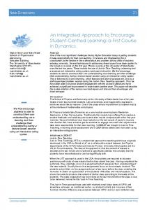
The groundwater data collected for Shallow and deep aquifer for the year 2002 and 2008 collected form CGWB is converted into contours (msl) to map the flow direction of groundwater in shallow and deep
aquifer. The groundwater flow in shallow and deep aquifers is mainly in the direction diagonally along NE-SW direction from Shivalik- Kandi to confluence of rivers near Harike and along east-west direction in the southern part of the study area parallel to the River Satluj. Since, both surface and groundwater are flowing and accumulating towards confulance zone as a result, groundwater at Harike is at shallow depth (closed to near surface) and is also resulted into waterlogging. The groundwater fluctuation in the shallow aquifer (Fig. 5a) is high upto 7m in Hoshiarpur district and 5m in Jalandhar district in six years. The groundwater in deep aquifer (Fig. 5b) show high fluctuation mainly at the central part with maximum of 7m fall in six years. The groundwater draft has been continuously increasing in the Bist- Doab region. The contour of groundwater availability (Fig. 3) shows maximum availability in this region (>15000MCM) upto 5-20 km near the river Satluj and in Mukerian block near river Beas. The groundwater availability decreases from central zone to central region of Kandi. The Jalandhar district shows maximum amount of groundwater draft (Fig. 6) with maximum of 30,000MCM per year. The groundwater stage in the region shows that most of the area is over exploited. 5.1.2 Land Use / Land Cover: LCLU is an important indicator of the extent of groundwater requirements and utilization as well as in the selection of sites for artificial recharge of
International Journal of Earth Sciences and Engineering ISSN 0974-5904, Vol. 07, No. 01, February, 2014, pp. 27-38
An Integrated Approach to Augment the Depleting Ground Water Resource in Bist-Doab, Region of Punjab, India
2009
2008
2007
2006
2005
2004
2003
1999
Depth < 50 m
2002
agriculture, wetland, and water- bodies. The major land cover area in the study area is agriculture land. 2001
groundwater. The major land use / land cover classes in the study area are built – up, wasteland, forest,
2000
32
0 Depth to Water Table
Catchment Area
2002-2008
Flow Direction Dams Ridge Line
5
10 15 20 25 Durimiwal Nakodar
30
Garhshankar Dasuya
35
Depth < 50 m -1 (Rise) 0
+1(Fall)
Topographic Elevation 220
240
260
300
340
380
420
-1 -0.5 0
460 (m)
1
2
3
4
5
7m
6
Depth to Water Table (bgl)
Catchment Area Flow Direction Dams
Ridge Line
25
Shahkot Dasuya
+1(Fall)
220
240
260
300
340
380
420
3
4
5
6
460 (m)
Fig5b: Groundwater flow pattern and fluctuation in Deep aquifer
International Journal of Earth Sciences and Engineering ISSN 0974-5904, Vol. 07, No. 01, February, 2014, pp. 27-38
7
8m
Adampur Balachaur
2009
2008
2007
20
0
2
2006
15
-1 (Rise)
1
2005
5
10
Depth > 150 m
0
2004
0
30
Topographic Elevation
2003
2002
2001
1999
2002-2008
Depth > 150 m
2000
Fig5a: Groundwater flow pattern and fluctuation in shallow aquifer
MANISHI SHARMA, M. S OMESHWAR . R AO, D.S. R ATHORE AND G OPAL KRISHAN
5300
9300
13300
17300
21300
25300
29300 (MCM) 600
Groundwater Availability
10600
20600
30600
Groundwater Draft
Fig6: Groundwater availability and drafting in Bist-Doab region
Fig7: LCLU Map
International Journal of Earth Sciences and Engineering ISSN 0974-5904, Vol. 07, No. 01, February, 2014, pp. 27-38
33
40600 (MCM)
34
An Integrated Approach to Augment the Depleting Ground Water Resource in Bist-Doab, Region of Punjab, India
Fig8: Drainage Density map
River Main Drainage Tributaries of Drainage Main Canal Canal Distributary Main Canal Unfunctional Dams
Link 1
Link 3 Link 2
Link 4
Fig9: Proposed Links from Beas River to Central part 5.1.3 Drainage: The drainage density is the length of channels per unit area which indicates an expression of the closeness of spacing of channels. It thus provides a quantitative
measure of the average length of stream channels within different parts of the whole basin. The drainage density is an inverse function of permeability and thus indirectly indicates the
International Journal of Earth Sciences and Engineering ISSN 0974-5904, Vol. 07, No. 01, February, 2014, pp. 27-38
MANISHI SHARMA, M. S OMESHWAR . R AO, D.S. R ATHORE AND G OPAL KRISHAN
suitability for groundwater recharge of an area. Based on the drainage density of the micro-basin, the study area was grouped as poor, moderate and good with their respective range. 5.1.4 Management Measures and Recharge of Shallow Groundwater:
Artificial
The stable isotopic study shows recharge from BistDoab canal is very minimal and the rain water act as a main source of groundwater recharge in this region. The tritium dating method shows the shallow groundwater gets recharge mainly in the northern part of Bist- Doab region especially near in the Kali Bein catchment. The Kali Bein catchment, in the northern part of Bist- Doab region, shows excess availability of groundwater where as the White Bein catchment, in the central and southern part of Bist-Daob region shows very old groundwater indicating very little recharge. Satluj River is also diverted for the southern part through Sirhind canal at Ropar head works. The water diverted from Satluj River is maximum for Sirhind canal (12622Cs) where as Bist- Doab canal is (1408Cs). In case of Beas River, it is acting as a natural conduit to transfer water from Pong dam to Harike. The only canal which diverts water is Shah Nehar/ Kandi canal which transfers water (11500Cs) from R. Beas to Kandi zone of Bist- Doab region. The water transferred is huge and covers little area when compared with the Bist- Doab canal which covers large area. Hence, this water can be additionally passed through Bist- Doab region to decrease groundwater stress and to make the canal and local streams perennial and increase recharge conditions in the region. With the assumption that water for the Bist- Doab region can be taken only from Beas River four viable links are identified: Link1&3: for increase water in western parts Link 2: between Kali bein and White Bein rivers Link 4: Central & Southern part (to make white Bein perennial)
Beas river and head works (Origin point) of Kali Bein and using the Kali Bein to transport water, then the water from Kali Bein can be linked to Bist- Doab canal by constructing a joining canal and Bist- Doab canal be used for
35
distributing water to the central and southern parts Keeping Kandi canal perennial and joining Kandi canal with White Bein for distribution of water for central and southern region, as the Kandi canal is in lower level when compared with the level of Satluj canal a direct link can be made. Or the aqueduct (Kandi canal and the seasonal streams/ White bein) can be connected with Kandi canal and seasonal stream/ White Bein. The local and major dams (like Maili, Dolbaha, Pong dam etc.) can be judiciously used for keeping the Kandi canal perennial.
This was based on the minimum distance between two stream/ stream and canal/ canal – canal which are to be connected with minimal disturbance to the existing network. This has also taken construction cost of these links into account. This management measure will help to increase the perennial conditions of surface water sources, and augmenting the surface water condition without affecting the local environment. Maintaining the required water discharge in Beas river will help to maintain the local ecology. As water from all these streams, canals confluve at Harike through well controlled network of streams and canals the water logging problem at Harike can be made more eco friendly. The proposed links fulfills water requirement for the entire BistDoab region and reduces the stress on Satluj river by inter linking Beas river with Satluj canal network. The groundwater recharge zones(Fig:10) for the study area were obtained by integrating thematic layers of geomorphology, geology, land use/land cover map, drainage map, and specific yield using GIS techniques. The demarcation of groundwater recharge zones was made by grouping of the interpreted layers through ArcGIS software. In the above shown map we showed the best suitable locations for groundwater recharge to improve the water table of the study area.proposed dam 1to 6 are under black bein while proposed dam 7 to 11 in white bein.
International Journal of Earth Sciences and Engineering ISSN 0974-5904, Vol. 07, No. 01, February, 2014, pp. 27-38
36
An Integrated Approach to Augment the Depleting Ground Water Resource in Bist-Doab, Region of Punjab, India
Suitable locations for Dams for recharging groundwater
Locations 1. Toye, near Dasuya 2. Chandi Das 3. Between Dharampura and Bhodal 4. Dawakhri 5. Dhuriyan 6. Sherpur Khan 7. Deshmesh nagar 8. Patti 9. Manolian 10. Sakruli 11. Saila Khurd
White Bein Catchment Area Black Ben Catchment Area Possible locations of Construction of minor Reservoirs/ Check dams
1 2 34 5 6 7
8
9
1011
R. SATLUJ
Fig10: Suitable locations for check dams
Fig11: Natural recharge area of zones of deep
aquifiers identified using isotope technique
International Journal of Earth Sciences and Engineering ISSN 0974-5904, Vol. 07, No. 01, February, 2014, pp. 27-38
MANISHI SHARMA, M. S OMESHWAR . R AO, D.S. R ATHORE AND G OPAL KRISHAN
37
Fig12: Recharge the groundwater through the beas river (Values are% river water in shallow aquifier 5.2 Hydrological Approach: The groundwater samples from different aquifers (shallow (60m)) and, also precipitation and river water samples collected during various field work from during 20072010 were analyzed for major ions and isotope of water. The analysis was carried out to examine water quality, its suitability for drinking needs and to identify the effective recharge sources in the study region. The water quality analysis show that the shallow and intermediate aquifer are marginally less alkaline (pH values ranges from 7 to 8) compared to deeper aquifer (pH ranges from 7.6 to 8.2). The electrical conductivity (EC) of the groundwater in the shallow aquifer is in general higher compared to intermediate and deep aquifers, indicating contamination from surface activity. However, in general, groundwater quality is within permissible limit of WHO standard at all locations. The groundwater in shallow and intermediate aquifer is Ca-Mg-HCO3 and in deep aquifer is NaHCO3 type. The isotopic data reveal that the groundwater in deep aquifer gets recharged mainly from the precipitation from hilly region and it flows almost in confined to semi-confined conditions (towards the confluence region of the rivers- Beas and Satluj with intermittent recharge from shallow aquifers at few locations. The shallow groundwater gets recharged through rainfall over major part of the region. River Beas contribution to the groundwater is significant only close (within a kilometer) to the river flood plain. The recharge to groundwater from the river Satluj is insignificant. Although the study area has good density
of canal network but recharge percentage due to canalgroundwater interaction is also very small compared to the recharge from precipitation. Since rainfall is the major contributor compared to all the recharge sources recharging to groundwater, the groundwater condition is highly sensitive to rainfall pattern i.e, sensitive to climate variability. Since, deep aquifers are recharged mainly due to rainfall occurring in Siwalik region (and low interaction with shallow aquifers in the plain area) the groundwater conditions in deeper aquifer can be improved by developing recharge structures in hilly terrain and by developing deep-well recharge structures in plains. Without artificial recharge measures the piezometeric head in deeper aquifers is expected to fall rapidly with continuous withdrawal from deep aquifer. 6.
Acknowledgement:
Authors are thankful to Director, National Institute of Hydrology (NIH), India for extending support to provide the labs for remote sensing & GIS and allow to work in Isotope Hydrology. 7.
Conclusion:
The groundwater recharge zones map indicates that the excellent groundwater recharge zone is concentrated in some parts of middle and western portion of Bist Doab region due to the distribution of flood plains, alluvial plainand agricultural land with infiltration capacity.The eastern portion of the Bist doab region is not suitable for artificial groundwater recharge due to its poor infiltration capacity. The groundwater recharge zones delineationin the present study using integrated approach with remote sensing & GIS and isotope are
International Journal of Earth Sciences and Engineering ISSN 0974-5904, Vol. 07, No. 01, February, 2014, pp. 27-38
38
An Integrated Approach to Augment the Depleting Ground Water Resource in Bist-Doab, Region of Punjab, India
reliable and can be used for planning the artificial recharge projects for sustinable groundwater utilization. Moreover, these approaches will increase the water table of the study area which will reduce the pressure of crisis. 8.
References:
[1] Gopal Krishan, A.K. Lohani, M.S. Rao, and C.P. Kumar, Optimization of groundwater monitoring network in Bist-Doab, Punjab. In: Proceedings of an International conference “India Water Week 2013-Efficient Water Management: Challenges and Opportunities" (IWW-2013), 08-12 April 2013 at New Delhi, India. Pp. 274, 2013. [2] Gopal Krishan, M.S. Rao, C.P. Kumar, Prabhat
Semwal, Naresh Tuli and G.S. Gill, Groundwater quality and stable isotopic composition in Southwest, Punjab. In: Proceedings of International conference on “Integrated Water, Waste Water & Isotope Hydrology IC-WWISH-2013”, 25-27 July 2013 at Bangalore University, Bangalore, India. III (VI): 6-10, 2013 [3] Gopal Krishan, M.S. Rao, C.P. Kumar and Prabhat Semwal, Identifying salinization using isotopes and ion chemistry in semi-arid region of Punjab, India, Journal of Geology and Geosciences, 2:4, 2013, http://dx.doi.org/10.4172/jgg.1000129 [4] Singh, I.B, Sedimentological history of Quaternary deposits in Gangetic plains. Indian Joun. Earth Sci., 14, 1987, 272-282.
International Journal of Earth Sciences and Engineering ISSN 0974-5904, Vol. 07, No. 01, February, 2014, pp. 27-38