point M and AM is saved as common offset. So the. AB trajectory ..... and M. E. Cannon, "A Portable Vehicular ... Angus P. Andrews, Global Positioning. Systems ...
Intelligent Vehicles Symposium 2006, June 13-15, 2006, Tokyo, Japan
3-9
Offset Eliminative Map Matching Algorithm for Intersection Active Safety Applications T. Ardeshiri, S. Kharrazi
R. Thomson
J. Bargman
Autoliv Research SE-447 83,Vargarda Sweden
Dept. of App. Mechanics Chalmers Univ. of Tech. SE-412 96, Gothenburg Sweden
Autoliv Research SE-447 83, Vargarda Sweden
calibration and data fusion algorithms, inaccuracies are often inevitable in CPS given positions. Hence, positioning results do not always match onto the digital road map. Therefore, map matching algorithms are usually used to match the positioning results with digital road map to determine the location of a vehicle with respect to the road network.
Abstract Digital map information and Continuous Positioning Systems (CPS) are being increasingly used in active safety applications. However due to imprecision associated with digital road maps and inevitable inaccuracies in CPS positions, a map matching algorithm is essentialfor these applications. One field of active safety in which navigation information can be used is Intersection Active Safety Applications (IASA) which requires a precise position of vehicle relative to road network in an intersection. In this paper a novel map matching algorithm for an IASA is presented. To determine the vehicle trajectory relative to the road network, the proposed map matching algorithm calculates the general offset between digital road map and the CPS given vehicle trajectory by fusion of local offsets with a Kalman filter, incorporating their respective uncertainties. The created offset eliminative map matching algorithm was tested on a complex urban trajectory and showed very encouraging results.
Map Matching (MM) algorithms vary from simple point-by-point matching to shape matching and from position-only matching to position and velocity mapping. Ochieng et al. (2003) and Basnayake et al (2003) have discussed some of these algorithms. In all of these map matching algorithms, the given vehicle position by CPS is matched on the road's centerline, in other words the given vehicle trajectory by these map matching methods follows the roads' centerline pattern and vehicle maneuvers on the road such as lane changing and turning in an intersection can not be presented. For example vehicle turning in an intersection will be presented by an in place turning on the node where centerlines of intersected roads meet.
1. Introduction
However in an Intersection Active Safety Application (IASA), vehicle's trajectory nearby an intersection is of great importance. Therefore in the proposed map matching algorithm in this paper, the vehicle trajectory pattern is kept as estimated by CPS and only the offset between CPS estimated trajectory and digital road map is eliminated.
Digital road maps are used in land navigation systems as an additional sensor which utilize the restriction of land vehicles to the road network and provide information about the vehicle's position relative to the road network. However, there is also imprecision with digital road maps due to road curvature approximation with piece-wise linear segments, single line modeling of multi lane roads, lack of information about intersections geometry, etc. Moreover, even with very good sensor
Another important factor in an IASA is accuracy of estimated distance to upcoming intersection. Large errors in estimation of distance to upcoming
82
Intelligent Vehicles Symposium 2006, June 13-15, 2006, Tokyo, Japan
determine the vehicle location relative to the road network. This offset, referred to as Common Offset in this paper, is calculated as explained in the following section.
intersection can cause incorrect application of intersection countermeasure logic, which are invoked when the vehicle is within a certain distance to upcoming intersection.
The proposed map matching algorithm enabled laser radar application and driver behavior study in intersections which require an accuracy of 2 meters in estimation of vehicle distance to upcoming intersection. This accuracy was achieved by the implementation of the proposed map matching algorithm on the given trajectory by the CPS system developed by the authors [1].
2. Proposed Map Matching Algorithm In this section the proposed map matching algorithm is presented.
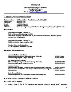
Figure 1. Test Trajectory, Alings'as, Sweden
2.1. Algorithm Inputs
100
The inputs of the proposed map matching algorithm are the digital map information and the locational data given by a CPS, including position, heading and associated uncertainties. The utilized information from digital map includes road centerline, directions of travel on each road (two ways/one way) and speed limit from which the road width was estimated.
50
-
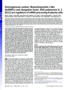
Gi\en Position by GPS Estimated Trajectory by CPS Road Map
0 T -50 '
-100
z -150 -200 -250 -300
The Continuous Positioning System employed an Extended Kalman Filter, developed by the authors, to fuse data from GPS receiver, fiber optic gyro, accelerometers and wheel odometer. For more information regarding the sensor fusion algorithm refer to [1].
-350 -500
-400
-300
-200 -100 Easting [m]
0
100
Figure 2. CPS estimated trajectory and digital roadmap
2.3. Offset Eliminative Algorithm Offset between CPS positions and traveling road can be both in lateral and longitudinal direction. Lateral offset can be simply estimated as the minimum lateral displacement which should be applied on a given position to shift it within the road width and on the correct side of the road centerline. Longitudinal offset can not be estimated as easily as lateral offset, however knowing the longitudinal offset is of great importance in an IASA and can
2.2. Test Trajectory To compare the CPS results with the digital map, a test was conducted in Alingsas, Sweden. Figure 1 shows the full test trajectory which was close to 2 km long and included 14 turns in intersections. A comparison between the estimated vehicle trajectory by CPS and the digital road map, shown in Figure 2, indicates a general offset between them. The proposed MM algorithm estimates this offset to
83
Intelligent Vehicles Symposium 2006, June 13-15, 2006, Tokyo, Japan
lead to elimination of error in calculated distance to upcoming intersection. When a vehicle turns, the lateral offset between vehicle position and its respective point on the traveling road will become a longitudinal offset. Considering this fact, in the proposed MM algorithm, common offset is calculated by addition of local offsets as explained in the following example.
offset becomes AM + NO which is equal to CP offset at point C.
L-----
Assume that the ABC trajectory in Figure 3 is given by CPS. With a simple comparison between this trajectory and road map, it can be inferred that the real trajectory should be EFG.
--
L
Xi
J-J- K IT
A
Figure 4. Typical CPS trajectory (ABC),road map and lateral offset removal MM solution trajectory (HIJKJL)
. I
r-
|