ing the transfer of heat via hot volatiles, and that mechanical thinning or necking ...... Basin and Range province: Nappe tectonics in an extending orogen: Nature ...
Journal of Afrkan Earth Sciences, Vol. 8, Nos. 2/3/4, pp. 191-201, 1989
0899--5362/89 $3.00 + 0.00 © 1989 Pergamon Press plc
Printed in Great Britain
Basin and Range style tectonics in East Africa WILLIAM BOSWORTH Marathon International Oil Company P.O.Box 3128, Houston,Texas, USA 77253 Abstract-- Geophysicaland geologicalevidencesuggest that the asthenosphericstructurebeneath the presentlyactiveeast Africanrifts resembles that of the Basin and Range tectonicprovinceof the western United States. Both regions are underlain by anomalouslythin lithosphereriding on hot asthenospheric pillows that extend laterally for as much as 1500 km normal to structural trend. The continental rifts associated with theseterranesdo not appearto be leading to plate separation, and youngoceanicrifts such as the Red Sea probablyevolved from narrower, more restrictedmantle thermal anomalies. Low-angle normal faults are interpreted to control the physiographyand structural style in the east Africanrifts in a fashion analogous to that proposed for the Basin and Range. The limited horizontalextensionthat has occurred in east Africa, however, requires that mechanical thinning of the lithosphere must play a subsidiary role to thermalerosion from below.The upwardmigrationof mantle isothermshas converted the base of the lithosphere to material with asthenospheric properties beneath thousands of square kilometers of crust. The presence of a broad zone of thin, warm lithosphere in both these tectonic provinces may help to distribute extensionalstrains over correspondinglybroad regions. This in turn is expected to result in the developmentof numerous detachment surfaces (and correspondingsurficial rifts), none of which ever completelythin the lithosphereor evolve to oceanic-stylerifts. INTRODUCTION
It h a s b e e n s u g g e s t e d t h a t the e a s t e r n b r a n c h of t h e E a s t African Rift S y s t e m m a y r e p r e s e n t a n ear ly s t a g e in t h e evol ut i on of a divergent lithos p h e r i c p late b o u n d a r y (Baker a n d o t h e r s 1972). T h i s c o n c e p t is s u p p o r t e d b o t h by t he e x t e n s i o n al n a t u r e of s u r f a c e s t r u c t u r e s in t he rifts (Willis 1936. B a k e r a n d o t h e r s 1972), a n d by the lateral c o n t i n u i t y b e t w e e n g e o p h y s i c a l a n d geological f e a t u r e s of t h e E a s t African rifts a n d t r u e oceanic rifts in t h e Red S e a a n d G ul f of A d e n (Fig. 1; S u e s s 1891, M o l n a r a n d Oliver 1969). Many a t t r i b u t e s of t he e a s t e r n b r a n c h rifts, however, ar e atypical of t h e gr e a t m a j o r i t y of P h a n e r o z o i c c o n t i n e n t a l rifts (King 1978. B o s w o r t h a n d o t h e r s 1986). T h e q u a n t i t y of volcanic r o c k a s s o c i a t e d with t h e E a s t African Rift S y s t e m is several o r d e r s of m a g n i t u d e g r e a t e r t h a n t h a t f o u n d in m o s t c o n t i n e n t a l rifts (Logatchev a n d Fl orensov 1978, King 1978). O t h e r c o n t i n e n t a l rifts, s u c h as t h e G u l f of S u e z w h e r e t he pre-rift N u b i a n S a n d s t o n e is a p r i m a r y r e s er voi r objective, g e n e r a l l y u n d e r g o a n initial period of subsi dence. In E a s t Africa in t he vicinity of the G r e g o r y Rift, however, early regional uplift h a s b e e n well d o c u m e n t e d (Saggerson a n d B a k e r 1965, B a k e r a n d W o h l e n b e r g 1971). Rifting m o d e l s t h a t envi s i on E a s t African-like beginn i n g s s h o u l d t h e r e f o r e o n l y b e applied c a u t i o u s ly to o t h e r c o n t i n e n t a l rift settings.
T he c o n t i n e n t of Africa h a s e x p e r i e n c e d a long a n d c o m p l e x h i s t o r y of rifting t h a t c o m m e n c e d in the Proterozoic. M a n y of t he y o u n g e r rifts of E a s t Africa m a y follow s t r u c t u r a l t r e n d s established by Paleozoic a n d P r e c a m b r i a n ev e n ts (McConnell 1972, L a m b i a s e t hi s volume), b u t t he p e a k of African rifting is a Mesozoic a n d Cenozoic p h e n o m e n o n . Fig. 2 i l l u s t r a t e s th e g e n e r a l t r e n d s of k n o w n J u r a s s i c a n d y o u n g e r rifts in E a s t Africa, s e p a r a t e d into t h o s e rifts t h a t c o n t i n u e t h e i r e x t e n s i o n a l h i s t o r y into late T e r t i a r y or R e c e n t t i m es a n d t h o s e t h a t a p p a r e n t l y did not. S o m e of t h e s e t r e n d s , t he Abu G a b r a ( S o u t h e r n S u d a n ) a n d Nile. for exam p le (Browne a n d F a i r h e a d 1983, B r o w n e a n d o t h e r s 1985), are k n o w n only in t h e s u b s u r f a c e , suggesting t h a t yet o t h e r b u r i e d E a s t African rifts m a y still be discovered. T h i s p l e t h o r a of African rifts c o r r e s p o n d s to a time period d u r i n g w h ic h t he African l i t h o s p h e r i c plate w a s n e a r l y stat i o n a r y with r e s p e c t to t h e e a r t h ' s spi n axis, a n d B u r k e a n d W h i t e m a n (1973) h a v e s u g g e s t e d t h a t this peri od of immobility facilitated th e p e n e t r a t i o n of t h e African l i t h o s p h e r e b y upwelling m a n t l e p l u m e s . T h e ext ensi ve Cenozoic volcanic p r o v i n c e s of E a s t a n d C e n t r a l Africa s u p p o r t this h y p o t h e s i s . O x b u r g h (1978) h a s s h o w n t h a t the regional u p w a r d m i g r a t i o n of m a n t l e i s o t h e r m s n e c e s s a r y to a c c o u n t for E a s t African v o l c a n i s m c a n only be expl ai ned b y
191
192
WILLIAM BOSWORTH
20W 39N
35N
--
30N
--
15W
10W
5W
0
5E
10E
15E
20E ,
25E
30E
35E ,
45E . .
40E
.
50E . .
55E 39N
35N
30N
,
25N
25N
A,
BOUGUER
20N
ANOMALY
CONTOURS
MAP
20N
IN M I L L I G A L S
A 15N
15N
10N
10N
5N --
5N
B o
0 --
BOUGUER
5S --
~
k
&
~0
Y
PROFILES 5S
A I /
10S
RED SEA ANOMALY
'°°l
/ /~
J\
-50 y-
A' 10S
f
I/
:1
15S
20S
B
'
1 20S
B'
0
25S
-
/
-100 -140
-150
35S 36S 20W
25S
EAST AFRICAN /
-50
30S
/x,
30S
I
I
I
I
I
I
I
~
I
I
I
I
I
I
15W
10W
5W
0
5E
10E
15E
20E
25E
30E
35E
40E
45E
50E
-I 35s 36S 55E
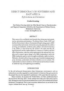
Figure 1. Selected contours from the long-wavelength Bouguer anomaly map of Africa prepared by Slettene and others (1973) with additional data in the Red Sea area from Girdler (1958). The area in black corresponds to values more negative than - 140 milliGals. Girdler and others (1969) have suggested that the low Bouguer values in East Africa represent an area of thermally thinned continental lithosphere associated with the active East African Rift System. Profiles A-A' and B-B' contrast the gravity signature of the narrow Red Sea oceanic rift and this broad zone of East African continental rifting.
active convection in the mantle, perhaps involving the transfer of heat via hot volatiles, and that mechanical thinning or necking of the lithosphere is of minor significance. Wendlandt and Morgan (1982) have related the ages and depths of differentiation of volcanic rocks found in East Africa to a progressive thinning of the lithosphere that spans the past 35 Ma. Although the largest volcanic piles in East Africa are actually located outside the rift valley proper, their position can be explained by the interaction between
rift extensional s t r u c t u r e s and the base of the regionally thin lithosphere (Bosworth 1987). The potential for anomalous crust or mantle beneath large areas ofAfrica was first recognized in the presence of extensive, high plateaus over m u c h of the continent and the occurrence of widespread volcanic rock on m u c h of this high ground. Krenkel (1922) related these features to partial melting in the u p p e r mantle. Similar interpretations have been applied to the long wavelength gravity field of Central and East
Basin and range style tectonics in East Africa
15E 20N
20E
25E
30E
35E
EAST AFRICAN RIFTS
~'X
40E
193
45E
50E
55E 20N
RED SEA RIFT
KHARTOUM•-~
~
- 15N
RIFTS NGAOUNDERE RIFT 1ON
"-~k
/~....-~~
\"~/~'¢)~
''~'~' ,
GULF oF ~OE.t4
" ~ , /'
•
" ~ ' - ~
._.L..
" l ON
ETHIOPIAN RIFT
ABU GABRA RIFT 5NI-
~,'--~
GaJ
_J
/
ALBERT RIFT
-I 5 N
RIFT
, \
KISANGANI• C OF
~
~
~
o
o
k-/
\~
":~ \
t 1
.~. .,
5S
.../
-'10
• NAIR( (EAST BRANCHE. AFRICAN RIFT SYSTEM)
•,.
5S
TANGANYIKA RIFT 10S
INDIANOCEAN RIFT SYSTEM)
15S
15S
20S 15E
10S
I
I
I
20E
25E
30E
I
35E
40E
45E
50E
20S 55E
Figure 2. General trends of continental rifts in East Africa active during Mesozoic to early Tertiary (Central African Rift System) and Tertiary to Recent (East African Rift System) times. Compiled from Baker and others (1972), McConnell (1972), Browne and Fairhead (1983), Browne and others (1985) and Reeves and others (1986/1987). The -100 milliGal gravity contour from Fig. 1 is included and indicates the approximate extent of significantly thinned continental lithosphere (Girdler and others 1969). The Mesozoic-early Tertiary Anza Rift passes beneath the active Gregory Rift at Lake 3Mrkana in northern Kenya (north of Nairobi on map) and may cause the break in the con tlnuity of the -100 milIiGal gravity low. The line of section of the geologic model of Fig. 5 is shown by C-C'. Africa (Fig. 1). Girdler a n d o t h e r s (1969) modeled the negative B o u g u e r gravity a n o m a l y t h a t corr e s p o n d s with t h e area of Cenozoic rifting in Africa as a region of c o n t i n e n t a l lithosphere with its b a s e replaced or altered to relatively less dense, h o t a s t h e n o s p h e r i c material. The width of the envisioned zone of lithospheric t h i n n i n g is a b o u t 1500 k m a n d c o r r e s p o n d s to B o u g u e r
v a l u e s more negative t h a n a b o u t - i 0 0 milliGals. It h a s b e e n s u g g e s t e d t h a t the geophysical s i g n a t u r e of E a s t Africa m a y be a n a l o g o u s to t h a t recorded in the B a s i n a n d Range tectonic province of the w e s t e r n United S t a t e s (Priestley a n d B r u n e 1978). The d e t a c h m e n t geometries proposed by Bosworth a n d o t h e r s (1986) a n d Bosworth (1987), if correct, s t r e n g t h e n this
194
WILLIAM BOSWORTH
Baringo sub-basin. It is critical to note, however, that this style of cross-section dominates m o s t rift geometries throughout the world (Evison 1959, Bosworth 1985a, Rosendahl 1987). It is likely, therefore, that a unifying structural theme is present in rift geometries t h a t p r o d u c e s this configuration. One viable interpretation is that rift s t r u c t u r e s sole-out or detach within the crust, rather t h a n penetrating individually to the mantle (Bally 1982, Gibbs 1983). A convincing piece of evidence in favor of this interpretation is that d e t a c h m e n t s t r u c t u r e s can be identified in association with the bounding faults or b r e a k a w a y zones of m a n y individual rifts where good quality deep seismic reflection profiles have been recorded (Allmendinger and others 1983, Anderson and others 1983. Smith and B r u h n 1984). An east-dipping d e t a c h m e n t surface or low-angle normal fault b e n e a t h the Baringo area would explain the surface features reported by C h a p m a n and others (1978). As envisioned in Fig. 3b., most of the extension across the rift would be a c c o m m o d a t e d by throw T E C T O N I C S T Y L E IN T H E E A S T on the bounding fault itself and faults synthetic AFRICAN RIFT SYSTEM to that structure. Movement on antithetic faults is s u p p r e s s e d due to kinematic considerations, The structural attributes of the East African s u c h as the intersection of fault planes at depth Rift System have been scrutinized in n u m e r o u s and their rotation to positions of low shear detailed and regional studies. This is true for stress. This produces the asymmetric tilt within both the eastern b r a n c h rifts (Baker and others the rift valley. The resultant regional ,roUover, 1972, and ref. therein; also Maguire and Long form places the flexural margin in a geometrical1976, C h a p m a n and others 1978, King 1978, ly complex position, with down-to-the-west faults Crossley 1979) and the western branch rifts continually 1ocklng as they have poorer access (Rosendahl 1987, and ref. therein). For purpo- to the detachment surface. This c a u s e s the fineses of the present discussion, m a n y of the sa- scale, complex faulting of the Baringo to Laikipia lient aspects of rift geometry can be seen in the area (,,grid faulting, of Baker 1958). cross-sections of Fig. 3. These sections are drawn Other cross-sections through the Gregory Rift through the Gregory Rift at about the latitude of are similar in form to that of C h a p m a n and Lake Baringo (latitude of line C-C', Fig. 2). The others (1978) in Fig. 3. Crossley (1979), for Elgeyo Escarpment rises to locally over 3000 m example, shows a similar geometry across the at the western end of the sections, with eleva- Nguruman Escarpment, and regional relationtions at the rift valley floor of about I000 m and ships suggest that a detachment surface could rising gradually to somewhat over 2000 m at the here dive east in the direction ofMt. Kilimanj aro. Laikipia Escarpment on the eastern rift shoul- In the vicinity of the crest of the Kenya dome, der. C h a p m a n and others (1978) have shown south of the Elgeyo E s c a r p m e n t and north of the that the syn-rift fill near the axis of the rift in this Ngurumans, however, geomorphologic evidence area is a b o u t 3000 m, with the dominant rota- suggests that the rift a s y m m e t r y is reversed, tion of strata being down to the west. This requiring a detachment system that dips to the asymmetry in rotation results from the large west. This introduces the second first-order throw that has occurred on faults along the structural similarity of Phanerozoic continental Elgeyo Escarpment and the parallel Kamasia rift systems: rift a s y m m e t r y alternates along rift Hills. Faults on the opposite margin of the rift axes. This concept was first explicitly identified show relatively small throws, producing a step- in the Gulf of Suez rift (Moustafa 1976) and later ped, very complex geometry. This area has been extended to the general rift setting by Bally referred to as a ,flexural margin,, (Bosworth and (1982). others 1986. Fig. 2). The seismic reflection surveys recently comThere are undoubtedly m a n y explanations for pleted on Lakes Tanganyika, Malawi and the structural asymmetry observed in the Turkana by Project PROBE (Rosendahl and
argument, although significant objections to this model have been raised (Mohr 1987). Like the Gregory Rift, the Basin and Range is often envisioned to represent.the early p h a s e s of a general rifting scenario that eventually results in the formation of an oceanic spreading center (Lister and others 1986, for example). Attributes of the East African-Basin and Range style tectonic province should therefore resemble those of young oceanic rifts, such as the Red Sea rift, where the transition from continental to oceanic rift h a s recently occurred, or may in part be occurring today (Cochran and Martinez, in press). This paper briefly s u m m a r i e s geophysical and structural characteristics of the East African rifts that support their comparison with the Basin and Range tectonic province. These same observations, however, further suggest that neither of these settings belong to the rifting sequence that generally precedes formation of most passive continental margins and the onset of oceanic spreading.
Basin and range style tectonics in East Africa
a.
CROSS-SECTION
T H R O U G H T H E G R E G O R Y RIFT AT 0 ° 3 0 ' N
A F T E R C H A P M A N , et al., 1 9 7 8
W
E
2 0 0 0 m ~ ELGEYO
sea
195
KAMASIA
LAIKIPIA
level
RIFT C R O S S S E C T I O N A L
-2000m
AREA~200
-4000m
km 2
3 X V.E.
~QUARTERNARY
MIOCENE PHONOLITES
[TI'[]'~PLIOCENE
MIOCENE BASALTS
E~--~BASEMENT
b. I N F E R R E D S T R U C T U R A L G E O M E T R Y AND S E C T I O N B A L A N C I N G
A R E A A'-- l l 2 ( e s ' * - d t ) . D = 2 0 0 W
ELGEYO SREAKAWAY ZONE
sea level ~
~
~
,~
km 2
E F L E X U R A L MARGIN II
.
.
.
.
es V
"
r'//AI
ELGEYO DETACHMENT -20
km -I
10 km
NO V.E.
dt
RIFT FILL D I S P L A C E D AREA °A °
FOR D = 1 5
km AND d t = l . 5 e s, e s = 1 0 . 7
km
Figure 3. a) Geologic cross-sectlon through the the Gregory Rift at 0°30'N based on detailed field work by Chapman and others (1978). The rift is very asymmetric, with most extension accommodated by movement on the faults that produce the topographic relief of the Elgeyo Escarpment and Kamasia Range. This line of section corresponds approximatelywith the position of section C-C' in Figs. 2 and 5. b) Detachment geometry inferred from (a) and through analogy with rifts where seismic reflection profiles have been recorded. The cross-sectional area of rift fill in (a), including air, is approximately 200 km 2 (displaced area ,A,). For typical linked-fault geometries, the total displacement on the underlying detachment (dr) will equal about 1.5 times the surface extension across the rift (e). Ifa depth-to-detachment (D) of 15 km is assumed, then for this crosssection a surface extension of approximately 10.7 km is required. This is in good agreement with results obtained through surface mapping (Baker and Wohlenberg 1971, King 1978). For further discussion of balancing techniques, see Gibbs (1983, 1984, 1985), Bosworth (1985b) and Williams and Vann (1987). o t h e r s 1986, D u n k e l m a n 1986, Rosendah11987, a c t u a l d e t a c h m e n t link-up. S p e c h t 1987) confirm t h a t the above a s p e c t s of The b r e a k a w a y zones for e a c h of the detachc o n t i n e n t a l rift geometries are p r e s e n t in the m e n t s y s t e m s of Fig. 4 merge laterally b y either water-filled b a s i n s of the E a s t African Rift overlapping, forming a graben, or by overstepSystem. Fig. 4 p r e s e n t s a preliminary interpre- ping, forming a h o r s t (see f u r t h e r d i s c u s s i o n of t a t i o n of d e t a c h m e n t g e o m e t r y in the e a s t e r n a c c o m m o d a t i o n zone geometries in R o s e n d a h l a n d w e s t e r n b r a n c h e s of t h e rift system. Rift po- 1987). Seismic reflection profiles in Lake larities a n d the n a t u r e of d e t a c h m e n t lateral ter- T a n g a n y i k a a n d a n c i e n t c o n t i n e n t a l rifts indim i n a t i o n s ( a c c o m m o d a t i o n zones) are best cons- cate t h a t the g r a b e n a c c o m m o d a t i o n zones, t r a i n e d in the a r e a s covered by the PROBE which s h o u l d be a r e a s of strike-slip shearing, surveys. A l t h o u g h the m a i n half-graben a n d ac- are d o m i n a t e d by n o r m a l faulting, with rare c o m m o d a U o n zones are probably a c c u r a t e l y i n s t a n c e s of reverse faulting. Map p a t t e r n s are depicted for t h e dry Gregory Rift s o u t h of Lake very complex, b u t rift-parallel faults are in the T u r k a n a , t h e PROBE d a t a would suggest t h a t majority. A l t h o u g h difficult to d e m o n s t r a t e on t h i s i n t e r p r e t a t i o n m a y be a simplification of the seismic records, obliqu e-slip p r o b a b l y occurs on AF.S8-2/4--E
196
WILLIAM BOSWORTH
L. A " : ~ E , ~ / y {.F
oo
.oi,-.. L. EDWARD/''~/v C/" I
~v
I
.
,~.,
~ ~
0 1~ , ~ l '~,
[~"~, . . . . " ~ T E R T I A R Y AND HOLOCENE LTv/,~.,,~:-~ "~ VOLCANIC ROCKS
":~ --
~ /~:-~o (:~. ~ ~, :f , , ~ ,#, ~, ~
~,-.---~
,...,-.'~.'m~~,.~L ._ , s , ~ ~.~