Factors Influencing Species-Richness of Breeding Waterbirds in Moroccan IBA and Ramsar Wetlands: A Macroecological Approach Sidi Imad Cherkaoui, Saâd Hanane, Najib Magri, Mohamed-Aziz El Agbani & Mohamed Dakki Wetlands Official Scholarly Journal of the Society of Wetland Scientists ISSN 0277-5212 Volume 35 Number 5 Wetlands (2015) 35:913-922 DOI 10.1007/s13157-015-0682-y
1 23
Your article is protected by copyright and all rights are held exclusively by Society of Wetland Scientists. This e-offprint is for personal use only and shall not be selfarchived in electronic repositories. If you wish to self-archive your article, please use the accepted manuscript version for posting on your own website. You may further deposit the accepted manuscript version in any repository, provided it is only made publicly available 12 months after official publication or later and provided acknowledgement is given to the original source of publication and a link is inserted to the published article on Springer's website. The link must be accompanied by the following text: "The final publication is available at link.springer.com”.
1 23
Author's personal copy Wetlands (2015) 35:913–922 DOI 10.1007/s13157-015-0682-y
ORIGINAL RESEARCH
Factors Influencing Species-Richness of Breeding Waterbirds in Moroccan IBA and Ramsar Wetlands: A Macroecological Approach Sidi Imad Cherkaoui 1 & Saâd Hanane 2 & Najib Magri 2 & Mohamed-Aziz El Agbani 3 & Mohamed Dakki 3
Received: 24 April 2015 / Accepted: 22 July 2015 / Published online: 2 August 2015 # Society of Wetland Scientists 2015
Abstract Since 2005, Morocco has designated 28 Important Bird Areas (IBA) and Ramsar wetlands for waterbirds, yet little is known about how waterbird communities are changing over time and space, within and between sites. We assessed the relationships between species numbers of overall breeding waterbirds, as well as those of Anatidae, Rallidae and Podicipedidae, and geographical, topographical and macrohabitat factors. Species richness of overall waterbirds and Anatidae were positively correlated with: (i) extent of emergent vegetation, (ii) number of plant species present, and (iii) altitude. Species richness of Rallidae was positively correlated with: (i) latitude, and (ii) different beds of emergent vegetation, while that of Podicipedidae was exclusively correlated with altitude. These results suggest that breeding waterfowl are significantly related to habitat characteristics, most importantly vegetation structure, and altitude. Our findings
* Sidi Imad Cherkaoui
[email protected] Saâd Hanane
[email protected] Najib Magri
[email protected] Mohamed-Aziz El Agbani
[email protected] Mohamed Dakki
[email protected] 1
GREPOM/BirdLife Morocco, Résidence Oum Hani4, Im.22; Apt.3, 11160 Salé, Morocco
2
Forest Research Center, High Commission for Water, Forests and Desertification Control, Avenue Omar Ibn El Khattab, BP 763, 10050 Rabat-Agdal, Morocco
3
Institut Scientifique de Rabat, Avenue Ibn Batouta, B.P 703, Rabat-Agdal, Morocco
give support to the idea that large mountain wetlands protected areas provide valuable habitat to breeding waterbirds in this region, by providing larger buffer zones with fewer human activities, such as hunting, urbanization and tourism disturbance. This study provides a platform from which we can advance the scientific research on Moroccan IBA and Ramsar wetlands. Keywords Breeding waterfowl . Diversity . Spatial scale . Habitat structure . Protected area . Morocco
Introduction Understanding the relationships between the species richness and environmental factors, e.g. habitat structure, climate and topography, is fundamental to successful management and conservation (Donald et al. 2002; Kosicki and Chylarecki 2012). Species richness, or diversity, is one of the most important components of biodiversity (Huston 1994; Skórka et al. 2006; Kosicki and Chylarecki 2012), and it is shaped by many factors including the number of habitats available, the degree of habitat specificity of particular species (MacArthur et al. 1966; Schluter and Ricklefs 1993; Skórka et al. 2006) and spatial scale (Keil et al. 2012; Kosicki and Chylarecki 2012). Scientific monitoring and evaluation is therefore essential to effective habitat conservation (Kleijn and Sutherland 2003), and failure to evaluate can lead to the implementation of ineffective habitat management (Sutherland et al. 2004; Kleijn et al. 2014). The Kingdom of Morocco, located in the extreme northwest of Africa, is bordered to the north by the Mediterranean, to the west by the Atlantic, and to the south and east by the Sahara. It supports habitats ranging from high-altitude moorland through cork-oak forests to wetlands, deltas, arid steppes
Author's personal copy 914
and deserts (Magin 2001). Morocco is located at the crossroads of several avian migratory routes between Europe and Africa. Morocco plays a major role in the migration of waterbirds as it supports numerous wetlands and 70 % of its 3500 km of coastline lie within the East-Atlantic Flyway (Dakki et al. 2001). For these reasons, 24 Moroccan wetlands have been designated as Ramsar sites and 20 as Important Bird Areas (IBA). Dakki et al. (2011) emphasized the diversity of habitats underpinning the designations of these wetlands, namely: (i) the presence of mountain chains supporting dense hydrographic networks; (ii) the spatio-temporal variation of hydrological, thermal and chemical regimes of inland waters; (iii) the diversity of coastal habitats characterized by lagoons and river estuaries; (iv) the oasis systems along major pre-Saharan rivers; (v) the creation of artificial wetlands, dominated by dammed reservoirs; (vi) the high rate of endemism among the aquatic flora and fauna, especially in mountain habitats (associated with springs, rivers and lakes), and (vii) the contribution to stopover site networks used by migrating or wintering of a million waterbirds passing through this part of the Palearctic region. For conservation purposes, there is a real need to understand the ecological factors and processes affecting breeding bird community diversity in wetlands. In this context, several processes have been hypothesized to determine on waterbird species richness, including latitude (Rahbek and Graves 2001; Barcena et al. 2004), high emergent vegetation cover (Porej 2002; Lor and Malecki 2006; Kloskowski et al. 2010), wetland area (VanRees-Siewert and Dinsmore 1996; Benassi et al. 2007), food resource availability (Arzel et al. 2015) and changes in the hydrologic regime (Desgranges et al. 2006). Studies investigating the effects of local factors on waterfowl diversity patterns have been mostly carried out in Europe (Vîksne et al. 2011; Holopainen et al. 2015) and in North America (Stuart and Kantrud 1974; Loesch et al. 2012), while little attention has been paid to North African wetlands. Such investigations are however fundamental for understanding the dynamics of local waterfowl communities in North African wetlands and in devising long-term conservation plans for their biodiversity. Thus, the major aim of our work was to identify the most important factors affecting the speciesrichness of breeding waterbirds in Moroccan IBA and Ramsar wetlands. In particular, we aimed to disentangle the relevance of habitat versus geographical and topographical factors affecting species richness of waterbirds. Numerous studies have lent support to the hypothesis that topography governs species richness on large biogeographical scales (Storch et al. 2006a, 2006b; Kosicki and Chylarecki 2012), while the habitat structure determines it at finer spatial resolutions
Wetlands (2015) 35:913–922
(Pearson et al. 2004; Kosicki and Chylarecki 2012). We therefore hypothesized that the species richness of breeding waterbirds in Morocco is likely dependent on both habitat characteristics and topographical features.
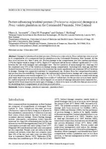
Methods The 28 wetlands of international conservation importance were studied based on their designation as both Ramsar sites (Ramsar 2015, Ramsar Convention Bureau 2002, Fig. 1) and as Important Bird Areas (www.birdlife.org; n = 24) and sites, exclusively designated as IBA (Fishpool and Evans 2001; n = 4; Fig. 1). Four of these wetlands are located in the Atlas Mountains at an altitude of 1462–2300 m (3 are located in protected areas within the Middle Atlas mountains and 1 within the High Atlas mountains), six in inland areas from 100 to 356 m, five in Saharan zones and the others are coastal wetlands.
Species Richness Data Given that the phenology of breeding waterbirds species is overall similar (Thévenot et al. Thèvenot et al. 2003), surveys of all designated wetlands were conducted in 2012 during the peak of breeding activity in May and June. Species abundances were not taken into account because of limited human resources, shortness of the survey period and the large distances between studied wetlands. Analyses were based on presence/absence of 15 species belonging to Anseriformes, Podicipediformes and Ralliformes (Table 1). Proof of breeding for each species was confirmed by one of the following: (i) nest construction activity; (ii) presence of active nest; (iii) nest attendance by adults and (iv) presence of chicks nearby the adults or on their backs or the behavioural breeding criteria: (v) nuptial display (pivoting with necks, bouncy posture, performing Ghostly penguin posture) (Cherkaoui et al. 2014) and (vi) copulation. The Ruddy Shelduck Tadorna ferruginea is a cavity-nesting duck (Thévenot et al. Thèvenot et al. 2003) so criteria (i), (ii) and (iii) were not appropriate for this species. Waterbird surveys were carried out using binoculars and a spotting scope from the shore and from accessible vantage points that cumulatively allowed total surveys of each study wetland. The number of counting points depended on wetland shape and area. The number of observation points per site ranged between 3 and 6. Observations were made between sunrise and midday, and in good weather, ensuring that detection conditions were relatively homogeneous. All data were collected by the same author [I. Cherkaoui (IC)].
Author's personal copy Wetlands (2015) 35:913–922
915
Fig. 1 Geographic location of the 28 Moroccan monitored wetlands. 1: Lower Tahaddart; 2: Lower Loukkos; 3: Plateau Rmel marshes; 4: Merja Zerga; 5: Boughaba; 6: Cap des trois fourches; 7: Sebkha Bou Areg; 8: Moulouya estuary; 9: Mohamed V reservoir; 10: El Maleh marshes; 11: Oualidia lagoon; 12: Massira reservoir; 13: Sebkha Zima; 14: Essaouira; 15: Aguelmame Afennourir; 16: Aguelmame Tifounassine; 17: Islit-Tislit lakes; 18: Tafilelt; 19: Draa; 20: Souss-Massa; 21: Middle Draa; 22: Chbeyka estuary; 23: Khnifiss lagoon; 24: Dakhla lagoon; 25: Dayet Aoua; 26: Oum Fatma estuary; 27: Laayoun marshes; 28 Mansour Eddahbi reservoir
Table 1 Breeding species of studied waterbirds in Moroccan IBA and Ramsar wetlands
Order
Families
Anserifomes
Anatidae
Podicipediformes
Ruddy Shelduck Gadwall Mallard Marbled Teal Red-crested Pochard Common Pochard Ferruginous Duck White-headed Duck Podicipedidae Little Grebe Great Crested Grebe Black-necked Grebe Rallidae Purple Swamphen Common Moorhen Red-knobbed Coot Eurasian Coot
Ralliformes
Common name
Species name
Status
Tadorna ferruginea Anas strepera Anas platyrhynchos Marmaronetta angustirostris Netta rufina Aythya ferina Aythya nyroca Oxyura leucocephala
RB RB,WV RB, WV RB, WV, PM RB, WV RB,WV RB, WV RB, AV
Tachybaptus ruficollis Podiceps cristatus Podiceps nigricollis
RB, WV RB, WV RB, WV
Porphyrio porphyria Gallinula chloropus Fulica cristata Fulica atra
RB RB, WV RB RB, WV
WV winter visitor; PM passage migrant; RB resident breeder; AV accidental visitor
Author's personal copy 916
Environmental Data The location of each wetland [latitude (LAT) and longitude (LONG) variables] and its altitude were determined using a global positioning system device (Garmin eTrex HC). We determined: (i) the wetland area (AREA) in hectares from Dakki et al. (2011) for Ramsar sites and from Birdlife datasets (www.birdlife.com) for Important Bird Areas (IBA); (ii) the proportion of the water surface area covered by emergent vegetation (VC) calculated from the Google Maps © by geographic information system Quantum GIS v2.6.1 [(the ratio of vegetation coverage area to the wetland area) × 100] and (iii) the number of species contributing to emergent vegetation (NBH; e.g. Catail Typha sp., Common Reed Phragmites sp., Bulrush Scirpus sp., Rushes Juncus sp. and Tamaris sp.) was checked during fieldwork by walking randomly within vegetated areas. In the case of smaller wetlands, we were able to determine this number from the shore.
Statistical Analysis Prior to statistical analysis, we checked for normality and homogeneity of variance of all the variables. Variables that did not conform to the requirements for parametric tests were log (the case of the altitude and area) or square root (% vegetation cover) transformed prior to all analyses (Zar 1984; Underwood 1994; Quinn and Keough 2002). Regression models are generally assumed robust to multicollinearity if the Pearson’s Rank correlation between variables is less than r = |0.6| (Mertler and Vannatta 2002) so we excluded any such correlated variables from contributing to the same models. After this initial analysis, we modelled species richness separately for the four subgroups as a function of geographical, topographical and macrohabitat variables. Three wetlands (Cap des trois fourches, Dakhla bay and Ouma Fatma) were excluded from the analysis because we found no breeding waterbird species. We built all possible Generalized Linear Models (GLM) combinations with Gaussian error and identity link-function, including a null model with intercept only. We ranked models according to their ΔAICc values, correcting AIC for small sample size (n = 25, Burnham and Anderson 2002) and used the model with the lowest AICc together with the associated weight value (the probability that a given model is the best) as that best described the data. We all considered models with ΔAICc lower than 2 as equally good (Burnham and Anderson 2002) and used model averaging to generate estimates of function slopes for parameters of interest (Burnham and Anderson 2002). Model weights were used to define the relative importance of each explanatory variable across the full set of models evaluated by summing weight values of all models that included the explanatory variable of interest.
Wetlands (2015) 35:913–922
One of the assumptions of parametric statistics is that observations are independent of each other. This assumption is often violated with spatial data, so it is important to test for and, where present, subsequently address spatial autocorrelation in data prior to data analysis. The presence of spatial autocorrelation was tested using semi-variograms of the residuals of the best model in terms of AIC value. When spatial autocorrelation was encountered, we used alternative models including autoregressive models [(Conditional A u t o r eg r es s i v e M o d e l (C A R ) a n d S i m u l t a n e ou s Autoregressive Model (SAR)]. By accounting for spatial autocorrelation, the effects estimated by the SAR and the CAR models may reflect local effects to a greater extent, while effects estimated by the ordinary least squares models may reflect broad-scale patterns to a greater degree (Dormann et al. 2007). To assess whether the residuals of the best model were normally distributed, and thus acceptable, we used the Shapiro–Wilk test (p > 0.05 for all models). We conducted all statistical analyses in the statistical programming language environment R-3.1.2 software (R Development Core Team 2014). We used the packages “sp”, “lattice” and “gstat” to draw semivariograms (Pebesma 2006), the package “spdep” to fit autoregressive models (Bivand et al. 2012) and the package “MuMIn” to estimate model-averaging parameters (Bartoń 2013).
Results A total of 15 waterbird breeding species were recorded all 15 sites combined. The maximum number of waterbird species observed at any one a site was 13 (range: 2–13), while those of Anatidae, Podicipedidae and Rallidae were 7 (0–7), 2 (1–2) and 4 (1–4) respectively. Model selection based on ΔAICc showed that one model adequately explained the overall waterbird species richness which explained 68 % of variation (Table 2). Explanatory variables that contributed to this model were the number of emergent vegetation species (β = 4.893 ± 1.258, 95 % CI: 2.427–7.359, Fig. 2a3), altitude (β = 0.899 ± 0.235, 95 % CI: 0.438–1.359, Fig. 2a 1) and % vegetation coverage (β = 0.754 ± 0.245, 95 % CI: 0.274–1.235, Fig. 2a2). The best model based on ΔAICc explained 56 % of variation in Anadidae species richness and included the number of emergent vegetation species (β = 0.604 ± 0.263, 95 % CI: 0.089– 1.12, Fig. 2b3), altitude (β = 0.134 ± 0.049, 95 % CI: 0.038– 0.231, Fig. 2b1) and % vegetation coverage (β = 0.160 ± 0.051, 95 % CI: 0.059–0.26, Fig. 2b2). Model selection based on ΔAICc showed that three models explaining Rallidae species richness were equally good (Table 2). The best models explained 59.6–64.5 % of variation in Rallidae species richness (Table 2). Explanatory variables
Author's personal copy Wetlands (2015) 35:913–922
917
Table 2 Best models describing species richness of breeding overall waterbirds, Anatidae, Rallidae, and Podicipedidae in Moroccan IBA and Ramsar wetlands K
R2
AICc
ΔAICc
Weight
ALT + VC + NBH LAT + ALT + VC + NBH
4 5
0.678 0.691
109.911 112.409
0.000 2.498
0.499 0.143
ALT + AREA + VC + NBH
5
0.682
113.152
3.241
0.099
LAT + AREA + VC
4
0.607
114.913
5.002
0.041
LAT + ALT + AREA + VC + NBH LAT + AREA + NBH
6 4
0.703 0.600
115.339 115.340
5.428 5.429
0.033 0.033
5
0.644
Model Overall waterbirds species richness
LAT + AREA + VC + NBH
115.954
6.043
0.024
129.650
19.739
0.000
0.561 0.451
31.640 34.092
0.000 2.452
0.332 0.098
3
0.441
34.557
2.916
0.077
2 5
0.370 0.564
34.680 34.977
3.040 3.337
0.073 0.063
ALT + AREA + VC + NBH LAT + ALT + VC LAT + AREA + VC
5 4 4
0.562 0.483 0.479
35.106 35.762 35.964
3.466 4.121 4.323
0.059 0.042 0.038
VC + NBH AREA + VC LAT + VC + NBH ALT + AREA + VC
3 3 4 4
0.405 0.402 0.460 0.459
36.109 36.239 36.825 36.874
4.469 4.599 5.184 5.233
0.036 0.033 0.025 0.024
ALT + NBH Null model Rallidae species richness LAT + NBH LAT + VC + NBH
3 1
0.358
38.007 43.63
6.367 11.99
0.014 0.002
3 4
0.616 0.645
53.186 54.376
0.000 1.190
0.258 0.142
LAT + VC LAT + AREA + NBH LAT + ALT + NBH LAT LAT + ALT + VC + NBH AREA + VC + NBH LAT + ALT + VC LAT + AREA + VC + NBH LAT + AREA NBH LAT + ALT VC + NBH ALT + VC + NBH LAT + ALT + AREA + NBH
3 4 4 2 5 4 4 5 3 2 3 3 4 5
0.596 0.623 0.622 0.505 0.659 0.605 0.596 0.648 0.537 0.469 0.524 0.517 0.570 0.625
54.459 55.876 55.943 56.662 56.886 57.026 57.610 57.668 57.877 58.415 58.556 58.937 59.147 59.248
1.273 2.690 2.757 3.476 3.700 3.840 4.424 4.481 4.691 5.229 5.370 5.750 5.961 6.062
0.137 0.032 0.031 0.022 0.019 0.018 0.013 0.013 0.012 0.009 0.008 0.007 0.006 0.006
Null model Podicipedidae species richness LAT + ALT + AREA LAT + ALT + AREA + NBH LAT + ALT + NBH LAT + ALT + VC + AREA ALT + NBH
1
71.65
18.464
0.000
39.810 41.621 42.251 42.640 43.430
0.000 1.810 2.440 2.830 3.619
0.369 0.149 0.109 0.090 0.060
Null model Anatidae species richness
1
ALT + VC + NBH ALT + VC
4 3
LAT + VC VC LAT + ALT + VC + NBH
4 5 4 5 3
0.674 0.695 0.641 0.683 0.573
Author's personal copy 918
Wetlands (2015) 35:913–922
Table 2 (continued) K
R2
AICc
ΔAICc
Weight
LAT + ALT + VC + NBH
5
0.663
44.160
4.349
0.042
LAT + ALT + VC LAT + ALT
4 3
0.611 0.550
44.234 44.731
4.423 4.921
0.040 0.032
ALT + AREA + NBH LAT + ALT +VC
4 4
0.601 0.600
44.840 44.932
5.029 5.121
0.030 0.028
LAT + ALT + AREA + VC + NBH ALT + AREA + VC + NBH
6 5
0.702 0.626
45.004 46.733
5.194 6.923
0.027 0.012
Null model
1
59.22
19.41
0.000
Model
LAT latitude, ALT altitude, AREA wetland area, VC vegetation coverage, NBH number of emergent vegetation species
that were present in the best models (betas, SE and 95 % CI given in brackets are model-averaged estimates across all possible models) were latitude (β = 0.186 ± 0.061, 95 % CI: 0.067–0.305, importance =0.928, Fig. 2c1), number of emergent vegetation species (β = 0.985 ± 0.331, 95 % CI: 0.336–
1.634, importance =0.690, Fig. 2c2) and % vegetation coverage (β = 0.136 ± 0.039, 95 % CI: 0.059–0.213, importance =0.461). For the Podicipedidae, the best models explained 67.4–69.5 % of variation in species richness. Explanatory variables that were present in the best models were latitude,
Fig. 2 Factors affecting overall waterbirds (A1-A3), Anatidae (B1-B3), Rallidae (C1-C2) and Podicipedidae (D) species richness in Moroccan Ramsar and IBA wetlands
Author's personal copy Wetlands (2015) 35:913–922
919
altitude and wetland area (Table 2). The semi variogram, established from the residuals of the best model, indicates a spatial pattern in the data (nugget =0.06; partial sill =0.19). Indeed, the nugget-to-sill ratio (nugget/nugget + partial sill) was 0.24, which indicates the presence of strong spatial dependence (