www.nature.com/scientificreports
OPEN
Received: 15 December 2016 Accepted: 15 May 2017 Published: xx xx xxxx
From shifting cultivation to teak plantation: effect on overland flow and sediment yield in a montane tropical catchment Olivier Ribolzi1, Olivier Evrard 2, Sylvain Huon3, Anneke de Rouw4, Norbert Silvera5, Keo Oudone Latsachack6, Bounsamai Soulileuth6, Irène Lefèvre2, Alain Pierret5,6, Guillaume Lacombe7, Oloth Sengtaheuanghoung8 & Christian Valentin5 Soil erosion supplies large quantities of sediments to rivers of Southeastern Asia. It reduces soil fertility of agro-ecosystems located on hillslopes, and it degrades, downstream, water resource quality and leads to the siltation of reservoirs. An increase in the surface area covered with commercial perennial monocultures such as teak plantations is currently observed at the expanse of traditional slash-andburn cultivation systems in steep montane environments of these regions. The impacts of land-use change on the hydrological response and sediment yields have been investigated in a representative catchment of Laos monitored for 13 years. After the gradual conversion of rice-based shifting cultivation to teak plantation-based systems, overland flow contribution to stream flow increased from 16 to 31% and sediment yield raised from 98 to 609 Mg km−2. This result is explained by the higher kinetic energy of raindrops falling from the canopy, the virtual absence of understorey vegetation cover to dissipate drop energy and the formation of an impermeable surface crust accelerating the formation and concentration of overland flow. The 25-to-50% lower 137Cs activities measured in soils collected under mature teak plantations compared to soils under other land uses illustrate the severity of soil erosion processes occurring in teak plantations. Soil erosion is exacerbated by the intensification of agriculture in montane steep cultivated catchments of Southeastern Asia, where it delivers significant quantities of sediment to rivers1. This excessive sediment supply leads to water reservoir siltation2 and transports particle-bound contaminants towards downstream areas3–5. Among these pollutants, there are growing concerns regarding the transport of persistent pathogenic bacteria with sediment and their development in the streambed of tropical catchments6, where the use of unclean stream water is associated with a high number of fatal and debilitating diseases7. The impact of land-use change on soil erosion has been investigated in various regions of Southeastern Asia8, although most studies were restricted to the plot and hillslope scales9, 10. The main factors known to control soil erosion at the plot scale1, 11 are rainfall, overland flow and surface characteristics (e.g. land use, vegetation cover, slope gradient, slope length, surface crusting). At this scale, inter-rill erosion processes dominate and mainly detach and mobilize soil surface particles. Then, at the hillslope scale, inter-rill erosion is combined with overland flow, which may concentrate and form rills and gullies, thereby removing and transporting additional particles originating from the soil subsurface12–14. Finally, at the catchment scale, the dominance of overland flow as the 1
Institut de Recherche pour le Développement (IRD), Géosciences Environnement Toulouse (GET), UMR 5563 (CNRSUPS-IRD), Toulouse, France. 2Laboratoire des Sciences du Climat et de l’Environnement (LSCE/IPSL), Unité Mixte de Recherche 8212 (CEA-CNRS-UVSQ), Université Paris-Saclay, Gif-sur-Yvette, France. 3Université Pierre et Marie Curie (UPMC), UMR 7618 iEES (UPMC-CNRS-IRD-INRA-Université Paris 7-UPEC), Paris, France. 4Institut de Recherche pour le Développement (IRD), UMR 7618 iEES (UPMC-CNRS-IRD-INRA-Université Paris 7-UPEC), Paris, France. 5 Institut de Recherche pour le Développement (IRD), iEES-Paris, Centre IRD France-Nord, Bondy, France. 6Institut de Recherche pour le Développement (IRD), Department of Agricultural Land Management (DALaM), Vientiane, Lao PDR. 7International Water Management Institute (IWMI), Southeast Asia Regional Office, Vientiane, Lao PDR. 8 Department of Agricultural Land Management (DALaM), Ministry of Agriculture and Forestry , Vientiane, Lao PDR. Correspondence and requests for materials should be addressed to O.R. (email:
[email protected]) Scientific Reports | 7: 3987 | DOI:10.1038/s41598-017-04385-2
1
www.nature.com/scientificreports/
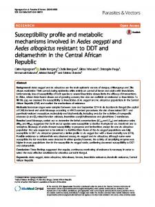
Figure 1. Monitoring devices and sampling sites in the Houay Pano catchment. This original map was created using Surfer 13.2.438 from Golden Software, LLC.
main supply of sediment export at the outlet needs to be more thoroughly investigated, as this phenomenon is in competition with other processes (e.g. reinfiltration and sedimentation, subsurface flow contribution). Although the direct measurement of overland flow is possible at the plot and hillslope scales, it is difficult to carry out similar measurements at the catchment scale. At this larger scale, indirect tracer-based approaches provide an effective method to calculate the respective contributions of subsurface and surface flow. Typically, water mixing models using geochemical properties (e.g. electric conductivity, δ18O) are applied to quantify these contributions15, 16. In forested catchments, subsurface contributions were shown to provide the dominant contribution to streamflow17, 18, whereas surface overland flow was identified as the main supply in cultivated catchments where an almost impermeable crust may be formed at the soil surface15, 19, 20. Most land-use change studies investigated the conversion of forests into cropland, showing the associated increase in soil erosion21, 22. To our knowledge, only few studies have been conducted on the conversion of annual crops into commercial tree monoculture plantations on the steep hillslopes of humid tropics although this rapid land-use change is affecting extensive areas across this region23. The main objective associated with the reforestation of degraded land is often to restore the soil infiltration capacity and to limit soil erosion. However, it was shown that this reforestation may also increase plant water uptake and consequently reduce river baseflow24, 25. To investigate the impact of land-use change on sediment yield, the monitoring of paired catchments is often conducted in nearby sites where contrasted land uses prevail while biophysical characteristics are as similar as possible. This synchronic approach suffers from several limitations because of the difficulty to select two perfectly identical catchments26. In contrast, this approach is easier to conduct in similar zero-order headwater catchments (i.e. hollow valleys referred to as S7 and S8) with similar soil characteristics although different land uses. In addition to this synchronic approach, we applied a diachronic investigation in the larger catchment affected by land use change and draining these hollow valleys. The 0.6-km² Houay Pano catchment (Fig. 1), located in Northern Laos, is representative of areas that experienced large-scale afforestation with commercial teak tree (Tectona grandis L.f.) plantations at the expense of traditional slash-and-burn (i.e. shifting) cultivation. Discharge and sediment yield were monitored for 13 years in this experimental catchment. The contributions of surface (i.e. overland flow) and sub-surface flow (i.e. groundwater) to river water at the catchment outlet were assessed by measuring the river water electrical conductivity. This technique is easier to implement than the more conventional method based on δ18O, and both techniques were found to provide similar results15. The contributions of surface and sub-surface soil sources to stream sediment exports at the catchment outlet were discriminated by measuring the activity of Caesium-137 (137Cs) emitted by thermonuclear bomb tests in the 1960s in the sediment transiting the river27. This radioisotope characterised by a half-life of 30 years shows highly contrasting activities between the surface of cultivated soils exposed to atmospheric fallout and gully/ channel bank material sheltered from this fallout28–30.
Scientific Reports | 7: 3987 | DOI:10.1038/s41598-017-04385-2
2
www.nature.com/scientificreports/
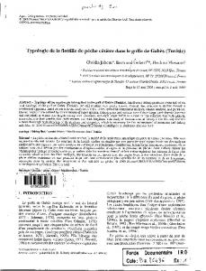
Figure 2. Annual hydro-sedimentary and land-use changes in Houay Pano catchment: (a) Total rainfall depth (Rain), flood-triggering rainfall depth (Rain_F) and total stream flow depth (Runoff); (b) Areal percentages of the catchment covered by the main land uses (i.e. annual crops; annual crops associated with one-or-two-yearsold teak trees; teak plantations; fallow; secondary forest and other land uses including gardens and banana); (c) Box plots (25th and 75th percentiles and median) of infiltration rates computed for each flood event; (d) Box plots of overland flow contribution to total depth of flood events estimated using tracer-based hydrograph separation; (e) Annual sediment yield including suspended load and bed load contributions. This graph was created using Grapher 4.0 from Golden Software, LLC.
Results
Land-use change. The proportion of secondary forests in the catchment decreased from 16% (2002) to 8% (2014) (Fig. 2b). During this period, the variations in the respective proportions of fallow (29–69%) and annual crops (4–42%) were negatively correlated and they showed large inter-annual variations, reflecting the management strategies of replacing fallows with annual crops through slash-and-burn, followed by the regrowth of vegetation in the temporarily abandoned cultivated fields. This entire cycle may take 2 to 6 years (Fig. 2b). Until 2007, the percentage of catchment area covered with teak plantations (Teak) remained low and did not exceed 4%. From 2008, it continuously increased, almost linearly, to reach a maximum of 36% of the catchment area in 2014 (Fig. 2b), illustrating the transition from an annual crop-based system towards an organisation dominated by tree plantations. Accordingly, the monitoring period was divided into a first sub-period (2002–2007) characterized by the alternation between upland rice (Oryza sativa L.), Job’s tear (Coix lacryma-jobi L.) annual crops and bush fallow, in addition to sparse teak plantations, and a second sub-period (2008–2014) characterised by the concomitant expansion of teak plantations and the reduction of annual crops. During the last five years of this second sub-period, most of the teak plantations were more than 3 years old and characterised by limited understorey vegetation cover, which may enhance soil degradation. In 2014, land use greatly differed between the two hollow valleys investigated in details (Fig. 1b), with a dominant contribution of typical shifting cultivation landscape mosaics at S7 compared to a major contribution of teak plantations at S8. Rainfall and runoff. During the 2002–2014 monitoring period of the Houay Pano catchment, annual rainfall
depth (Rain) varied between 978 mm (2012) and 1884 mm (2011), with a mean of 1271 mm (SD: 271 mm, CV: 20%) (Fig. 2a). These values are similar to those recorded at the closest reference weather station located in Luang Prabang (58-year long-term mean: 1302 mm; SD: 364 mm; CV: 28%). Only 32% of the rainfall events generated stormflow (i.e. total stream flow during a flood that is calculated when summing surface and subsurface contributions). The mean annual depth corresponding to these flood-triggering rainfall events (Rain_F) was 404 mm (SD: 118 mm; CV: 28%). Annual runoff showed large inter-annual variations (SD: 52 mm; CV: 67%; mean: 77 mm; range: 13–174 mm) (Fig. 2a). In 2014, runoff from the hollow valleys strongly differed (Friedman non-parametric test for paired samples [α = 0.0001] p 3 was used in order to exclude the youngest plantations which were not yet submitted to burning (Fig. 4a), and in which soils were not yet degraded. Contrary to the total annual overland flow depth (OLF), which is correlated to Rain (p-value 3 (p-value