pale brown to light-yellowish-brown clast-supported cobble gravel whose thickness is unknown, but probably exceeds 5 m. Unit colors were identified.
UNITED STATES DEPARTMENT OF THE INTERIOR GEOLOGICAL SURVEY
Geology of the Pontiac Pit Archeological Site Rocky Mountain National Park, Colorado
By
Richard F. Madole 1
Open-File Report 84-223
This report is preliminary and has not been reviewed for conformity with U.S. Geological Survey editorial standards and stratigraphic nomenclature.
Geological Survey, Denver, Colorado
1984
CONTENTS Page Introduction.............................................................
1
Location and geologic setting of the Pontiac Pit archeological site......
1
Stratigraphy.............................................................
3
Soil-horizon nomenclature................................................
10
Soil description.........................................................
12
References cited.........................................................
15
ILLUSTRATIONS Figure 1. 2.
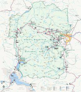
Map showing the location of the Pontiac Pit site..............
2
Sketch showing the stratigraphy at the Pontiac Pit site and the relationship between stratigraphic units and soil horizons...........................................
4
TABLE Table 1.
Laboratory data for the soil profile at the Pontiac Pit site...
5
GEOLOGY OF THE PONTIAC PIT ARCHEOLOGICAL SITE ROCKY MOUNTAIN NATIONAL PARK, COLORADO By Richard F. Madole INTRODUCTION
The geology of the Pontiac Pit archeological site, located in the upper valley of the Colorado River in Rocky Mountain National Park, was studied in support of archeological project ROMO 160 supervised by James W. Mueller and Terri L. Liestman of the National Park Service. The purpose of the study was to determine the age and origin of the stratigraphic units present and the nature of the soil developed at the Pontiac Pit site. LOCATION AND GEOLOGIC SETTING OF THE PONTIAC PIT SITE The Pontiac Pit site is on a terrace that lies about 5 m above the east edge of the flood plain of the Colorado River, a little more than 8 km north of Grand Lake, Colo. (fig. 1). The site is near the center of sec. 12, T. 4 N., R. 76 W., a few tens of meters east of Trail Ridge Road (U.S. Highway 34) and about 100 m north of a borrow pit, known locally as Pontiac pit. The terrace is composed chiefly of stratified drift of glaciofluvial origin . Two other terrace remnants are present nearby at slightly higher levels. The uppermost of these is the site of Pontiac pit. The Pontiac Pit site is within the area in this valley that was glaciated during Pinedale time (approximately 30,000-13,500 B.P.). It lies about 8 km upvalley from the terminal moraine of Pinedale age (fig. 1), and about 18 km downvalley from where the Continental Divide crosses La Poudre Pass at the head of the Colorado River. Although concerned primarily with evaluating relative-dating methods, Meierding (1977) shows the distribution of glacial and glaciofluvial deposits in part of the upper Colorado River basin, including the area of the Pontiac Pit site. STRATIGRAPHY
Four stratigraphic units are present at the Pontiac Pit site (fig. 2). These include from top to bottom (1) dark-grayish-brown to very dark gray silty sand (nearly sandy silt), 3-5 cm thick in most places; (2) brown to dark-brown silty sand, commonly 9-12 cm thick; (3) yellowish-brown to darkyellowish-brown matrix-supported pebble gravel, 5-10 cm thick; and (4) very pale brown to light-yellowish-brown clast-supported cobble gravel whose thickness is unknown, but probably exceeds 5 m. Unit colors were identified from Munsell Soil Color Charts, and unit textures are according to Shepard's (1954) textural classification of sediments. The range of color listed for each unit represents the range seen in dry to moist sediment.
108
40°-
Approximate positions of terminal moraines of Pinedate age I
Figure 1. Map showing the location of the Pontiac Pit site Unit 1 Dark-grayish-brown to very dark gray silty sand (latest Holocene). Unit 1 is commonly 3-5 cm thick, but is thicker locally* It mantles the ground surface and overlies an older eolian unit from which it differs texturally in being more silty (table 1). The contact between units 1 and 2 is indistinct because the color of the 2A horizon 1 (fig. 2) developed in unit 2 is only slightly lighter than that of the A horizon developed in unit 1. Initially, the 2A horizon was interpreted to be an incipient E horizon because of this slight difference in color compared with the A horizon. Unit 1 is believed to be of eolian origin and less than about 800 years old. The interpretation of origin is based mainly on the high percentage of silt in this unit (table 1) and the general absence of particles larger than sand (see soil description). The age assigned to unit 1 is based on the age of the archeological features that underlie it. Unit 1 is younger that about 800 B.P., because it overlies four hearths whose radiocarbon ages range from 780 ± 50 to 980 ± 180 yrs B.P. (T. L. Liestman, written commun., 1984).
soil-horizon nomenclature used in this report follows that proposed for the new Soil Survey Manual, Chapter 4, which has not been published yet, but has-been summarized by Guthrie and Witty (1982). A few symbols and definitions from Birkeland (1974) are used also.
Strotigraphic Units
Figure 2. Sketch showing the stratigraphy at the Pontiac Pit site and the relationship between stratigraphic units and mineral soil horizons. The color B horizon (Bw) is formed partly in eolian sediment and partly in gravel, and is similar in degree of development to B horizons formed in deposits of Pinedale age in other localities in the Front Range. The A horizon is formed in eolian sediment that is much younger than that in which the rest of the soil is developed. Each stratigraphic unit (the four parent materials identified by Arabic numeral prefixes) is texturally distinct (table 1). Unit 2 Brown to dark-brown silty sand (late Pleistocene (?) and Holocene). Unit 2 is typically 9-12 cm thick, and it is texturally distinct from the units above and below (table 1). Although minor amounts of windblown sediment may have been added to this unit periodically over a long interval, most of the unit is believed to be older than about 5900 B.P., and possibly is as old or older than 10,000 B.P. The degree of development of the B horizon, which extends from the lower part of unit 2 into unit 3 (fig. 2), suggests that unit 2 is as old as late Pleistocene or early Holocene. The development of the B horizon is similar to B horizons formed in deposits of Pinedale age in other localities in the Front Range, and the colors of the Bw and Cox horizons are like those of soils in both the Middle and Southern Rocky Mountains that are 10,000 years old (Shroba and Birkeland, 1983, p. 148). Furthermore, a considerable amount of loess was deposited in this region between 14,000 and 10,000 years ago (Madole, 1976, 1980, and unpub. data), and unit 2 might be correlative with this loess.
A variety of artifactual remains and features provide a minimum age for unit 2 (archeological data and related radiocarbon ages are from T. L. Liestman, written commun., 1984). A projectile point of the Middle Plains Archaic period (4500-3000 B.P.) was found at or near the surface of unit 2. Charcoal from several hearths ranging in age from a little more than 2000 B.P. to more than 4,000 B.P. were excavated in this unit. One hearth, dated at 3920 ± 160 yrs B.P. (Beta-7202), clearly postdates deposition of the lower part of unit 2, and a similar feature with an age of 4710 ±110 yrs B.P. (Beta-6882), but whose stratigraphic relations are less clear, also probably postdates unit 2. Fragments of two projectile points similar to those associated with the Mount Albion complex (about 5300-5900 B.P.) of Benedict and Olsen (1978) were found in two locations at the Pontiac Pit site. Unfortunately, the stratigraphic positions of the two fragments relative to the upper and lower contacts of unit 2 are uncertain. Nonetheless, no reason exists to believe that they predate unit 2. This plus their similarity to projectile points of the Mount Albion complex is the basis for the minimum age of 5900 B.P. listed above. Unit 3 Yellowish-brown to dark-yellowish-brown matrix-supported pebble gravel (late Pleistocene). Unit 3 is a matrix-supported pebble gravel,5-10 cm thick, that overlies the clast-supported cobble gravel that composes most of the deposit underlying the terrace surface (fig. 2). Unit 3 is interpreted to be a mixture of eolian sediment and/or sheetwash containing gravel reworked from unit 4. Matrix supported refers to the fact that matrix (the fraction less than 2 mm in size) is dominant, and clasts (mostly pebbles in this unit) are separated from each other by matrix, as opposed to a clast-supported gravel, wherein clasts are nearly in continuous contact and matrix is subordinate. The areal extent and significance of the matrix-supported pebble gravel is unknown. It could represent localized disturbance that mixed gravel and eolian sediment, as for example from wind-thrown trees, or it could be due to processes such as frost heave or sheetwash that affected a more extensive area. Without more information, I favor either an origin by frost heave or reworking by sheetwash. This sediment may have been deposited soon after that of unit 4, or it may have accumulated slowly or intermittently throughout the time between deposition of units 4 and 2. Unit 4 Very pale brown to light-yellowish-brown cobble gravel (late Pleistocene). Unit 4 was examined in a pit excavated adjacent to the Pontias Pit site. Although the pit was excavated to a depth of only 60 cm, the sediment observed in it is like that in larger exposures in similar deposits elsewhere in the area; hence, it is presumed to be representative of the terrace deposit as a whole. The deposit is of glaciofluvial origin. Smallto medium-sized cobbles dominate, and only a small percentage of clasts are as large as 15 cm in maximum dimension. Most of the clasts are well-rounded fragments of igneous and metamorphic rocks. The deposit is poorly consolidated and contains so little silt and clay that the walls of the soil pit caved in readily. Medium sand is the dominant size fraction present in the matrix (table 1). The deposit is believed to be at least as thick as the terrace is high, which is about 5 m.
2.5
79.4
96.4
14-21 21-60+
3Bw 4 Cox 17.5
13.8
13.1
8.1 12.4
Very coarse (2-1)
26.5
18.5
13.6
10.5 14.1
(1-0.5)
Coarse
27.0 41.9
17.6
12.0 15.7
Medium (0.50.25)
7.7
13.1
10.1
7.5 8.4
Fine (0.250.10)
Particle-size distribution determined by the sieve-pipette method.
1.1
8.4
16.9
16.4
16.6
«0.002)
Clay3
Sand
2.9
7.1
7.5
6.7 5.9
Very fine (0.100.05)
1.1
3.1
5.1
12.6 6.2
Coarse (0.050.03)
0.6
2.6
5.6
7.4 7.4
Medium (0.030.02)
Silt
0.8
6.5
10.6
18.7 13.4
Fine (0.020.002)
0.3
4.0
5.2
6.2
7.1
0.8
4.5
11.7
9.5 10.3
Particle-size limits for silt and clay are according to the the U.S. Department of Agriculture particle-size scale (Soil
Survey Staff, 1975).
Q
Clay Coarse Fine (0.0020.0005) «0.0005)
^See the section on soil-horizon nomenclature for an explanation of the soil-horizon designations used here.
n
12.2
61.8
11-14
2Bw
21.3
56.5
38.7 27.0
44.8
Silt 3 (0.050.002)
0-4
Average Sand depth (2-0.05) (cm)
4-11
o
A 2A
Horizon
Total
Particle-size distribution (mm) 1 Percentage of