av syrekontaminering av proverna under provtagning och/eller mätning. Avsaknaden av sulfat i kombination med rådande redoxförhållanden visar att oxidation ...
Investigation of the redox-conditions in the Nam Du well field, Hanoi, Vietnam, and their implications for mobilisation of Arsenic Johanna Moreskog
Handledare:
Assoc Prof Dr Pham Quy Nhan (Dept of Hydrogeology, Hanoi University of Mining and Geology) Dr Jenny Norrman (Dept of Environmental Engineering, Swedish Geotechnical Institute, Göteborg)
Examinator:
Prof Dan Berggren Kleja (Dept of Soil Sciences, SLU)
KANDIDATARBETE I MARKVETENSKAP, 15 hp __________________________________________________________________ Sveriges lantbruksuniversitet Institutionen för markvetenskap Avdelningen för markkemi och jordmånslära Examens- och seminariearbeten Nr 83
Uppsala 2007 ISSN 1102-1381 ISRN SLU-MLE-EXS--83--SE
Abstract In 2005, a new well field along the Red River started pumping groundwater for production of drinking water in the Nam Du area south of Hanoi, Vietnam. Elevated concentrations of ammonium have been a well-known problem in the southern part of Hanoi area, but recently elevated concentrations of arsenic in the groundwater has also been of concern. The first study on elevated concentrations of arsenic in the Red River delta was published in 2001 (Berg et al., 2001). Peat has been discussed as a source for both ammonium and as a driver for the mobilisation of arsenic and this study aims to investigate the possible relationship between arsenic, ammonium, the peat and the redox conditions. Chemical analyses from this study resulted in total arsenic concentrations from 27 to 312 µg/l in the groundwater samples, which can be compared to the health-based guideline of 10 µg/l. Most of the arsenic in the groundwater is present as arsenite, the more toxic specie of arsenic. The analyses also showed elevated concentrations of ammonium in the groundwater ranging from 1.8 to 34.7 mg/l. The relationships between the different redox couples were studied with Visual Minteq, which showed that the redox potentials measured in the field were a little bit higher than expected from the model. This can probably be explained by contamination of oxygen during sampling and/or measurement. The lack of sulphate in combination with the present redox conditions indicated that oxidation of arsenic bearing sulphurous minerals is not likely to be the main source of arsenic. Instead, the relationship between arsenic and HCO3, indicates that a more probable source of the arsenic would be reductive dissolution of iron oxyhydroxides.
i
Sammanfattning Hösten 2005 började man pumpa grundvatten från ett nytt brunnsfält i Nam Du-området längs Röda floden strax söder om Hanoi för dricksvattenproduktion. Förhöjda halter av ammonium är sedan länge ett känt problem i grundvattnet söder om Hanoi men på senare år har även förhöjda halter av arsenik i grundvattnet gett anledning till oro. År 2001 publicerades den första studien som visade på förhöjda halter av arsenik i Röda flodendeltat (Berg et al., 2001). Torv har diskuterats som både en källa till ammoniumet och som en pådrivande faktor för mobiliseringen av arsenik. Syftet med den här studien har varit att undersöka ett möjligt samband mellan arsenik, ammonium, torven och redox-förhållandena. Kemiska analyser av grundvattnet visade på arsenikhalter mellan 27 och 312 µg/l, vilket är långt över de riktvärden som finns för dricksvatten (10 µg/l) både i Vietnam och som WHO rekommenderar. Till största delen förekommer arseniken som arsenit, vilket är den mer toxiska jonformen av arsenik. Analyser visade även på förhöjda halter av ammonium i grundvatten, med halter från 1,8 till 34,7 mg/l. Sambandet mellan de olika redoxparen studerades med hjälp av Visual Minteq, som visade att den i fält uppmätta redoxpotentialen var något högre än vad som kunde förväntas utifrån modellen. Detta kan troligtvis förklaras av syrekontaminering av proverna under provtagning och/eller mätning. Avsaknaden av sulfat i kombination med rådande redoxförhållanden visar att oxidation av svavelinnehållande mineral inte är en trolig källa för arseniken. Istället indikerar sambandet mellan As och HCO3 att reduktion av järnhydroxider är en mer trolig källa till arseniken.
ii
Tóm tắt
iii
Preface by the supervisors High concentrations of arsenic in groundwater have been reported from different regions in the world. Well-known high-As groundwater areas have been found in Argentina, Chile, Mexico, China and Hungary, and more recently in the densely populated river deltas in S and SE Asia which contain large groundwater aquifers: West Bengal (India), Bangladesh and Vietnam. The most common cause of the high-As groundwater in these regions is due to natural occurrence of arsenic in the sediments and the right conditions for arsenic mobilisation. The first publication on arsenic contamination of the aquifers in the densely populated Red River delta was published in 2001. Consequently, in recent years, a major concern regarding the arsenic concentration in the groundwater in the Red River delta has arisen. The process for mobilisation of arsenic in the Red River delta aquifers is believed to be due to the natural conditions. However, in order to manage the groundwater quality in the future, a deeper understanding of the prevailing conditions and the on-going processes is needed. Furthermore, the Hanoi aquifers in the Red River delta have high and increasing ammonium concentrations, of which the source, so far, have been undetermined. The work presented in this study has been an important part of a current research project at the Swedish Geotechnical Institute (SGI): Sources and distribution of ammonium and arsenic in the Red River delta aquifers (AmonAs). AmonAs is financed by Sida/SAREC during the period 2005 – 2007 and is a co-operation between SGI, the Royal Institute of Technology (KTH) and Hanoi University of Mining and Geology (HUMG) in Vietnam. Johanna Moreskog has made a study in order to investigate a possible relationship between the arsenic, ammonium, the peat and the redox-conditions in the groundwater in Nam Du. The chemical composition of the groundwater was analysed and used for geochemical modelling in order to investigate the redox conditions. By using Visual Minteq, both ion speciation and solubility calculations were performed. An extensive field campaign was carried out in Vietnam during February – March 2006, together with Peter HarmsRingdahl. The results of this study support the current hypothesis that the mobilisation of arsenic is caused by reduction of iron hydroxides. Johanna and Peter planned and carried out the field campaign in a highly independent manner and cooperated effectively with their Vietnamese co-students. Johanna has worked impressively independent with the analyses and the writing of this thesis. She has ambitiously widened the scope of her work and her knowledge during the progress of this study. It has been our pleasure to have the opportunity to work together with her. We wish you all the best in the future! Göteborg 2007-08-16 Jenny Norrman, SGI PhD, supervisor
Håkan Rosqvist, NSR AB PhD, supervisor
iv
Gunnar Jacks, KTH Prof Emeritus, supervisor
Abbreviations Equipment AAS – Atomic Absorptions Spectrophotometry HG-AAS – Hydride Generation Atomic Absorptions Spectrophotometry IC – Ion Chromatograph ICP-MS – Inductivley Coupled Plasma – Mass Spectrometer ICP-OES – Inductively Coupled Plasma – Optical Emission Spectrometer MS – Mass Spectrometer VM – Visual Minteq, Geochemical modelling software Universities, laboratories, institutes etc CETASD – Centre for Environmental Technology and Sustainable Development EAWAG –Swiss Federal Institute of Aquatic Science and Technology HUMG – Hanoi University of Mining and Geology HUS – Hanoi University of Science INST – Institute of Nuclear Science and Technology SGI – Swedish Geotechnical Institute SLU – Swedish Agricultural University SU – Stockholm University UMU – Umeå University WHO – World Health Organisation ÅAU – Åbo Akademi University Codes for sampling sites 1,2,3 – Transect number RGw – Shallow groundwater close to the river SRw – Surface water from the river D – Surface water from ponds P1, P3, P86, ND12 – Monitoring wells PX, PY – Private, small scale production wells ND 3, ND 9 – Big scale production wells
v
Acknowledgements Firstly I’d like to thank, Peter Harms-Ringdahl, my very supportive co-worker during the whole project. The AmonAs project, that financed the field campaign and for all support, especially Jenny Norrman for all help with analysing the results and the writing of the report. Håkan Rosqvist and Gunnar Jacks were of great value for all practical help with starting up the project and support during the field campaign. In field we also had great support from Pham Quay Nhan and Nguyen Thi Thanh Thuy, employees from INST and CETASD. Yvonne Andersson-Sköld from SGI helped me a lot with analysing the results of the geochemical model. It was also of great value for the understanding and evaluation of laboratory anlyses to be able to visit the labs in Vietnam, INST and CETASD, many thanks to the helpful staff at these laboratories. Michael Berg at EAWAG, has also been of great help by kindly answering all questions and analysing our water samples. This Bachelor’s thesis is examined at the Department of Soil Sciences at the Swedish University of Agricultural Science (SLU) and the employees, especially at the Division of Soil Chemistry and Pedology, are gratefully acknowledged for answering questions at all times.
vi
Content Abstract ................................................................................................................................................ i Sammanfattning ................................................................................................................................. ii Tóm tắt ...............................................................................................................................................iii Preface by the supervisors................................................................................................................. iv Abbreviations ...................................................................................................................................... v Acknowledgements ............................................................................................................................ vi Content.............................................................................................................................................. vii 1. Introduction ............................................................................................................................... 1 1.1. Background ....................................................................................................................... 1 1.2. Objectives and scope......................................................................................................... 2 1.3. Outline of the project ........................................................................................................ 3 2. Study area: Nam Du well field .................................................................................................. 4 2.1. Geography and climate ..................................................................................................... 4 2.2. Geology............................................................................................................................. 7 2.3. Hydrogeology ................................................................................................................. 10 2.4. Geological formations and mineral occurrence .............................................................. 12 3. Theory ...................................................................................................................................... 13 3.1. Equilibrium and solubility .............................................................................................. 13 3.2. Redox processes.............................................................................................................. 13 3.3. Arsenic ............................................................................................................................ 16 3.4. Ammonium ..................................................................................................................... 17 4. Methods and materials ............................................................................................................ 19 4.1. Sampling plan and laboratories....................................................................................... 19 4.2. Collection of samples in the field ................................................................................... 21 4.3. Analyses in the field........................................................................................................ 23 4.4. Treatment/handling of samples for laboratory analyses ................................................. 25 4.5. Analyses in laboratory .................................................................................................... 26 5. Results ...................................................................................................................................... 28 5.1. Drilling log...................................................................................................................... 28 5.2. Results from the field analyses ....................................................................................... 28 5.3. Chemical analyses........................................................................................................... 29 5.4. Comparisons between the laboratories ........................................................................... 33 6. Geochemical modelling in Visual Minteq 2.51....................................................................... 34 6.1. Redox and speciation in VM........................................................................................... 34 6.2. Solubility calculations in VM ......................................................................................... 37 7. Discussion ................................................................................................................................ 39 7.1. Redox conditions ............................................................................................................ 39 7.2. Solubility and precipitation of minerals.......................................................................... 39 7.3. Mobilisation process of arsenic....................................................................................... 40 7.4. Ammonium and the origin of DOC ................................................................................ 40 7.5. Mobilisation of arsenic and ammonium.......................................................................... 41 7.6. Health issues ................................................................................................................... 42 7.7. Sources of error............................................................................................................... 42 8. Conclusions.............................................................................................................................. 44 9. Future studies and recommendations..................................................................................... 45 References .............................................................................................................................. 46 Appendix A. Input data for the model in Visual Minteq 2.51 ................................................................. I B. Results from Visual Minteq ............................................................................................ IV
vii
1. Introduction 1.1.
Background
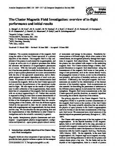
High concentrations of arsenic has earlier been found in aquifers in Bangladesh, Argentina, China, Mexico etc, (WHO, 2001; Smedley and Kinniburgh, 2002; Bhattacharya et al., 2006) and in 2001, Berg et al. published the first report on the high concentrations of As in the Red River delta in northern Vietnam (see Figure 1-1). The average concentration was 159 µg/l and peak values of 3050 µg/l were observed, these values are well above the international limits of arsenic in drinking water set to 10 µg/l by WHO (Berg et al., 2001). In reducing environments, it is typically groundwater in late Quaternary sediments, mainly of Holocene origin, of deltaic and alluvial origin that might contain elevated concentrations of arsenic, which is the situation in both Bangladesh and Vietnam (Berg et al., 2007). It is also suggested by Saunders et al. (2004), that similar aquifers in developed countries also may contain elevated concentrations of arsenic. The reason for this not being noted yet would be the low usage of this type of groundwater due to the high iron content. Even small changes in the environment can mobilise the arsenic, and due to the low guideline, have severe consequences (WHO, 2001).
Figure 1-1. Map of arsenic, ammonium and peat in the area around Hanoi in the Red River delta, Vietnam.
1
The consequence of long-term exposure (10-15 years minimum), of arsenic can be e.g. bladder and skin cancer, black foot disease (WHO, 2001). In a field campaign in 2001, Agusa et al. found levels of arsenic in hair from people in two districts south of Hanoi (Thanh Tri and Gia Lam) that exceeds the levels where symptoms appear (Agusa et al., 2006). Many of the symptoms of chronic arsenic poisoning takes long time to develop, which is why present status of arsenic poisoning just might be the tip of an ice berg (van Geen et al., 2004). Southeast of the city (see Figure 1-1), where some of the highest concentrations were measured, a new well field (Nam Du well field) were built and started producing drinking water in 2005. In the area, also elevated levels of ammonium are previously noted. (Nhan, 2006; Berg et al., 2001) In Bangladesh elevated levels of arsenic is a enormous problem and the conditions are similar to those in Vietnam. Peat is present in the sediments in the Ganges delta in Bangladesh, which is believed to initiate the reductive processes that are causing the mobilisation of arsenic in Bangladesh. Also in the Red River delta in Vietnam, peat layers are present (see Figure 1-1) and, for the same reasons, they are believed to contribute to the mobilisation of arsenic. (Berg et al., 2001; McArthur et al., 2004) Elevated levels of ammonium are normally not found in surface water, since it will oxidise to nitrate. However, elevated levels exceeding the national guidelines are noted south of Hanoi, where the guideline is set to 1.5 mg/l (Nhan, 2006). Andersson and Norrman (1998) suggested three sources to the elevated concentrations of ammonium in the aquifers of Hanoi. These are infiltration from Red River, degradations of peat and surface activities, e.g. fertilizers, sewage water etc. By making a nitrogen budget of the area, the first source could be excluded, since the nitrogen concentrations in the Red River not could cause such levels of nitrogen in the groundwater. In Bangladesh, which in many ways has similar conditions as the Red River delta, the most widely accepted theory of arsenic mobilisation is the reduction of iron oxyhydroxides. When organic matter is microbially oxidised, the arsenic bearing iron oxyhydroxide is reduced and dissolved, and consequently the arsenic is mobilised (Smedley and Kinniburgh, 2002; Anawar et al., 2003). Therefore to investigate the redox conditions is one approach to understand the mobilisation of arsenic also in the Red River delta. 1.2.
Objectives and scope
The redox condition is an important factor governing the mobilisation of both arsenic and ammonium. Therefore, the objective of this study is to investigate the present redox processes in the Nam Du well field. This was done by • measuring redox and different species during the field campaign, • to investigate the relationship between redox and concentrations of arsenic and ammonium • to model the redox conditions and to study the redox sequence and mineral solubility in Visual Minteq, a geochemical modelling software.
2
1.3.
Outline of the project
The project started with literature studies of the field site and the surrounding areas, followed by a field campaign in Hanoi, Vietnam. The field campaign was carried out by Johanna Moreskog and Peter Harms-Ringdahl, during the period February – March 2006, together with Vietnamese students and supervisors. The focus of the field campaign was on the spatial distribution of arsenic and ammonium in the Nam Du area. A number of sampling points were identified for both surface- and groundwater, to form three transects perpendicular to the river. At one location on the middle transect, a drilling was preformed to collect sediment samples. The samples from groundwater, surface water and the sediments were sent to three different laboratories for analyses. Based on the results of the analyse, the redox conditions were modelled in Visual Minteq, a geochemical model software. The thesis is a part of the AmonAs project, a Swedish-Vietnamese cooperation funded by Department for Research Co-operation (SAREC) at Swedish International Development Cooperation Agency (SIDA). The aim is to understand the spatial and temporal distribution of ammonium and arsenic in the Nam Du well field in Vietnam. The Swedish part of the project involves the Swedish Geotechnical Institute (SGI) and the Royal Institute of Technology (KTH). The Vietnamese part of the project consists of the Department of Hydrogeology at Hanoi University of Mining and Geology (HUMG). The AmonAs project is divided into two separate field campaigns, of which this has been the first. The results of the field campaign are partly presented in this Bachelor’s thesis, but also in the Master’s thesis by Peter Harms-Ringdahl (Harms-Ringdahl, 2007). Since the field campaign was performed by both students, some parts of the reports are identical. Chapter 2 (Study area, Nam Du well field) is mainly written by Johanna Moreskog and Chapter 4 (Methods and material) is mainly written by Peter Harms-Ringdahl. Finally, the results and conclusions were compiled into this Bachelor’s thesis, examined at The instution of soil chemistry and pedology at the Swedish Agricultural University in Uppsala, Sweden.
3
2. Study area: Nam Du well field 2.1.
Geography and climate
Hanoi Hanoi, the capital of the Socialist republic of Vietnam, is situated in the centre of the 11 000 km2 Red River delta on the Bac Bo plain in northern Vietnam, an area with approximately 11 million inhabitants (Trafford et al., 1996), (see Figure 2-1). In 2004, Hanoi was inhabited by 3.1 million people and with a growth rate of 1.5% annually, the city is expected to have around 5 million inhabitants in the year 2020 (van Horen, 2005). In Hanoi, the treatment of sewage water is poor, liquid waste in the town is disposed through open drains which run along the edge of the streets to larger drainage canals or branches of the Red River. Every evening truck collects the solid waste, which is swept into the streets, and transports it to waste sites in the area. There are no strict border between the town and farmland and the percentage of farmland increases in the suburbs. Animal waste, urea and waste water from the town are used as fertilisers on the fields (Trafford et al., 1996). Extraction of groundwater began about 100 years ago during the French govern (Dang et al., 1996) and since the 1960s, the extraction has increased rapidly (Trafford et al., 1996). Today about 500 000 m3/day is officially extracted (Duong et al., 2003), mainly from the Hanoi aquifer system at ten major well fields (Berg et al., 2007). The water passes the eight major water treatment plants prior to Figure 2-1. Map of Vietnam (CIA, 2007) distribution (Duong et al., 2003). In addition, there is an unknown number of small private tube wells extracting water, mainly from the upper aquifer and the total estimated extraction reaches 700 000 m3/day (Nhan, 2006). In 2010, the extraction is expected to reach 1,000,000 m3/day (Dang et al., 1996). Climate The Hanoi area has a hot and rainy season with a mean temperature of 29ºC in May – October. Of the average annual precipitation of 1700 mm, most of the precipitation (8090%) comes in July - September. The cool and dry season is November – March with a mean temperature of 16ºC. In the end of the cool and dry season, drizzles and monsoons are frequent. Since the recharge is restricted to the rainy season and the annual evaporation is 1025 mm, the evaporation exceeds the precipitation during the dry season and causes a drawdown of the groundwater table (Trafford et al., 1996; van Horen, 2005).
4
The Red River and its delta The area is a flat delta landscape with only small altitude differences (1.9 – 10.6 m) and the Red River floats through the landscape. The river is 1150 km long and originates in the eastern Tibetan plateau in the Yunnan province, China (Tanabe et al., 2003). It continuous in a NW-SE direction through the mountainous area in the north-west of Vietnam down to the Gulf of Tonkin in South China sea. The Red River received its name due to the ironrich silt, which gives the river a red colour. The catchments area of the Red River is 170 000 km2 and over the year the discharge varies between 700 – 23000 m3/s, with an average discharge of 3740 m3/s (Tanabe et al., 2003; Berg et al., 2007). Nam Du well field The Nam Du well field is located 10 km south east of Hanoi city along the Red River (20°58’56’’ N, 105°55’02’’ E to 20°57’55’’ N, 105°53’43’’ E) in the Thanh Tri district (Figure 2-2). The area around the well field is relatively flat, with an elevation around 6.5 – 11 m above sea level.
Figure 2-2. Map over the Hanoi area. The Nam Du well field is situated south east of the town centre.
There is a dyke with a road running along the river where the nine production wells, with a total capacity of 30 000 m3/day, are located. Water from the well field passes a treatment plant before distributed to the citizens of Hanoi. The production wells distance from the river depends on the seasons but for the time of sampling (dry period) they were located approximately 200 m from the river, with 250 m between each well. A second well field was under construction during the time of the sampling campaign, Nam Du 2, and in the autumn 2006 some of the wells were started to test the water production. Nam Du 2 is a continuation of the Nam Du 1, south along the river, with nine more wells and the same total production capacity as ND 1, 30,000 m3 per day. ND 2 is located in the same direction as Nam Du phase 1, continuing south along the Red River. A third phase is being planned south of the second phase. The reason for locating the wells along the red river is to use the
5
river for increased recharge and at the same time minimise ammonium and arsenic contamination. About 50% of the recharge is coming from the Red River (Nhan, 2006). The area of the well field is separated from the city by farmland and there are several small ponds in the area. The area is dominated by agricultural activities (Figure 2-3). Examples of crops are rice (paddy), bananas and vegetables. During the field measurements, it was noticed that many farmers were spraying pesticides on their crops only a few meters away from the production wells. The main industries in the area are brick and sand production, and along the second phase (see below) of the well field there is a large harbour. Brick factories were situated at the shore of ponds two and three and all ponds were surrounded by farmland (Figure 2-4).
Figure 2-3. Photo with production well ND9 to the left, surrounded by farmland.
Figure 2-4. Photo of pond 2, with a small brick factory to the left.
6
2.2.
Geology
The geological formations in the Nam Du area are mainly of Quaternary and Pliocene origin. The sedimentological history is complex because of transgression and regression of the sea level. This has created formations with different thickness in the area. In general, most of the formations are thinnest in the NW and thickest in SE of the Red River delta. The formations might also be discontinuously distributed, and be absent at some parts (Dang et al., 1996; Trafford et al., 1996; DTU, 2005). For an overview of the geological time scale, see Figure 2-5. For an overview of the sediments profile with formations and aquifers, see Figure 2-6. If not stated other the following sections are based on a report from Dang et al. (1996). Era
Period Quartenary Neogene
Cenozoic Tertiary
Paleogene
Epoch Holocene Pleistocene Pliocene Miocene Oligocene Eocene Palaeocene
Start, million years ago 0.11 1.8 5.3 23 34 56 65
Figure 2-5. Overview of the geological time scale under the cenozoic era, constructed after information from Tarbuck and Lutgens (2002).
7
Figure 2-6. Cross section of the profile with formation names, sea level change, aquifers, materials and geological epochs (Mathers and Zalasiewicz, 1999; Nghi, 2004; Dang et al., 1996).
8
The Holocene formations Thai Binh (QIV3 tb) The youngest sediments are the Thai Binh formations, of late Holocene origin, which mainly consists of alluvial deposits from the Red River and was formed from 3000 years ago until present time. The upper Holocene formation can be divided into two subgroups: upper (QIV3 tb2) and lower (QIV3 tb1) Thai Binh formation. The upper Thai Binh formation contains mainly cobbles, pebbles, sand, clay, and silty clay with brown and grey-yellow colours. While the average thickness of the upper formation of 2.5 – 7 m, the thickness of the lower Thai Binh formation can reach 27 m. This formation consists mainly of grey medium grained sand mixed with silty sand, silty clay and layers with brown-grey humic material derived from plants. Thick layers of peat have been found in this formation (Trafford et al., 1996; Berg et al., 2001; UNICEF, 2001). Hai Hung (QIV1-2) The Hai Hung formations, the lower Holocene subdivisions, are formed from lacustrine, palustrine and marine deposits consisting of silty sand, silty clay and gravel mixed with peat and plant remains. These formations, with an average thickness of 1 – 10 m, are found at a depth of 23.5 – 37 m and consist mainly of sand. The Pleistocene formations Vin Phuc (aQIII2 vp) The Vin Phuc formation in the Nam Du area has a mean thickness around 12 m, increasing to south east. The upper Pleistocene formation, Vin Phuc, consists of an upper clay layer mixed with sand lenses of brown and red colours and scattered Peat formations (UNICEF, 2001). In this layer, spores and pollens grains of ferns etc. were found. The fractions in the lower formation are gravel, pebble, sand, silt, and clay of yellow –yellow-grey colour. The grains are medium to well sorted and rounded. At some locations in this layer, peat and fresh water algae can be found. Hanoi formation (aQII-III1 hn) The Hanoi formation is from the middle Pleistocene and consists of gravel mixed with sand of alluvial origin. The higher up in the formation, the finer is the fractions and in the top, local clay lenses can occasionally be found. The average thickness in the Nam Du area is 18 m and scattered peat is occasionally found in the top. The uppermost part of the Hanoi formation consists of clayey, sandy silt, cobble, mixed with clay of yellow grey, yellow brown colour that originates from flood plains. Occasionally are lenses of black grey silty clay, mixed with humic material. The average thickness is 4 m. In the upper part there are traces from fresh water pollens.
9
In the middle of the Hanoi formations there are small pebbles, coarse sand and silt with a grey yellow colour, with an alluvial origin. The sediments are mainly composed by quartz and silica feldspar. In this part, the thickness varies between 1.5 – 7.3 m. The bottom formation consists mainly of coarser fractions such as cobbles, pebbles and gravels, mixed with sand and silt of alluvial origin. The cobbles consist of quartz, silica and extrusive rocks. This is also the thickest part of the Hanoi formations, between 10 – 19 m. Le Chi (aQI lc) Below the Hanoi formation is the Le Chi formation of early Pleistocene origin. The thickness varies between 0.5 – 2.5 m, and is present at depths of 60 – 63 m in the Nam Du well field. The upper part consists mainly of sand, silt and clay mixed with organic matter. In contrast to the middle part of the formations, the grains in the upper part are of alluvial origin and is neither well sorted nor well rounded. In the middle part the soil fractions are mainly fine sand, silty sand of grey yellow colour, also here with an alluvial, or near alluvial, origin. The lowest part consists of a mixture of well rounded cobbles, pebbles and sand, silt and clay deposited by the mountain rivers (Dang et al., 1996; DTU, 2005). The Pliocene formations Vinh Bao (N2 vb) Below the quaternary system, is the Neogene formation from the Pliocene epoch. This formation starts at a depth of 64 – 71 m and continues down approximately 100 m, but no borehole has penetrated the formation completely. This layer consists of weak conglomerates of sandstone, clay stone and well-rounded pebbles. When prospecting for the well field, fossils of organisms that lived in shallow marine environments, close to the shore were found in the Pliocene. 2.3.
Hydrogeology
The hydrogeological features of the area such as permeability, water bearing capacity and hydrodynamic characteristics have been documented (Dang et al., 1996). Six major geohydrological units could be distinguished see Figure 2-6. Similarly to the geological formations, also the extent of the geohydrological formations generally increases from NW to SE (Trafford et al., 1996). Unless stated otherwise, this chapter is based on the work of Dang et al., in 1996. A. B. C. D. E. F.
Aquifer in Holocene sediments, (TCN qh) Aquiclude in Pleistocene-Holocene sediments (LCN 1) Aquifer in upper Pleistocene sediments (TCN qp 2) Aquiclude in middle-upper Pleistocene sediments (LCN 2) Aquifer in lower-upper Pleistocene sediments (TCN 1 qp 1) Water bearing formations in Neogene sediments (PHCN N)
A. Aquifer in Holocene sediments (TCN qh). 10
In the Nam Du well field, the thickness of this aquifer varies between 4 – 34 m, while average thickness is 21 m. The groundwater table is normally found at a depth of 1 – 6 m, which varies with the landscape and throughout the year. This is a confined or locally confined aquifer and is overlain by a discontinuously distributed layer (QIV3 tb2). Pumping tests from wells in the area shows that the specific capacity (Q) is 1.06 – 20.87 l/sm and the transmissivity 1 ranges from 2.31 * 10-4 – 9.14 * 10-3 m2/s. Abstraction from qh is mainly from small private wells (DTU, 2005). In the Nam Du well field this aquifer has a close hydraulic connection to the Pleistocene aquifers (qp1 and qp2), and at some points there is a vertical leakage from the Holocene aquifer and downwards. B. Aquiclude in Pleistocene-Holocene sediments (LCN 1) The LCN 1 aquiclude is of early Holocene and late Pleistocene. The thickness varies between 1 – 16 m and the average hydraulic conductivity coefficient K, is 6.13 * 10-7 m/s in LCN 1. C. Aquifer in upper Pleistocene sediments (TCN qp 2) Aquifer qp 2 is present in the coarser fractions of the lower Vinh Phuc formation. In Nam Du, this aquifer is encountered at depths around 16 – 42 m and has an average thickness of 11 m. Q, the specific capacity, varies between 0.18 – 5.35 l/sm, and the transmissivity1 coefficient varies from 1.85 * 10-4 – 5.10 * 10-2 m2/s (K 1.68 *10-5 – 4.64 *10-3 m/s), but has an average of 2.08 * 10-3 m2/s. In the Nam Du area, this aquifer is connected to the Red River. The static water level varies between 0.7 – 5.9 m D. Aquiclude in middle-upper Pleistocene sediments (LCN 2) The LCN 2, from the upper part of the Hanoi formation, is not distributed continuously over the Nam Du area, this creates hydraulic window between qp 1 and qp 2. The average hydraulic coefficient K is 9.26 *10-8 m/s, much lower compared to 6.13 * 10-7 m/s in LCN 1. However, due to the hydraulic windows in the aquiclude, and there is a hydraulic contact between the Holocene and the upper Pleistocene aquifers. E. Aquifer in lower-upper Pleistocene sediments (TCN 1 qp 1) The Hanoi aquifer (qp 1) is present in materials in the lower Hanoi and the Le Chi formations, and is found at depths of 35 – 71 m. The average thickness is 21 m, but ranges from 14 – 46 m. Pumping tests from wells in the area shows a specific capacity (Q) of Q = 6.97 – 23.7 l/sm. The transmissivity1 ranges from between 9.83 * 10-3 – 3.07 * 10-2 m2/s (K is 4.68 *10-4 – 1.46 * 10-3 m/s). The abstraction from this aquifer has increased since the 1950’s and is mainly for production wells (Trafford et al., 1996). In the Nam Du well field, qp 1 is closely connected to both qh and qp2, as well as the Red River. The static water level varies between –12 and –24 m. F. Water bearing formations in Neogene sediments (PHCN N) Directly under qp 1, at depths of 64 – 81 m, are the Neogene formations with water bearing capacity. The specific capacity, Q, is lower than in the upper aquifers, varies from 0.005 – 3.46 l/sm and the transmissivity1 is 6.37 * 10-4 – 9.71 * 10-3 m2/s (Dang et al., 1996). The
1
. In the reference the term transmissibility is used, but since it is stated as m2/d and describes water flow, the author assumes it is transmissivity
11
static water level is 0.3 to 12.3 m. At some locations it contains brackish water (Trafford et al., 1996). Upper and lower aquifer system Some authors (e.g. Trafford, 1996 and DTU, 2005) describe the hydrogeological compositions of the area in terms of the upper aquifer system (UAS) and the lower aquifer system (LAS). The UAS includes the Holocene aquifer qh and the upper Pleistocene aquifer qp 1, which are separated discontinuously by the aquiclude LCN 1. The thickness of UAS varies from 10 – 45 m. Groundwater from the UAS is primary important as a source for recharge of the LAS, rather than a direct source for drinking water (Trafford et al., 1996) The LAS is the Hanoi aquifer, qp 2. LAS, like UAS increases from northwest to southeast and the thickness varies from 16 – 100 m (UNICEF, 2001). 2.4.
Geological formations and mineral occurrence
This section is based entirely on information from UN, 1990. In the north Bac Bo plain, rock types such as conglomerate, sandstone, shale, chert siliceous limestone, shale with bauxite are abundant. In the north-east of the delta there are sedimentary deposits and residuals of kaolin, feldspar, bentonite, diatomite, pozzolanic clay and coal. North of the delta, barite, tin, zinc-lead and cupper of post magmatic origin are present and in the northern most districts there are large aluminium (bauxite) deposits and some zinc-lead deposits. In the area where the Red River flows into Vietnam, phosphates are abundant, and copper, molybdenum, uranium and dolomite are present. On the way to Hanoi, the Red River passes through areas rich in iron and kaolin. West of Hanoi, there are large occurrences of post magmatic talc, asbestos and serpentine and in the western Bac Bo plain, rhyolite, orthopyre, tuff and basalt dominates. Other minerals that are present in the northern Vietnam are Mn, Ti, Cr, Ni, Sb, Hg, W, Be, Zr, Au, Ag, V, Mo and U amongst the metallic minerals. The non-metallic minerals also present are pyrite, barite, fluorite, graphite, crystal quartz, mica, corundum, sillimanite, silica sand, quartzite gravel sand and acid, intermediate igneous rocks. Only at one spot in northern Vietnam, about 75 km north of Hanoi, a small occurrence of arsenic is present.
12
3. Theory 3.1.
Equilibrium and solubility
A chemical equilibrium is described by the general reaction equation based on the law of mass action (Equation 3-1). The symbols A-D represents elements in solid phase, aqueous solution or in gaseous phase (e.g. Fe2+(aq), FeOOH(s)), and a-d represents the mole fraction. The equation is valid under ideal conditions and the constituents are expressed in concentrations. The equilibrium constant, K, is defined at a specified temperature. Thus, with knowledge of the minerals present, the general reactions and their equilibrium constants, it is possible to estimate the concentrations of ions in the surrounding solution with solubility calculations, under ideal conditions. Solubility calculations however, are expressed in activities, marked out with {X} (see Equation 3-2) even though quantities of elements normally are given as concentrations expressed with [X]. The activity is related to the concentrations by an activity coefficient (γ). (Appelo and Postma, 2005; Gustafsson et al., 2006) aA + bB ' cC + dD c d { C} {D} K= {A}a {B}b
(Equation 3-1)
(Equation 3-2)
In reality however, there are several other factors affecting the solubility, e.g. free metal ions are forming complexes causing the concentrations of free ions to change. The fact that almost no system is in equilibrium in nature also distances this expression from reality. If the concentrations are based on measured values of the free ion concentration in water samples, K is expressed as IAP (Ion Activity Product). The ratio between the two is defining the Saturation Index (Ω or SI, see Equation 3-3) . IAP = SI (Ω) K
(Equation 3-3)
If Ω > 0, the mineral is over saturated and present in solid phase, and if Ω < 0, the mineral is under saturated and is dissolved in the solution. To perform equilibrium calculations for several compounds can, however, be complicated and time demanding. For this purpose models have been developed to perform large calculations for e.g. groundwater. In this study, VisualMinteq will be used (see chapter 6) 3.2.
Redox processes
A redox process is the transfer of electrons between atoms. When a substance is reduced it receives an electron and when it is oxidised it has lost an electron. While the substance giving away an electron is the reductant, the atom receiving the electron is the oxidant. However, this kind of electron exchange does not occur at any significant rate, unless it is catalysed by microbial activity. (Andersson and Norrman, 1998; Gustafsson et al., 2006) Redox reactions are often expressed in half reactions, e.g. Equation 3-4.
13
Fe(s) ' Fe2+ + e-
(Equation 3-4)
This expression indicates that the electron is free in the aqueous solution, which in fact, is not a realistic assumption. In order to balance a redox reaction, a reduction and an oxidation are added to a complete redox reaction. Even though the assumption that the electron is free is unrealistic, it is a useful description of the redox conditions in the solution. In the same way as one can use the negative logarithm of the proton (pH) to describe the acidity, the negative logarithm of the electron activity (pe) can be used to describe the oxidizing ability. Unlike pH, pe can take negative values. A low pe indicates on high electron activity, and a high pe describes low electron activity. (Sposito, 1998). In order to measure the redox potential (Eh), a measuring electrode (normally made from platinum) and a reference electrode (an electrode that gives a well defined potential, stable over a longer timer e.g. Ag/AgCl2) is needed. A voltmeter is connected between the two electrodes, which measures the electron transfer between the electrodes. (Back, 2001) The redox potential and the electron activity are related to each other according to the expression below (Appelo and Postma, 2005). Eh (V) =
RT ln 10 pe = 0.059 pe F
F = Farradays constant (96.42 C/mol) T = Temperature (K) pe = electron activity
(Equation 3-5)
R = 8.3145 J mol-1 K-1 Eh = Redox potential (V)
In natural environments, pe varies from -6 up to +13, under near neutral pH. For classification of oxidation states, see Table 3-1. Redox processes in groundwater normally occurs when an oxidant is added to the system, typically oxygen or nitrate but the process can also be initiated by the addition of a reductant, like dissolved organic matter (DOC). Some elements are affected more than others when redox conditions change. The six most important elements under natural conditions are C, N, O, S, Mn and Fe, and in contaminated environments, As, Se, Cr, Hg and Pb also have to be taken into account (Sposito, 1998). Table 3-1 The definitions of oxidation states at pH 7 in terms of pe according to Sposito (1998).
Oxidation state Oxic Suboxic Anoxic
Range of pe at pH 7 pe > +7 +2 > pe < +7 pe < +2
If the sediments is a closed system (e.g. a flooded sediments and abundant source of carbon) there is a well defined sequence for reduction of the, naturally occurring, principal elements (see Figure 3-1). Oxygen is the most reactive element, and already around pe +11.0 there are enough electrons to reduce O2 to H2O. Below pe +5.0, O2 is no longer stable, since the oxygen that still exists will be consumed by micro-organisms. When oxygen is not longer present, micro-organisms has to find another electron acceptor than oxygen. By reducing other molecules, such as nitrate and iron oxides, it is possible to yield energy when oxygen is absent. Below pe +8.0, NO3- is being reduced, and below pe 5.0 and
14
7.0 the solid phases of manganese and iron are reduced. Further, when pe is sinking below +2, sulphate is reduced. Since different micro-organisms are reducing different elements, this sequence is not only a reduction sequence, but also an ecological sequence for the activity of micro-organisms (Sposito, 1998). Since microorganisms are more efficient degrading one isotope, the micro-organism will fraction the isotope composition during its metabolism. This is important when studying the redox sequence, since the heavy 34S isotope will be enriched, and 32 S will be depleted, in the residual sulphate during sulphate reduction (Dalsgaard and Bak, 1994;Clark and Fritz, 1997). Thus the isotopic composition of sulphate gives an indication of the prevailing redox conditions.
Figure 3-1. The reduction sequence of the principal elements occurring naturally including arsenic.
In a Pourbaix diagram, the activity of the aqueous electron (pe) and proton (pH) are shown, and under which conditions these are available. This type of diagram can also indicate the relative dominance of different redox species, see Figure 3-2. The different part of the diagram represents the stability for the solid and soluble phases. By understanding these diagrams, it is possible to predict which redox specie that will be dominating under a given condition. (Sposito, 1998)
Figure 3-2. Pourbaix diagram for arsenic (Smedley and Kinniburgh, 2002
15
If the electron activity is taken into account, the constant of the reaction can be calculated in the same way as for an equilibrium reaction. By adding the reduction of a proton, the electrons are eliminated without changing the log K for the reaction. Almost all redox reactions are varieties of this general equation shown below (Sposito, 1998). pCox + xH+ + e- ' qCred + yH2O(l)
K=
[C red ]q [H 2 O ]y [C ox ] p [H + ]x [e − ]
3.3.
Arsenic
(Equation 3-6)
(Equation 3-7)
Arsenic exists in nature as As3+, As5+, As3- and As0. Under reducing conditions As(III) (arsenite) is dominating while As(V) (arsenate) is dominating under oxic conditions. Even though the arsenic atom is positively charged, it is forming anions with oxygen, and is binding to positively charged binding sites (WHO, 2001). Due to arsenates strong binding capacity to solids, it is less soluble and less mobile than arsenite (Goh and Lim, 2005). Arsenite is not only more mobile and soluble than arsenate, it is also proved to be more toxic than arsenate (smaller amount is needed to reach a toxic response), and because of this, it is assumed that arsenite is the carcinogen. Since the arsenate is a phosphate analogue it can inhibit important processes in the body e.g. phosphorylation of ADP to ATP. The arsenite has high affinity to sulphydryl groups and binds efficiently to keratin rich tissue as hair or nails. By inhibiting important enzymes it can also create a depletion of carbohydrates. (WHO, 2001) Geological source The most abundant arsenic bearing mineral is arsenopyrite (Smedley and Kinniburgh, 2002). The geological source of arsenic in the Bengal area is believed to be located further upstream, in the mountain area, where the river originates (Nickson et al., 2000). The initiating process of the transport of arsenic would be the physical weathering of rocks in the Tibetan plateau and when the grain sizes is small enough, chemical weathering can take place at a significant rate. Iron silicates and arsenic bearing sulphides is believed to be the origin of arsenic (Saunders et al., 2004). When these are exposed to weathering processes, iron oxy-hydroxides are formed with arsenic adsorbed to them, and transported downstream towards the ocean. The colloidal fractions have generally a short residence time in fluvial water systems, only about 2 weeks in a major river. The larger fractions, and sand with coatings of iron oxyhydroxides, that are deposited on the river bed, has a residence time up to 1000- 10 000 years. Both sizes are good in adsorbing arsenic, but since the colloidal fractions are flushed out in to the ocean they will have no impact on arsenic concentrations in the delta. (Saunders et al., 2004;McArthur et al., 2004) Redox based mobilisation processes Since arsenic normally is bound to the sediments in the form of pyrite and oxyhydroxides minerals (mainly iron), some mechanism has to release it. To release arsenic from pyrite, an oxidation of pyrite has to occur, while a reduction is necessary to release the arsenic from oxyhydroxides. 16
Normally the groundwater is anoxic. Changing these conditions to oxic (e.g. introducing oxygen to the aquifer system) would increase the possibilities for arsenic to be released in the groundwater, (DTU, 2005) by means of oxidation of arsenopyrite, and a positive relationship between As and pe is expected. 4 FeAsS(s) + 13 O2 + 6 H2O ' 4 SO42- + 4 H3AsO43- + 4 Fe3+ +12 H+ However, McArthur et al., 2004) argue that, if this is the case, arsenic would be sorbed by FeOOH and not released in the groundwater (McArthur in DTU, 2005). The most widely accepted theory today about arsenic release is the reduction of iron oxyhydroxides. When high concentrations of organic matter are present, the organic carbon is degraded by micro-organisms, and the redox conditions are changed by an increased electron activity. The electron donated by this oxidation will reduce iron oxyhydroxides present in the sediments, and solid Fe(III) is reduced to dissolved Fe2+. The arsenic adsorbed to the iron oxyhydroxides in the form of arsenate will be reduced to arsenite and dissolve. Only when the oxidation of organic carbon is significant, i.e. a complete reduction of the iron oxyhydroxides, the reduction can result in the mobilisation of arsenic (Smedley and Kinniburgh, 2002; DTU, 2005). 8 FeOOH + CH3COO + 15 H2CO3 ' 8 Fe2+ + 17 HCO- + 12 H2O Even though a relationship between Fe and As could be expected, it is not necessary the case. Variations can occur due to uneven distribution of As in the minerals and resorption of As to minerals. The lack of relationship could also be due to precipitation of Fe and HCO3 to FeCO3, since HCO3 is produced at the reduction of iron oxyhydroxides. (Nickson et al., 2000; McArthur et al., 2004; DTU, 2005) In groundwater with elevated levels of arsenic, elevated concentrations of DOC are normally found (> 1 mg/l). The positive relationship that often is found indicates that peat, and peat derived DOC is contributing to the elevated concentrations of arsenic. It is however a secondary relationship, where DOC is reducing the iron oxyhydroxides that releases the arsenic bound to it (Anawar et al., 2003). Non-redox-based mobilisation processes Due to the similarities in size and chemical properties, arsenic typically desorb from the minerals, if an extent of phosphate is present. If this ion exchange occurs, there will be a positive relationship between phosphate and arsenic (present as arsenate). 3.4.
Ammonium
Ammonium is a positively charged ion, NH4+, of ammonia NH3. It is present in nature under reducing conditions. Normal levels in ground and surface water are typically below 0.2 mg/l, but under reducing conditions levels around 3 mg/l are not rare. Higher concentrations typically indicate some kind of contamination process, e.g. agricultural activities, industrial processes, disinfection with chloramines or sewage, or from natural degradation of peat. (WHO, 1986)
17
When peat layers are degraded by micro-organisms, organic N is first mineralised to ammonium. Depending on which of the redox states that is present, different types of micro-organisms are degrading the peat (i.e. which type of micro-organism can use the oxygen in the present form). According to Harms-Ringdahl (2007), the peat present in the Nam Du is unlikely to be the source of ammonium, partly because of the high C/N ratio. A high C/N ratio indicates that the peat at Nam Du is old and has been degraded for some time already and when the peat is degraded, only low concentrations of NH4+ are expected. Further, the δ15N in the ammonium in the groundwater is very high, especially compared to the δ15N of the organic N in the peat. Typically, there is no fractionation of nitrogen isotopes when organic nitrogen is mineralised to ammonium and no enrichment of 15N is expected from this process. Therefore, the peat at Nam Du is not a likely source, and instead surface activities are believed to cause the elevated concentrations of ammonium. (Harms-Ringdahl, 2007)
18
4. Methods and materials 4.1.
Sampling plan and laboratories
The sampling sites were chosen in order to get transect lines along the groundwater flow (see Figure 4-1). The sample codes are summarised in Table 4-1. Individual wells were chosen as starting points, sites at the riverbank and ponds were chosen to fit the direction of the groundwater flow. A sketch of a transect line and sampled mediums are shown in Figure 4-2. We identified transects and sampled at different depths in order to explore the relationship between the groundwater flow and the concentrations of As and NH4 ions.
Figure 4-1. Map of the Nam Du area with sampling points and transects perpendicular to the river. Transects are located along the main flow direction of the groundwater.
Table 4-1. Summary of sample codes
P1AB, P3AB and P86AB B A ND3, ND 9, PY and PX NDT 12 Pond 1, Pond 2 and Pond 3 1RGw, 2RGw and 3RGw 2RSw Rb1, 2, 3
Monitoring wells Upper aquifer (qh) Lower aquifer (qp) Production wells Observation well used for old pumping tests Ponds surface water River groundwater River surface water River bed (for infiltration measurements)
19
Seepage meter Red River
Red River Sediments Surface water Groundwater Infiltration rate
Ponds Sediments Surface water
Wells Sediments Groundwater
Figure 4-2. Schematic picture of locations and sampled media along a transect at the Nam Du field site.
Due to the different types of analyses and our intentions to support collaboration with several laboratories, multiple samples were taken at each location and sent to different laboratories. The laboratories are listed in Table 4-2, and the analyses in each laboratory are summarised in Table 4-3. Table 4-2. The laboratories used in the study.
CETASD – Centre for Environmental Technology and Sustainable Development, Hanoi EAWAG –Swiss Federal Institute of Aquatic Science and Technology, Switzerland INST – Institute of Nuclear Science and Technology, Hanoi ÅAU – Åbo Akademi University, Finland SU – Stockholm University, Sweden SLU – Swedish University of Agricultural Sciences, Umeå Table 4-3. A summary of all laboratories, sample type and sampled volumes.
Laboratories Main As comp + spec. DOC. EAWAG CETASD INST
Trace el.
120 + 50 ml 25 ml 500 ml
500 ml
500 ml
500 ml
δ15N NH4+
δ18O, δ2H H2O
3
3l
50 ml
1.5 l
H
δ 34S
δ15N in org-N Sediments
50 ml
3l
10 l
ÅAU SU
δ15N, δ18O NO3-
120 ml
50 ml
50 ml 200 g
SLU (Umeå)
20
To characterize the spatial distribution of parameters supposed to affect the fate of nitrogen and arsenic, water and sediment samples were taken at different locations and at different depths. A summary of the locations for the different analyses are given in Table 4-4. Table 4-4. A summary over conducted analyses and the samples collected at the respective sampling sites. All samples are water samples except Sediments. An “X” means that all sites were analysed for the given parameters, however, some parameters were not investigated for all sites and for these parameters the sampled sites are named.
Sampling sites
Main comp.
As spec
Trace el
15
N/14N NH4+
15
N/14N O/16O NO3-
18
18
2
3
36
Ponds (D)
X
X
X
X
X
X
River surface X water (RSw)
X
X
X
X
X
Shallow groundwater X (RGw)
X
X
RGw 1
X
X
Production wells
X
X
X
X
X
X
ND9
X
Monitoring wells
X
X
X
X
X
X
PX, P86A P3A
X
Sediments
X2
X2
X2
O/ H H2O
H
S
15 C/N N/14N Ratio org N
X
X
In this study, no analyses of isotope studies and C/N-ratio were performed, these results are discussed in Harms-Ringdahl, 2007). 4.2.
Collection of samples in the field
Surface water from the ponds and the river The surface water samples from the ponds and river, which should be analysed at EAWAG were collected directly from the water surface at all locations. Water that should be analysed at INST or CETASD was first transferred to a bucket from which subsamples intended for the two laboratories could be collected Shallow groundwater from the riverbank
Figure 4-3. Field set-up for shallow groundwater extraction.
2
To extract shallow groundwater at the riverbank, a partly perforated, PVC tube (diameter ~30 mm) with one pointed end, was pushed down about 0.5 m into the sediment, at a distance of one to three meters from the shoreline. The open upper end of the tube was sealed with sticky tape and a hose connected to a vacuum pump was
Results not yet available
21
pushed through the tape. Water was extracted by creating a vacuum with the pump, (Figure 4-3). In order to minimize the amount of sediment that entered the tube, a ladies’ stocking was attached over the perforated part of the tube. Production wells At Nam Du, the production wells were between 60-70 m deep which means that they extracted water from the lower aquifer system (qp).With one exception (PX), all of the production wells had taps from which untreated water could be collected. A hose was fitted to the tap and water samples were collected directly from the hose. At the private production well, PX, there was no tap and the pipe system was dismounted before the treatment plant. A sample could be collected from a hose fitted directly to the open pipe by sticky tape. All pumps in the production wells can be submerged. Thereby the risk of oxygen introduction was low. At the private well PY the water passed an aerated sand filter before sampling. For further information concerning PY, see see section 7.7, sources of error. Monitoring wells The monitoring wells, P1, P3, P86 and NDT12, were situated in transect 2 and 3, see Figure 4-1. The depth of the wells and the water level were measured with a measuring tape fitted with a solder. The “P” wells had two wells at each site which covered both aquifers. The depth of the wells varied from 20 to 70 meters depending on the aquifer; see Appendix X for exact depths. The letter A after the number indicates the lower aquifer and a B indicates the upper aquifer. Before the collection of groundwater samples three well volumes of water were extracted and removed with a generator driven pump before the samples were collected directly from the pump hose. At P86B and P1B the recharge was so slow that it was not possible to empty three volumes within the available time. These wells were totally emptied once and samples were collected on the following day. The pump was connected with a Grundfos BMI/MP1-220V to adjust the frequency/flow rate and electricity was provided by a fuel generator. The pump could be submerged and was designed to stop air entrance into the water during pumping. This was done in order not to interfere with measurements of Dissolved Oxygen and redox potential. Deep sediments Sediment samples from the aquifers were obtained by drilling. The drilling took place in transect two, close to ND 9 (Figure 4-1). A diesel driven rotating drill was used and the planned depth was 60 m. The diameter of the drill was 110 mm and that of the casing was 127 mm. The cores that could be sampled with this equipment had a diameter of 91 mm. From 0 – 5.5 m and from 33.0 – 46.0 m, soil was sampled continuously. In the sandy layer (5.5 – 33.0 m), only one sample from the uppermost part could be collected and the length of the other samples that were collected varied between 0.13 – 0.50 m. The first 5.5 meter increment was drilled without a casing but when the drill entered the sandy layer, a casing had to be installed to avoid any collapsing of sand into the bore hole. After 15 m, the casing collapsed. It was not possible to withdraw it. Instead the drilling was continued through the casing. To avoid the sand fraction to collapse into the bore hole, bentonite clay was used to stabilize the profile. At 46 m, the drill reached the coarser layer of the Hanoi aquifer (LAS) and could not continue. Because of the bentonite, the outermost layer of the core was removed before taking the actual sediment sample. From each one meter increment a sample of 200 g was collected and dried at HUMG and then sent to the SLU laboratory in 22
Umeå for analysis. No peat layers were found during the sampling campaign and therefore no information about the isotopes in fresh peat could be achieved. Instead we were provided with old peat from earlier drillings at Nam Du (ND16) carried out by Hanoi Drilling Company in 2003. These samples were sent to SLU Umeå for analysis of δ15N. Two samples from the drilling and two from ND16 were analysed at KTH by Gunnar Jacks, for exchangeable ammonium. Surface sediment Samples of about 200 g bottom sediment were collected from the three sampling points at the riverbank and at the three ponds. Samples were collected at the bottom approximately one meter from the shoreline. To take the sediment bottom samples, a 30 mm pvc tube was pressed down into the sediment and about 30 cm long cores were collected and put into plastic bags that were sealed. Before drying the samples were stored in a fridge at 8 ºC. The samples from the ponds and river shoreline were dried in an oven at 30 ºC, until air-dry, at SGI’s laboratory in Linköping. Samples from the drilling were dried at HUMG at 70 ºC until dry. Twenty-five grams of dry material were sent for analysis both to Stockholm University for total analysis and to SLU, Umeå for isotope analysis of nitrogen. One sample from Pond 2 and one from Riverbed 3 were analysed at KTH by Gunnar Jacks, for exchangeable ammonium. 4.3.
Analyses in the field
Analyses of pH, Eh and temperature The pH was measured in the field with a Jenway 370 pH/mV-meter fitted with a pH epoxy electrode, see Figure 4-4.
Figure 4-4. Nguyen Thi Thanh Thuy and Johanna Moreskog is measuring pH at pond 2.
At the production and monitoring wells, a flow-through cell was used (Figure 4-5). At the ponds and the river, the measurements were done directly in the water. Regarding the
23
shallow groundwater at the riverbank, samples were measured in a 120 ml plastic bottle. The redox potential (Eh) was measured in the field with the same Jenway 370 pH/mVmeter fitted with an Eh electrode. To decrease the sample contact with oxygen the measurements were done in a flow-through cell. Temperature was measured with the same equipment.
Figure 4-5. The flow-through cell which was used for measuring Eh, pH and temperature.
Infiltration capacity To estimate the infiltration rate at the riverbank (Rb1, 2 and 3), a seepage meter was used. The seepage meter was constructed of a metal can connected to a sealable plastic bag (Figure 4-6). The can was pressed into the sediments below the water surface in the riverbank and the bag was filled with 500 ml of water. The water was allowed to pass in two directions, which means that both net infiltration in to the riverbank and net groundwater flow out from the riverbank could be measured. After 1 hour, the amount of water in the plastic bag was measured and the direction of the flow and the flow rate could be calculated. If net infiltration was occurring there should be less than 500 ml water in the bag and if there was an outward flow the bag should contain more water. The surface area of the can was 509 cm2.
Figure 4-6. Seepage meter used for measuring the seepage at the riverbanks.
Conductivity and dissolved oxygen The electrical conductivity (C) and dissolved oxygen (DO) were measured in the field with a WTW Multi 197i, fitted with one electrode for conductivity and one for dissolved oxygen. The conductivity and DO in surface water were measured directly in the water, whereas water from the wells was pumped into a bucket during measurements. Shallow groundwater from the riverbank could not be measured with this device since the extracted 24
volume of water was too small. Instead Eh was measured in a small glass bottle, to give an indication of the prevailing redox conditions. 4.4.
Treatment/handling of samples for laboratory analyses
The Swiss Federal Institute of Aquatic Science and Technology, Switzerland (EAWAG) Water samples intended for the EAWAG laboratory were sucked into a 60 ml syringe. For each sample a disposable 0.45 μm Millipore filter was fitted to the syringe and the sample was injected into an acid washed plastic bottle. For the main components and DOC, 120 + 25 ml bottles were used (140 ml was needed in the laboratory). The major component samples were stored in a fridge at 8 ºC to reduce microbial activity. 50 ml acid washed plastic bottles were used for trace element analysis. Each sample was acidified immediately to pH < 2 using suprapur 1:1 HCl, and pH indicator paper was used to estimate the pH value. Arsenic fractionation was done in the field by fitting an anion exchange column to the filter and syringe. The column adsorbed As(V) and As(III) could leave the column. The samples that had passed through the column were collected and treated in the same way as the samples for trace elements. Both trace elements and arsenic speciation samples were stored at room temperature. Centre for Environmental Technology and Sustainable Development, Vietnam (CETASD) Samples intended for the CETASD laboratory, were collected with a 60 ml syringe. A disposable 0.45 μm Millipore filter was fitted to the syringe and the sample was injected into 500 ml plastic bottles. The procedure was repeated until the bottles were full. One of the bottles was used to analyse main components and the other was used for trace elements. Both samples were treated and stored in the same way as the samples for EAWAG. However, water from the ponds contained such large amounts of sediments that the samples had to be filtered in the laboratory and not in the field. Institute of Nuclear Sciences and Technology, Vietnam (INST) The samples for nitrogen isotopic analysis of ammonium ions at the INST laboratory were collected in 3 L plastic bottles and acidified to pH