Natural Hazards and Earth System Sciences (2002) 2: 73–82 c European Geophysical Society 2002
Natural Hazards and Earth System Sciences
Landslide susceptibility assessment considering landslide typology. A case study in the area north of Lisbon (Portugal) J. L. Zˆezere Centro de Estudos Geogr´aficos, Faculdade de Letras, Cidade Universit´aria, 1600-214 Lisbon, Portugal Received: 30 July 2001 – Revised: 12 December 2001 – Accepted: 7 January 2002
Abstract. The aim of the study is to confirm the importance of discriminate different types of slope movements for a better landslide susceptibility evaluation. The study was applied to the sample area of Calhandriz (11.3 km2 ) in the area North of Lisbon. Sixty shallow translational slides, 23 deeper translational movements and 19 rotational movements were selected for statistical analysis. Landslide susceptibility assessment was achieved using a data-driven approach: the Information Value Method (Yin and Yan, 1988). The method was applied both to the total set of considered landslides and to each type of slope movement, and the obtained success rates for the highest susceptibility classes are higher in the latter case. The different types of landslides are not equally conditioned by the considered instability factors. Information scores are higher for lithology, concordance between slope aspect and dip of the strata, and slope angle, respectively, for rotational movements, translational movements and shallow translational slides. The information value of the variables “presence of artificial cut (roads)” and “presence of fluvial channel” is systematically high for the three types of slope movement, pointing out the importance of both anthropogenic influence and bank erosion on slope instability in the study area. Different types of landslides have neither the same magnitude nor equal damaging potential. Furthermore, technical strategies to mitigate landsliding also depend on landslide typology. These are additional reasons to discriminate between different types of slope movements when assessing landslide susceptibility and hazard.
1 Introduction In the last decades different methods and techniques for evaluating landslide occurrence have been developed and proposed worldwide (Hansen, 1984; Varnes, 1984; Hutchinson, 1995; Crozier, 1995). According to Carrara et al. (1998), Correspondence to: J. L. Zˆezere (
[email protected])
these methods include the inventory mapping (direct approach) and a set of indirect, quantitative methods, namely the knowledge-based (index), the statistical (data-driven), and the deterministic approaches. Despite the methodological and technical differences, most proposed methods consider that geological and geomorphological conditions of future landslides should be similar to those conditions that led to past and present slope instability. Therefore, mapping past and recent slope movements, together with the identification and mapping of the conditioning or preparatory factors of slope instability, are the keys in predicting future landslides (Carrara et al., 1998). The overlapping of landslide distribution and conditioning factors enable the dangerous zones to be defined, but not the return period or the probability of occurrence of the instability processes (Ast´e, 1991). In fact, most regional landslide hazard assessments provide a ranking of terrain units only in terms of susceptibility, not including the temporal component of the hazard. Hence, the susceptibility expresses the likelihood that a landslide will occur in an area based on the local terrain conditions (Soeters and Van Westen, 1996). By nature, landslide susceptibility evaluation is a complex, multivariate problem involving extrapolation of local data to larger areas. Inherently this practice involves a high level of uncertainty (Crozier, 1995). Carrara et al. (1992) point out this uncertainty, mostly in landslide identification and mapping, in the susceptibility zoning procedure, and in the application of statistical models. In a later paper, Carrara et al. (1998) outline the main factors that currently hamper the development of reliable quantitative models of landslide hazard assessments, namely the quality, quantity and relevance of the available information (data limitations), and the effectiveness and reliability of the available models (model shortcomings). Another additional problem in landslide susceptibility evaluation is the different spatial incidence of different types of slope movements, normally related to distinct thresholds conditions concerning preparatory factors. This may lead to poor correlations between conditioning factors and land-
74
J. L. Zˆezere: Landslide susceptibility assessment considering landslide typology
Fig. 1. Geological map of the Calhandriz area (north of Lisbon). 1. Lower Kimmeridgian marls and clays (“Abadia beds”); 2. Upper Kimmeridgian coralline limestones (“Amaral limestones”); 3. Upper Kimmeridgian-Lower Tithonian marls, marly limestones and limestones; 4. Tithonian marls, limestones and sandstones; 5. Basaltic and rhyolitic dikes; 6. Fault, uncertain (dashed).
slide distribution when different types of slope movements are considered as a whole. This constraint may be solved by defining types of landslides prior to the susceptibility assessment, not only because different movements may occur under different terrain conditions (Yan, 1988; Ast´e, 1991; Carrara et al., 1992; Irigaray et al., 1996; Leroi, 1996), but also because the impact of slope failures on the environment has to be evaluated according to type of failure (Soeters and Van Westen, 1996). The main objective of this case study in the area north of Lisbon is to confirm the importance of discriminating the types of slope movements for a better landslide susceptibility evaluation. 2 General characteristics of the study area The present study was developed in the sample area of Calhandriz (11.3 km2 ) located in the area north of Lisbon (Fig. 1). From the lithological point of view, four main units can be distinguished, apart from small basaltic and rhyolitc dikes (Table 1). The “marls and clays of Abadia” of lower and middle Kimmeridgian age (lithological unit 1) have a thickness of 800 m and outcrop in 30% of the total area, namely along the bottom of the main valleys. Slopes on “Abadia complex” generally have a concave profile and gradient from 5◦ to 15◦ . These slopes normally present colluvium thicker than 0.5 m. The compact coralline limestones from the upper Kimmeridgian (lithological unit 2) appear as a discontinuous band around “Abadia beds”. Although limited in thickness (20 to 30 m) and in area (13.5% of the total), coralline lime-
Table 1. Lithological units of the sample area of Calhandriz (north of Lisbon) Lithological unit
Area (km2 )
(%)
LU1 LU2 LU3 LU4 Dikes Total
3.33 1.52 6.19 0.13 0.12 11.29
29.5 13.5 54.8 1.1 1.0 100.0
LU1: marls and clays, “Abadia complex” (lower Kimmeridgian) LU2: coralline limestones (upper Kimmeridgian) LU3: marls, marly limestones and limestones (upper Kimmeridgian – lower Tithonian) LU4: sandstones, marls and limestones (Tithonian)
stones are clearly perceptible in the landscape as prominent rock walls at middle slopes. Lithological unit 3 is a mixture of marls, marly limestones and limestones of upper Kimmeridgian – lower Tithonian age. This unit reaches a thickness of 350 m and outcrop in 55% of the total area. Cataclinal slopes (facing south and southeast) on this lithological unit normally have a gradient from 5◦ to 15◦ and are covered by rich-clay colluvium deposits. Sandstones, marls and limestones of Tithonian age (lithological unit 4) are present only in 1% of the total area, in a relatively marginal position next to the west boundary of the study area.
J. L. Zˆezere: Landslide susceptibility assessment considering landslide typology
75
Fig. 2. Spatial distribution of landslides considered for susceptibility evaluation in the area of Calhandriz. 1. Shallow translational slides; 2. Rotational movements; 3. Translational movements.; 4. Villages; 5. Roads.
The local geological structure is monocline, with the layers dipping 8◦ –12◦ south and southeast. This fact, in conjunction with the alternating permeable and impermeable rocks, renders slopes facing south and southeast particularly susceptible to instability, as in the case with the slope west to Calhandriz, where the largest recent landslide in the area north of Lisbon occurred (Ferreira et al., 1996). Some NW-SE to NNE-SSW faults can be found in the study area, without relevant expression on the present-day morphology (Fig. 1). The most important tectonic feature is a general regional uplift in relation to the lower Tagus Basin (Zˆezere et al., 1999a). This general uplift justifies the development of erosion levels and the downcutting of the rivers responsible for some steep slopes, despite the fact that the maximum height of the area does not surpass 350 m. Mean annual precipitation is 730 mm in the study area. Interannual distribution of rainfall is very irregular. Precipitation tends to concentrate from October to March (70% of the total), and the summer drought frequently lasts from June to September. The pressure of the urban development around the Portuguese capital affects the study area (Ferreira et al., 1996). This pressure manifests itself in important land use changes and in the building and road cutting expansion, which have been responsible for the acceleration of natural geomorphologic activity. The urban pressure also justifies the rapid disappearance of landslide features on the landscape, namely by agricultural activity, road work and house construction. Landslides have considerable economic significance in the area of Calhandriz. They have been responsible for damage to built structures and property, particularly roads and houses. The worst recent event occurred in February 1979, when two large landslides were responsible for the destruc-
tion of 28 houses and strong road disruption. The economic losses are a consequence of the urbanisation of hazardous zones without any effective risk mitigation program (e.g. adoption of structural protective measures, forecast of hazard by promoting land-use regulations, improvement of the public education, etc.). 3
Landslide incidence in the area of Calhandriz
The detailed geomorphological mapping at the 1:2000 scale enables the identification of 144 slope movements and a total unstable area of around 1 100 000 m2 in the study area. The landslide density is 12.7 events per km2 , and the unstable area corresponds to 9.9% of the total surface. At the time of fieldwork, 67% of the slope movements were classified as active, while the class of dormant movements corresponds to 32%. Only two landslides (1%) were considered as stabilized. Table 2 shows the types of movements identified and some basic morphometric parameters of the landslides. Most of the rockfalls and undefined slope movements are old movements in a state of dormancy. They occur on slopes over 30◦ and affect mostly lithological unit 2 (coralline limestones). Shallow translational slides are thin mass movements (depth of slip surface less than 1 m in 67% of the cases) that almost exclusively affect slope deposits lying upon an impermeable substratum, such as clays and marls. Although very numerous (42% of the total), such slides have small dimensions (average area 448 m2 and volume 268 m3 ). Translational movements are deeper and larger than the shallow slides and always affect the bedrock. Cataclinal slopes and the alternation of layers of different permeability and shear strength are structural conditions that favour this
76
J. L. Zˆezere: Landslide susceptibility assessment considering landslide typology
Table 2. Slope movements and basic morphometrical parameters of the landslides identified in the area of Calhandriz. Note: complex slope movements were re-classified according to the main failure mechanism
Type of movement Rockfall Shallow translational slide Translational movement Rotational movement Slides and falls due to bank erosion Undefined movements Total landslides
Area per landslide (m2 ) Mean Std.dev.
Estimated volume per landslide (m3 ) Mean Std.dev.
2.5
1,160
453
2,586
2,877
1.1
0.7
448
373
268
280
4.3
4.8
2.8
32,545
58,173
98,587
274,761
19.3
7.6
5.2
2.8
13,754
30,122
62,408
163,611
20.1
20.3
8.4
2.6
0.9
346
233
450
383
9
6.2
32.0
6.3
—-
—-
7,222
2,668
—-
—-
144
100.0
22.3
9.0
2.4
2.1
7,845
28,001
25,475
129,118
Slope angle (◦ ) Mean Std. dev.
Number of cases
% of total landslide events
4
2.8
31.2
6.0
3.8
60
41.7
25.7
7.8
23
16.0
13.1
19
13.2
29
type of landslide, namely on lithological unit 3. The areas affected by translational movements present the lowest average slope angles (13◦ ) and frequently exhibit a convex break of slope below the source area. Rotational movements represent 13% of the total landslides. They have the highest average depth (5.2 m) and develop mostly in the homogeneous clays of lithological unit 1. “Slides and falls due to bank erosion” represents 20% of the total movements and include small falls, topples and slides triggered by bank erosion along fluvial channels, namely during flash floods episodes. This category was not included in the present analysis because the class was defined according to landslide geomorphologic context and not according to the type of movement. Most landslides in the study area exhibit a climatic signal. Episodes of major slope instability verified in the last three decades allow for the distinction of three distinct situations in terms of the rainfall regime (Zˆezere et al., 1999a, 1999b; Zˆezere, 2000): Moderate intense rainfall episodes (165 to 220 mm in 15 days) are responsible for minor slides, topples and falls on the banks of rivers and shallow translational slides, particularly in artificial cuts; high intensity rainfall episodes (130 mm in one day) cause flash floods, landslides triggered by bank erosion and shallow translational slides on steeper slopes; long lasting rainfall periods (495 mm in 40 days; 695 mm in 75 days) are responsible for the rise of the groundwater table, the development of positive pore water pressures, and the triggering of larger slope movements with deeper slip surfaces (rotational slides, deep translational slides, and complex slope movements). Figure 2 presents the spatial distribution of shallow translational slides, translational movements and rotational movements in the area of Calhandriz, which was selected for the landslide susceptibility evaluation. The crown and deposit of
Depth (m) Mean Std.dev.
each slope movement were represented as a single polygon, and coalescent landslides were counted as separate slope movements, independent of their typology. Due to the relative small number of phenomena, both active and dormant landslides were considered.
4
Methodology for landslide susceptibility evaluation
4.1
The Information Value Method
Landslide susceptibility assessment was fulfilled using a data-driven approach: the Information Value Method (Yin and Yan, 1988; Wu et al., 2000). The method implies the prior definition of terrain units and the selection of a set of instability factors. The information value I i of each variable Xi is given by (Yin and Yan, 1988): li = log
Si/N i . S/N
(1)
Where: Si = the number of terrain units with landslides of type Y and the presence of variable Xi, N i = the number of terrain units with variable Xi, S = the total number of terrain units with landslides of type Y , N = the total number of terrain units. Negative values of I i mean that the presence of the variable is not relevant in landslide development. Positive values of I i indicate a relevant relationship between the presence of the variable and landslide distribution, the stronger the higher the score (Yan, 1988). The total information value Ij for a terrain unit j is given by the formula (Yin and Yan, 1988): Ij =
m X i=1
Xj i li,
(2)
J. L. Zˆezere: Landslide susceptibility assessment considering landslide typology Table 3. Conditioning factors and variable cases considered for landslide susceptibility evaluation Conditioning factors
Variable cases
Lithological units
LU1 – marls and clays (“Abadia complex”) LU2 – coralline limestones LU3 – marls, marly limestones and limestones LU4 – sandstones, marls and limestones
Slope deposits
thickness > 0.5 m thickness < 0.5 m
Slope angle
0◦ –5◦ 5◦ –15◦ 15◦ –25◦ > 25◦
Relationship between slope and dip of strata
cataclinal slopes other slopes
Fluvial channels
present absent
Artificial cuts (roads)
present absent
where: m = number of variables, Xj i is either 0 if the variable is not present in the terrain unit j , or 1 if the variable is present. Therefore, the relative susceptibility of a terrain unit to the occurrence of a particular type of slope movement is given by the total information value Ij . The Information Value Method is an indirect statistical approach that has the advantage of assessing landslide susceptibility in an objective way. The method allows for the quantified prediction of susceptibility by means of a score, even on terrain units not yet affected by landslide occurrence. Each instability factor is crossed with the landslide distribution, and weighting values based on landslide densities are calculated for each parameter class, as it happens with all bivariate statistical methods. Thus, correlations among input variables are not accounted for, and this is perhaps the major pitfall of the method. 4.2
Data acquisition
Independent data layers and variable cases used in the analysis are presented in Table 3. These data were derived from or obtained by existing geological and topographic maps, aerial photographs, and field surveys. Lithological units were obtained from the geological map of the region (1:50 000 scale), and from fieldwork in what concerns geological boundaries verification. Four main lithological units mentioned in Table 1 were mapped separately. Additionally, a large number of structural measurements con-
77
cerning bedding attitude were taken throughout the study area. These data were overlaid on a slope aspect map (1:10 000 scale) to produce a layer that classifies the relationship between slope and dip of strata in two categories: cataclinal slopes, and other slopes. Information about slope deposits does not exist in available geological maps. These deposits are loose rich-clay colluvium, and appear mostly in the lower part of slopes. Their mapping was performed in the field at a scale 1:2000. Two classes were considered, according to thickness of colluvium: > 0.5 m, < 0.5 m. Slope angle polygons were digitised from a handmade evaluation, performed over the topographic map at scale 1:25 000 (contour interval, 10 m). Four slope classes were considered: 0–5◦ , 5–15◦ , 15–25◦ , > 25◦ . Fluvial channels and artificial cut layers were obtained from aerial photographs and from available topographic maps (1:25 000 and 1:2000 scales). Finally, landslides were systematically mapped in the field at the 1:2000 scale. A standard form was completed for each landslide including landslide typology, relative age, state of activity, morphometrical parameters, slope properties and probable causes. The quality and reliability of landslide distribution maps may be considered high. Nevertheless, some uncertainties remain in the identification of old dormant slope movements, because of intense modification of natural landscape by farming activity and other anthropogenic actions (e.g. building and road construction). The slope instability conditioning factors considered in this study have a high to medium physical relevance, and a low to medium uncertainty association (Carrara et al., 1998). Other relevant controlling factors, including the ground water conditions, could not be accounted for due to a lack of information. 4.3
Data treatment
Landslide distribution and conditioning factor maps were produced and overlaid using the CorelDraw8 software. A data bank, including relevant information on terrain units, was build up, and calculations were performed within the Statistica 6.0 package. Due to the alpha-numerical character of some parameters, each variable class was treated as a separate variable, which can have only two states: present (1) or absent (0). Terrain units on the study area (polygons in Figs. 3 to 6) were defined in an objective and reproducible way. They are “unique-condition” sub-areas based on the overlay of three major landslide-contributing factors: lithology (4 classes, see Table 3), slope angle (4 classes, see Table 3), and slope deposits (2 classes, see Table 3). The overlay procedure allows for the definition of 1111 homogeneous terrain units with different sizes and different shapes (polygons), reflecting 32 “unique-condition” possibilities. This terrain subdivision appears to be appropriated for the susceptibility evaluation of both large and small landslides. Any change in map-
78
J. L. Zˆezere: Landslide susceptibility assessment considering landslide typology
Fig. 3. Total slope movements susceptibility assessment.
Fig. 4. Rotational movements susceptibility assessment.
ping units should result in minor differences on susceptibility assessment results. Statistical analysis of slope movements in the area showed that different types of landslides are unequally conditioned by the instability factors (Zˆezere et al., 1999a). In order to confirm this fact, four landslide data sets were selected for landslide susceptibility analysis: shallow translational slides (60 events), translational movements (23 events), rotational movements (19 events), and the total set of considered slope movements (102 events).
For each landslide data set, Eq. (1) provides an information score for each considered variable case. Using Eq. (2) the sum of these scores in each terrain unit (polygon) gives us the total information score of the terrain unit. 5
Results and discussion
Variables have very different information values for each type of considered landslide (Table 4). This fact confirms that different types of slope movements are not controlled
J. L. Zˆezere: Landslide susceptibility assessment considering landslide typology
79
Fig. 5. Translational movements susceptibility assessment.
Fig. 6. Shallow translational slides susceptibility assessment.
by the same geological and morphological conditioning or preparatory factors.
enable rotational failures to occur, even on slopes with gradients as low as 8◦ (average, 19◦ ).
Lithological unit 1 (lower and middle Kimmeridgian marls and clays) has the highest information value for the data set of rotational movements (I i = 0.97). This result is in accordance with the concentration of 65% of these landslides on lithological unit 1. Clays and marls of this unit have low shear strength properties (effective cohesion = 4 kPa ± 1 kPa; effective angle of internal friction = 20◦ ± 1◦ ), and frequently become fully saturated during wet winters. These conditions
Cataclinal slopes have the strongest influence concerning translational movements (I i = 1.01). In fact, these landslides only develop where an alternation of layers of distinct permeability and shear resistance (e.g. lithological unit 3) coincides with slopes that follow the dip of the strata. Translational movements occur on the lowest average slope angles (13◦ ). The moderate slope gradient allows for the gradual infiltration of water into the soil, thus reducing shear strength
80
J. L. Zˆezere: Landslide susceptibility assessment considering landslide typology
Table 4. Information value obtained for total landslides, rotational movements, translational movements and shallow translational slides Total landslides
Rational movements
Translational movements
Shallow translational slides
0.4079 −0.1312 −0.1708 0.0000
0.9705 −0.3549 −0.8990 0.0000
0.1834 −0.5336 0.0614 0.0000
−0.0551 0.2237 −0.0328 0.0000
−0.9987 −0.3072 0.0643 0.5439 0.3637
−0.5287 −0.1333 0.1544 0.0475 0.5339
−0.3506 −0.1784 0.0794 0.0977 0.4673
−1.4542 −0.5598 0.0066 0.8448 0.2126
Cataclinal slopes
0.2614
−0.5260
1.0071
−0.1878
Presence of fluvial channel
0.3701
0.6220
0.5769
0.3290
Presence of artificial cut (road)
0.6673
0.7712
0.9774
0.5388
VARIABLES LU1 LU2 LU3 LU4
Lithological Units
0–5◦ Slope 5–15◦ Angle 15–25◦ > 25◦ Slope deposits with thickness > 0.5 m
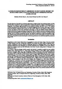
Distribution of Information scores (rotational movements)
Distribution of Information scores (total landslides) 80
70
70
60
60 40
(%)
(%)
terrain units with rotational movements
50 terrain units with landslides
50
terrain units without landslides
30 20
40
terrain units without rotational movements
30 20 10
10
0
0 < -1,0
-1,0 - 0,0 0,0 - 1,0 Information scores
< -1,0
> 1,0
0,0 - 1,0
> 1,0
Information scores
Distribution of Information scores (shallow translational slides)
Distribution of Information scores (translational movements) 60
60
50
50 terrain units with translational movements
30
terrain units without translational movements
20 10
terrain units with shallow translational slides
40 (%)
40
(%)
-1,0 - 0,0
30 terrain units without shallow translational slides
20 10
0
0 < 0,0
0,0 - 1,0 1,0 - 2,0 Information scores
> 2,0
< -1,0
-1,0 - 0,0 0,0 - 1,0 Information scores
of materials through increased pore water pressures. The angle of bedding is lower than the angle of slope in 87% of translational movements. Hence, this geometrical condition is also a critical preparatory condition for activity of this type of landslide. Slopes with gradients higher than 25◦ have the highest information value for shallow translational slides (I i = 0.84). In most cases, these landslides occur on steep slopes and are activated by a decrease in the apparent cohesion of colluvium (thin, and often lying upon an impermeable bedrock), resulting from water infiltration into the soil. Topographical concavities also conditioned the development of shallow translational slides, reflecting the significance of the hydrological regime in slope instability. Soil saturation is achieved most easily in these areas, due to the convergence of surface and subsurface flow.
> 1,0
Fig. 7. Frequency distribution of information value scores of the study area terrain units.
The relevant role of slope gradient on slope instability is confirmed by positive values of information scores for slope classes “15-25◦ ” and “> 25◦ ”, in the four landslide data sets. Also, the variable “slope deposits with thickness > 0.5 m” have a positive relationship with all considered types of slope movements. The higher scores registered for rotational and translational movements seem to result from a spatial autocorrelation between colluvium thicker than 0.5 m and both slope angle < 25◦ , and lithological units 1 and 3, where rotational and deep translational slides concentrate. The information values of “presence of artificial cut (roads)” and “presence of fluvial channel” are systematically high for the four landslide data sets, pointing out the importance of both anthropogenic influence and bank erosion on slope instability in the study area. Figures 3, 4, 5 and 6 show the mapping evaluation of sus-
J. L. Zˆezere: Landslide susceptibility assessment considering landslide typology
81
success rate (%)
100 80 60 40 20 0 0
10
20
30
40 50 60 70 % terrain units
total landslides translational movements
80
90
100
rotational movements shallow transl. slides
ceptibility for the total set of landslides, rotational movements, translational movements and shallow translational slides, according to the information value of variables presented in Table 4. The definition of susceptibility classes takes into account the statistical dispersion of information scores. The obtained prediction models show a different spatial distribution of the highest susceptibility areas, confirming the distinct influence of the instability conditioning factors, depending on the type of slope movements. Figure 4 shows that the highest susceptibility areas for rotational movements overlap quite well with lithological unit 1, pointing out the importance of “Abadia beds” as the main conditioning factor for this type of landslide. Figure 5 evidences cataclinal slopes as the most susceptible concerning translational movements, while slopes with gradients higher than 25◦ are the most susceptible terrain units to shallow translational slides occurrence (Fig. 6). The evaluation performed with the total landslides data set (Fig. 3) evidences a combination between the above mentioned three main landslide conditioning factors. Hence, cataclinal slopes on lithological unit 1, with gradients higher than 15◦ , are classified as the most susceptible zones, that are very prone to the occurrence of all types of slope movements. Nevertheless, it is apparent that more landslides fall out from the highest susceptible areas in this assessment, when compared with those performed with individual types of slope movements. Figure 7 shows the frequency distribution of information scores for both terrain units with landslides and terrain units without landslides. Validation of the method is confirmed by the major classification of unstable terrain units in the first and second high susceptibility classes: total landslides, classes 1 + 2 (64% of total terrain units) include 93% of unstable terrain units; rotational movements, classes 1 + 2 (38% of total terrain units) include 83% of unstable terrain units; translational movements, classes 1 + 2 (35% of total terrain units) include 91% of unstable terrain units; shallow translational slides, classes 1 + 2 (43% of total terrain units) include
Fig. 8. Success rates for total landslides, rotational movements, translational movements and shallow translational slides, using Information Value Method.
73% of unstable terrain units. The obtained success rates are higher for individual landslide types than for the total set of slope movements, namely in what concerns the highest susceptibility scores (Fig. 8). 6
Conclusion
Landslide susceptibility evaluation involves a high level of uncertainty due to data limitations and model shortcomings. Additionally, the accuracy of susceptibility assessment is lower when different types of slope movements are considered as a whole, because those landslides may have different spatial incidence, and distinct threshold conditions concerning preparatory factors. This difficulty may be resolved by defining types of landslides prior to the susceptibility assessment. This procedure was applied in the landslide susceptibility assessment in the study area, using the Information Value Method. The adopted method was applied both to the total set of landslides and to three individual types of slope movements. Success rates were higher in the latter case, showing the importance of discriminate different types of slope movements for a correct modelling of landslide susceptibility. Different types of landslides are not equally conditioned by the instability factors. Information value scores show that lithological unit 1 is the main preparatory condition for rotational movements, while translational movements are mostly conditioned by concordance between the slope and dip of strata. Finally, shallow translational slides have the strongest spatial correlation with slopes with gradients higher than 25◦ . Landslide susceptibility evaluation and prediction deals with the spatial component of hazard, and has as a main goal to answer to the following question: Where will future landslides occur? Research on the spatial probability of landslide occurrence is critically important to the public administrations’ responsible for civil protection, urban planning and environmental management. In any event, different types of
82
J. L. Zˆezere: Landslide susceptibility assessment considering landslide typology
landslides neither have the same magnitude nor equal damaging potential. In Calhandriz area, the deeper and larger slope movements (rotational and translational) may produce serious damage to properties and structures, while shallow translational slides are only responsible for minor road disruptions. Furthermore, the technical strategies to mitigate landsliding also depend on landslide typology. These are additional reasons to discriminate between different types of slope movements when assessing landslide susceptibility and hazard. The landslide susceptibility assessment considering landslide typology needs to be transferred to decision makers who should implement landslide loss-reduction strategies, in order to reduce the likelihood of occurrence of damaging landslides and minimise their social and economic effects. Although vulnerable elements (including population, properties and economic activities) fall into hazardous zones in the Calhandriz area, minor attention has been given to this problem by local authorities. Such behaviour may be explained by the lack of prevention tools and rules concerning landslide hazard and risk in Portugal. Acknowledgements. The author is grateful to A. Carrara and to an anonymous reviewer, whose pertinent comments helped to improve the quality of this paper.
References Ast´e, J.-P.: Landslide Hazard Analysis – Landslide Risk Mapping. In Almeida-Teixeira, M. E., Fantechi, R., Oliveira, R., and Gomes Coelho, A. (Eds.), Prevention and Control of Landslides and Other Mass Movements, Commis. European Communities, Bruxels, 165–170, 1991. Carrara, A., Cardinali, M., and Guzzetti, F.: Uncertainty in assessing landslide hazard and risk, ITC Journal, 1992–2, 172–183, 1992. Carrara, A., Guzzetti, F., Cardinali, M., and Reichenbach, P.: Current limitations in modeling landslide hazard. In Buccianti, A., Nardi, G., and Potenza, R. (Eds.), Proceedings of IAMG’98, 195–203, 1998. Crozier, M. J.: Landslide hazard assessment, theme report. In Bell (Ed.), Landslides, Proceedings of the 6th International Symposium on Landslides, Balkema, Rotterdam, 1843–1848, 1995. Ferreira, A. B., Zˆezere, J. L., and Rodrigues, M. L.: The Calhandriz landslide (Metropolitan area of Lisbon). In Chacon, J., Irigaray, C., and Fern´andez, T. (Eds.), Landslides, Balkema, Rotterdam,
31–38, 1996. Hansen, A.: Landslide hazard analysis. In Brunsden, D. and Prior, D. B. (Eds.), Slope Instability, John Wiley and Sons, Chichester, 523–602, 1984. Hutchinson, J. N.: Landslide hazard assessment, keynote paper. In Bell (Ed.), Landslides, Proceedings of the 6th International Symposium on Landslides, Balkema, Rotterdam, 1805–1841, 1995. Irigaray, C., Chac´on, J., and Fern´andez, T.: Methodology for the analysis of landslide determinant factors by means of a GIS: Application to the Colmenar area (Malaga, Spain). In Chac´on, J., Irigaray, C., and Fern´andez, T. (Eds.), Landslides, Balkema, Rotterdam, 163–172, 1996. Leroi, E.: Landslide hazard – risk maps at different scales: objectives, tools and developments. In Senneset (Ed.) Landslides, Proceedings of the 7th International Symposium on Landslides, Balkema, Rotterdam, 35–51, 1996. Soeters, R. and Van Westen, C. J.: Slope Instability Recognition, Analysis and Zonation. In Turner, A. K. and Schuster, R. L. (Eds.), Landslides. Investigation and Mitigation, Transportation Research Board, Special Report 247, National Academy Press, Washington D.C., 129–177, 1996. Varnes, D. J.: Landslide hazard zonation: a review of principles and practice. UNESCO, Paris, 1984. Yan, T. Z.: Recent advances of quantitative prognoses of landslide in China. In Bonnard, C. (Ed.), Landslides, Proceedings of the Fifth International Symposium on Landslides, Lausanne, 1988, 2, Balkema, Rotterdam, 1263–1268, 1988. Yin, K. L. and Yan, T. Z.: Statistical prediction models for slope instability of metamorphosed rocks. In Bonnard, C. (Ed.), Landslides, Proceedings of the Fifth International Symposium on Landslides, 2, Balkema, Rotterdam, 1269–1272, 1988. Wu, Y., Yin, K., and Liu, Y.: Information analysis system for landslide hazard zonation. In Bromhead, E., Dixon, N., and Ibsen, M.-L. (Eds.), Landslides in Research, Theory and Practice, 3, Thomas Telford, London, 1593–1598, 2000. Zˆezere, J. L.: Rainfall triggering of landslides in the Area North of Lisbon. In Bromhead, E., Dixon, N., and Ibsen, M.-L. (Eds.), Landslides in Research, Theory and Practice, 3, Thomas Telford, London, 1629–1634, 2000. Zˆezere, J. L., Ferreira, A. B., and Rodrigues, M. L.: Landslides in the North of Lisbon Region (Portugal): Conditioning and Triggering factors, Physics and Chemistry of the Earth (Part A), 24, 10, 925–934, 1999a. Zˆezere, J. L., Ferreira, A. B., and Rodrigues, M. L.: The role of conditioning and triggering factors in the occurrence of landslides: a case study in the area north of Lisbon (Portugal), Geomorphology, 30, 1–2, Elsevier, 133–146, 1999b.