establishes a baseline data set for under- standing .... The new set of findings includes the dis- covery of 54 ... surrounding galaxies to find life and the extent of ...
Eos, Vol. 92, No. 7, 15 February 2011 Workshops about calderas are organized on a regular basis (on average, every 2 years) and have been held at Tenerife, Canary Islands (2005); the Trans-Mexican Volcanic Belt, in Querétaro, Mexico (2008); and Réunion Island, in the Indian Ocean (2010). These workshops have allowed CCC members and other researchers to interact and exchange their multidisciplinary expertise on calderas through dedicated sessions and field excursions on different types of calderas. As part of the last workshop, held in Réunion, CCC started a new initiative, the International Course on Collapse Calderas. This course is open to undergraduate students, Ph.D. candidates, and postdocs. The next course and workshop are planned for late September 2012 in the Vulsini caldera district (Bolsena and Latera calderas), in Italy. Scientific results have been inspired by or benefited from the multidisciplinary approach of these workshops, giving the scientific community the opportunity to discuss and focus on both specific and general aspects of calderas. Significant results among these are the publication of a book entitled Caldera Volcanism: Analysis, Modelling and Response [Gottsmann and Martí, 2008] and review studies on caldera formation, structure, and classification [e.g., Acocella, 2007; Martí et al., 2009]. CCC has strongly encouraged the use of new methodologies, mainly using mathematical and analogue models, as well as
fundamental field volcanology to understand caldera collapse. These models have provided a robust scientific foundation for further understanding of caldera structure, development, and eruptive behavior.
Future Challenges Future challenges for CCC include ensuring open access of scientific results as they are acquired by the caldera research community and facilitating discussion on key facets of calderas that remain poorly understood. These include the role of regional tectonics and preexisting discontinuities in eruptive behavior, how resurgence is triggered, and the nature of eruptive patterns as a function of the stress state and processes within the chamber. Additionally, CCC aims to present acquired knowledge for easy use by those conducting hazard assessments and to provide background information on the economic benefits of caldera systems. Paramount issues that CCC plans to tackle include proposing a systematic classification of calderas; understanding the root causes and triggers of caldera unrest; uncovering how periods of unrest lead to eruptions; quantifying the climate effects of caldera-forming eruptions; and revealing the interconnections among caldera structures, geothermal energy, and hydrothermal ore deposits.
New High-Resolution Images of Summer Arctic Sea Ice PAGES 53–54 In 1995 a group of government and academic scientists were appointed by the vice president of the United States to review and advise on acquisitions of imagery obtained by classified intelligence satellites (National Technical Means) and to recommend the declassification of certain data sets for the benefit of science. The group is called MEDEA and was first described by Richelson [1998]. MEDEA disbanded in 2000 but reassembled in 2008. On 15 June 2009, under the auspices of MEDEA, the U.S. Geological Survey (USGS) released to the public as Literal Image Derived Products (LIDPs) numerous images with 1-meter resolution acquired since 1999 at six locations in the Arctic Basin (Beaufort Sea, Canadian Arctic, Fram Strait, East Siberian Sea, Chukchi Sea, and Point Barrow). These locations are named “fiducial sites” to suggest that the collected imagery establishes a baseline data set for understanding recent and future changes. Data in the Global Fiducials Library (GFL) can be
accessed via http://gfl.usgs.gov/. This data repository is updated by USGS as additional data become available. As described in the National Research Council [2009] report “Scientific value of Arctic Sea ice imagery derived products,”
The accomplishment of these goals will not only help scientists to significantly increase their knowledge on collapse calderas but will also help them to better characterize the natural resources linked to calderas and to assess hazards and their mitigation during times of caldera unrest.
References Acocella, V. (2007), Understanding caldera structure and development: An overview of analogue models compared to natural calderas, Earth Sci. Rev., 85(3-4), 125–160, doi:10.1016/j.earscirev .2007.08.0 04. Gottsmann, J., and J. Martí (Eds.) (2008), Caldera Volcanism: Analysis, Modelling and Response, Dev. Volcanol. Ser., vol. 10, 492 pp., Elsevier, New York. Martí, J., A. Geyer, and A. Folch (2009), A genetic classification of collapse calderas based on field studies, and analogue and theoretical modeling, in Studies in Volcanology: The Legacy of George Walker, edited by T. Thordarson et al., pp. 249–266, IAVCEI Spec. Publ., 2, Geol. Soc. of London, London. —Gerardo Aguirre-Diaz, Centro de Geociencias, Universidad Nacional Autónoma de México, Querétaro, Mexico; Adelina Geyer, Centre Internacional de Mètodes Numèrics en Enginyeria, Barcelona, Spain; Joan Martí, Institute of Earth Sciences, Consejo Superior de Investigaciones Cientifícas, Barcelona, Spain; and Valerio Acocella, Dipartimento di Scienze Geologiche, Università degli Studi Roma Tre, Rome, Italy; E-mail: acocella@uniroma3.it
which was published at the same time as the data release in 2009, these LIDPs are valuable for understanding changes in the Arctic Ocean sea ice cover. Individual LIDPs are 1-meter-r esolution, geocoded panchromatic images that cover an area of approximately 15 × 15 kilometers of Arctic sea ice. Since Arctic stratus clouds frequently obstruct imaging of the surface during summer, repeated acquisitions are typically required to obtain a single cloudfree scene of the surface.
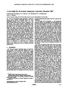
Fig. 1. High-resolution (1-meter) Image Derived Products (IDP) imagery captures the development of melt ponds on drifting sea ice: (left) prior to the onset of melt on 3 July 2009, (middle) melt pond coverage on 30 July 2009, and (right) partial freeze-up on 19 August 2009. Differences in the coverage and geometry of melt ponds over seasonal and multiyear ice can clearly be seen. Acquisitions of the imagery of these drifting ice parcels are guided by the locations of drifting buoys.The ensemble drifted a net distance of approximately 220 kilometers from 86.1°N, 3.3°E to 84.1°N, 2.4°W over the period of about 46 days. Each image covers an area of 400 × 400 meters.
Eos, Vol. 92, No. 7, 15 February 2011 In early 2009, MEDEA requested additional collections to track the same ensemble of ice floes over the course of the summer. Repeated imaging of the ice cover was guided by the positions of data buoys in the vicinity of these floe ensembles. Buoy positions are provided by the International Arctic Buoy Programme (IABP; http://iabp .apl.washington.edu/). LIDPs from four “tracked” or drifting sites from summer 2009 have been released and can be found on the GFL Web site mentioned above. Two examples illustrate the numerous potential uses of these data sets. Figure 1 shows the seasonal development and coverage of melt ponds in the high Arctic, while Figure 2 shows the retrieval of ridge height using the direction and elevation of solar illumination. Two other applications suggest themselves: (1) Uncertainties in ice concentrations derived from satellite passive microwave radiometers in summer are not well understood. Comparisons with the open-water fraction from the LIDPs would make it possible to better establish the uncertainties in the retrievals. (2) Lateral melting of the ice floes plays an important role in the surface energy balance in summer. Results from limited field measurements indicate that lateral ablation can reach several meters. The analysis of sequential high-resolution images from LIDPs would allow the analysis of the evolution of ice concentration, floe size distribution, and lateral melting.
Richelson, J. T. (1998), Scientists in black, Sci. Am.,
Fig. 2. (a) Sea ice ridge height relative to the local snow surface estimated using shadow length and direction and elevation of solar illumination (white arrow). Image location is 84.9°N, 118.7W. The small image at right is an enlarged version of the ridge within the box indicated by the dashed arrow. (b) Example contrasts the ridge height distributions in first-year and multiyear sea ice from four different fiducial sites during early summer. The distributions show higher occurrences of taller ridges in multiyear sea ice than in first-year sea ice.
It is anticipated that under the auspices of MEDEA, USGS will continue to manage the collection of such images in the future and prepare the LIDPs for scientific use.
References
Kepler Mission Discovers Trove of Extrasolar Planet Candidates NASA’s Kepler discovery mission is collecting more than just pennies from heaven. Results from the first 4 months of science operations of the Kepler space telescope, announced on 2 February, include the discovery of 1235 candidate planets orbiting 997 stars in a small portion of the Milky Way galaxy examined by the telescope. Follow-up observations likely could confirm about 80% of the candidates as actual planets rather than false positives, according to researchers. This new trove of possible exoplanets could greatly expand the number of known planets outside of our solar system. The new set of findings includes the discovery of 54 candidate planets orbiting in what is called the habitable zone around their stars, a zone where conditions might be right to allow for liquid water to be present on a planet’s surface. In addition, scientists found the first ever Earth-sized planet candidates, 68 of them, that are up to 1.25
—Ronald Kwok, Jet Propulsion Laboratory, California Institute of Technology, Pasadena; E-mail: ron.kwok@jpl.nasa.gov; and Norbert Untersteiner, University of Washington, Seattle
National Research Council (2009), Scientific value of Arctic sea ice imagery derived products, report, 48 pp., Natl. Acad. Press, Washington, D. C.
NEWS PAGE 54
278, 48–55.
times the size of Earth; 170 stars that show the presence of multiple planet candidate systems; and a planetary system that has been confirmed to have six transiting planets tightly orbiting a Sun-like star, known as Kepler-11. The inventory of these discoveries, from Kepler’s observations made between 12 May and 17 September 2009 of 155,453 stars in a field of view about 1/400th of the sky, includes 288 extrasolar planet candidates that are super-Earth-sized, 662 Neptunesized candidates, 165 Jupiter-sized, and 19 that are larger than Jupiter. “Kepler looks at 1/400th of the sky. If we had 400 of these fields of view, we would see 400 times the number of candidates: We would see 400,000 candidates,” said William Borucki, Kepler science principal investigator with NASA’s Ames Research Center, Moffett Field, Calif., at a 2 February news conference to announce Kepler results. “The stars that surround us have a huge number of planets and candidates
for us to look at. And if we find Earth-sized planets are common in the habitable zone of life, it is very likely that means life is common around these stars. Kepler is the first step of mankind’s exploration of the surrounding galaxies to find life and the extent of life in our galaxy.” Jack Lissauer, Kepler coinvestigator and planetary scientist at Ames, said that Kepler-11, which is about 2000 light years away from Earth, has “the most compact system of planets ever discovered by any technique anywhere.” The five inner planets orbiting Kepler-11 are all closer to that star than any planet in our solar system is to our own Sun; the orbit of the sixth planet is smaller than the orbit of Venus; and all six of the planets are low density and larger than Earth. Lissauer said, “We see this target turning like a clock, but like a very special clock, one with six hands moving at six different rates, and we interpret this as six planets orbiting very near the same plane.” Noting that Kepler-9 was the only star known to have more than one transiting planet prior to the new findings, Lissauer said the Kepler-11 planetary system enables scientists to determine the masses of the inner five bodies by the amount they tug on one another’s orbits and “forces us to go back and look at formation models of planets.” To adequately describe the Kepler-11 system, he called it “supercalifragilisticexpialidocious.”