The DLR operates different Scientific Data Pools to guarantee the scientific community ... 2) Data information and management system and 3) RapidEye payload.
RapidEye Science Archive: Remote Sensing Data for the German Scientific Community1 Borg, E., Daedelow, H., Apel, M., Missling, K.-D.
Abstract The RapidEye Science Archives RESA-project funded by the Bundesministerium für Wirtschaft und Technologie (BMWi - Federal Ministry of Economics and Technology) and provided by the RapidEye and the German Aerospace Center (DLR), Earth Observation Center (EOC) is an essential contribution to a broad scientific environmental applications of RapidEye data and to develop applications, value added products as well as services based on these RapidEye-data. The national project RESA accompanies the GMES initiative (Global monitoring for environment and Security) of the European Union (EU) and the European space agency (ESA) with that. The uncomplicated and generous appropriation of RapidEye-data by the RESA project innovative services based on satellite and airborne remote sensing can be implemented and combined with terrestrial, maritime and additional data sources. This concerns the cognitive process in operational remote sensing data processing as well as the data providers as e.g. RapidEye.
1.
Introduction
Within the last few years the situation of satellite and airborne supported remote sensing has changed fundamentally. The reasons can be explained among others by the following aspects: •
1
technical and technological developments and factors, such as the increase of the number of earth observation missions (e.g. multiple satellite missions on different or on one orbit), new advanced sensor technologies (e.g. SAR- and hyperspectral sensors of high spatial
This is an updated and translated into English version of the introduction contribution of 4th conference volume “Rapid Eye Science Archive (RESA) – Vom Algorithmus zum Produkt”.
•
resolution), new storage media and storage technologies, and new improved data processing (e.g. automated interpretation algorithms and processing chains), market-oriented aspects (e.g. private remote sensing missions, such as QuickBird or RapidEye).
In addition to this the development was politically forced by European Union (EU) and European Space Agency (ESA) having established the program "Global monitoring for environment and Security" (COPERNICUS; erstwhile called GMES), which serves the development of an operative European Earth observation satellite fleet to combine earth observation monitoring with airborne remote sensing supported by terrestrial, maritime in-situ-measuring networks and additional data sources in operative process chains as well as services. Besides the continuous provisioning of user friendly and reliable earth observation services e.g. to climate protection, for ecological survey, humanitarian assistance or for the reply to security-relevant questions the GMES initiative is aimed at the establishment of a European market for innovative remote sensing based services.
2.
The RapidEye-System
The RapidEye system consisting of 5 satellites was launched on August 29th, 2008. The system has switched in the operative phase and provides remote sensing data since February 1st, 2009. RapidEye is now a leading provider of quality high-resolution satellite imagery. With a constellation of five Earth Observation satellites, RapidEye images up to five million square kilometers of earth every day, and adds over one billion square kilometers of imagery to its archive every year. Every square kilometer imaged by RapidEye can be browsed with its online discovery tool, EyeFind (eyefind.rapideye.com). With an unprecedented combination of wide area repetitive coverage and five meter pixel size multispectral imagery, RapidEye is a natural choice for many industries and
governments. RapidEye is headquartered in Berlin, Germany and has additional offices in the US and Canada. The benefits are: • • • • • • •
Regions, states and entire countries can be imaged in a short amount of time Cost effective high-resolution data Effective for land cover / land use classification applications, change detection, background imagery, mapping, biophysical monitoring, etc. Seventy percent (70%) of RapidEye‘s imagery is taken at 10° off nadir or less Over sixty percent (60%) of RapidEye‘s archive has 10% cloud cover or less RapidEye‘s Red Edge band assists in advanced vegetation discrimination and identification of vegetation health status EyeFind is RapidEye‘s online discovery tool, allowing easy access of the entire RapidEye archive: eyefind.rapideye.com
Tab.1: Mission and Product Characteristics (http://www.rapideye.com/about/resources.htm)
Depending on the task at hand, two different levels of RapidEye imagery are commercially available:
Tab.2: RapidEye Standard Imagery Processing Level (http://www.rapideye.com/about/resources.htm) Additionally, multiple RapidEye satellite images are used to cover a country or region with very minimal cloud cover to generate RapidEye Mosaics™. These images are geometrically aligned and orthorectifed to insure that they are precisely located. They are uniformly colour-balanced to ensure a highquality natural colour image that is produced using the native Red, Green and Blue bands of the RapidEye satellites. The RapidEye Mosaics™ are conveniently formatted into a ready-to-use product, in standard file formats that are Open & GoGIS ready, requiring no further processing.
Tab.3: Off-The-Shelf Mosaic Product Characteristics (http://www.rapideye.com/about/resources.htm)
Features are: • • • •
True natural colour in Red, Green, Blue (RGB) derived from RapidEye‘s 5 meter resolution satellite imagery, Cloud-free imagery whenever possible (always less than 3%), The most current high-resolution mosaics available, with narrow acquisition windows, Off-the-shelf or custom-made options.
3.
The RESA-Project
3.1
Scientific-Data-Pools for Remote Sensing Data
The DLR operates different Scientific Data Pools to guarantee the scientific community a simplified and cost-effective or cost-free access to remote sensing data. Examples of it are the LANDSAT 7/ETM+Scientific Data Pool, the TerraSAR-X Scientific Data Pool (http://sss.terrasar-x.dlr.de/), and the RapidEye Science archive (http://resaweb.dlr.de). Thus, the recognition is supported that a broader scientific application of remote sensing data benefits not only the community as well as the data provider. Benefits are (Lievesley, 2009): • • • • • • • • •
Gain in cognition, Promoting of a broader application of remote sensing data, Contributions to informed political decisions, Support of multiple application and use of data, Facilitate of comparative research, Increase of the expert user community, Feedback on data and data quality, Improvement of teaching and ensuring the relevance of official statistics, and Feedback to the commercial sector (market enlargement, Saarikivi, 2009).
3.2
Objectives of RESA-Project
Ecological policy needs reliable information about state and development of the environment to be able to recognize undesirable developments on time and react to it after priorities graded adequately (von Gadow, 1995). Therefore, an appropriation of current and full-coverage geo-information becomes required urgently to support decision-making processes in politics, public, and economy. Against this background, both the European Union (EU) and the European Space Agency (ESA) expect an increasingly national effort for the realization of these objectives. The national efforts correspondingly are various to comply cost-effectively and innovatively the duties of information to the EU. With respect to this, the RESA project accomplishes essential services in the field of strengthening of the national interests of geo-information industry. For German science these are the following aspects: 1. 2. 3. 4. 5. 6.
preparation and ready provision of the technological infrastructure for the long-term data storage, long-term archiving, distribution, and provision of the RapidEye data, coordination and optimization of the use of the limited data contingent, assessment of project propositions as well as the coordination of data requirements, appropriation of user information by internet portal and annual workshops, monitoring of limitations agreed by contract to exclusively scientific use and compliance to the data use guidelines of the RESA project.
The operative and cost-effective provision of corresponding remote sensing data is the professed business model of the RapidEye. Therefore German Aerospace Center (DLR) and RapidEye have agreed to provide cost free to the German science a data contingent of 29.4 million square kilometer for a time period of seven years. The distribution of the data contingent is operated by the RESA.
During the initial phase of the RESA project, strategic interface projects of national importance to the GMES initiative were in the focus of interest (e.g. DeCOVER-land applications, DeSECURE civil protection, DeMARINE Ocean applications). During the project, the focus of the project have shifted towards a broad availability of data for users from diverse geo-science topics, to drive the development of RapidEye data processing from the first experience over the first products to first services. In order to support this process, increasingly educational aspects of the users of RapidEye data were considered by the RESA team. In cooperation with the RapidEye scientific works such as e.g. bachelor's degree, diploma, master's theses, and theses were uncomplicatedly supplied with data. For this, the initially met restrictions of the contract with the RapidEye were examined. In addition the initially encountered restrictions of contract with the RapidEye concerning the ordered data contingent were reviewed to change the limitations for the benefit of the users, if possible.
3.2
Order System and Order Method of the RESA-Project
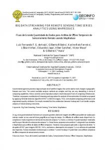
The RESA project is supported by the components 1) Science service system, 2) Data information and management system and 3) RapidEye payload ground segment. The science service system offers scientists the opportunity to submit project proposals for the evaluation by independent auditors (see Chapter 3.4). In the case of a positive evaluation, the service request of the project will transferred by the RESA team to the company RapidEye as an order. Here archive orders are immediately processed and shipped. Tasking orders (orders for data recording in the future) be merged into the company RapidEye mission planning system. The distribution is controlled by a data server of the RapidEye. From here, the data are cyclically transmitted and processed through the RESA-ingestion processing system. Then the data is archived in the product
library and uploaded into DLR’s user interface “Earth Observation on the WEB” (EOWEB). Here, the user has the possibility to search for data of the RESA project and to order these free of charge. RapidEye Processing Ground Segment
Product Level 1A, 2A, 3A
Antennen
Satelliten
Data Information and Management System RESA Ingestion Processing System
Product Library
PSM
Inventory
Quality Control
RESA Science Service System
Order
Order Control
EOWEB User Registration Submission of Proposals Evaluation of Proposals
Archive
Product Delivery
User Registration Proposal Delivery Status
Mission Planing Status
Order
Legend Data Flow
RapidEye Processing Ground Segment (RE-PGS)
Request
RESA Science Service System (RESA – SSS)
RapidEye Processing Ground Segment Mission Planing
Order Interface for RESA
Data Information and Management System (DIMS)
Fig. 1: Schematic pictogram of the structure the RESA project 3.3
Data Output and Project Submission
Scientists have the ability to prepare proposals on the RESA-portal (resaweb.dlr.de). If the application is fully registered and has the status "submitted", by science service team an assignment is made to an expert. The status is set to "handed over". These proposals are then examined by experts and evaluated. The expertise passes through different status (see Fig. 2). If the project is being viewed positively by the expert ("evaluated"), a final control is made by the science-service team and the status of the paper is set to "approved". In this case, the data order is verified and transmitted to the company RapidEye.
However, if the expert formulates requirements and / or suggestions to improve the project proposal, the status of the project proposal is set to "dismissed with modification". Then the proposer has the possibility to improve and consider the suggestions of the expert. Subsequently, a renewed valuation takes place.
RESA -Proposal Request-Flow yes Accepted Proposal
released (EOWEB)
Tasking?