IEEE TRANSACTIONS ON SYSTEMS, MAN, AND CYBERNETICS, NO. Y, MONTH 1999
100
Real-Time Map Building and Navigation for Autonomous Robots in Unknown Environments Giuseppe Oriolo, Giovanni Ulivi, and Marilena Vendittelli Abstract—An algorithmic solution method is presented for the problem of autonomous robot motion in completely unknown environments. Our approach is based on the alternate execution of two fundamental processes: map building and navigation. In the former, range measures are collected through the robot exteroceptive sensors and processed in order to build a local representation of the surrounding area. This representation is then integrated in the global map so far reconstructed by filtering out insufficient or conflicting information. In the navigation phase, an A⋆ -based planner generates a local path from the current robot position to the goal. Such path is safe inside the explored area and provides a direction for further exploration. The robot follows the path up to the boundary of the explored area, terminating its motion if unexpected obstacles are encountered. The most peculiar aspects of our method are the use of fuzzy logic for efficiently building and modifying the environment map, and the iterative application of A⋆ , a complete planning algorithm which takes full advantage of local information. Experimental results for a NOMAD 200 mobile robot show the real-time performance of the proposed method, both in static and moderately dynamic environments.
I. Introduction
I
N recent years, an increasing amount of robotics research has focused on the problem of planning and executing motion tasks autonomously, i.e., without human guidance; e.g., see [1], [2], [3]. Such a faculty is essential for robotic systems operating in hostile environments (space, sea, contaminated habitats) as well as in the emerging field of service robotics, that include waste management, cleaning, luggage transfer, disabled people assistance, and others. To reach a reasonable degree of autonomy, two basic requirements are sensing and reasoning. The first is provided by an on-board sensory system that gathers information about the robot itself and the surrounding scene. The second is accomplished by devising algorithms that exploit this information in order to generate appropriate commands for the robot. To make the use of robots appealing in real-life applications, it is necessary to reach a trade-off between costs and benefits. Often, this prevents the use of expensive sensors (e.g., video cameras) in favor of cheaper sensing devices, and calls for efficient algorithms that can guarantee real-time performance in the presence of insufficient or conflicting data. Manuscript received . . . . . . . . . G. Oriolo and M. Vendittelli are with the Dipartimento di Informatica e Sistemistica, Universit` a degli Studi di Roma “La Sapienza”, Via Eudossiana 18, 00184 Rome, Italy. E-mails:
[email protected],
[email protected]. G. Ulivi is with the Dipartimento di Informatica e Automatica, Terza Universit` a degli Studi di Roma, Via della Vasca Navale 84, 00146 Rome, Italy. E-mail:
[email protected] . This work was partially supported by ENEA funds (Antarctica Project) and by ESPRIT BR Project 6546 (PROMotion).
In this paper, we address the problem of autonomous navigation in a completely unknown environment for a robot equipped with ultrasonic range finders. If the robot must perform several motion tasks in the same static workspace, it may be convenient to perform a preliminary, exploratory phase in order to reconstruct accurately the environment (e.g., see [2, Ch. 5]). The high cost of such operation will be compensated by the ease of planning on a globally known map. Moreover, a global knowledge of the environment allows to plan paths that optimize a given performance criterion. In many cases, an exploratory phase is out of question, either because the characteristics of the environment are subject to change over time, or simply because the nature of the robot task would make it inefficient. The robot must then be able to accomplish the motion in the absence of initial knowledge. Various approaches to this problem have been proposed so far. Despite their differences, most techniques can be classified within two major streams, i.e, reactive and deliberative navigation. In reactive methods, there is a stimulus-response relationship between sensors and actuators, with very limited or no world modeling at all; e.g., see [4], [5], [6], [7], [8], [9]. In deliberative techniques, a world model is used to formulate plans to which the robot is more or less committed; one example of this kind is given in [10]. While reactive navigation proves to be flexible by virtue of its modular design approach, it may fail when confronted with difficult tasks. On the other hand, deliberative navigation suffers from high computational requirements and performance degradation in dynamic environments. Based on the idea that ‘dynamically acquired world models can be used to circumvent certain pitfalls that representationless methods are subject to’ [11], a number of mixed solutions have been proposed, aimed at an efficient integration of world modeling and planning into reactive architectures; e.g., see [12], [13]. Our solution is somewhat in the line of mixed methods. In fact, it prescribes the incremental building of a dynamic world representation and the formulation of local plans in accordance. Its originality stands mainly in two aspects. The first is the use of a particular world model that is easily aggregated and modified during the motion through a memoryless algorithm that requires no post-processing. The second is the iterative application of A⋆ , which is a global planning method but takes full advantage of the available local information. In selecting an appropriate world model, one must face the fact that ultrasonic sensors, although low-cost and easy to use, may behave poorly in certain conditions [14].
IEEE TRANSACTIONS ON SYSTEMS, MAN, AND CYBERNETICS, NO. Y, MONTH 1999
Therefore, rather than trying to reconstruct a deterministic model of the environment, we have chosen to adopt an intrinsically uncertain map, defined as a fuzzy set: a real number is associated to each point, quantifying the possibility that it belongs to an obstacle. The resulting representation is similar to an occupancy grid, commonly obtained using stochastic techniques [15], [16], [17], [18]. We have found that fuzzy logic provides a more robust and efficient tool for managing the uncertainty introduced by the ultrasonic sensing process. In fact, the underlying theory is developed from less constraining axioms than probability theory, so that a wider choice of operators is available for modeling uncertainty and aggregating information coming from multiple sources [19]. As the environment map is incrementally built, the local planner is repeatedly invoked in order to generate a robot path from the current position to the desired goal. Such path must be safe inside the area so far explored, and at the same time should provide directions for further exploration aimed at reaching the goal. This is realized by defining cost functions that characterize the risk of collision along a path, and by choosing a proper instance of the A⋆ class of graph search algorithms in order to obtain a minimum-cost path. Our method represents an attempt to make use of strictly algorithmic techniques in the presence of unknown and/or dynamic environments, with as little as possible sophistication in the control structure of the robot. In fact, while it is possible to devise general control architectures that behave robustly in various situations (e.g., see [4]), in this way one might be forced to give up interesting formal properties such as completeness (i.e., the capability of finding a solution whenever one exists), that can instead be guaranteed by algorithmic approaches. Further advantages of these are the possibility of analyzing complexity as well as the efficiency of the obtained paths. The paper is organized as follows. In the next section, we present our solution approach and outline the overall structure of the navigation method. In Sect. III, the various phases of the fuzzy map building algorithm from ultrasonic measures are reviewed. In Sect. IV, cost functions are introduced for characterizing safe paths on fuzzy maps and it is shown that the A⋆ algorithm can be applied for finding minimum-cost local paths. Experimental results are presented in Sect. V to show the satisfactory performance of our approach both in static and moderately dynamic environments. A short review of the basic concepts of fuzzy set theory is given in the Appendix. II. The proposed approach Consider a mobile robot equipped with ultrasonic range finders that must travel from its initial position to a final desired position across a completely unknown twodimensional environment. Throughout the paper, we assume that a localization system provides the robot with its absolute position with respect to a fixed inertial frame. Our approach is based on the use of two basic processes, map building and navigation, that are alternately performed during the task execution (see Fig. 1). A short
101
qualitative description of their functions is given below. Map Building The map building process is in charge of gathering through the sensors information about the environment at a given robot position and of processing it in order to update the available map in accordance. The basic steps are: Perception. The robot ultrasonic sensors are activated in a proper sequence and a packet of n range readings are collected. Processing. Ultrasonic measures are processed in order to build a local representation of the surrounding scene in terms of empty and occupied space. Fusion. The local representation is integrated in the global one by filtering out contradictory and insufficient information. In particular, two gray-level bitmaps Mm and Mp are computed. Unexplored areas are regarded as dangerous in Mm (motion map), while they are considered to be safe in Mp (planning map). At the end of the last step, a new navigation process is started. ⋄ Navigation The navigation process generates robot motions on the basis of the information provided by the map building one. It prescribes two phases: Planning. An A⋆ -based planner computes a path from the current robot position to the goal on the planning map Mp . This path will be safe inside the area explored so far, and will aim directly at the goal outside. Motion. The planned path is followed as long as it is safe on the motion map Mm , i.e., up to the boundary of the explored area. This phase is aborted if the proximity sensors detect unexpected obstacles that obstruct the motion. If the goal has not been reached at the end of the motion phase, a new map building process is started. ⋄ Two comments arise with reference to the approach so far outlined. •
Assume that the map building method provides an exact representation of the environment inside the explored area. It is easy to understand that, if the environment is static, the proposed method is complete, i.e., it provides a solution whenever one exists and returns failure otherwise. In fact, if a solution exists, the explored area is increased until it contains the goal. At this point, the completeness of A⋆ guarantees that a path inside this area (that is limited by construction) is found. Conversely, if the problem does not admit a solution, the robot will explore all the connected region that can be reached from the start position. When the map of this area is completed, the planner will return a failure. Although the underlying assumptions will
IEEE TRANSACTIONS ON SYSTEMS, MAN, AND CYBERNETICS, NO. Y, MONTH 1999
not be satisfied in practice, this reasoning provides a nice theoretical support to the whole approach. •
In the above description, the robot is required to stop in order to collect ultrasonic measures during the map building process. For clarity of exposition, we shall keep this separation between the two processes. However, to reduce the time consumed by the perception phase—by far the most expensive—the latter can be performed during motion execution, provided that map building and navigation are implemented as concurrent processes.
In the following, we shall detail the above approach with reference to the NOMAD 200 mobile robot produced by Nomadic Technologies. As shown in Fig. 2, NOMAD has a cylindrical shape with an approximate radius of 0.23 m, and a kinematic model equivalent to a unicycle. The upper turret, which carries 16 Polaroid ultrasonic sensors, may be independently rotated. The robot control software runs under Unix on an IBM RISC 6000 that communicates with NOMAD through a radio link. All the algorithms for map building and navigation have been implemented in the C language. III. The map building process The problem of building a map from ultrasonic measures is made difficult by the large amount of uncertainty introduced by the sensing process. This uncertainty consists in a lack of evidence: due to the inherent limitations of ultrasonic sensors, it is not always possible to decide whether a given point of the area of interest is occupied or not by an obstacle. Rather than deciding (i.e., classifying points of the space as either empty or occupied) in this unfavorable situation, a possible alternative approach is to convey all the available knowledge into an uncertain representation. Fuzzy logic offers a natural framework in which uncertain information can be handled. Studies on the theory of fuzzy sets started in the early 70’s, with the seminal papers of Zadeh (e.g., see [20]). A review of the basic concepts needed for our purposes is presented in the Appendix. Define the empty and the occupied space as two fuzzy sets1 E and O over the universal set U (the environment), that is assumed to be a two-dimensional subset of IR2 discretized in Σ = σ1 × σ2 square cells of side δ. Their membership functions µE (C) and µO (C) quantify the degree of belief that the cell C ∈ U is empty or occupied, respectively. This degree of belief should be computed on the basis of the available measures. In the fuzzy logic context, the two sets E and O are not complementary—the principle of tertium non datur does not hold. Therefore, for a given cell C, µE (C) and µO (C) convey independent information. This situation is particularly convenient in view of the characteristics of the ultrasonic sensing process (see Sect. III-A). In fact, an ultrasonic sensor detects the closest reflecting surface inside its radiation cone, thereby indicating the presence of an empty 1 Hereafter,
we denote fuzzy sets by calligraphic capital letters.
102
space up to a certain distance. On the other hand, no information is provided about the state of the area beyond such distance: the available evidence does not suggest neither emptiness nor occupancy. Only by incorporating measures taken at different viewpoints it will be possible to discriminate between the two possibilities. As mentioned in the previous section, the k-th map building process consists of three phases, i.e., perception, processing and fusion (see Fig. 3). In the perception phase, a packet of ultrasonic measures {rik } (i = 1, . . . , n) are collected from the same robot position and fed to the processing phase, that is in charge of generating two local representations of the empty and the occupied space, i.e., two local fuzzy sets E k and Ok . During the fusion phase, the local information is aggregated to the global representation of the empty and the occupied space, which is contained in two global fuzzy sets E and O. The final step is to elaborate the information contained in E and O so as to update two further fuzzy sets Mp and Mm . Both are gray-level bitmaps conveying information about the risk of collision for each cell of the environment, but they are based on a different definition of risk. In particular, unexplored areas are dangerous in Mm (motion map), while they are safe in Mp (planning map). Below, each phase of the map building process is described in detail. A. Perception Ultrasonic range finders measure the distance from obstacles in the environment by a simple conversion of the time of flight of the ultrasonic waves in air. As already mentioned, the mobile robot NOMAD 200 is equipped with a ring of 16 Polaroid ultrasonic range finders. These are constituted by a single transducer acting both as a transmitter and a receiver; a packet of ultrasonic waves is generated and the resulting echo is detected. The time delay between transmission and reception is assumed to be proportional to the distance of the sensed obstacle. The multi-lobed beam pattern of the transmitter can be obtained from the radiation directivity function of a plane circular piston D(ϑ) = 2
J1 (ωp sin ϑ) , ωp sin ϑ
(1)
where J1 (·) is the first-order Bessel function, ω = 2π/ℓ depends on the wavelength ℓ, p is the piston radius and ϑ is the azimuthal angle measured with respect to the beam central axis. For the Polaroid sensor [21], it is p = 0.01921 m and ℓ = c/ν, where c is the sound speed in air and ν = 49.410 kHz. For practical purposes, it is sufficient to take into account only the principal lobe of the pattern. As a consequence, the waves are considered to be diffused over a radiation cone of 25◦ width. A single range reading r is affected by three basic sources of uncertainty: •
The sensor has a limited radial resolution. The standard Polaroid range finder can detect distances from 0.12 to 6.5 m with 1% accuracy over the entire range.
IEEE TRANSACTIONS ON SYSTEMS, MAN, AND CYBERNETICS, NO. Y, MONTH 1999
•
The angular position of the object that originated the echo inside the radiation cone is not determined. For example, all the three obstacles of Fig. 4 will give the same distance reading.
•
If the incidence angle is larger than a critical value φ, the sensor reading is not significant because the beam may reach the receiver after multiple reflections, or even get lost (see Fig. 4). The angle φ depends on the surface characteristics, ranging from 7–8◦ for smooth glass to almost 90◦ for very rough materials.
During the perception phase, ultrasonic sensors are fired in such a sequence that interference phenomena are minimized, and measures are recorded together with the position of the corresponding sensor. At each robot position, the ultrasonic ring undergoes two consecutive rotations of 7.5◦ ; as a consequence, 16 × 3 = 48 range readings are obtained. Each point of surrounding area falls inside a minimum of 3 radiation cones. This redundancy of measures will be exploited in the processing phase in order to achieve a more accurate estimate of the angular position of the detected obstacle. B. Processing The objective of this phase is to build two local fuzzy sets E k and Ok . E k (Ok ) is obtained by merging the sets Eik (Oik ), for i = 1, . . . , n, each representing the evidence that a cell is empty (occupied) provided by the single range reading rik . The membership functions of Eik and Oik have a simple structure that reflects the previous qualitative description of the sensing uncertainty. A single reading r provides the information that one or more obstacles are located somewhere along the 25◦ arc of circumference of radius r. Hence, while points located in the proximity of this arc are likely to be occupied, there is evidence that points well inside the circular sector of radius r are empty. To model this knowledge, we introduce the two functions 0 ≤ ρ < r − ∆r kE ¡ ¢2 (2) fE (ρ, r) = kE r−ρ r − ∆r ≤ ρ < r ∆r 0 ρ≥r 0 ≤ ρ < r − ∆r 0 h ¡ ¢ i r−ρ 2 r − ∆r ≤ ρ < r + ∆r (3) fO (ρ, r) = kO 1− ∆r 0 ρ ≥ r + ∆r,
that describe, respectively, how the degree of belief of the assertions ‘empty’ and ‘occupied’ vary with ρ for a given range reading r. Here, ρ is the distance from the sensor, kE and kO are two positive constants corresponding to the maximum values attained by the functions, and 2 · ∆r is the width of the area considered ‘proximal’ to the arc of radius r. The value of ∆r should be selected in such a way to ‘augment’ slightly the occupied area, providing a convenient safety margin for the navigation phase. The profile of fE and fO is displayed in Fig. 5. Since the intensity of the waves decreases to zero at the borders of the radiation cone, the degree of belief of each
103
assertion is assumed to be higher for points close to the beam axis. This is realized by defining a modulation function ½ D(ϑ) |ϑ| ≤ 12.5◦ m(ϑ) = 0 |ϑ| > 12.5◦ ,
where D(ϑ) is the radiation directivity function (1) (see Fig. 6). Finally, we wish to limit the influence of the range reading r to an area close to the sensor location. In particular, by defining the visibility function ½ 1 ρ ≤ ρv v(ρ) = 0 ρ > ρv , the degree of belief of the assertions ‘empty’ and ‘occupied’ is nonzero only inside a circular sector of radius ρv centered at the sensor position. The motivation behind this choice is the following. Due to the sensor wide radiation angle, narrow passages (e.g., doors) would appear obstructed if seen from a large distance. By reducing ρv we guarantee that such passages are incorporated into the map only when they have been correctly detected. An interesting side effect of the use of v(ρ) is to reduce the artifacts introduced in the map by false reflections; in fact, the latter typically produce longer range readings. An appropriate value of ρv can be easily selected on the basis of qualitative characteristics of the environment. For example, in an office-like area it is reasonable to ask that the map building algorithm correctly detects passages of the size of a door, say 0.7 m. To this end, the perception point must be sufficiently close to the opening, so that the 25◦ radiation cone does not intersect the door features. A simple geometric construction shows that the maximum admissible distance is 1.5 m; therefore, it would be necessary to set ρv < 1.5 m. For each range measure rik , two fuzzy sets Eik and Oik are generated by defining their membership functions as µEik (ρ, ϑ) = fE (ρ, rik )m(ϑ)v(ρ) µOik (ρ, ϑ) = fO (ρ, rik )m(ϑ)v(ρ), i.e., by and-ing the previously introduced certainty functions. These sets represent, respectively, how the degrees of belief of the assertions ‘empty’ and ‘occupied’ vary inside the radiation cone. Note that the above membership functions are expressed in local polar coordinates with respect to the sensor position, and assume nonzero values only inside the subset of the radiation cone within the visibility radius. Figure 7 shows the typical shape of the two sets. The final step of the processing phase consists in the computation of the fuzzy sets E k and Ok , that collect all the local information about emptiness and occupancy acquired at the k-th perception point. This is simply realized by means of a fuzzy union operator Ek Ok
= ∪i Eik = ∪i Oik .
(4) (5)
In particular, for the above computation we have chosen the Dombi union operator, whose aggregation strength can
IEEE TRANSACTIONS ON SYSTEMS, MAN, AND CYBERNETICS, NO. Y, MONTH 1999
be tuned by choosing a single parameter λ (see Appendix, and namely eq. (18)). Note the following points. •
Since we intend to build a grid-based representation of the environment, during the computation of E k and Ok it is necessary to perform a conversion from polar coordinates, relative to each sensor location, to absolute cartesian coordinates. As a result, two numerical values µE k (C) and µOk (C) are associated with each cell C, respectively quantifying its degree of membership to E k and Ok .
•
The membership functions µE k (C) and µOk (C) may be nonzero only for cells contained in the circle of radius ρv centered at the k-th perception point. Besides, due to the associative property of the union operator, E k and Ok are independent on the order of computations in eqs. (4–5).
•
The membership degree of a cell inside the radiation cone to the set E k (Ok ) is always increased with respect to the membership degree to each original set Eik (Oik ). This fact, due to the use of the Dombi union operator, is consistent with the perception strategy described in Sect. III-A. In fact, assume that an obstacle cell is located at C. Since C falls inside q radiation cones (q = 3 or 4 in our implementation), there will be q concordant range readings—in the absence of false reflections—indicating the presence of an obstacle along an arc of circle of 25◦ + (q − 1) · 7.5◦ passing through C. The membership function µOk will be maximal where the q radiation cones overlap, i.e., in a small area around C. This expedient allows to circumvent the poor directionality of the ultrasonic sensor.
•
The values of the parameters kE and kO in the certainty functions and of λ in the Dombi union can be directly chosen on the basis of the above reasoning. Consider a cell C that, during the k-th perception, falls in the ‘empty’ area of q cones. Each set Eik (i = 1, . . . , q) will contribute to E(C) a nonzero value, that is computed according to eq. (4). Immediate saturation of E(C) should be avoided, so as to require the concordance of q measures to build up a high degree of certainty. To this end, it is necessary to set an upper bound on the membership function of Eik by choosing a ‘small’ value for kE in eq. (2). Then, an appropriate λ can be selected for the Dombi union (see also the plots in Fig. 21). Similar considerations can be repeated for the choice of kO in eq. (3).
C. Fusion The task of the fusion phase is twofold, i.e., (i) to integrate the local information contained in E k and Ok into the global fuzzy sets E and O of empty and occupied points (aggregation), and (ii) to combine appropriately these sets in order to compute the two fuzzy maps Mm and Mp that are used in the navigation process (map update).
104
C.1 Aggregation The fusion of data represented by fuzzy sets can be performed using many different aggregation operators (see Appendix). The selection of the most appropriate operator should be done on the basis of the specific nature and source of the data. An interesting survey covering this issue can be found in [22]. We have already found an example of data aggregation in the computation of the local fuzzy sets E k and Ok by eqs. (4–5). The choice of the Dombi union operator (which is not idempotent) can be regarded from a more abstract point of view as a consensus buildup mechanism: for example, one range reading indicating that a cell C is empty induces a certain degree of belief that C belongs to E k , and this degree of belief is increased as more range readings confirm this opinion. In order to incorporate E k into E and Ok into O, we can choose among union and averaging operators. The incremental consensus buildup obtained through the use of the Dombi union operator is still a suitable strategy in the presence of a stationary environment. In this case, the global fuzzy sets E and O are updated as E O
:= E ∪ E k := O ∪ Ok .
(6) (7)
When the environment is subject to changes over time, the aggregation operator must be able to decrease as well as to increase the degree of belief of the assertions ‘empty’ and ‘occupied’. Hence, one is naturally led to make use of an averaging operator E O
:= E ⊔ E k := O ⊔ Ok .
A simple choice for the operator ⊔ is the weighted arithmetic mean (see eq. (19)). In particular, the new values of the membership functions for a cell C are computed as µE⊔E k (C)
=
µO⊔Ok (C)
=
(Nk (C) − 1)µE (C) + µE k (C) Nk (C) (Nk (C) − 1)µO (C) + µOk (C) , Nk (C)
(8) (9)
where Nk (C) is the number of perceptions (including the k-th) that have involved cell C so far. The above formulas can be interpreted as follows: the more concordant opinions have been recorded on the status of a cell C (i.e., the greater is Nk (C)), the more reliable become the degrees of belief represented by the membership functions µE and µO . At the same time, a large number of discordant opinions is needed to change appreciably the degrees of belief. This kind of behavior may be a drawback, because it affects the promptness of the map building method in recording changes of the surrounding scene. Besides, in dynamic environments the number of concordant opinions is not a guarantee in itself, unless they have been obtained over a uniform time distribution.
IEEE TRANSACTIONS ON SYSTEMS, MAN, AND CYBERNETICS, NO. Y, MONTH 1999
In order to reduce the inertia due to the number of measures, we have included a simple saturation mechanism in the computation of Nk (C). Namely, in eqs. (8–9) we have used a modified value Nk′ (C) computed as Nk′ (C)
= min(Nmax , Nk (C)),
(10)
where Nmax is an integer representing the maximum inertia we attribute to past measures. According with the terminology of [22], this implements a kind of context-dependent mean operator, i.e., an operator whose result does not depend only on the value of the arguments but also on external knowledge (in this case, the number of measures). Some comments are given below. •
More sophisticated versions of context-dependent mean operators could be implemented by choosing Nk′ (C) as a function, say, of the amount of contradiction in the available information. However, we have preferred to delay such filtering operations until the map update phase.
•
Although mean operators perform well also in stationary environments, in this case their use is somewhat less efficient with respect to union operators. In fact, in order to apply eqs. (8–9) it is necessary to memorize the information relative to the number of measures for each cell, which is avoided with eqs. (6–7).
•
Even in the presence of a dynamic environment, we shall keep the choice of union operators to perform the processing phase (see eqs. (4–5)). This is reasonable as long as the characteristics of the scene do not change appreciably during a perception phase. In other words, we are assuming that the environment is moderately dynamic.
•
Since µE k (C) and µOk (C) are nonzero only inside a circle of radius ρv centered at the perception point, it is necessary to update E and O only inside the same area. This is true regardless of the chosen aggregation operator.
C.2 Map update The final step of the map building process consists in updating the two fuzzy maps Mm and Mp to account for variations in E and O. Besides its computational efficiency, a fuzzy logic framework presents the advantage of allowing the detection of conflicting or insufficient information. In fact, since E and O are not complementary, their intersection is the fuzzy set of ambiguous cells, with the corresponding membership value representing the degree of contradiction: A = E ∩ O.
(11)
Similarly, the fuzzy set of indeterminate cells can be defined as ¯ I = E¯ ∩ O.
105
A conservative map Sm of the safe-for-motion cells is obtained by ‘subtracting’ the occupied, the ambiguous and the indeterminate cells from the very empty2 ones: ¯ ∩ A¯ ∩ I. ¯ Sm = E 2 ∩ O
(12)
The motion map Mm is built by complementing Sm and identifies cells that must be avoided during robot motion: Mm = S¯m . While indeterminate cells are penalized in Mm , for planning purposes we shall need a second fuzzy map in which they are regarded as admissible for planning. In particular, we define the safe-for-planning cells as ¯ ∩ A¯ ∪ I, Sp = E 2 ∩ O
(13)
and the planning map Mp is Mp = S¯p . The complementation operator (16), the bounded product intersection operator (17) and the Dombi union operator (18) are used to perform the above computations. For compactness, the membership degree of a cell C to Mm and Mp will be simply denoted in the following by µm (C) and µp (C), respectively. We emphasize that the sets of cells so far described (indeterminate, ambiguous, etc.) do not correspond to actual data structures that are memorized during the map building process. In fact, the maps Mm and Mp are directly computed from the fuzzy sets E and O by expliciting the various terms in eqs. (12) and (13), respectively, and exploiting the associative property of the various operators. The worst-case time complexity of the corresponding algorithm is linear in Σ, that is the number of cells of the bitmap representation. Note also that, since Mm and Mp need to be updated only inside the visibility circle, the average complexity is much smaller. C.3 Map building: Experimental results Before proceeding with the exposition of the navigation process, we shall present experimental results of the map building process in a stationary environment. The experiment area, containing a corridor and a room, was represented as a bitmap of 180 × 120 square cells of side δ = 0.1 m. Halfway along the corridor there is an intersection with a small obstacle. The open space is delimited by flat surfaces (walls and closed glass cabinets) with poor diffraction properties, an adverse condition for ultrasonic sensing. NOMAD performed 43 perceptions at different positions attained along a path under operator guidance. For the map building algorithm, we have used the following set of parameter values: kE = 0.1, kO = 0.25, 2 By squaring the value of the membership function of E, the difference between low and high values is emphasized: according to the fuzzy logic terminology, we are applying the linguistic modifier ‘very’ to the ‘empty’ concept.
IEEE TRANSACTIONS ON SYSTEMS, MAN, AND CYBERNETICS, NO. Y, MONTH 1999
∆r = 0.15 m, ρv = 1.2 m, and λ = 0.4. Being the environment stationary, the Dombi union operator was used in the aggregation phase (see eqs. (6–7)). Figure 8 shows the resulting motion map Mm . The average time needed at each perception point to update Mm from the range readings was approximately 0.2 s. Note the satisfactory accordance of the map with the actual boundary of the open space. The small gray areas extending beyond the corridor walls are due to false reflections occurring for large angles of incidence. Nevertheless, the map building algorithm was able to reconstruct accurately the profile of the walls, by incorporating the range readings obtained for incidence angles smaller than the critical value. An extensive comparison of the proposed map building method with Bayesian techniques based on probability theory was performed in [23]. The experimental results indicated that the method based on fuzzy logic is more robust with respect to the occurrence of false reflections in the measuring process. This is basically due to the fact that in our approach the information conveyed by E and O is not complementary, thus allowing to identify areas for which contradictory evidence has been gathered (see eq. (11)) and to regard them as dangerous (see eq. (12)). On the other hand, stochastic techniques based on Bayesian updating are very sensitive to the occurrence of outliers in the measuring process. The reader is referred to [24], [25], [26] for a thorough discussion of the relative benefits of fuzzy set theory and probability theory as uncertainty calculus methods. However, we mention here that existing stochastic techniques for ultrasonic map building exhibit other shortcomings. In fact, to keep the problem tractable, a zero-order Markov field is typically assumed, i.e., that no relationship whatsoever exists between the states of two cells Ci and Cj , even if they are adjacent. However, it has been observed [25] that this assumption may induce large errors in the presence of even a slight degree of dependence between the random variables—this is exactly the case for map building, since the occupied cells are not evenly distributed, but concentrated in clusters (obstacles). Moreover, the prior probabilities needed to initialize the field are typically estimated with the maximum entropy assumption, namely by regarding emptiness and occupancy as equiprobable. As a consequence, the convergence of the Bayesian updating procedure towards an acceptable characterization of the occupancy grid requires a large number of measures. IV. Navigation When the k-th map building process is completed, two updated fuzzy maps Mm and Mp are available for the next navigation process. The latter is accomplished by means of two sequential phases: planning and motion (see Fig. 9). During the first, an A⋆ -based planner generates a subpath from the current position (the k-th perception point) to the goal. By using Mp , the planner makes use of all the available local information, but at the same time it is allowed to propose paths going through unexplored
106
areas. In the motion phase, the robot follows the planned subpath until the goal is reached, unless one of two stop conditions is true; namely, either the robot is leaving the explored area (which is clearly identifiable on Mm ) or an unexpected obstacle obstructs its motion. In this case, a new map building process takes place (a glance at Figs. 13–16 may be of help). A. Planning During the k-th planning phase, a subpath P k is produced from the current robot position (corresponding to the cell S k ) to the goal G by applying a graph search algorithm aimed at minimizing the risk along the path. The fuzzy map Mp , in which the indeterminate cells are regarded as safe, is used in this step. The rationale for this choice is simple: in order to reach the goal, the robot will have to traverse regions that are indeterminate at the beginning of the motion (recall that the environment is a priori unknown). Thus, the planner must be allowed to propose subpaths going through such regions, providing directions for further explorations. Below, we introduce various cost functions that characterize the risk associated to a path on Mp , corresponding to more or less conservative attitudes. It is then shown how to select proper instances from the A⋆ class of graph search algorithms in order to compute minimum-cost paths. A.1 Safe paths on fuzzy maps Consider the problem of finding a path from S k to G (i.e., a sequence of adjacent cells {S k , . . . , G}) that is collisionfree on Mp . The uncertain nature of fuzzy maps does not provide a separation between the free and the occupied space. A natural planning strategy is to avoid areas of Mp where the risk of collision is high, that are identified by cells with large values of µp . This may be achieved by defining proper cost functions for a path P k , and then searching for minimum-cost paths. For clarity of exposition, we first consider the case of a point robot; this assumption will be removed later. The first and most intuitive cost function is defined as X g1 (P k ) = µp (Ci ), Ci ∈P k
that is, a measure of the integral risk along the path. As a second possibility, we propose X g2 (P k ) = µ2p (Ci ). Ci ∈P k
Again, this corresponds to applying the modifier ‘very’ to the ‘unsafe’ concept. By doing so, the inclusion of cells with high values of µp in a minimum-cost path is less likely. Finally, consider g3 (P k ) = max µp (Ci ), Ci ∈P k
which represents the maximum risk encountered on the path.
IEEE TRANSACTIONS ON SYSTEMS, MAN, AND CYBERNETICS, NO. Y, MONTH 1999
These cost functions may be interpreted as energy measures3 [19], [27] of the fuzzy set Mp over the path P k , and characterize the distance of P k from an ideally safe path, i.e., a path for which gi = 0 (i = 1, 2, 3). Their minimization is hence a reasonable objective. Note that g1 , g2 and g3 measure the above distance according to different metrics. For example, assume that S k and G are far, so that any admissible path connecting them consists of a large number of cells. A path minimizing g1 will yield a trade-off between length and risk, and may traverse a cell with a large µp , if in this way its length were significantly reduced. A more conservative strategy would be to minimize g3 , even if this might result in a longer path. The use of g2 will typically generate paths with intermediate characteristics between g1 and g3 . On the other hand, consider a situation in which S k is located in a region with uniform high values of µp . An optimal path with respect to g3 might be unsatisfactory, since the maximum value of µp will probably be attained near S k . Thereafter, any subpath leading to G is admissible as long as it does not increase the value of g3 . Minimization of g1 or g2 will produce better results, since both these functions depend on the whole path from S k to G. The results of Sect. IV-A.3 will further clarify this discussion. A.2 Planning on fuzzy maps with the A⋆ algorithm In view of the above discussion, the k-th planning phase must solve the problem ‘Find a minimum-cost (g1 , g2 or g3 ) path from S k to G on Mp ’. As a planning method, we have adopted the A⋆ algorithm, which allows to incorporate heuristic information when available, resulting in an efficient search. We shall not recall here the details of the algorithm, that are well known [28]. To apply A⋆ , we need as a basic tool a heuristic function h(C) estimating the cost of the optimal path from the generic cell C to the goal G. A⋆ will be complete under the admissibility condition 0 ≤ h(C) ≤ h∗ (C),
∀C,
(14)
∗
where h (C) is the actual cost of the minimum-cost path from C to G. Moreover, the heuristic function h(·) is said to be locally consistent if, for any pair of adjacent cells (Ci , Cj ), we have 0 ≤ h(Ci ) ≤ h(Cj ) + w(Ci , Cj ), being w(Ci , Cj ) the cost of the arc between Ci and Cj . Under this assumption, whenever Ci is expanded during the algorithm visit, the current path from S k to Ci is already optimal. The choice h(·) ≡ 0 is trivially admissible and locally consistent, resulting however in a non-informed algorithm. The use of A⋆ to generate paths minimizing g1 on the fuzzy map Mp is immediate. The cost of the arc joining two adjacent cells Ci and Cj is defined as w1 (Ci , Cj ) = µp (Cj ), 3 In the terminology of [27], g and g are respectively the power 1 3 and the height of Mp over P k .
107
so that the cost of a path P k coincides with g1 (P k ), except for the additive constant µp (S k ). As for the heuristic function, we use h1 (Cj ) = d(Cj ) · µmin p ,
(15)
in which d(Cj ) is the minimum number of cells that compose a subpath from Cj to G, and µmin is the smallest value p of µp over Mp (a quantity that can be memorized during the map building phase). The heuristic function (15) is clearly admissible and locally consistent. Two remarks are necessary at this point. •
•
The value d(Cj ) depends on the adjacency definition on the map. If 1-adjacency is used, each cell has four adjacents and thus d(Cj ) = |xG − xj | + |yG − yj |, being (xj , yj ) and (xG , yG ) the coordinates of Cj and G, respectively. When using 2-adjacency, each cell has eight adjacents and we get d(Cj ) = max(|xG −xj |, |yG −yj |). To obtain an informed A⋆ , it must be µmin > 0. Hence, p it is advisable to offset all values of µp by a small positive constant. In the following, we shall directly assume that µmin > 0. p
The resulting version of the A⋆ algorithm will be denoted by A⋆1 . The algorithm A⋆2 for minimization of g2 is obtained by obvious modifications of A⋆1 . The computation of a minimum-g3 path via A⋆ is somewhat non-standard, the difficulty coming from the nonadditive nature of this cost function. In order to define the arc cost w3 (Ci , Cj ) in such a way that the cost of a path is g3 , we let ½ µp (Cj ) − µ ˆp (Ci ) if µp (Cj ) > µ ˆp (Ci ) w3 (Ci , Cj ) = 0 else, where µ ˆp (Ci ) denotes the maximum value of µp encountered on the optimal path from S k to Ci . With this definition, the arc costs are not known a priori. Nevertheless, they are computable as the algorithm proceeds provided that a locally consistent function h3 is used, since in this case we have simply µ ˆp (Ci ) = g3 (Ci ). To satisfy the admissibility condition, it is necessary to set h3 (Cj ) = 0; in fact, if the maximum value of µp on the path is attained on the subpath from S k to Cj , the remaining part of the path will not increase the cost function g3 , i.e., h∗3 (Cj ) = 0. However, a non-informed A⋆ may be dramatically inefficient, due to the large number of ties that may occur during the algorithm expansion. To cope with this problem, we have used a tie-resolution strategy privileging cells whose distance d from G is smaller. With this modification, A⋆ works like a depth-first search method whenever this is possible without increasing the value of g3 . The algorithm just described will be indicated by A⋆3 . Having described the main features of the planning algorithms, some remarks are in order regarding their iterative application as a component of the real-time navigation process. •
We can easily remove the point robot assumption as follows. Assume that the robot can be approximated
IEEE TRANSACTIONS ON SYSTEMS, MAN, AND CYBERNETICS, NO. Y, MONTH 1999
by a circle of radius γ, whose center is located at (the center of) cell C. Since each bitmap cell has side δ (δ < γ), the robot body will be contained in a square of η×η cells centered at C, being η = 2 round(γ/δ)+1, with round(x) the nearest integer to x. Hence, we can build an augmented map Map by defining µap (C) as the maximum value of µp attained in the square of η × η cells centered at C. Planning for a point in Map is equivalent to planning for the actual robot in Mp . Such procedure may be implemented by preliminarily processing the map Mp , but this is not necessary. In fact, it is sufficient to modify A⋆ so as to compute µap (C) only when C is actually visited. •
•
Due to the incremental nature of the map building process, the planning map Mp searched by the planner will typically include indeterminate areas containing G. As mentioned above, cells inside these areas are min characterized by a constant value µmin >0 p , with µp by construction. Therefore, outside the explored area, the generated paths will aim directly at the goal in order to minimize the heuristic function that takes into account the distance d from the goal. It was already noticed that, although A⋆1 and A⋆2 are informed and produce better paths (they minimize an integral risk) than A⋆3 , the maximum risk along the path may be higher. To alleviate this problem, we have chosen to perform an α-cut of Mp whenever A⋆1 or A⋆2 are used. That is, only cells belonging to the (crisp) subset Mpα = {C ∈ U : µp ≤ α} are considered admissible for planning. By choosing an appropriate value for α, we can obtain a reasonable trade-off between the integral and the maximum risk.
•
For a graph with m arcs and n nodes, the time complexity of A⋆ is O(m log n). Since our representation of the environment is a bitmap of Σ cells, the number of arcs is m = 2Σ2 − 3Σ + 1 when 2-adjacency is used. The resulting worst-case time complexity for A⋆1 , A⋆2 and A⋆3 is O(Σ2 log Σ).
A.3 Planning: Simulation results In order to show the performance of the planning algorithms A⋆1 , A⋆2 and A⋆3 , we present below some simulation results of their application in a known static environment. In particular, we have used the fuzzy map of Fig. 8. Experimental results obtained with real-time map building and navigation in unknown environments will be presented in Sect. V. In order to take into account the dimension of NOMAD, the aforesaid map augmentation procedure was performed with δ = 0.1 m and γ = 0.23 m, giving η = 5. In the first simulation, the start cell S is located inside the room, while the goal cell G is at the end of the left branch of the corridor (see Fig. 10). The straight line distance between S and G is approximately 12 m. Details on the solution paths are given in Tab. I. Note that, even if
108
the paths produced by A⋆1 and A⋆2 coincide, the computing time differs substantially for the two algorithms. As for A⋆3 , the solution path is more dangerous in the integral sense (the value of g1 is roughly doubled with respect to A⋆1 and A⋆2 ), but the maximum risk along the path is 0.5, as before. This value is encountered in correspondence of the narrow crossing between the room and the corridor (a forced passage since planning is performed on the augmented map). The algorithm A⋆3 , although non-informed, is much faster than the other two algorithms. This is due to the tieresolution strategy, that induces a depth-first behavior when possible. As a drawback, while 2-adjacency was chosen for A⋆1 and A⋆2 , we had to use 1-adjacency for A⋆3 , to prevent the path from grazing the walls. To better illustrate the different behavior of the algorithms, we have considered a second simulation, with the start cell S and the goal cell G located on the opposite sides of the small obstacle, as shown in Fig. 11 on a magnified view. Here, planning is performed for a point robot, and the risk value associated with the start cell is 0.5. Details on the performance of the algorithms are given in Tab. II. The path produced by A⋆1 turns around the obstacle in the counterclockwise direction, while those generated by A⋆2 and A⋆3 take the clockwise direction. In particular, A⋆1 returns a (shorter) path with the lowest possible value of integral risk g1 , but traversing more dangerous cells, as indicated by the value of g3 = 0.6. Instead, the risk over the A⋆3 path does never increase beyond the initial value 0.5. As expected, A⋆2 displays in this case an intermediate behavior between the other two algorithms. In fact, while the maximum risk attained along the path is again 0.5, the integral risk is lower than for A⋆3 , since each cell in the path contributes to the cost function g2 . In general, A⋆3 is faster in returning a solution path, provided that no backtracking phase is necessary. On the other hand, A⋆1 and A⋆2 produce generally safer and smoother paths. Time efficiency was not stressed in our implementation. A considerable increase in speed could be obtained by using a sub-optimal version of A⋆ , as proposed in [29]. B. Motion Once the chosen A⋆ -based planner has produced a subpath P k on Mp from the current robot position S k to the desired robot goal G, the motion phase takes place. In particular, the robot follows the path P k up to the goal unless one of two stop conditions is verified: 1. The robot is leaving the explored area. This condition is indicated by the fact that the robot is leaving a specified β-cut of the motion map Mm , i.e., the (crisp) subset of cells defined as β Mm = {C ∈ U : µm ≤ β}.
In fact, indeterminate cells on the path are identified by high values of µm . To account for the actual robot dimensions, also the motion map can be augmented as seen in Sect. IV-A.2.
IEEE TRANSACTIONS ON SYSTEMS, MAN, AND CYBERNETICS, NO. Y, MONTH 1999
2. The robot detects an ‘unexpected’ obstacle that is closer than a minimum clearance. This can be realized by continuously monitoring the measures of proximity sensors, which may be either the ultrasonic range finder themselves or other available devices. For example, in our implementation on NOMAD we have exploited the availability of a ring of 16 infrared sensors. The choice of a small clearance is more hazardous, but may allow the robot to go across narrow passages in very cluttered environments. If any of these is met, the robot stops and executes a new map building process. V. Experimental results We shall now present experimental results obtained by applying the proposed method to the mobile robot NOMAD. The robot is assigned two navigation tasks in a cluttered area of 7.6×6.3 m (the universal set U ) contained in our laboratory. NOMAD is constrained to plan and move inside this area only. A profile of the most significant stationary obstacles is shown in Fig. 12. In both experiments, the environment is a priori unknown. As before, U is discretized into a bitmap of square cells of size 0.1 m. The parameters of the map building algorithm are kE = 0.4, kO = 0.4, ∆r = 0.15 m, ρv = 1.5 m, and λ = 0.4. As an aggregation operator, we have selected the weighted arithmetic mean (8–9) together with the saturation mechanism (10), in which Nmax = 3. In the navigation process, A⋆2 is used as a planning algorithm on the map Map obtained through the augmentation procedure of Sect. IV-A.2, with η = 5. Only cells having µap ≤ 0.6 are considered admissible for planning (i.e., α = 0.6). During motion execution, the first stop condition is implemented on the (augmented) motion map by choosing β = 0.9. Finally, a clearance of 12 cm has been selected for the second stop condition, a value that represents the minimum detectable distance for the ultrasonic sensors but is well contained in the infrared sensing range. The start position at the beginning of the first experiment and the desired goal position are shown in Fig. 13. All the obstacles are stationary. Figures 13–16 show the motion map Mm obtained after 4, 5, 13, and 22 perception steps, respectively, together with the path traced by the robot so far. Positions where a map building process has taken place are marked by a ’+’ sign. At the beginning of the experiment, NOMAD tries to follow a direct path to G (Fig. 13) until the presence of an obstructing wall is detected and included in the fuzzy map (Fig. 14). Thereafter, it backtracks in order to find a convenient passage, driven by the heuristic information in the A⋆2 planner. The robot correctly detects the presence of an opening between the two large obstacles and crosses it (Fig. 15). Afterwards, NOMAD proceeds towards the goal circumnavigating the obstacle and crossing another narrow passage. The final robot path, shown in Fig. 16, is reasonably efficient. Besides, the final map is fairly accurate. A careful examination of the figures shows that the robot
109
tends to stop more frequently when crossing narrow passages. This is due to the first stop condition being triggered by the proximity sensors during the motion. Erroneous measures, frequently reported in such demanding operating conditions, are however corrected by performing a new perception phase. The start and the goal position for the second experiment are displayed in Fig. 17. In order to show that the proposed method can cope with moderately dynamic environments, we have included a moving obstacle in the scene. The most direct path to the goal, which would cross the channel between the two large obstacles, is obstructed by the presence of a person (see the picture in Fig. 17). Therefore, NOMAD tries to find an alternative passage exploring the region on the left, until it reaches the boundary of the experiment area, as shown in Fig. 18 (note that the window is not reported into the map because it is located outside the experiment area). At this point, A⋆2 returns failure because there is no path connecting the current robot position to the goal with maximum risk on Map less than 0.6. The value of α is then tentatively increased to 0.7 in order to allow the robot to plan a path and, consequently, to move in the environment detecting possible changes. Other, less heuristic solutions can be easily envisaged to handle this kind of situation. As a matter of fact, NOMAD is forced to come back towards the opening and recognizes that the way is now free because the person has moved (Fig. 19). Hence, the robot can cross the passage and reach the goal (Fig. 20). A comparison of the final map with the map in Fig. 18 shows that the obstacle corresponding to the moving person has been progressively erased as the robot performed new map building processes during its motion. This proves that the proposed aggregation procedure based on the weighted mean operator is effective in recording real-time changes in the environment. Indeed, a slight trace of the person is still present on the final map, essentially because the choice Nmax = 3 results in an aggregation procedure that is relatively slow in ‘forgetting’ previous map values. However, our experience shows that it is desirable to attribute a certain inertia to existing information to eliminate the possibility of oscillations in the map. Both in the first and the second experiment, the total time needed to execute the given navigation task was around 2 min. However, it should be noticed that a remarkable portion of this time (about 70%) is used by the perception phase. In turn, the biggest part of the latter is spent for the radio communication between the host computer and the robot. The procedure could be sped up by bringing the whole control software on board the robot and by resorting to an architecture based on concurrent processes. The above satisfactory behavior was confirmed by several other experiments (e.g., see [30]), including non-stationary environments; failure to find a solution path was reported in very few situations, essentially due to the inherent limitations of ultrasonic sensors.
IEEE TRANSACTIONS ON SYSTEMS, MAN, AND CYBERNETICS, NO. Y, MONTH 1999
110
VI. Conclusions
Appendix
A new method for real-time map building and navigation in unknown environments has been presented. Its basic features are summarized below.
A brush-up of fuzzy set theory
•
Two fundamental processes are alternately executed: map building and navigation. In the former, the robot collects local information about the surrounding scene through its sensors, and updates accordingly the global representation so far reconstructed. In the latter, a suitable planning algorithm proposes a subpath P k to the goal that avoids collisions in the explored region and indicates new areas to be visited. The subpath is followed by the robot up to the boundary of the explored region, where a new map building process takes place.
•
An intrinsically uncertain representation of the environment is used. In particular, fuzzy set operators are used to process ultrasonic sensor measures, updating the two gray-level bitmaps Mp and Mm that convey different risk information.
•
Three cost functions g1 , g2 and g3 allow to quantify the risk of collision on Mp along the subpath P k . All these may be interpreted as energy measures of Mp on P k , therefore characterizing the distance of P k from an ideally safe path.
•
In the planning phase, Mp is searched for optimal paths. Proper instances of the A⋆ search algorithm have been identified for the minimization of g1 , g2 and g3 . The three resulting algorithms correspond to different planning strategies.
•
In the motion phase, Mm is used to identify unexplored areas, where a new perception step should be performed.
Experimental results have been reported to illustrate the satisfactory performance of the proposed technique, also in the case of moderately dynamic scenes. The obtained maps were quite accurate even in hostile environments, where false reflections often occur; besides, the paths followed by the robot are in general safe and effective. Space for adaptation is provided by the possibility of tuning various parameters as well by the choice of the path cost function. A nice feature of the presented method is the homogeneity of its various components. Other modules (e.g., obstacle avoidance, localization) may be included in the overall control architecture of the robot in order to improve its performance. Among the current research directions, we mention (i) the integration of information coming from other sensors (e.g., laser and infrared range finders) in the map building phase, that is straightforward within the fuzzy logic framework (ii) a localization procedure [31] with respect to the reconstructed map Mm to correct possible odometry errors (iii) the use of a different planning methods. In [32] it was shown how navigation functions can be built on fuzzy maps in order to perform potential-based motion planning, extending the method of [33].
The very basic concepts of fuzzy set theory will be reviewed here. The interested reader may refer, for example, to [19], [34], [35]. Fuzzy sets may be easily introduced as extensions of standard crisp sets. For a crisp set A defined over the universal set U , the membership function n 1 if x ∈ A µA : U 7→ {0, 1}, µA (x) = 0 if x ∈ /A
identifies those elements of U that belong to A. For a fuzzy set A defined over U , the membership function µA : U 7→ [0, 1]
may assume any real value within the interval [0, 1], expressing the degree of membership of any element of U to A. Such a formulation may be adopted to represent two different kinds of uncertainty, namely (i) vagueness, associated with the difficulty of using a crisp set to characterize a particular concept or property, or (ii) lack of evidence, that does not allow to decide whether a given element belongs to a particular crisp set. Basic fuzzy set operators (i.e, complementation, intersection, and union) can be defined as generalizations of the classical crisp set operators. In particular, it is necessary to satisfy proper sets of axioms [34] that, however, do not uniquely define the operators. As a consequence, several options for the same operation are available. This contributes to the richness and flexibility of fuzzy logic; on the other hand, the selection of the most suitable operators requires special care. Any monotonic function c : [0, 1] 7→ [0, 1] that satisfies the boundary conditions c(0) = 1 and c(1) = 0 may be used to define a complementation operator. In general, c is also required to be continuous. The most common complementation operator is obtained by letting c(µA (x)) = 1 − µA (x).
(16)
Similarly, set intersection operators are defined through functions i : [0, 1] × [0, 1] 7→ [0, 1] that are commutative, associative, and monotonic. Furthermore, i must satisfy the four boundary conditions i(0, 0) = i(1, 0) = i(0, 1) = 0 and i(1, 1) = 1. It is often requested that i is continuous, and sometimes that it is idempotent, i.e., i(b, b) = b. Standard intersection operators are i1 (µA (x), µB (x)) = min(µA (x), µB (x)), the algebraic product i2 (µA (x), µB (x)) = µA (x) · µB (x),
IEEE TRANSACTIONS ON SYSTEMS, MAN, AND CYBERNETICS, NO. Y, MONTH 1999
and the bounded product
References
i3 (µA (x), µB (x)) = max(0, µA (x) + µB (x) − 1).
(17)
Set union operators are obtained from functions
[1] [2]
u : [0, 1] × [0, 1] 7→ [0, 1]
[3]
that are commutative, associative, monotonic, and satisfy the boundary conditions u(0, 0) = 0 and u(1, 0) = u(0, 1) = u(1, 1) = 1. Again, one may require u to be continuous and idempotent. Typical choices include
[4]
u1 (µA (x), µB (x)) = max(µA (x), µB (x)),
[6]
[5]
[7]
the algebraic sum u2 (µA (x), µB (x)) = µA (x) + µB (x) − µA (x) · µB (x),
[8]
and the bounded sum [9]
u3 (µA (x), µB (x)) = min(1, µA (x) + µB (x)). Note that the triples (c, i1 , u1 ), (c, i2 , u2 ), and (c, i3 , u3 ) satisfy De Morgan’s law. Another class of union operators has been introduced by Dombi [36]:
1+
"µ
1 µA (x)
1 ¶−λ µ + −1
[10] [11] [12]
uλ (µA (x), µB (x)) = =
111
1 µB (x)
¶−λ #− λ1 −1
,
(18)
[13]
[14]
with λ ∈ (0, ∞). One has λ1 < λ2 =⇒ uλ1 (µA (x), µB (x)) > uλ2 (µA (x), µB (x)). This means that the Dombi operator produces ‘larger’ union sets as λ is decreased. Equivalently, one may say that ‘weaker’ unions are obtained for smaller values of λ. This behavior, illustrated in Fig. 21, implies also that the Dombi operator is not idempotent. The classical fuzzy set operators of union and intersection so far described can be regarded as subsets of the more general class of aggregation operators. These are defined by functions a : [0, 1]n 7→ [0, 1], n ≥ 2, that are monotonic, non decreasing and satisfy the boundary conditions a(0, . . . , 0) = 0 and a(1, . . . , 1) = 1. Fuzzy union and intersection belong to this class because of their associative property, but they do not exhaust the set of all possible aggregation operators. In fact, there exists a third subclass of so-called averaging operators that produce intermediate results. In particular, aggregate fuzzy sets have membership function between the minimum and the maximum membership function of the original sets. A typical instance in this class is the weighted arithmetic mean a(µA1 , . . . , µAn ) =
n X
[15] [16]
[17] [18] [19] [20] [21] [22]
[23]
[24] [25]
αi µAi ,
i=1
where αi ≤ 1, i = 1, . . . , n, are positive real numbers.
(19) [26]
H. F. Durrant-Whyte, Integration, Coordination and Control of Multi-Sensor Robot Systems. Norwell, MA: Kluwer Academic Publishers, 1988. I. J. Cox and G. T. Wilfong, Eds., Autonomous Robot Vehicles. New York, NY: Springer-Verlag, 1990. J.-C. Latombe, Robot Motion Planning. Boston, MA: Kluwer Academic Publishers, 1991. R. A. Brooks, “A robust layered control system for a mobile robot,” IEEE J. of Robotics and Automation, vol. 2, no. 1, pp. 14–23, 1986. O. Khatib, “Real-time obstacle avoidance for manipulators and mobile robots,” Int. J. of Robotics Research, vol. 5, no. 1, pp. 90– 98, 1986. R. J. Firby, “Adaptive execution in dynamic domains,” Ph.D. Thesis, Yale University, Department of Computer Science, 1989. D. W. Payton, “Internalized plans: A representation for action resources,” Robotics and Autonomous Systems, vol. 6, pp. 89– 103, 1990. J. Borenstein and Y. Koren, “The vector field histogram—fast obstacle avoidance for mobile robots,” IEEE Trans. on Robotics and Automation, vol. 7, no. 3, pp. 278–288, 1991. T. Skewis and V. Lumelsky, “Experiments with a mobile robot operating in a cluttered unknown environment,” J. of Robotic Systems, vol. 11, pp. 281–300, 1994. A. Stentz, “The Navlab system for mobile robot navigation,” Ph.D. Thesis, Carnegie Mellon University, School of Computer Science, 1990. R. C. Arkin, “Integrating behavioral, perceptual, and world knowledge in reactive navigation,” Robotics and Autonomous Systems, vol. 6, pp. 105–122, 1990. E. Gat, “Integrating planning and reacting in a heterogeneous asynchronous architecture for mobile robot navigation,” SIGART Bulletin, vol. 2, pp. 70–74, 1991. A. Saffiotti, “Some notes on the integration of planning and reactivity in autonomous mobile robots,” in Proc. AAAI Spring Symp. on Foundations of Automatic Planning, Stanford, CA, pp. 122–126, 1993. J. J. Leonard and H. F. Durrant-Whyte, Directed Sonar Sensing for Mobile Robot Navigation. Norwell, MA: Kluwer Academic Publishers, 1992. A. Elfes and H. P. Moravec, “High resolution maps from wide angle sonar,” in Proc. 1985 IEEE Int. Conf. on Robotics and Automation, St. Louis, MO, pp. 116–121, 1985. A. Elfes, “Occupancy grids: A stochastic spatial representation for active robot perception,” in Autonomous Mobile Robots: Perception, Mapping, and Navigation (S.S. Iyengar and A. Elfes, Eds.). Los Alamitos, CA: IEEE Computer Society Press, pp. 60– 71, 1991. D. W. Cho, “Certainty grid representation for robot navigation by a Bayesian method,” Robotica, vol. 8, pp. 159–165, 1990. M. Weigl, B. Siemiatkowska, K. A. Sikorski, and A. Borkowski, “Grid-based mapping for autonomous mobile robot,” Robotics and Autonomous Systems, vol. 11, pp. 13–21, 1993. H. Bandemer and W. N¨ ather, Fuzzy Data Analysis. Dordrecht, NL: Kluwer Academic Publishers, 1992. L. A. Zadeh, “Outline of a new approach to the analysis of complex systems and decision process,” IEEE Trans. on Systems, Man, and Cybernetics, vol. 3, no. 1, pp. 28–44, 1973. Polaroid Corporation, Ultrasonic Ranging System, 1987. I. Bloch, “Information combination operators for data fusion: A comparative review with classification,” IEEE Trans. on Systems, Man and Cybernetics, vol. 26, no. 1, part A, pp. 52–67, 1996. F. Gambino, G. Oriolo, and G. Ulivi, “A comparison of three uncertainty calculus techniques for ultrasonic map building,” Proc. 1996 SPIE Int. Symp. on Aerospace/Defense Sensing and Control, Orlando, FL, pp. 249–260, 1996. J. R. Quinlan, “Consistency and plausible reasoning,” Proc. 8th Int. Joint Conf. on Artificial Intelligence, Karlsruhe, D, pp. 137– 144, 1983. S. J. Henkind and M. C. Harrison, “An analysis of four uncertainty calculi,” IEEE Trans. on Systems, Man, and Cybernetics, vol. 18, no. 5, pp. 700–714, 1988. P. P. Bonissone, “Reasoning, plausible,” in The Encyclopedia of Artificial Intelligence (S. Shapiro, Ed.). John Wiley and Sons, 2nd Edition, pp. 1307–1322, 1991.
IEEE TRANSACTIONS ON SYSTEMS, MAN, AND CYBERNETICS, NO. Y, MONTH 1999
[27] A. De Luca and S. Termini, “Entropy and energy measures of a fuzzy set,” in Advances in Fuzzy Sets and Applications (M. M. Gupta, R. K. Ragade, and R. R. Yager, Eds.). NorthHolland, pp. 321–338, 1979. [28] P. E. Hart, N. J. Nilsson, and B. Raphael, “A formal basis for the heuristic determination of minimum cost paths,” IEEE Trans. on Systems, Science, and Cybernetics, vol.4, no. 2, pp. 100–107, 1968. [29] C. W. Warren, “Fast path planning using modified A⋆ method,” in Proc. 1993 IEEE Int. Conf. on Robotics and Automation, Atlanta, GA, pp. 662–667, 1993. [30] G. Oriolo, G. Ulivi, and M. Vendittelli, “On-line map building and navigation for autonomous mobile robots”, in Proc. 1995 IEEE Int. Conf. on Robotics and Automation, Nagoya, J, pp. 2900–2906, 1995. [31] G. Fortarezza, G. Oriolo, G. Ulivi, and M. Vendittelli, “A mobile robot localization method for incremental map building and navigation,” in Proc. 3rd Int. Symp. on Intelligent Robotic Systems, Pisa, I, pp. 57–65, 1995. [32] G. Oriolo, G. Ulivi, and M. Vendittelli, “Path planning for mobile robots via skeletons on fuzzy maps,” to appear in Intelligent Automation and Soft Computing, 1997. [33] J. Barraquand, B. Langlois, and J.-C. Latombe, “Numerical potential fields techniques for robot path planning,” Report No. STAN-CS-89-1285, Stanford University, Department of Computer Science, 1989. [34] G. J. Klir and T. A. Folger, Fuzzy Sets, Uncertainty and Information. Englewood Cliffs, NJ: Prentice-Hall, 1988. [35] H.-J. Zimmermann, Fuzzy Set Theory—and Its Applications. Norwell, MA: Kluwer Academic Publishers, 1991. [36] J. Dombi, “A general class of fuzzy operators, the De Morgan class of fuzzy operators and fuzziness measures induced by fuzzy operators,” Fuzzy Sets and Systems, vol. 8, pp. 149–163, 1982.
Giuseppe Oriolo (S’89–M’93) was born in Taranto (Italy) in 1962. He received the Laurea degree in Electrical Engineering in 1987 and the Ph.D. degree in System Engineering in 1992, both from the University of Rome “La Sapienza”. From September 1990 to April 1991 he was a Visiting Scholar at the the Center for Robotic Systems and Manufacturing of the University of California at Santa Barbara. In 1992–1993 he taught Linear System Theory at the University of Siena. Since 1994, he has been a Research Associate at the Department of Computer and System Science of the University of Rome “La Sapienza”. His research interests focus on planning and control for robotic systems.
Giovanni Ulivi (M’84) was born in Rome (Italy) in 1950. He received the Laurea degree in Electrical Engineering in 1974 from the University of Rome “La Sapienza”. From the same year to 1992, he was with the Department of Computer and System Science of the same university. Since 1992 he has been with the 3rd University of Rome, where he currently teaches Automatic Control in the Department of Computer Science and Industrial Automation. He is tutor of several Ph.D. students. His research interests, begun with the control of electric motors, include now nonlinear control of rigid and elastic robots, autonomous vehicles control and scene recognition for motion planning. He is author of more than 80 scientific papers. He is member of the IFAC Technical Committee on Robotics (RobTeC) and has been member of Program and Organizing Committees of several international conferences.
112
Marilena Vendittelli was born in Campobasso (Italy) in 1965. She received the Laurea degree in Electrical Engineering in 1992 from the University of Rome “La Sapienza” where she is currently a Ph.D. candidate in System Engineering in the Department of Computer and System Science. From April 1995 to January 1996 she was a Visiting Scholar at LAAS-CNRS in Toulouse (France). Her main research interests are motion planning and control of mobile robots.
IEEE TRANSACTIONS ON SYSTEMS, MAN, AND CYBERNETICS, NO. Y, MONTH 1999
113
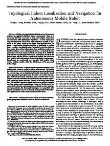
Map Building
perception
range readings
processing & fusion
robot position
maps Navigation
motion
path
planning
Fig. 1. The proposed solution approach
IEEE TRANSACTIONS ON SYSTEMS, MAN, AND CYBERNETICS, NO. Y, MONTH 1999
Fig. 2. The NOMAD 200 mobile robot.
114
IEEE TRANSACTIONS ON SYSTEMS, MAN, AND CYBERNETICS, NO. Y, MONTH 1999
start or from navigation process
perception { rik }
processing k
E ,O
k
fusion aggregation E,O map update
Mp , M m to navigation process Fig. 3. The k-th map building process.
115
IEEE TRANSACTIONS ON SYSTEMS, MAN, AND CYBERNETICS, NO. Y, MONTH 1999
116
radiation cone
radiation cone r
sensor
sensor
Fig. 4. Ultrasonic sensing: objects in different positions can give the same distance reading r (left); false reflections may occur for large angles of incidence (right).
IEEE TRANSACTIONS ON SYSTEMS, MAN, AND CYBERNETICS, NO. Y, MONTH 1999
117
kE
ρ r–∆r
r
kO
ρ r–∆r
r
r+∆r
Fig. 5. The two certainty functions fE (above) and fO (below) for a range reading r.
IEEE TRANSACTIONS ON SYSTEMS, MAN, AND CYBERNETICS, NO. Y, MONTH 1999
118
1
-12.5 ˚
12.5˚ Fig. 6. The modulation function m(ϑ).
ϑ
IEEE TRANSACTIONS ON SYSTEMS, MAN, AND CYBERNETICS, NO. Y, MONTH 1999
119
0
0.5
1
0
0.5
1 Fig. 7. Membership functions for m.
Eik
(above) and
Oik
(below) inside the sensor radiation cone. The sensor reading is assumed to be ri = 0.5
IEEE TRANSACTIONS ON SYSTEMS, MAN, AND CYBERNETICS, NO. Y, MONTH 1999
120
Fig. 8. The motion map Mm obtained for a stationary environment: darker areas correspond to higher values of µm . The actual profile of the corridor, the room and the obstacle are superimposed. White spots indicate the perception points.
IEEE TRANSACTIONS ON SYSTEMS, MAN, AND CYBERNETICS, NO. Y, MONTH 1999
from map building process
planning Pk
motion elementary step on P k
goal reached
Y
end
N stop condition
N
Y to map building process Fig. 9. The k-th navigation process.
121
IEEE TRANSACTIONS ON SYSTEMS, MAN, AND CYBERNETICS, NO. Y, MONTH 1999
122
G
S
Fig. 10. Simulation 1: Paths generated by A⋆1 and A⋆2 (continuous) and A⋆3 (dotted).
IEEE TRANSACTIONS ON SYSTEMS, MAN, AND CYBERNETICS, NO. Y, MONTH 1999
A⋆1 A⋆2 A⋆3
g1 21.80 21.80 45.50
g2 5.34 5.34 17.13
g3 0.50 0.50 0.50
cells in the path 121 121 145
expanded cells 2066 2394 378
TABLE I Results for Simulation 1.
123
computing time (sec) 3.13 6.21 0.08
IEEE TRANSACTIONS ON SYSTEMS, MAN, AND CYBERNETICS, NO. Y, MONTH 1999
S G
Fig. 11. Simulation 2: Paths generated by A⋆1 (continuous), A⋆2 (dashed) and A⋆3 (dotted).
124
IEEE TRANSACTIONS ON SYSTEMS, MAN, AND CYBERNETICS, NO. Y, MONTH 1999
A⋆1 A⋆2 A⋆3
g1 3.1 3.7 5.8
g2 1.43 0.69 1.22
g3 0.60 0.50 0.50
cells in the path 9 25 35
expanded cells 108 168 65
TABLE II Results for Simulation 2.
125
computing time (sec) 0.09 0.16 0.01
IEEE TRANSACTIONS ON SYSTEMS, MAN, AND CYBERNETICS, NO. Y, MONTH 1999
NOMAD
Fig. 12. Actual map of the most significant stationary obstacles inside the experiment area.
126
IEEE TRANSACTIONS ON SYSTEMS, MAN, AND CYBERNETICS, NO. Y, MONTH 1999
127
S G
Fig. 13. Experiment 1: NOMAD tries a direct path to the goal.
IEEE TRANSACTIONS ON SYSTEMS, MAN, AND CYBERNETICS, NO. Y, MONTH 1999
128
S G
Fig. 14. Experiment 1: A wall obstructing the direct path to the goal is detected.
IEEE TRANSACTIONS ON SYSTEMS, MAN, AND CYBERNETICS, NO. Y, MONTH 1999
129
S G
Fig. 15. Experiment 1: NOMAD tries an alternative path guided by the heuristic function of the A⋆2 planner.
IEEE TRANSACTIONS ON SYSTEMS, MAN, AND CYBERNETICS, NO. Y, MONTH 1999
130
S G
Fig. 16. Experiment 1: The final map and the path executed by NOMAD to reach the goal.
IEEE TRANSACTIONS ON SYSTEMS, MAN, AND CYBERNETICS, NO. Y, MONTH 1999
S
G
Fig. 17. Experiment 2: The channel is currently obstructed.
131
IEEE TRANSACTIONS ON SYSTEMS, MAN, AND CYBERNETICS, NO. Y, MONTH 1999
S
G
Fig. 18. Experiment 2: NOMAD tries to find an alternative path.
132
IEEE TRANSACTIONS ON SYSTEMS, MAN, AND CYBERNETICS, NO. Y, MONTH 1999
S
G
Fig. 19. Experiment 2: The channel is now free.
133
IEEE TRANSACTIONS ON SYSTEMS, MAN, AND CYBERNETICS, NO. Y, MONTH 1999
S
G
Fig. 20. Experiment 2: The final map and the path executed by NOMAD to reach the goal.
134
IEEE TRANSACTIONS ON SYSTEMS, MAN, AND CYBERNETICS, NO. Y, MONTH 1999
135
uλ (b,b,...,b) 1 0.8
0.5
λ= 0.3
0.7
0.9
0.6 0.4 0.2
iteration 1
2
3
4
5
Fig. 21. Behavior of the Dombi union operator for different values of λ. The dots show the result of the iterated application of uλ to the value b = 0.25.
List of Footnotes
Manuscript received. . . . . . . . . G. Oriolo and M. Vendittelli are with the Dipartimento di Informatica e Sistemistica, Universit` a degli Studi di Roma “La Sapienza”, Via Eudossiana 18, 00184 Rome, Italy. E-mails:
[email protected],
[email protected]. G. Ulivi is with the Dipartimento di Informatica e Automatica, Terza Universit` a degli Studi di Roma, Via della Vasca Navale 84, 00146 Rome, Italy. E-mail:
[email protected] . This work was partially supported by ENEA funds (Antarctica Project) and by ESPRIT BR Project 6546 (PROMotion). 1
Hereafter, we denote fuzzy sets by calligraphic capital letters.
2
By squaring the value of the membership function of E, the difference between low and high values is emphasized: according to the fuzzy logic terminology, we are applying the linguistic modifier ‘very’ to the ‘empty’ concept.
3
In the terminology of [27], g1 and g3 are respectively the power and the height of Mp over P k .
List of Figures 1 2 3 4 5 6 7 8
9 10 11 12 13 14 15 16 17 18 19 20 21
The proposed solution approach . . . . . . . . . . . . . . . . . . . . . . . . . . . . . . . . . . . . . . . . . . The NOMAD 200 mobile robot. . . . . . . . . . . . . . . . . . . . . . . . . . . . . . . . . . . . . . . . . . . The k-th map building process. . . . . . . . . . . . . . . . . . . . . . . . . . . . . . . . . . . . . . . . . . . Ultrasonic sensing: objects in different positions can give the same distance reading r (left); false reflections may occur for large angles of incidence (right). . . . . . . . . . . . . . . . . . . . . . . . . . . . . . . . . . . The two certainty functions fE (above) and fO (below) for a range reading r. . . . . . . . . . . . . . . . . The modulation function m(ϑ). . . . . . . . . . . . . . . . . . . . . . . . . . . . . . . . . . . . . . . . . . . Membership functions for Eik (above) and Oik (below) inside the sensor radiation cone. The sensor reading is assumed to be ri = 0.5 m. . . . . . . . . . . . . . . . . . . . . . . . . . . . . . . . . . . . . . . . . . . . . The motion map Mm obtained for a stationary environment: darker areas correspond to higher values of µm . The actual profile of the corridor, the room and the obstacle are superimposed. White spots indicate the perception points. . . . . . . . . . . . . . . . . . . . . . . . . . . . . . . . . . . . . . . . . . . . . . . . . The k-th navigation process. . . . . . . . . . . . . . . . . . . . . . . . . . . . . . . . . . . . . . . . . . . . . Simulation 1: Paths generated by A⋆1 and A⋆2 (continuous) and A⋆3 (dotted). . . . . . . . . . . . . . . . . . Simulation 2: Paths generated by A⋆1 (continuous), A⋆2 (dashed) and A⋆3 (dotted). . . . . . . . . . . . . . . Actual map of the most significant stationary obstacles inside the experiment area. . . . . . . . . . . . . . Experiment 1: NOMAD tries a direct path to the goal. . . . . . . . . . . . . . . . . . . . . . . . . . . . . . Experiment 1: A wall obstructing the direct path to the goal is detected. . . . . . . . . . . . . . . . . . . . Experiment 1: NOMAD tries an alternative path guided by the heuristic function of the A⋆2 planner. . . . Experiment 1: The final map and the path executed by NOMAD to reach the goal. . . . . . . . . . . . . . Experiment 2: The channel is currently obstructed. . . . . . . . . . . . . . . . . . . . . . . . . . . . . . . . Experiment 2: NOMAD tries to find an alternative path. . . . . . . . . . . . . . . . . . . . . . . . . . . . . Experiment 2: The channel is now free. . . . . . . . . . . . . . . . . . . . . . . . . . . . . . . . . . . . . . . Experiment 2: The final map and the path executed by NOMAD to reach the goal. . . . . . . . . . . . . . Behavior of the Dombi union operator for different values of λ. The dots show the result of the iterated application of uλ to the value b = 0.25. . . . . . . . . . . . . . . . . . . . . . . . . . . . . . . . . . . . . . .
113 114 115 116 117 118 119
120 121 122 124 126 127 128 129 130 131 132 133 134 135
List of Tables I II
Results for Simulation 1. . . . . . . . . . . . . . . . . . . . . . . . . . . . . . . . . . . . . . . . . . . . . . . Results for Simulation 2. . . . . . . . . . . . . . . . . . . . . . . . . . . . . . . . . . . . . . . . . . . . . . .
123 125