1
Refining WiFi Indoor Positioning Renders Pertinent Deploying Location-Based Multimedia Guide F. Lassabe, P. Canalda, D. Charlet, P. Chatonnay, F. Spies LIFC - Laboratoire d’Informatique de l’Universit´e de Franche-Comt´e Num´erica - Multimedia Developpement Center Cours Louis Leprince Ringuet, BP 21126 25201 Montb´eliard Cedex, France Email : {frederic.lassabe,philippe.canalda,pascal.chatonnay,francois.spies}@univ-fcomte.fr
[email protected]
Abstract If outdoor positioning is widely treated and quite precise, indoor or more generally in heterogeneous environment, the positioning (and also mobility prediction) requires consequent devices. The WiFi solution, easy to deploy and cheaper, becomes today an alternative. Our refinement approach, which is based on, both a friis calibrated model and the referenced points, makes it competitive. The targeted applications require not only deployment and precision, but also diffusion of rich and interactive media flow. Keywords : Indoor Positioning, WiFi Network, Friis-based calibrated model, Model by Refinement, Media Guide, Middleware, Multimedia Platform.
I. Introduction From time immemorial, technological convergences conduce to the emergence of new application. And today, with the spreading of wireless networks and their associated services, new problems bound to the mobility of the terminals arise. In particular, if outdoor positioning is widely treated and quite precise, indoor or more generally in heterogeneous environment, the positioning (and also mobility prediction) requires consequent devices. When compared to WiFi solution, GPS-extended’s solution, or sensor networks’ one (CarpetLan [1], infrared [2], ultrasounds [3]) are complex, time-consuming and expensive to be efficiently deployed and configured within an indoor environment. An approach to tackle the WiFi indoor
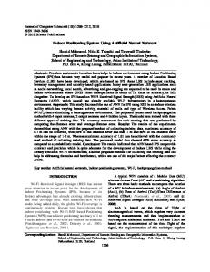
positioning is, first to partition a territory in recovering and homogeneous zones, second to locate and configure appropriately the access points, third to apply proved techniques to position a mobile terminal, and fourth to enhance the accuracy of the apparatus by hybrid (refining, learning, cognitive, ...) methods. Wireless networks are of various types : GSM, UMTS, WiFi [4], etc. The services provided are also numerous, from consulting web pages to watching on-demand video sequences. Because of these facts, it is natural to consider using a middleware to provide the positioning and mobility management. This way, the interface between the user’s applications and the service component (holding positioning, mobility, continuity, ...) is transparent. In this article, we present a service which aims at positioning efficiently a mobile terminal across a very heterogeneous building. Such a service is included in a set of components composed of : an indoor WiFi positioning system, a system learning the mobile terminal moves and a system using the data acquired to anticipate the service interruptions. The handover is managed by a protocol dedicated to the mobility. The service presented comes within the scope of a streaming platform of multimedia content. This project name is MoVie [5]. It is composed of 4 modules (fig. 1) : – NetMoVie integrates the RTP/RTCP protocol. It receives a few video sequence qualities and selects the most adapted one depending on the current situation. – SysMoVie gathers ORB components and integrates the hierarchy of video caches. The strategy of video cache management is specific to the particular temporal data. – WebMoVie represents a query interface of the MoVie
2
WebMoVie Database / Frontend
Clients
SysMoVie CLIENT
CLIENT
CLIENT
SERVER
SERVER
NetMoVie
Caches / mandataries CLIENT
Mixers
video Servers
SERVER SERVER
GeoMoVie Positioning and Mobility Prediction
Fig. 1. MoVie structure. platform. It is the entry point of clients where they are identified. A trader is used for each query in order to localize one or more required video sequences in SysMoVie. – GeoMoVie [6] tracks the mobile clients and anticipates their future moves. It contains positioning and prediction modules. It also provides the handover management. First, we present the work related to positioning systems. We expose the main approaches and techniques range from discrete’s ones (referenced points, Viterbi-like, ...) to continues’ ones (Friis formula, Signal Strength (SS) Measurement, ...). Then, we expose our contributions which handle continuous positioning. Our work is complementary to those concerned with simulation of SS Propagation, and positioning of access points [7]. We present our Friisbased Calibrated Model (FBCM), then enhanced with a refinement based on referenced points and Viterbi-like algorithm. Third, wedescribe the experiments for which the results are analysed, and we conclude with future trends.
II. Related Work and their Drawbacks In this section, we present on the one hand the major related wireless positioning models and approaches, and on the other hand those positioning systems based on the WiFi technology. The GPS [8] is the system allowing locating an apparatus on the surface of the planet or in the atmosphere, using reference satellites whose positions are known. This system has been essential for several years. Thanks to preliminary synchronization of the satellites with the GPS receiver, the latter can compute, based on the time of course between the satellites and the receiver, the distance separating it from each satellite. By trilateration [9], it means the intersection of the spheres determined by the distances between the mobile device and each satellite, the receiver’s position is calculated. The precision is about
5 meters for civil applications. GPS is very accurate compared to the movement speed of the vehicles and the scale of positioning. The main drawback is it does not function well enough indoors, in city centers, or in raised or leafy environments. GSM, standing for Global System for Mobile Communication, is the main mobile telephony standard in use. This standard has given birth to three positioning methods. For each method, setup and accuracy vary. The methods are the positioning by cell, the computation of the distance according to the SS and the distance computation by time difference. The positioning by cell is basic. Interrogating the BTS (Base Transmitting Station) is sufficient to identify to which one the mobile is connected. The mobile phone is located in the cover area of the said BTS. This method has a variable accuracy, from 100 meters to several miles (depending on the cell size, itself depending on the mobile phones density). In cases where a service like calling the mobile phone is provided, such accuracy is enough. The positioning by measuring the SS requires the knowledge of the radio wave weakening according to the distance between the transmitter and the receiver. Then, the distances toward the BTS can be extrapolated by measuring the SS. With the distances toward the BTS (whose positions are known), the trilateration mechanism gives the position of the mobile phone. The accuracy obtained is between 50 and 500 meters. Enhanced Observed Time Difference (EOTD) is a method to estimate the time for the signal to go from the mobile phone to the BTS. This technique is usually employed to adapt the transmission timing of the mobile phones according to their distance to the BTS, thus allowing the scheduling of the packets in the time slots. Without this method, the packets would collide near the BTS. The adaptation of the transmission timing is called Timing Advance. It requires the synchronization of the BTS and the mobile phones. The distance computation with the time difference is based on EOTD to compute the distance between the BTS and the mobile phone. Knowing the time used by the signal to go from the mobile to the BTS and the wave speed, we can compute the distance. Then, trilateration gives the position of the mobile phone. The course time of the wave is not usable to position WiFi indoor terminals because the distances involved are too short. In addition, too many obstacles, which slow down the wave [10], occur in the buildings. Wifi positioning techniques can be classified into two main categories, the one based on SS cartography, and the other which determines a relation between SS and distance. Determining the distances between known points and the mobile terminal makes the location computation possible using trilateration. Within the RADAR system [11], the
mobile terminal positioning uses a SS map of the covered area. The geographic coordinates, the SS measurements and the mobile orientation are stored in a database. The SS map can either be constituted by computation or by physical measurements. The SS measurement from each access point is compared with the referenced points stored in the database. Further works [12] use a Viterbi-like algorithm to improve the accuracy by using the history of the previous locations of the mobile terminal. The RADAR project provides positioning with accuracy. When measuring the SS map, even if the accuracy is better, it remains several drawbacks : the high setup time cost and the lack of dynamics. When the SS map is computed, the system is dynamic but the accuracy is lower. Wang, Jia and Lee [13] present a positioning technique based on a radio wave propagation model. This model aims at expressing the mathematical relation between the distance from transmitter to receiver and the SS. The mathematical expression is obtained by polynomial regression of the third degree. The advantage of this technique is the speed of positioning. However, a lot of data are required for the regression to be accurate, which involves a high cost in measurement time. This project provides a positioning accuracy of about 1 to 3 meters. Many measurements are required to determine the relation between the distance and the SS. Hence if its use is immediate and simple (the polynomial expression returns a distance), it remains that the model is not dynamic. With at least 3 distances, trilateration allows the mobile terminal to be positioned. On top of that, it is possible to be confronted with singularities (due to massive reflection, refraction, absorption, attenuation of SS) in the buildings where the positioning technique is implemented. The white paper of Interlink Networks [14] deals with security issues. Its first objective is to locate rogue mobile terminals and access points which try to infiltrate a network through its wireless part. The authors take SS measurements at many locations of many buildings. The results of these measurements are used to establish a radio wave propagation model. This model is based on the Friis relation, defined by : λ 2 PR = G R GT ( ) PT 4πd where : – PR and PT are respectively the SS received and the SS emitted ; – GR and GT are respectively the receiver and transmitter antennas gains ; – λ is the carrier wavelength ; – d is the distance between the receiver and the transmitter. The Friis relation expresses the SS in function of distance, in a free space environment. The Friis-based model is
3
adapted to fit the conditions of implementation. The precision observed is close to 2 meters. The main advantage of this technique is its setup speed. However, some singular geographic points were observed where the precision was worse than 8 meters. These singular points are explained by the topology of the buildings. The main drawback of this technique is the unique exponent used in the Friis equation, which only fits the average building heterogeneity.
III. Contributions As exposed above, several positioning techniques already exist, but all suffer from one or more drawbacks. We aim at determining a mobile terminal’s position with enough accuracy to allow the use of context-aware services. After presenting the Friis-based Calibrated Model (FBCM) from which we study the limits, we define the reference-based model we used, and its improvements. Finally, we present an hybrid/refining model, gathering the advantages of both the referenced points-based and Friisbased techniques.
A. Friis-based Calibrated Model (FBCM) In [15], we present a distance computation-based model to locate mobile terminals. The FBCM aims at adapting the wave propagation model to its environment, by performing 3 steps. First, some measurements are taken in the targeted floor of the building. Second, the measurements are exploited to compute an index in the alternative of the Friis equation. Thus, the index is fitted to the floor where the measurements were taken. And third, the index computed is the one used in the alternative of the Friis equation in order to compute the distance between each access point and the mobile. We discuss further improvements to the FBCM, such as computing an index for each access point and clustering the floors into homogeneous areas where we could apply a different index for each one. Experiments were carried out to test our model’s accuracy. In the experiments, we implement the FBCM, the polynomial regression and the Interlink Networks’ technique. The results are listed in table I. The first value is the mean error and the second value (parenthesised one) is the standard deviation. Although the results of our FBCM are better than other techniques ([13], [14]), they are not sufficient to provide location-aware services in the scope of a building. Our testbed is very heterogeneous. As we can see on the map (see fig. 2), the building is separated in two parts by a load-bearing wall. One side contains offices separated by walls. On the other side, there is a corridor. Obstacles like the walls and the load bearing wall, weaken the SS more
Technique Polynomial regression Interlink Networks FBCM
Calibration floor error (in m.) 22.78 (14.07)
Other tests (y/n) n
Global error (in m.) 22.78 (14.07)
29.38 (12.17)
y
32.47 (9.61)
15.86 (9.34)
y
22.92 (11.06)
32,6 m
TABLE I. Comparison between the Indoor FBCM’s accuracy and that of other major distance approximation techniques
4
Studying the optimal placement of the referenced points remains an open topic [7]. The positioning system begins functioning like RADAR : the SS samples are compared to the reference measurements’ set. A predefined number of points are selected and the Viterbi-like algorithm is run on the so-created set. The first improvement to the RADAR system is made within the Viterbi algorithm. The distances in the Viterbi algorithm are euclidean distances between points. We added a logical layer to specify the connexity between the points. Indeed, euclidean distances do not take the topological elements into account. Thus, it seems possible to the system that a person goes through a wall. When specified, the distance is either infinite or considers the course needed to go from a side of the wall to the other side. The algorithm to compute the distances requires that, for each point on a given floor, we give its neighborhood (points directly connected to it). This is specified with a squared matrix containing 1 for an existing connexity and 0 for no connexity. Then, for each 1 of the matrix, the euclidean distance is computed because points directly connected are separated by their euclidean distance. The last step is an iterative algorithm to compute the remaining distances by adding the distance from the current point to its neighbor to the distance between the neighbor and its own neighbors. We iterate the later until the matrix is full.
C. Hybrid FBCM-Refinement model
(0,0)
10.5 m
First Floor
Fig. 2. First floor of the ISTI WiFi Network of Numerica. than the atmosphere. These properties explain the lack of accuracy in our tests of the FBCM. Such a precision is insufficient to locate precisely a mobile terminal indoors. On the map, the dots are the referenced points, the triangles are the access points on the floor and the crosses are the points where the positioning was tested.
B. Logical layer in the RADAR system We use an hybrid model by crossing the referenced point method and the wave propagation model one. The first step is based on the RADAR model. Several data are stored for each referenced point : physical coordinates, floor and a list of the access points and their SS. The data are stored in a database. We store approximately a point for each room, and one every 5 meters in corridors.
The main drawback, when using referenced points, is to reduce a continue space to a discrete space so it can be handled by a computer. If we want a good accuracy, we cannot only reduce buildings and floors to a chosen number of points. Thus, the use of FBCM allows improving the accuracy. Furthermore, the use of a FBCM-based adjustment leads to improve the result of the positioning system according to the access points of which we know the coordinates and the output power. In such a way, and once obtained a first positioning location, we select the referenced points in its neighborhood (an arbitrary distance defines the neighborhood). For each point, including the point chosen, a new distance toward the supposed location of the mobile is computed, based on data deduced from referenced points process. The computation of the distance requires to compute the Friis-based calibrated model’s index for each point. The index is used in the Friis-based equation to compute the distance toward the access point. Then, we consider the absolute value of the difference between the distance computed and the real distance. The real distance is known as the coordinates of both the referenced points and the access points used are known. Given the coordinates and the distances toward several points, that makes possible to
determine the position by trilateration. Distances greater than a given threshold are ignored in the trilateration process.
IV. Experiments Experiments have been carried out in order to validate our positioning model by refinement based on our Friisbased calibrated model and on referenced points. We focused our tests on WiFi positioning mobile terminals within an heterogeneous building. At this step, it is necessary to mention that our current study is involved in an overall project. Hence, when tackling applications, concerned with rich media streaming and video on demand services, and dedicated to mobile users connected to a WiFi networks, it becomes obvious to study mobility prediction and to impact the management of handof or cache management [16]. Then in the sequel, first we present the architecture of a mobility management middleware. Second we describe the context in which the calibrated model was tested and we continue by giving the test results. And third the results are discussed in an accuracy analysis.
A. GuiNuMo architecture GuiNuMo stands for Guide Num´erique Mobile (Mobile Digital Guide). It aims at providing media in concern with the user’s location in museums. GuiNuMo is a clientserver application currently written in C language, helped by PostgreSQL for the database part. Both the client and the server run under Linux. The client is installed on the mobile terminals provided to the tourists. The server is set on a dedicated machine. As explained in [11], GuiNuMo needs an offline training to create the database of referenced points. The current version of the GuiNuMo client makes the SS measurements and transmit it to the server. The server computes the location by matching the measurements sample to the reference data. It returns the mobile’s location which determines which media will be downloaded to and played on the client. The server is multithreaded to handle numerous clients.
B. Logical layer testing First we tested the impact of the logical layer on the accuracy of the referenced point-based system. The results are shown in table II. In table II, the first column states the real coordinates of the points where the logical layer was tested. An important information is the continuity information. When the test is not continue, it means that the program was reset between the previous test and the current one (thus resetting the Viterbi-related data to zero). When it is continue, it means
True coordinates (5.8,4.4) no continuity (8.6,14.5) continuity (7.6,25.2) continuity (7.8,21.4) no continuity (7.6,25.2) no continuity
Positioning
Nb
(4,5.4) (7.7,6) (7.8,21.4) (8.4,12.5) (8.5,16.6) (7.8,21.4) (8.5,16.6) (7.7,6) (8.5,16.6) (7.8,21.4)
3 2 1 3 1 2 3 1 4 5
Single error 2.1 2.6 7 2.1 2 4 8.6 8.5 2 3.8
Global error 2.4 (2.6)
5
3.06 (4.62) 6.76 (7.98) 3.3 (4.16) 3.8 (5.5)
TABLE II. Logical layer evaluation. that the program was just frozen between two points of test (keeping the data of the Viterbi algorithm). The second column gives the coordinates of the point returned by the positioning system (5 results for each point due to the depth of the Viterbi algorithm). The third column gives the number of results for each. The fourth column gives the error in meters between real coordinates and the result. The fifth column gives the mean error and (between parenthesis) the error observed in previous tests without the logical layer. We draw various conclusions from these results. First, we see that the Viterbi algorithm implies errors when used continuously. Although its goal is to reduce errors by running continuously, the explanation is simple : in our tests, the state of the program is frozen between two tests. Thus, unknown time and distance are running. From the Viterbi algorithm’s point of view, the time between two tests is considered being 1 second (in our case). The error comes from the teleportation (from the algorithm’s point of view) of the mobile terminal between two tests. Second, we can conclude that the logical layer slightly enhances the accuracy of the positioning system. Third, we can globally conclude that referenced points-based positioning systems are more suited to indoor use than propagation modelbased systems.
C. FBCM-Refinement (FBCM-R) testing Using the same points than in the test of the logical layer, we evaluate the hybrid model. The results shown in table III enlight the improvement of the positioning system accuracy. The calculations were done following the FBCM-based algorithm. Even considering the heterogeneity of the building, such an accuracy is satisfactory to be applied to location-based services. There is only one critical point. When performing numerous tests, although the errors does not exceed 1.2 meters, it may happen that the computed position correspond to a joint room. Such cases (to be solved) may require either a better density of
referenced points, or more WiFi access points to be more accurately located. True coordinates (5.8,4.4) (7.8,21.4) (7.6,25.2)
Positioning (6,3.2) (8.6,13.4) (7.6,24.6)
Error (meters) 1.2 1.3 0.7
TABLE III. FBCM Refinement evaluation.
V. Conclusions We presented a WiFi positioning method well suited to locate mobile terminals within an heterogeneous environment. The Friis-based Calibrated Model, when applied to homogeneous zones (which compose a recovering of the initial heterogeneous zone), and combined with referenced points refinement, such implemented approach provides a better positioning accuracy. We validated the pertinence of a WiFi indoor positioning, with an accuracy from 15 cm to 1,50 m, and only requiring an apparatus composed of 4 access points well disseminated within a 3 floors’ building. The calibration process is not time consuming. The density of referenced points and the number and positioning of access points are obviously correlated to accuracy. Such service is integrated into Movie platform and also to the GuiNuMo application’s experimentation. It constitutes the primer component of a middleware of mobility management. Thus, as WiFi is chosen because of its public accessibility and its high bandwidth for data transfer, our apparatus allows to combined positioning with delivering multimedia and interactive communications. Hence, we succeeded when deploying a Multimedia Guide (GuiNuMo) which proved the adequacy of combining positioning and prediction of mobility, predictive handof, predictive cache management, and adaptative and on-demand rich media diffusion.
VI. Future works and connections Our validated approach opens and leads to numerous extensions and perspectives. Some of them constitute direct extension to the work presented either to enhance the accuracy or make flexible the use of the positioning component. Others address partitioning territories, mobility prediction, and continuity services. Concerning the former point, we plan to apply the Friisbased enhancement to the set of points chosen before running the Viterbi-like algorithm. The goal is to enhance
6
the precision by avoiding the ’sticky’ behavior of the Viterbi-like algorithm. Another improvement to the Friis-based calibrated model’s use is to build an algorithm able to adjust the coordinates when the access points’ coordinates and output power are unknown. Such an improvement is possible by using the comparison between the signal strength at the point chosen and those of its neighborhood. We also plan to use multi-dimensional communicating automate (spatial, temporal, service-solicitation). For simplest example, a communicating automate can represent the different floors and the connexities between them (stairs, etc.). To make it possible, we have to find a fine grained representation to use pathfinding algorithm quickly in order to compute the distances between points located on different floors. Concerning the latter point, proposals in the field of mobility prediction are concurrently, in development (for the more advanced trends), and experimented inside the Mus´ee de l’Aventure Peugeot. A simulator for generating peregrination of the mobile terminals must be interfaced with the mobility management middleware. We also plan to handle mobility patterns. Last but not least, our works deal with the requirements and the solutions to address the service continuity in mobility. These requirements (streaming quality adapter, predictive cache management) are systematically integrated in a mobility management middleware ”‘GeoMoVie”’, the mobility component in a multimedia content streaming platform. To provide the service continuity, the mechanism called handover is used. It requires an anticipation, which is realized through mobility prediction. The handover is done transparently by an adapted protocol. It remains a long term issue, but that is not exclusive [16], which is to address vertical handoff.
References [1] M. Fukumoto and M. Shinagawa. Carpetlan : A novel indoor wireless(-like) networking and positioning system. In Proceedings of the 7th International Conference on Ubiquitous Computing (UbiComp 2005), pages 1–18, September 2005. [2] A. Ward, A. Jones, and A. Harper. A new location technique for the active office. IEEE Personnal Communications, 4(5) :42–47, October 1997. [3] N. B. Priyantha, A. Chakaborty, and H. Balakrishnan. The cricket location-support system. In Proceedings of the 6th Annual ACM International Conference on Mobile Computing and Networking (MobiCom 2000), pages 32–43, August 2000. [4] B.P. Crow, I. Widjaja, J.G. Kim, and P. Sakai. IEEE 802.11 Wireless Local Area Networks. IEEE Communications Magazine, 35(9) :116–126, September 1997. [5] J. Bourgeois, E. Mory, and F. Spies. Video transmission adaptation on mobile devices. Journal of Systems Architecture, 49 :475–484, 2003.
[6] D. Charlet, P. Chatonnay, and F. Spies. Hand-over video cache policy for mobile users. In J.B. Stefani, I. Demeure, and D. Hagimont, editors, Proceedings of 6th IFIP International Conference on Distributed Applications and Interoperable Systems (DAIS 03), volume LNCS 2893, pages 176–186, 2003. [7] K. Runser, E. Jullo, and J.-M. Gorce. Wireless lan planning using the multi-resolution fdpf propagation model. In Proceedings of the 12th International Conference on Antennas and Propagation, volume 1, pages 80–83, April 2003. [8] US Army Corps of Engineer, editor. Engineering and Design NAVSTAR Global Positioning System Surveying. Number EM 11101-1003. Department of the Army, Washington, DC, July 2003. [9] B.T. Fang. Trilateration and extension to global positioning system navigation. Journal of Guidance, Control, and Dynamics, 9 :715– 717, December 1986. [10] B. Mac Larnon. TAPR’s Spread Spectrum Update, chapter VHF/UHF/Microwave Radio Propagation : A Primer for Digital Experimenters. Tucson Amateur Packet Radio Corporation, 1998. [11] P. Bahl and V. N. Padmanabhan. RADAR : An in-building RFbased user location and tracking system. In INFOCOM (2), pages 775–784, 2000. [12] P. Bahl, A. Balachandran, and V. Padmanabhan. Enhancements to the radar user location and tracking system. Technical report, 2000. [13] Y. Wang, X. Jia, and H.K Lee. An indoors wireless positioning system based on wireless local area network infrastructure. In 6th Int. Symp. on Satellite Navigation Technology Including Mobile Positioning & Location Services, number paper 54, Melbourne, July 2003. CD-ROM proc. [14] Interlink Networks, Inc. A practical approach to identifying and tracking unauthorized 802.11 cards and access points. Technical report, 2002. [15] F. Lassabe, O. Baala, P. Canalda, P. Chatonnay, and F. Spies. A friis-based calibrated model for wifi terminals positioning. In Proceedings of IEEE Int. Symp. on a World of Wireless, Mobile and Multimedia Networks (WoWMoM 2005), June 2005. [16] D. Charlet, F. Lassabe, P. Canalda, P. Chatonnay, and F. Spies. Mobility prediction for multimedia services. In I. K. Ibrahim and Johannes Kepler University Linz, editors, Handbook of Research in Mobile Multimedia, chapter ***. Idea Group Inc., 2006. ISBN : 1591408660, 25 pages, to appear in 2006.
7