25. Remote Sensing and Coastal-zone. Management. The objective of this
chapter is to give several examples specific to coastal environments, based on.
Applications
25 Remote Sensing and Coastal-zone Management
415
multitemporal. Thus in metropolitan France for example, the basic geographic maps pertaining to Jiltoral zones are of various types, various scales and adopted to vanous planes of projectJ~n: ex. topographic maps of the National Geographic Institute, marine maps of the Naval Oceanographic and Hydrographic Service. . . In many tropical-zone countries, very few precise and up-to-date cartographic systems are available, particularly for sensitive and inaccessible regions such as mangroves and coral reefs.
25.2 SPATIAL OBSERVATION OF COASTAL ENVIRONMENTS 25.2.1 Littoral and coastal-zone objects It is difficult to define what constitutes the littoral zone since the phenomena pertaining to this interface
The objective of this chapter is to give several examples specific to coastal environments, based on the investigations carried out in France and in particular at the IFREMER.
25.1 INTRODUCTION: GENERAL PROBLEM Land cover and land use of coastal regions are today undergoing rapid changes, more particularly in countries producing and exporting petroleum or mineral products. Other modes of coastal exploitation have also become preponderant. Aquaculture is fast developing as is evident from the fact that 200,000 ha of ponds have been constructed in fragile zones on the Philippine coast. Similarly, tourism has increased in the Ancient World and some island states of the Caribbean, Pacific or Indian Ocean. In the near future tourist activity will become world's premier industry in terms of volume of business. In almost all countries with a maritime front, there is migration of populations to the coasts: 213 of world's population lives within 400 km from the sea. The impact of such activity is represented by: -development of infrastructure: ports, airports, industrial, mining and energy complexes, offshore petroleum production, agro-nutritiona! transformation, urban complexes, hotel and tourist infrastructure, aquacu!tural installations, etc. -transformation of natural zones: destruction of wet zones, reefs, natural vegetation in back lands, rectification and protection of coastline, various types of pollution of marine environment, increase in ecological hazards, etc. Increasing awareness of such hazards and. the need for more efficient management are experienced at all levels and are concretised by co-ordinated management procedures which most often are supported by legislation: -in France, schemes for economic management of seas (SMVM), more recently territorial management directives (DTA), -in the United States, the Coastal Management Act, Middle Atlantic Coastal Resource Council, -at international level, programmes such as COMAR (UNESCO), Regional Seas (PNUE), etc. The European Union, concerned with this problem very early, launched specific experiments on information and integrated studies on coastal zones. Such legislations and procedures necessitate employment of planning and management products derived from multiparameter information systems for which remote sensing constitutes a source of data. Coastal zones present the difficulty of linear type of extension with a land-sea interface and its adjacent zones in all countries, independent of borders. This interface .is under the jurisdiction of several administrations whose prerogatives are often opposed to one other. Further, like in applications described in other chapters, information furnished ought to be multispatiat, multiparametric and
are both terrestrial and marine. From an administrative point of view, the extension of the coastal zone on the upstream, ~eastland, side can be limited to the border of litioral communities and on the downstream (sea) Side, to 12 nautical miles. Based on environmental criteria related to water exchanges and flows, it can be considered to extend from the inland boundaries of watersheds up to the zone of extension of these flows into the sea. on the geographic and topographic basis, it can range from a land zone of a defined elevation (200m for example) to the border of cont'in~ntalplateau (bathyn;etnc limit of -200 m). For the following discussions, we limit ourselves to the manne littoral zone_, r.e.,_ to the zone bounded on the land by high-tide mark. Two types of envrronment can be diStinguished in thiS zone. -subtidal, situated below low-tide level; venue of influences, often combmed With one another, emerging: (a) from the surface (sea swell, waves, currents, winds, pollutants such as hydrocarbons, ice, etc.), (b) from the water column (turbidity, temperature, discharge plumes,water blooms, plankton, etc.), (c) from the bottom (shallow areas floors observed in clearwater in optical domain, themselves consisting of various substrata, hard or soft, with or without vegetation, emergmg from anrmal constructions such as coral reefs and with influence of the sea bottom on surface currents, detectable in the microwave band, etc.). -intertidal, situated in the balance zone of tides, comprising bare soils (sands, mud, rocks, _etc.), vegetation (plants in swamps such as mangroves, marine halophytes, algae, microflora, etc.), anrmals (mollusk banks, coral reefs, etc.), managed zones (oyster parks, basins, canals, breeding ponds, salt pans, etc.). . . In addition to a general linear disposition, the littoral zones are charactensed by small-SiZe features constituting highly varied landscapes whose structure results from natural or artificial processes. Lastly, the constituents of the littoral zones are highly fluctuating With vaned penodicity, random (storms for example) or periodic (hydrological regimes, phenological regimes, tides, etc.). Considering these features, it is pertinent to examme whether the Earth-observation systems possess adequate spatial resolution and observational periodicity to provtde, on operational basts, data necessary for correct characterisation of surtace phenomena tn l1ttoral zones, as complementary to conventional ground measurements.
25.2.2 Littoral objects and specifications of aerospatial observation systems Preliminary analyses of adequacy between characteristics of coastal environments and technical performance of aerospatial observation systems (Kiemas et al., 1980; Gterloff-Emden, 1982, Loubersac, 1983; Klemas et al., 1987) have shown that present-day remote-sensing systems are not correctly
416
Processing of Remote Sensing Data
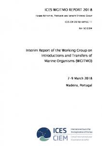
suited for coastal-zone studies. There is incomp fbTt b · · . resolution required for these observations. Thi: :s ~~~a~:~~~,:~~~~~~~~ resol~~lon and high temporal resolutJ_o~ remote ~e~_sin_g to coastal investigations that do not involved e~~n~i e appltcatton of highThiS Incompatibility IS illustrated in Fi 25 1 An n . . y c phenomena. temporal resolution expressed in days (abs~iss~) ~nd s~a~·lylsls oil the diagram (logarithmic scales) of offered by major Earth observation systems leads to th- floalloreso utlofn expressed tn metres (ordinate) 1e wmg 1n erences. Spa hal
resolu!lon{m)
Applications
417
The optimal temporal resolution, extremely variable depending on the application, is not satisfied by the presently existing satellite systems (better than 3 days with ERS lor typical coastal studies). Thus operational applications of remote sensing to tidal phenomena, monitoring of dispersion due to currents and winds (dispersion of wastes, resulting pollutants, etc.) or navigation control are most often limited. Aerial platforms are better suited for coastal studies since they provide ground resolution and revisit frequency higher than those of today's high-performance satellites and permit a greater number of onboard sensors. However, the disadvantages of aerial systems are limited synoplic view, high costs of acquisition with increasing repetition, atmospheric constraints and tedious procedures of geometric processing of data. Operational characteristics of the major satellite or airborne sensors for various studies of coastal zones are summarised in Table 25.1 (adapted alter Klemas et al., 1987). Use of certain plartorms for some sensors is not technically feasible and hence not indicated. It follows from the Table that optimal observation lor monitoring coastal phenomena necessitates use of almost all the spectral bands and
10'
Table 25.1 Operational characteristics of remote·sensing systems for coastal studies
MjTjOSAT {lR) - - -
NOAA-TlAOS-SEAWIFS
"
.Q
10'
[ii
c
1l
ENV!SAT/MEAIS - -
Sensor
LANDSAT (o'viSS} - - 10'
LANDSAT(TM)--
E
~ 0::
8"
m
-g
3
>-
" E E ~ OJ~ "0
SPOT 1-4 (XS) EAS {SAR PR1) - -
~
SPOT 1-4 (P) AOEOS - - - lO'
~
!AS-SPOi5--
~
"
.Q
I ~
c.
5 G
m m
a
£
m
.§
~
m m
~
" 0
~ 0
~ I
"S
"
·~
~
;;
1(j 0
(.)
" "
"0
-"1 "0
""' "
I.g;
01
2
G
m m ~
iJl
;;;
S!2. 0
m
m
>
§
g
E '5
~
;;;
0
-g
iii 1il
m m
§
~
c. ~
;; en ~
5
;;
:;;
c.
E .!l
~
" "' "§1J" (/)
m m
"'
E
(/)
0
(/)
ii5
(/)
OABVIEWJ-.OUICKB!RO - - 10'
10"
r
METEOSAT (112h)
t tu
NOAA-TIAOS (12h)
10'
t
EAS
10'
uqERS (35 d)
10'
Days
J
/IORBVIEW3/1 SPOT(24d) (J d} OUICKBIRO (20 d J
SEAWIFS (24 h)
ENVISATf(~~A~~
A
A
s Multispectral
A
scanners
s
Imaging
A
radar
s
!R thermal
A
scanners Passive microwave
s
radiometers
s s
;~=~~:ti~~~~t~~~i;c~l~caose
a
A
(Vis. Lat. 2-5 d.)
The spatial resolution (tens of metres) of t h operational characterisation of some of the ~~~=~~stu\ as S~OT or ERS enables with difficulty · phenomena such as coastal 8 . ~ lVI leS m lttoral zones and certain natural the other hand, the very high of strong sedimentary dynamics). On metre in panchromatic) and Quickbird (3 3 d 0 r Orbvlew-3 (4 m tn multispectral and a requirements for most applications in coastal :~nes.· m respectively) are closer to the resolution
~1
s ~
SPOT LANDSAT (18 d) OUICKBIRO
Fig. 25.1: Possibility of detection of marine and co3s•a1 heno · Earth observation satellites {adapted completed a ld p d t md enf a by maJor sensors and platforms of present·day • n up a e a ter Klemas et al., 1987, courtesy IFREMER).
i )
Radar altimeter Profiling lasers Laser fluorescence Photography
Radar scatterometer
0
D D
:~~·:~:;
~ ~ ~
~
II
a 0
2 2
~
0
a a
01
~
1131 1131 1131 a 1131
aDl Dl iiiD IIn
~
•• • a
a D D a D a
~j
a
~··,:
,:.·
n
~
II
0
~
0
D
0
a
a
~li
Dl
A
•
0
0
0
0
0
~
0
0
-,,
0
D
.. :2X};
0
A-Aeroplane; $-Satellite; 4-0perationai; 3-Truly potential but experimentation required; 2-Potentia! utility; 1-Limited utility; Q-Not usable
418
Applications
Processing of Remote Sensing Data
all types available sensors, without however enabling presently reliable measurement of an important hydrological parameter such as salinity. An optimum but technically difficult solution would be to combine a multispectral scanner, a thermal scanner, a radar (especially imaging one] and a microwave radiometer, all with a spatial resolution of less than 5 m and a revisit capability of a day or less, on a single plaiform or on different platforms operating in phase. The presently available multispectral data of optical and thermal bands and the SAR type radar offer great potential for a number oi applications, some of which are given below.
II
419
Macrophyte algae
Compared to other higher forms of vegetation, algae show a large pigment diversity adapted to the variability of their luminous environment (Levavasseur, 1986). Studies of various algae groups (green, red, brown) show a low response between 400 and 500 nm (absorption by chlorophyll) and absolute values of reflectance, beyond 700 nm, dependect on the conditions of light, cover and degree of immersion. In the region 500-700 nm, reflectance indicates the diversity of pigments present (Fig. 25.2).
25.3 SPECTRAL CHARACTERISTICS OF LITTORAL OBJECTS
, Himantalia r:./ongata C/JOndflJS cnspus
40
(Rhodophycae)
~~ {Pheophycae)
~---
__
/
Spectral responses of a water layer are given in Chapter 4 for optical domain and in Chapter 1 for thermal infrared and microwave bands. Examples of application of thermal and microwave data are discussed in Chapter 26. Spectral charact8ristics of objects of the maritime region in intertidal and subtidal zones are described below.
;1'
-
-----
·30
0
ro
u
-" cr:
'"
20
25.3.1 Intertidal and subtidal littoral environments The intertidal littoral zone generally constitutes a 'mosaic' of various biological communities, substrata of varied geology and grain-size, moisture gradients associated with inundation and exudation, all disturbed by human activity (marine cultures, salt pans, various management activities, etc.). Varied pixels and mixels represent these features. The subtidal environments correspond to littoral zones permanently inundated by brine or seawater. The spectral response oi the sea depends on the content of sediments or pigments (water colour), nature of sea floor, action of surface wind, storms, currents, pollution, etc.
25.3.2 Mineral targets of intertidal zone (optical domain) 'Pure' mineral targets such as sands, muddy sands, mud and rocks exhibit monotonous spectral characteristics between blue-violet and near-infrared (see Chaps. 4 and 23). Only level variations are detectable, ~vhich result from a number of factors such as natural colour of the substratum, water content, organic matter, grain size, etc. Contrarily, the spectral response of sediments may be considerably modified by suriace deposition of biological matter such as diatoms, indicating the presence of microphytobenthos. Guillaumont et al. (1988) have shown that modification in spectral response in the presence of a microflora is directly related to the content of pigments (chlorophyll and phaeopigments). Such a result is significant since microphytobenthos, with phytoplankton and macrophyte algae, contributes to the primary production of coastal ecosystems, in particular in areas where muddy-sandy stretches exposed to low tides are vast. Their temporal variation is very high and the conventional methods of observation and measurement are difficult to employ.
10
Wavelength (nm} I
500
700
BOO
900
Fig. 25.2: Example of spectral reflectance curves of various algae groups (after Guillaumont, 1991 ).
Although the range of variation is small, Viollier et al. (1985) have shown that this diversity of pigments can be detected in wide bands of a HRV type sensor, which give the index XS1/XS2 (see Chap. 4). This index can be used to differentiate major vegetal populations, provided it is verified that the pixels analysed fulfil the condition of 'pure' target. Using airborne remote-sensing data of high spatial (pixel < 5 m) and spectral resolutions and supported by detailed ground spectroradiometric surveys, Bajjouk et al. (1996) have shown that the 13 spectral bands of the CAS I airborne imaging spectroradiometer, programmable for position and width of spectra (see Chap. 2), can be optimally selected for discriminating major macroalgae of the North Bretagne tidal flats. These positions representative of the principal species are shown in Fig. 25.3, with superposition of ground spectral curves. On the other hand, specific growth of vegetal fronds and especially the horizontal disposition of thallus and large density of leaf canopy of algae hinder penetration of sunlight into depth. Thus, for brown algae, Ben Moussa (1987) has shown that normalised vegetation index (NDVI) reaches its maximum from a thallus density of 4 (density attained quasi-systematically in situ). A review by Guillaumont et al. (1997] gives more information on principles and methods of remote sensing of macrophyte algae.
25.3.3 Vegetal targets of intertidal zone (optical domain) II
Spectral characteristics oi intertidal vegetation are similar to those of terrestrial vegetation discussed in Chapter 4. Three classes of intertidal vegetation are distinguished: macrophyte algae, marine phanerogams and swamp halophytes.
600
Marine phanerogams
These flower plants colonise sandy and muddy-sand zones, sometimes constituting large areas in tropical regions (turtle grass). They show in emergence a planophylic posture like macrophyte algae. In the case of seaweeds, a significant correlation is observed between biomass and normalised
420
Processing of Remote Sensing Data
A
:r 50 40
j_ -
Applications Reflectance(%)
~I I~I ~~~r /I! Ill
I
I ,, I rJ
1 11 ''
/I
//
0.9
25
0.8
20
0.7
15
0.6 0.5
•1Q
0.4
I 5
0.3
/ ///11
::tl· i I
lrli/111,!
lk~lli,~L
450
550
7 May
1 June
2 July
5 August 16 September 1987
Fig. 25.4: Seasonal variation of reflectance of Scripus maritimus-Cime! radiometer (after Gui!Jaumont, 1991).
II
For the European maritime swamps, Caillau et al. (1987) have shown that one should simultaneously take into consideration the natural seasonal fluctuations of each component of
~!;;;-~-_--_-Lr--'-':-;'':::--'-'--iL___--::-::ri:'-t-'-'-i_ullj_l_-·_un'-::--~1-LI___luLU--LL_ 350
e Vegetation index
30
9 April
·+
421
650
750
Ulva
L. digitata
Z. marina
A. nodosum
P. palmata
F. serratus
_jj__ _ _ll>-'- (mn) 850 950 H.elongata
0
Spectral band
Fig. 25.3: Superposition of the CAS! bands and reflectance curves obtained from field measurements
(Bajjouk et aL, 1996). vegetati~n index. On the other hand, spectral reflectance of a marine phanerogam plant shows variations
dep~ndmg on the cover, which per se varies seasonally depending on the development of the plant. Furtner, Gudlaumont (1991) has shown that correlation can be established between a normalised
ecosystem and the calendar of activities corresponding to local characteristics (sometimes ancient ones) of land use (dams, polderland, salt works, oyster culture, fish farms). Variation of these swamps depends directly on the management of water resulting from these activities in full development. II
Tropical maritime swamps
Tropical maritime swamps generally correspond to mangrove formations, fragile forest ecosystems since their genetic diversity is very much reduced (about sixty ligneous species constitute their flora) and their ecological tolerance is very low (salinity gradient and daily duration of immersion in particular). These are one of the most productive populations; dry aerial biomass by weight is of the order of 300 t ha- 1 in wet regions and primary productivity in the dense mangroves of Malaysia reaches up to 12 to 15 t ha- 1 y- 1. Several important studies have been conducted, especially in the optical domain, to prepare inventories and cartographic zonings and to determine the characteristics of plant communities
responses.-
(Aschbacher et al., 1995). Some of the investigations in France are those of Blasco et al. (1983), Populus et al. (1986), Mougenot (1990) and Cuq et al. (1993). In areas where a dry season exists, the mangrove zones are associated with dry brine marshes situated behind them and are called 'salitrals'. The succession of landscape units of a tropical maritime swamp in New Caledonia is shown in Fig. 25.5. Zones 1 and 2 correspond to mangrove forest proper; zone 3 is a transition region between forest and bare soil colonised by one (or more) species whose spectral characteristics are similar to those of temperate swamp plants (see the preceding section). Zones 4, 5 and 6 correspond to bare muddy-sand sediment their radiometric res.ponse is similar to that of mineralised zones but can be affected by algal cover of vegetal origin. Combined use of the normalised vegetation index XS3 - XS2/XS3 + XS2 and the brightness index (XS1 + XS2) 112 (see Chap. 4), based on spectral measurements, enables classification of the principal units of this type of landscape: shrubby mangrove, transition zone and bare soils proper (Loubersac, 1987). An application in pre-selection of aquaculture sites is given below.
Significant results have been obtained in the United States (Budd et al., 1982) in favourable cases such as large stretches of practically monospecific vegetation of Spartina aiterniflora and little modification of the landscape by man. They led to mapping and quantification of biomass of plant
25.3.4 Subtidal zone: hydrocarbon pollution
vegetation index and an estimate of biomass. Diachronic analysis by remote sensing is one of the methods of monitoring variations in these plants.
Ill
Temperate maritime swamps
The halophyte plants of maritime swamps of the temperate (and cold) zones are erectophyles, generally small_rn srze (unlike the plants descnbed above). Their spectral characteristics indicate phenological vanatrons (perennral species, annual species, etc.) and the spectral response fluctuations may be raprd and large dependmg on natural (eanng, efflorescence) or artificial (mowing, grazing) factors (Frg. 25.4). In-situ plant populations can hence be characterised only by diachronic monitoring of spectral
spec1es of swamps, particularly through formulation of significant laws of correlation between biomass and vegetation index.
Spectral response of a water layer in the optical, thermal infrared and microwave bands is discussed in Chaps. 1, 4 and 26. In this section, we w:ll consider only surface pollution and, in particular,
422
Processing of Remote Sensing Data Applications
423
aquacultural sites in tropical zones, thematic mapping of seaweeds, detection of hydrocarbon pollution, characterisation of surface states of sea and monitoring temperature variations of the sea surface.
25.4.1 Mapping of coral environments
Fig. 25.5: Swamps of Mara, New Caledonia: landscape units in the intertidal zone.
hydrocarbon spilling and modification of remote-s d of such products. ense srgnal at the sea surface due to the presence Hydrocarbons, generally floating as a th- 1 as we!! as active remote-sensin techni m ayer .on the ocean surface can be detected by passive From the beginning of research c7ctiviti""S~~~:~o~enng ~/most the entire electromagnetic spectrum. this subject: Stewart et al 1970 (visible';, d o e sensmg, numerous studies have been devoted to thermal); Hollinger, 1974' (passive micro:a~=~r~~i~~;:); Munday et aL, 1971 (multispectral including Integrated analysis of these works has result-d- - -, 1971 (radar), Fantasm eta!., 1974 (Laser). parts in which hydrocarbons show sufficient! "Ia~ drvrdmg the eleclromagnelic spectrum into several enabling their discrimination_ ys e spectral charactenstlcs relative to the sea surface, In pabssive remote sensing, the division of wavelength (A) bands is as follows· -). etween 300 and 400 nm· Reile t r •h . can be used only in day with clear ~ky. c an.e or ydrocarbons IS greater than that of the sea, but
-A. between 420 and 550 nm· water. . .
s oar 1 'I re, ectron on hydrocarbons is masked by scatter due to
-A. between 650 and 900 nm· H d rb . . -A. bet 3 d . y roca on reflectiOn IS greater than that of sea ween an 5.o 1-tm and 8 to 14~-tm·in th·s 1 t · · emitted radiation is proportional to the temperatu;e ~ as portron or the spectrum (see Chap. 1), the As the temperatures are assumed to be e uai a~n su~a~~ emtssi.VJ!Y of the body under observation. hydrocarbons appear 'coidor'· deection po q -b' - ddemrssiVIty of or! IS lower than that of sea water, Ab . ..... · t ssr 1e rn ay as well as night erween 3 mm and 3 em: Hydrocarbons show h · h · and variable with oil thickness: delection of etrol rg er radrant temperature than that of sea estimation of the volume of oil through estimpr euf mlplollutron possrble In day as well as night and I r . a JOn 0 OJ - ayer thiCkness n ~c rve remote sensmg, division of bands is as follows: . - A between 250 and 600 nm: Hydrocarbons u d r - . a wavelength, offset relative to that of excitation (fluor n er rght excrtatron (laser) can re-emit a signal at . escence). As the backscattered wave and excitation wavelength depend on the type densit d y an age O! hydrocarbons, It IS theoretically possible tO identify the type Of pollution detected. ' -J. between 3 and 30 em: Since hydrocarbon h . . waves of quite large amplitudes produced b . d ~ :v: the charactenstrc of attenuating capillary backscattered by unpolluted sea water than WI~ I > ( nots), a (lateral) radar signal will be more y or ayer Wrsmann, 1993; BJerde et aL, 1 993).
b
25.4 EXAJ\iiPLES OF APPLICATION TO LITTORAL MANAGEMENT Some examples illustrate the role of remote sensin · · · ·. · coastal zones. Six cases are presented below· b gas an ard rn admrnlstratron and management of · ase mapprng of coral envrronments, pre-selection of
Acquisition of precise and up-to-date geographic information on reef zones, lagoons or, more generally, shallow-water zones characterising intertropical regions is most often a difficult, lime consuming and expensive task, especially in the case of low islands or atolls. In fact, two situations are normally encountered: -For the terrestrial part, low allitudes, soft formations (friability of soil and intensive erosion), difficulty in acquisition of aerial data over far-off islands and small number of reference points for photogrammetry complicate setting up of a complete geodetic network. -For the maritime part, shallow depths necessitate a dense grid of sounding profiles. Sea-floor variations and isolated reef knolls are often randomly distributed. Possibilities of precise location are limited and optical or radio-electric ranges small. In view of the above, an intensive base mapping needs to be carried out in tropical coastal regions, both for environmental management and navigation. To facilitate such investigations, the Naval Hydrographic and Oceanographic Service of France mainly employs satellite remote-sensing data. In French Polynesia for example, management of maritime regions, consisting of lagoons, atolls and high islands, poses problems due to development of pearl-culture. activities, conflicting among themselves and with other activities (such as fishery, tourism). Hence, spatial remote-sensing data have been used for preparing 'spatial maps' of these islands in regions for which conventional data were not available or were fragmentary. Based on the criteria of availability, identical standards (ground resolution, radiometry, format, etc.), diachronic acquisition and compatibility between graphic and semantic precision for the proposed applications, SPOT satellite data have been used. The method developed comprises: -rectification of the image acquired under a basic preprocessing level (1A or 1B) to levei2A (UTM); -association of a precise geographic grid (reference points obtained in situ); -segmentation of the image into 3 major zones: marine region, bare soils, vegetation; -estimation of bathymetric levels (method explained in Chap. 4) and calibration of the model with the aid of reference points of known bathymetric levels; -completion of zones drawn from the preceding stages of processing by addition of external features (topographic data, roads, etc.) to obtain a spatial map (see CO 25.1: prototype spatial map of Manihi island, original1:50,000, Loubersac et al., 1994). Besides direct cartographic importance, the digital form of remote-sensing data and their geocoding allows restricting the number of cartographic reference points that enter in the geographic information system for management.
25.4.2 Aquaculture management (raising tropical shrimps) Shrimp culture is highly concentrated in littoral regions of developing countries, in zones that are not always readily accessible and have incomplete or obsolete maps. This activity is mostly characterised by construction of large ponds on land (a few thousand square metres to more than 20 ha of single area). Shrimp raising is today gradually emerging as a destroyer of natural environment to the extent of self-endangering by destruction of biotopes that are necessary for itself. In fact, the most favourable zones for construction of shrimp-culture basins are 'salitrals', large areas of flat terrain without vegetation, in the proximity of mangrove environments (Fig. 25.5). Initially, farms are set up in 'salitra!s' within mangroves where juveniles are raised to nourish them and where the water is enriched and subsequently sent into the basins. These 'salitrals' are readily manageable
Applications 424
425
Processing of Remote Sensing Data
and impact of management on environment is very often minimal. Such sites are favourable for intensive shrimp culture.
When the bottom pressure becomes more, these farms spill over the mangrove, gradually destroying it, with risk of destroying precious biological equilibria, including those that completely or partly furnish their needs of juveniles. Such an overtlowing of farms is due to high bottom pressure, as wel! as due to incorrect location and characterisation of favourable zones, i.e., 'salltra!s', in the available maps. The methods described earlier for tropical maritime swamps have been successfully applied to high-resolution spatial images for various objectives: to locate favourable zones, quantify their areas, identify their forms, furnish qualitative information on soil types and drainage patterns, determine land cover in river basins on upstream side of sites and accessibility of zones through land or sea routes and pre-select sites for pumping sea water necessary for shrimp culture. These features, combined with external data, directly not available from remote sensing, such as physico-chemical quality of water, productivity of zones, logistic constraints, economic constraints,
etc. enable preparation of pre-selection maps of sites in medium scale (mainly 1:50,000).Such maps
. . hermal IR) of a hydrocarbon dump {dark shaded) in sea. The ship . ('hot' zones) {permission IFREMER). throwing the dump into the water and Its wake are c1ear
Fig. 25.6: Example a1rborne detection (I
have been used for the first time in the inventory and management plans of aquacu/tural sites in New
Caledonia (Loubersac, 1987; Populus et al., 1990; CD 25.2).
25.4.3 Thematic mapping of seaweeds 10
Increasing industrial demand for algal material, and especially the fuca!, has led to estimation of exploitable stocks of seaweed, particularly in intertidal zones. Maps of species classification, estimates of coverage and biomass quantity in situ and empirical models relating the vegetal cover measured
and biomass available have been developed from the results of investigations (see above; CD 25.3; after Bajjouk, 1996). Unlike brown algae whose extent and spectral characteristics are generally stable over time, green algae exhibit very large variations in development and distribution, often associated with pollution
by excess nitrates. Monitoring and control of their variation are difficult by conventional methods. Use of species-discrimination methods in remote-sensing data (Populus et al., 1994) offers perspectives of application in monitoring eutrophication of coastal environment, especially as support to modelling these phenomena.
25.4.4 Detection of hydrocarbon pollution in sea Techniques and methods for remote detection of hydrocarbons dumped fraudulently or accidentally in sea are mainly developed since the 1970s in the United States, Canada, Sweden and France. These methods make use of various spectral bands (see above). Thermal infrared bands (Fig. 25.6) have been and are mainly used in France by 'Douanes' and 'Marine Marchande' to detect fraudulent dumps of hydrocarbons (degassed) and to dissuade polluters. A satellite equipped with radar enables detection of hydrocarbon slick any time. ERS-1 provided shocking images of massive accidental pollution such as the one resulting from the accident of the 'Aegean Sea' in the Spanish Corogne Bay in 1992. An example of radar detection of hydrocarbon pollution offshore of Portugal is shown in Fig. 25.7.11 must be noted that the present-day frequency of acquisition of such information by satellites is not yet compatible with the operational constraints encountered in the struggle against pollution.
25.4.5 Monitoring surface state of sea by radar imaging A good knowledge of regime of swells due to wind (amplitude and directio-n) is necessary for their forecasting (in aid of navigation and tracking of ships) and for studies of sediment transport from the
. n site offshore of Portugal (black layer due to Jaw backscatter Rg.25.7: ERS-1 radar image of a hydrocarbon pol!utlo . bably a ship {aft~r Kerbaol and Chapron, pers. to sensor). The white point in the southern part of the layer IS pro comm., permission JFREMER).
. f SAR images permits characterisation of coast. Analysis of spectra of swell deri~_ed f~~~::~':::~ni~ ~pproaches the coast. . . modifications m wavelength and d~rec !On d the effect of a storm is shown In Fig. 25.8. An ERS-1 SAR image of surtace sea st~~e un ge~en on the right In the bottom. left, a segment Superposition of the SAR image and the coas In~ ~ ie,ntation In the t~p left, a SAR image segment of SAR image depicts swell with nearly west-easAu~ierne ba~ and especially the cells of surt at the indicates the impact of swell on the shor~ of t~e henomenon is important since it directly determmes coast in white hue. DynamiC momtonng o sue p . the c~astal sediment transport and rate of coastal erosJon.
426
Processing of Remote Sensing Data Applications
427
of sediments (proliferation on sandy zones) and temperature (proliferation in hot zones in spring) as factors that explain development of seaweeds (Piriou et at., 1993). The AVHRR (NOAA) data enables spatiotemporal characterisation of warming of surface water by an interannual synthesis of its stages. For each year and for each image available, deviations of temperatures relative to winter reference temperatures have been computed for a 12 x 12 km grid and the interannual mean of deviations obtained. (CD 25.4 shows results of synthesis for three periods: early May, end May and early July, heating of coastal zones of Bretagne in three periods and the mean of observed thermal deviations relative to a winter reference; after Piriou et ai., 1993; IFREMER/CEE/ Bretagne region). This type of information provides a better understanding of dynamics of heating of bays and protected zones in areas where seaweed proliferation has started and helps in explaining variations in commencement of the above phenomenon depending on the site (heating later in Lannion and Morlaix bays in the west than in Saint-Brieuc bay in the east). Thus it forms an aid to predictive modelling through better understanding of the phenomenon.
25.5 CONCLUSIONS
Fig. 25.8: Detection oi surf cel!s of coastal waves under the ,. . image of 13/9/1993 (after Kerbaol and Ch e~r~ctl of a storm In South Bretagne. apron, a so see Forget eta/., 1996).
ERS~1
SAR
25.4.6 Detection and mo •t · variations in littoral ~I onng of sea-surface temperature envrronment Ocea~o~raphic applications of detection of sea-surface tem . pelagic fishery_ (Kiimley and Buller, 1 988; Petit eta/., 1994 perature by remote sensmg are numerous: ), monltonng dynamics resultmg from mixing and geostat,sllcal processing of data (Gohin and L Vourch eta/., 1992). anglols, 1993), detectiOn of frontal structures (le A~ example of synthesised analysis of sea-surta • . . ecological disturbances, eutrophication and seawe c~ Lerr:pe~ature vanat!ons associated with coast is presented here In this region ab I ed prol,ferallon Jn the water mass of the Bretagne May to July and the pr~liferation is di;ectl~~~~a~e~r~ow:~eo~;reen algae is· observed generally from commned with an increase in solar radiation St d. h cess of nutnents of agncultural origin, d u ~es ave shown the topography and morphology of the lirtoral zones (growth on shallow floors) , y ro ynamlc actiVIty (growth in protected zones), nature
h
Since the beginning of the 1970s, especially with the launching of the first Earth observation satellite (ERTS 1 precursor to LANDSAT MSS missions), several space missions, viz., SEASAT in 1978, NIMBUS 7 of the same period, LANDSAT TM series since 1983, SPOT series since 1986, ERS series since 1992 and SEAWiFS in 1997, have furnished large amount of information on oceans and coastal seas. Scientific and technical advances emerging from such data have been briefly indicated and illustrated above. During the same period important developments have also taken place in airborne remote sensing, as evidenced by organisation of international seminars on the subject since 1994. It should be noted that specific characteristics of littoral environments impose constraints on spatial and temporal observations and measurements which remote-sensing techniques cannot necessarily satisfy. Future perspectives of development in coastal applications of aerospatial remote sensing revolve around three axes: -very high spatial resolution (about 1 m) with new-generation satellites, -very high spectral resolution (programmable) as suriace topography (CIDAR) which new airborne missions may provide, -development of sensors for water colour measurements (see Chap. 4), -use of minisatellites ensuring a high repetition of acquisition through offset cycles of orbits. On the other hand, independent of the technological and methodological developments specific to remote sensing, a definite future exists in mixing and combining the georeferenced data with conventional geographic data and digital modelling. That is why, ai the levels of conceptualisation and development of techniques, methodologies and applications, investigations are oriented towards close linkage and synergy between data, methods and tools of remote sensing, hydrodynamic digital modelling, hydrosedimentary or biological studies of ecosystems and geographic information systems. Such synergy is essential for developing operational regional information systems for coastal zones, to be used in decision making, in optimised choice and communication of environmental information.
References Aschbacher J, Tiangco P, Giri CP, Ofren RS, Paudyal DR, Ang YK. 1995. Comparison of different sensors and analysis techniques for tropical mangrove forest mapping, 1GARSS'95 Congress, 3: 2109-2111. Bajjouk T, Guillaumont 8, Populus J. 1996. Application of airborne imaging spectrometry system data to intertidal
seaweed classification and mapping, Hydrobiologia, 326/327, 4631471.
Applications 428
Processing oi Remote Sensing Dala
a
Ben Moussa H. 1987. Contribution de Ia teledetection satellitale Ia cartographie des vegetaux marins: Archipel de Molene, These de doctoral d'Unlversite Aix fvlarseille !!, 122 p. Bjerde KW, Solberg S, Solberg R. 1993. Oil spill detection in SAR imagery, lGARRS'93 Congress, p. 943-945. Blasco F, Lavenue F, Chaudury MU, KerrY. 1983. Simulations SPOT au Bangladesh. Etude des mangroves des Sunderbans, Rapp CNES/GDTA, 31 pp. Budd JTC, Milton EJ, 1982. Remote sensing of salt marsh vegetation in the first four proposed Thematic Mapper bands, Int. Jnl. Rem. Sens, 3 (2): 147-161. Call\aud L, Gui!Jaumont B, Manaud F. 1987. Essai de discrimination des modes d'utilisalion des marais maritimes par analyse mu!titempore!les d'lmages SPOT, Rapport ATP Teredetection Spatiale. JG/SRET!E/MERE/7161. Cuq F, Courmelon F, MadecV. 1993. Planilication c6tiBre de Guinee Bissau, 3 val. Cartes HT, U!CN/DGFC-MDRA, Edit€! en fran9ais, anglais et portugais. Fantasia JF, Ingrao HC. 1974. Development oi an experimental airborne laser remote sensing system for detection and classification of oil slicks. Proc gth Int. Symp. Rem. Sens. of Env., Ann Arbor Ml, pp. 1711-1745. Forget P, Rousseau S, Cauneau F, Chapron 8, Kerbaol V, Cuq F, Bonnafoux G, Blerard C, Garelfo R, Grassin S, Bon ice! 0, Hajji H. 1996. Experimentation radar GLOBESAR en baie d'Audlerne, Rapport technique LSEET, Univ. Toulon. Ref. 94/CNES/0380. Gier!off·Emden HG. 1982. 'Remote sensing for coastal areas', Symp 1GARRS'82, Munchen WA-8, pp. 11-18. Gohin F, Langlois G, 1993. Using geostallstics to merge in siiu measurements and remotely-sensed observations of sea surface temperature, Int. Jour. of Rem. Sens., 14 (1 ): 9-19. Gui!laumont 8.1991. 'Utilisation de !'imagerie sate!litaire pour !es comparaisons spatiales et temporelles en zone intertidale', Estuaries and Coasts: spatial and temporal intercomparisons, ECSA 19 Symposium, Elliot and Oucrotoy Eds, Olsen and Olsen, pp. 63-68. Gui!laumont 8, Sajjouk T, Talec P. 1997. 'Seaweeds and remote sensing: a critical review of sensors and data processing', In: Progress in Phycologica! Research, Vol. 12, Chapman and Round Eds. Biopress, pp. 213282. Guillaumont B, Gentien P, Viollier M. 1988. 'Mesures radiomi?triques haute resolution du microphytobenthos intertidal', Proc. 4th Jnt Call. On spectral signatures of objects in rem. Sens., Aussois ESA SP 287, pp. 333-336. Guillaumont 8, Lavavasseur J. 1988. Variations saisonniErence deJa reflectance en fonction de Ia pheno!ogie des p!antes des marais, 3e Conference lnternationale sur !es Zones Humides, Rennes, sept. 1988. Guinard NW. 1971. 'The remote sensing of all slicks', Proc. 7th lnt Symp. Rem. Sens. of Env. Ann Arbor MJ, pp. 1005-1026. Hollinger JP, 1974. The determination of oil slicks thickness by means of multi frequency passive microwave technique, Nav. Research Lab. CG-0·31-75. Washington DC. Klema.s V, Gross MF, Hardisky MA. 1987. Evaluation of SPOT data for Remote sensing of physical and biological properties of estuaries and coastal zones, Symp.lnt. Spot 1: utilisation des images, bilans, resullats, Paris Ed, Cepadues, pp.1035-1040. K!emas V, Philpott WD, 1980. The use of sate!!ites in environmental monitoring of coastal waters, Final rpt. Univ Delaware NASA NSP-1433. Klimley AP, Butler SB, 1988. Immigration and emigration oi a pelagic fish assemblage to seamounts in the Gulf of California related to water mass movements using satellite imagery, Mar Ecol. Prog. Ser, 49: 11-20. Le Gouic M. 1988. 'Utilisation de SPOT en hydrographie, Symp. Int. Spot 1; utilisation des images, bilans, resultats, Paris Ed. Cepadues, pp. 1063-1068. Le Vourch J, Millo! C, Castagne N, Le Borgne P, Olry J-P. 1992. Atlas des fronts thermiques en Mer ME!diterranee d'aprE:s !'image sate!!itaire, ME!moire de l'lnstitut oc2anographique de Monaco, n° 16, V!, 152 pp. Levavasseur G. 1986. P!asticit9 de J'appareil pigmentaire des algues marines macrophytes. Regulation en fonction de l'environnement, These de Doctrat d'Etat, Paris VI, 210 pp. Loubersac L. 1983. Coastal Zone Inventory by high resolution satellites, Alpbach Summer School, 27 Ju!y-5 August 1993, ESA SP 205, pp. 87-94. Loubersac L. 1987. 'SPOT, un outi! d'aide Ia preselecticn de sites favorables !'aquaculture Bilan et perspectives du projet PEPS 'ALIAS Ca!E!donie', Symp. Int. Spot 1; utilisation des images, bilans, resullats, Paris, Ed. Cepadues, pp.1041-1049. Loubersac L, Andrefouet S, Chenon F, Morel Y, Varet H. 1994. Information geographique derivee des donnees de Ia t2/Ed2tection spatia!e de haute resolution sur res lagons des iles hautes et des atolls. Application aux environnements des iles de Ia Polynesie fran