Published online March 12, 2007
Runoff and Sediments from Hillslope Soils within a Native American Agroecosystem J. B. Norton* Dep. of Renewable Resources Univ. of Wyoming Laramie, WY 82071-3354
J. A. Sandor Dep. of Agronomy Iowa State Univ. Ames, IA 50011-1010
C. S. White Dep. of Biology Univ. of New Mexico Albuquerque, NM 87131
Farmers of the Zuni Indian Reservation in New Mexico rely on materials transported from upper watersheds to maintain productivity of some of the oldest agricultural fields in North America. This study determined runoff and sediment production from hillslopes as functions of slope position, soil cover, and rainfall characteristics. Runoff was collected from plots in summit or shoulder [SU], backslope [BS], and footslope [FS] positions and in bare soil, microbiotic crust, oak, juniper, pinyon, and grass cover. In rainfall events that generated runoff, sediment C and N concentrations decreased with total sediment yield, but C/N ratios increased. Carbon/nitrogen ratios were generally lower in sediments from early season events. Backslope plots yielded the most sediment (125 g m−2) and the most organic C (2.2 g m−2), total N (116 mg m−2), and total P (34.2 mg m−2), but those from SU plots had the highest concentrations (e.g., 31 g C kg−1 compared with 23 g C kg−1 at BS and FS). Bare soil and microbiotic crust plots yielded the most sediments (441 g m−2) and grass the least (107 g m−2). Though variable, oak plots yielded more C (32.6 g m−2) and N (1.5 g m−2) than others, but bare soil and microbiotic crust plots yielded the most P (62.7 and 54.4 mg m−2, respectively). Slope position, cover type, and rainfall characteristics interact to influence movement and processing of materials responsible for agriculturally, ecologically, and hydrologically important alluvium-derived soils in this semiarid agroecosystem.
FOREST, RANGE & WILDLAND SOIL
Abbreviations: BS, backslope; FS, footslope; OM, organic material; P, phosphorus; SOM, soil organic matter; SU, summit or shoulder.
S
ustained productivity of ancient agricultural soils on alluvial fans of the Zuni Indian Reservation exemplifies the importance of hillslope processes that link uplands to alluvium-derived soils (Bull, 1997; Peterson et al., 2001). Many ancient agricultural fields on alluvial fans in North America’s Colorado Plateau continue to be farmed by Native Americans, including the Zuni of western New Mexico (Damp et al., 2002; Muenchrath et al., 2002; Homburg et al., 2005; Sandor et al., 2007). Zuni farmers do not use added fertilizers in traditional runoff agriculture but recognize the role of upland hillslopes in sustaining production of corn (Zea mays L.) and other crops in the semiarid environment. They work to enhance processes that link hillslopes to their fields by preventing channel incision and diverting runoff (Cushing, 1920; Norton et al., 2002). Farmers interviewed by Pawluk (1995) defined sediment as “good rich soil… from up there; rains bring the soil down… where we get the nice fertilizer from.” They described upland hillslopes as contributing “all kinds of fertilizers and water” to “the rich place a little ways out from the wash” (Norton, 2000). This ancient agroecosystem creates an excellent setting for investigating contributions by upland hillslopes to nutrient cycling and retention in alluvium-derived soils of headwater ephemeral streams, which are often the most biologically diverse and productive landforms in semiarid landscapes. Hillslope runoff and sediment transport processes have been described by many researchers (Leopold et al., 1966; Schumm and Mosley, 1973; Selby, 1993; Bull, 1997). The unique terrain of the Colorado Plateau creates lithologically Soil Sci. Soc. Am. J. 71:476–483 doi:10.2136/sssaj2006.0019 Received 13 Jan. 2006. *Corresponding author (
[email protected]). © Soil Science Society of America 677 S. Segoe Rd. Madison WI 53711 USA
476
segmented hillslopes that control the distribution of vegetation and soils (Norton et al., 2003), as well as the quantity and composition of runoff and sediments. Our objective was to describe contributions of upland hillslopes to downslope alluvial fans as influenced by slope position, cover type, and rainfall characteristics on the Zuni Indian Reservation in New Mexico. We focused on hillslopes in headwater drainages where archaeological evidence shows that downslope alluvial fans have been farmed by Native Americans for >1000 yr. Previous work established that organic C and total N and P contents along summit-to-toeslope transects follow parabolic trends that peak in soils of wooded BS on the hillslopes of our study area. Mineral N and P contents in the same soils increase linearly from summits to toeslopes (Norton et al., 2003). This suggests that hillslope processes mix and decompose organic materials as they are transported downslope toward agricultural fields. In this study, we investigated how slope position and cover type influence the yield and composition of hillslope sediments and organic materials. Additionally, we investigated the relationships between sediment composition and rainfall parameters in this distinctive, summer-rainfall-driven system.
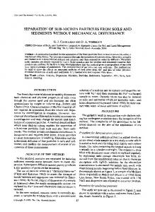
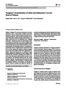
MATERIALS AND METHODS In this three-part study, we analyzed the quantity and composition of summer hillslope runoff as influenced by (i) slope position, (ii) cover type, and (iii) rainfall characteristics. We collected data in three small watersheds above long-term runoff agricultural fields on the Zuni Indian Reservation, New Mexico, in the southeastern part of the Colorado Plateau physiographic province (Fig. 1). The reservation lies at 1800- to 2400-m elevation and receives an average of 300 mm of precipitation annually, much of which often comes during thunderstorms in July, August, and September (Fig. 2). In Zuni runoff agriculture, farmers rely on deep soils on alluvial fans to store winter precipitation SSSAJ: Volume 71: Number 2 • March–April 2007
(typically snow and low-intensity rainfall) for early crop growth and on summer precipitation for crop maturity and grain production. The Sanchez watershed covers 68 ha, the Laate watershed 7 ha, and the Weekoty watershed 125 ha. Each of the watersheds lies in the eastern half of the Zuni Reservation at about 2070-m elevation (Fig. 3). Distribution of soils and vegetation corresponds to slope positions (described by Norton et al., 2003). Broad, level summit and shoulder positions, with 0 to 20% slopes, have shallow, sandy Entisols covered by open pinyon(Pinus edulis Engelm.)–juniper (Juniperus spp.)–oak (Quercus gambelii Nutt.) woodlands with appreciable ponderosa pine (Pinus ponderosa P. & C. Lawson), shrubs such as wavy-leaf oak [Quercus × pauciloba Rydb. (pro sp.) (gambelii × turbinella)], mountain mahogany (Cercocarpus montanus Raf.), fragrant ash (Fraxinus cuspidata Torr.), and antelope bitterbrush [Purshia tridentata (Pursh) DC.] and Douglas-fir [Pseudotsuga menziesii (Mirbel) Franco] in protected areas. Microbiotic crusts and native grasses (e.g., Stipa spp., blue grama [Bouteloua gracilis (Willd. ex Kunthi) Lag. ex Griffiths], squirreltail (Elymus elymoides [Raf.] Fig. 1. Study area location and physiographic provinces of the Southwest. Swezey ssp. elymoides), and mutton grass [Poa fendleriana (Steud.) Vasey]) cover open areas stored for solute analysis. Rainfall was recorded from rain gauges at each on summit and shoulder positions. runoff plot and at a tipping bucket rain gauge equipped with a CRX-20 Backslopes, with 20 to 70% slopes, and FS, with 2 to 25% slopes, data logger (Campbell Scientific Equipment, Logan, UT) located in the are covered by more dense pinyon–juniper–oak vegetation with very Weekoty watershed. little ground cover or microbiotic crusts in interspaces. Backslope Runoff and Sediment by Soil Cover Type soils formed in loamy colluvium over siltstone residuum and grade from shallow Entisols on upper BS to deep, well-developed Alfisols We installed 12 1-m2 bounded plots (2 by 0.5 m) with sediment on FS. Toeslopes, with 0 to 10% slopes, are covered by big sagebrush traps, two plots in each of six cover types, at the Weekoty site (bare (Artemisia tridentata Nutt.), western wheatgrass [Pascopyrum smithii soil, grass, pinyon pine, juniper, oak, and microbiotic soil crust; see (Rydb.) A. Löve], and blue grama with components of rabbitbrush Fig. 3 for approximate locations). Plots were selected to represent pure [Chrysothamnus nauseosus (Pallas ex Pursh) Britt] and weedy herbastands of each prevalent cover type as determined in Norton et al. ceous vegetation in wash areas. (2003). Ground beneath the trees was covered by litter of that species without appreciable amounts of other vegetation, which is typical for Runoff and Sediment by Slope Position this semiarid pinyon–juniper woodland. The plots were located on FS We collected and analyzed summer storm runoff (approximately 1 May to 31 August) from 14 sediment traps below 20-m2 bounded plots (2.5 by 8 m) (Williams and Buckhouse, 1991; Gellis, 1998) at the three study sites (four mesa top, six BS, and four FS plots; see Fig. 3 and Table 1). Data were collected from plots at the Sanchez site (two BS and two FS plots), the Laate site (two SU and two BS plots), and the Weekoty site (two SU plots) during the summer of 1996 and from the Weekoty site (two SU, two BS, and two FS plots) during the summers of 1997 and 1998 (Table 1). Yield–landscape position relationships were consistent among the sites and data-collection periods. The plots were installed at locations with vegetation and soils representative of each slope position. Samples were captured in 19-L buckets from which 4-L, thoroughly mixed subsamples were collected after each runoff event. The depth of runoff trapped in collection buckets was measured for calculation of runoff volume by event. Subsamples were allowed to settle in refrigerators at 4°C and then decanted. Sediment samples were air dried and stored for lab analyses. The superFig. 2. Long-term average monthly precipitation (1949–2005) for Zuni, NM (from the Western Regional Climate Center (2006). natant was preserved with a dilute solution of phenylmercuric acetate and SSSAJ: Volume 71: Number 2• March–April 2007
477
Fig. 3. Topography, slope positions, and runoff plot locations within the three watershed study sites on the Zuni Indian Reservation (modified from Norton et al., 2003).
with 7 to 12% slopes. The sediment traps were monitored during the summers of 1997 and 1998. Sediments and runoff were measured and treated the same as for the 20-m2 slope position plots. All sediment samples were oven dried at 105°C. Particle-size distribution was determined using the sieve and pipette method (Gee and Bauder, 1986). Total C and N concentrations were determined using a Fissions EA1100 dry combustion CNSHO analyzer (Fissions Instruments, Milano, Italy). Inorganic C was determined by coulombmeter in a subset of samples and found to be insignificant relative to total C values. Total P concentrations were determined by alkaline oxidation (Dick and Tabatabai, 1977). Available-P concentrations were measured by the Olsen extraction method (Olsen and Sommers, 1982). Runoff samples were analyzed for cation concentration by
atomic absorption spectrophotometry and anion concentration with a Technicon AutoAnalyzer (Technicon, Tarrytown, NY).
Data Analysis
The yield and composition of runoff water and sediments were analyzed by slope position, cover type, and several rainfall parameters. Also, yields were estimated for whole watersheds. For analyses by slope position and cover type, we analyzed runoff and sediment data by average summer (May–August) yield and average concentration during the study period. For runoff and sediment yield, the experimental unit averaged for analysis of means (basis for n) was the total amount of a given constituent collected during each summer at each runoff plot. This amounted to a total of eight plot-years at the SU, eight at the BS, and six at the FS slope position runoff plots (see Table 1) and four plot-years Table 1. Number of runoff plots monitored at each study site, growing season, and at each cover-type runoff plot. Although we also analyzed yields by event, only results for total summer slope position†. yields of each constituent are presented here because 1996 1997 1998 TOTAL‡ Watershed they represent gross movement of materials toward SU BS FS SU BS FS SU BS FS SU BS FS agricultural fields. Sanchez – 2 2 – – – – – – 2 2 Concentration was analyzed by runoff event. Laate 2 2 – – – – – – – 2 2 The experimental unit averaged for analysis of means Weekoty 2 – – 2 2 2 2 2 2 6 4 4 (basis for n) was the concentration of a given constitu4 4 2 2 2 2 2 2 2 8 8 6 Total yr−1 ent collected after each runoff event that yielded sedi† SU = summit; BS = backslope; FS = footslope. ment at each plot during the entire study period. This ‡ Total by slope position is the basis for n in Table 4. amounted to 34 events at the SU, 39 at the BS, and 478
SSSAJ: Volume 71: Number 2 • March–April 2007
Table 2. Approximate1997 and 1998 summer precipitation at the Weekoty study site. Month
May June July August Total
Long-term average 1997
1997 percentage of average
——— mm ——— 12 31 8.9 52 53 39 60 67 133 189
% 263 582 75 113 142
1998†
1998 percentage of average
mm 1.7 0.2 148 19 169
% 14 2 281 32 127
† 1998 data collected only through 19 August.
31 at the FS runoff plots. At the cover-type runoff plots, bare soil plots yielded runoff 27 times during the two summers, microbiotic crust 30 times, oak cover 26 times, juniper cover 25 times, pinyon cover 22 times, and grass cover 24 times. Means were compared by calculating least significant differences with the GLM procedure (SAS Institute, Cary, NC). To ensure normal distribution and equivalent variance, particle-size distribution data (presented as percentages) were arcsine transformed before statistical analyses. We examined sediment yield and composition from hillslopes in the Weekoty watershed as functions of several characteristics of rainfall measured at the tipping-bucket rain gauge. Maximum rainfall intensity, rainfall duration, duration of maximum intensity, time from start of event until maximum intensity, and length of rainless period before start of event (Ferreira, 1990) were calculated for each event based on a 15-min gap to distinguish events. Each parameter was correlated against runoff and sediment properties from 1997 and 1998 at the Weekoty watershed by regression analysis (trend line function in Microsoft Excel). Total sediment yield from each event is presented here as a surrogate for rainfall parameters because it integrates the many variables that affect relationships between rainfall and runoff and reveals relationships between sediment composition and storm intensity. To estimate yields of runoff, sediment, and selected constituents by whole watershed, we extrapolated the runoff and sediment data from slope position and cover-type plots to the whole watersheds by integrating with spatial distribution data presented in Norton et al. (2003).
RESULTS AND DISCUSSION Rainfall
Fig. 4. Distribution of summer (April–September) daily precipitation, 1896 to 1985, Zuni Pueblo (as compiled by Balling and Wells, 1990).
non-runoff-generating events (Fig. 4). Syed et al. (2003), working at the USDA Walnut Gulch Experimental Watershed near Tombstone, AZ, found that storms yielding low amounts of rainfall were much more frequent than high-yielding events. They also emphasized the importance of the storm core (defined as the portion of the storm having intensities >25 mm h−1) in generating runoff, which is relatively small in areal extent and therefore less likely to occur on smaller watersheds (Syed et al., 2003). Once a storm core reaches a watershed, however, the smaller the watershed the more likely it will generate runoff (Goodrich et al., 1997).
Slope Position Both yield and composition of sediment varied significantly by slope position (Tables 4 and 5), but yield and composition of runoff water did not (Norton, 2000). Included in the analyses are 104 samples from 28 summer storms at the 20-m2 slope position plots. Runoff coefficients (millimeters runoff/millimeters precipitation × 100) averaged 3.8% for all the plot-years combined and ranged from 1.4 to 8.1% This compares favorably to nine hydrologic studies in pinyon–juniper environments reviewed by Wilcox (1994), in which runoff ranged from 1 to 23% of total precipitation, with all but one being 8% or less. Runoff coefficients for large storms in the U.S. Southwest are generally about 25% (Kirkby, 1978). Our values concur with our rainfall intensity data to show that there were no exceptionally intense storms during the study period. Backslopes yielded more than twice as much sediment as SU and FS (Table 4). Backslopes also yielded the most C, N, and P in sediments, but concentrations of these soil organic matter (SOM)
Total summer precipitation was above average in both 1997 and 1998 (Table 2) (the weather station was not installed during 1996). Rain events that generated little or no runoff were far more frequent than larger, stream-flow-generating events, and provided the majority of precipitation (Table 3). Comparison with long-term intensity–duration–frequency curves for the Southwest (U.S. Weather Bureau, 1955) Table 3. Total rainfall and yield and mean C/N ratio for sediment and organic material components in four peak rainfall–intensity categories†. shows that there were no exceptionally intense storms during our study period. Peak Total Available Mean Sediment Total N Total C Total P n‡ Rainfall came as two types of events: on intensity rainfall P C/N fringes of convection thunderstorms or −1 −2 −2 mm mm h ————— mg m —————— gm as frontal systems (Tuan et al., 1973). 0–20 193 158 20.2 36.9 533 6.1 0.27 14.6 a§ Reid et al. (1999) noted a similar dichot- 21–40 38 113 388.5 431.3 7495 63.7 3.05 16.2 ab 9 68 89.0 119.0 2166 22.0 0.77 17.6 bc omy of rainfall events in a study at Los 41–60 6 22 223.5 217.6 3813 43.2 1.21 18.1 c Alamos National Laboratory, about 250 >60 km northeast of Zuni. Long-term daily † Sums and mean C/N ratio from all six runoff plots in Weekoty watershed, 1997 and 1998 summer seasons. precipitation data from Zuni (Balling ‡ n = total number of rainfall events recorded at the tipping bucket rain gauge. and Wells, 1990) shows that nearly 90% § Numbers within each column are significantly different (P = 0.05) from those followed by different letters (LSD test). of annual precipitation comes as minor, SSSAJ: Volume 71: Number 2• March–April 2007
479
Table 4. Mean summer runoff and sediment yield by slope position, 1996 to 1998, based on averages of sums from each plot for each field season†. Slope position‡ n§
Runoff Sediment Sand L
m−2
g
m−2
Silt
Clay
Total C
–––––%––––––
Total N
————— mg
Total P
Avail. P C/N¶
C/P¶
Avg. P/TP
m−2—————
SU
8
1.9 a#
44 a
66 b
21 a
13 a
890 a
49.6 a
12.4 a
0.44 a
15 a
95 b
0.04 b
BS
8
2.8 a
125 b
45 a
30 b
25 b
2150 b
116.2 b
34.2 b
0.77 a
15 a
53 a
0.02 a
FS
6
2.3 a
57 a
58 b
27 ab 16 ab
73.9 ab 18.7 a
0.55 a
12 a
64 a
0.03 a
1200 ab
† Yields represent minimum yields from each slope position; at least one runoff event per year was missed at each trap. ‡ SU = summit; BS = backslope; FS = footslope. § n = total plot-years monitored in each slope position (see Table 1). ¶ C/N and C/P values represent means of individual C/N and C/P in samples where both C and N concentrations or C and P concentrations were available. # Numbers within each column are significantly different (P = 0.05) from those followed by different letters (LSD test).
constituents in BS sediments were equivalent to or less than SU and FS sediments (Table 5). This may be a result of relatively erosive flows due to steeper slopes, finer textured soils, and lack of ground cover (see Fig. 3), which remove proportionally more mineral soil materials from BS, while relatively gentle flows on the other two positions, particularly summits, move proportionally more lowdensity, relatively undecomposed surface litter organic material (OM) fragments. These data support the work of Norton et al. (2003): stable soil microbial environments on SU positions, disturbance-driven erosional environments on BS, and depositional environments on FS. The relatively high erosion rates on BS may contribute to mineralizing soil microbial environments with higher concentrations of mineral C, N, and P in SOM and also to deposition of mineralizing OM on FS, although we did not measure the movement of such materials among the slope positions. Conversely, summit positions are relatively stable with respect to erosion, which probably contributes to relatively stable organic matter dynamics, as described by Norton et al. (2003), where efficient nutrient cycling in an immobilizing soil microbial environment leads to low concentrations of mineral C, N, and P in SOM.
Cover Type Cover type impacted both yield and composition of sediment washed from the 1-m2 plots (Tables 6 and 7), but not that of runoff water. Included in the analyses are 154 sediment and runoff samples collected from the 1-m2 soil cover plots during the summers of 1997 and 1998. Both bare soil and microbiotic crust cover yielded significantly more sediment than pinyon and grass plots (Table 6). Oak and juniper plots yielded intermediate amounts of sediment. Sediment texture followed much the same trend as yield, with the
highest yielding cover types generally having the coarsest sediments. Except for oak plots, yields of C, N, and P in sediments depended largely on overall sediment yield. Sediments from oak cover were very rich in SOM, as indicated by very high yields of C and N. Based on sediment yield, microbiotic crust sediments had lower C/ N and C/P ratios than those from other cover types, possibly due to decomposing algae and lichen from crusts in the sediments. Concentrations (Table 7) of both organic C and total N in sediments from the oak plots were significantly higher than other cover types. Microbiotic soil crust sediments had significantly lower C, N, and P concentrations than all the cover types except bare soil. Yields of sediment and runoff were considerably higher from the 1-m2 cover plots than from the 20-m2 slope position plots for the same rain events. This discrepancy may be due to a scale effect (Wilcox et al., 2003) in which longer slope lengths in the larger plots create transmission losses during the frequent small rainfall events.
Rainfall–Sediment Interactions Most rain at the Weekoty watershed in the 1997 and 1998 field seasons fell in low-intensity events (