Knapp et al.: Shrub Seed Banks in Mixed Conifer Forests Page 32
Fire Ecology Volume 8, Issue 1, 2012 doi: 10.4996/fireecology.0801032 Research Article
Shrub seed banks in mixed conifer forests of northern California and the role of fire in regulating abundance Eric E. Knapp1*, C. Phillip Weatherspoon1, and Carl N. Skinner1 1
USDA Forest Service, Pacific Southwest Research Station, 3644 Avtech Parkway, Redding, California 96002, USA
*Corresponding author: Tel.: 001-530-226-2555; e-mail:
[email protected] ABSTRACT Understory shrubs play important ecological roles in forests of the western US, but they can also impede early tree growth and lead to fire hazard concerns when very dense. Some of the more common genera (Ceanothus, Arctostaphylos, and Prunus) persist for long periods in the seed bank, even in areas where plants have been shaded out. To determine shrub seed density and investigate the feasibility of managing shrub abundance by regulating the size of the soil seed bank with fire, we sampled the seed bank in 24 mixed conifer forest stands throughout northern California. Twenty stands were unburned, two had recently burned in wildfires, and two (McCloud and Jennie Springs) were subjected to experimental prescribed fires with unburned controls. Seeds were extracted from duff and soil that was collected in six layers, to a depth of 10 cm in the mineral soil. Ceanothus seeds were the most abundant (mean = 246 seeds m-2), noted at all sites and at 88 % of sampling locations within unburned sites. Arctostaphylos and Prunus seeds were less abundant (mean = 29 seeds m-2 and 6 seeds m-2, respectively), but still recorded at 64 % and 45 % of the unburned sites, respectively. The depth of seed burial varied at all unburned sites, but some seed was present even at the deepest (6 cm to 10 cm) soil layer, where seed mortality due to heat from burning is least likely. Seed density was substantially reduced, but not eliminated, by October prescribed burns at both McCloud and Jennie Springs, while seed density following July burns at Jennie Springs did not differ from the control. The abundance of buried seed indicates that restoring shrubs to forest understory should be possible even in areas where they are currently lacking. If preventing shrubs from colonizing a site is the management goal, the effectiveness of a single prescribed fire may be limited. Keywords: Arctostaphylos, California, Ceanothus, fire, mixed conifer forest, prescribed fire, Prunus, seed bank Citation: Knapp, E.E., C.P. Weatherspoon, and C.N. Skinner. 2012. Shrub seed banks in mixed conifer forests of northern California and the role of fire in regulating abundance. Fire Ecology 8(1): 32-48. doi: 10:4996/fireecology.0801032. INTRODUCTION Shrubs play a vital ecological role in mixed conifer forests of the western United States by
providing cover and forage for wildlife (Sampson and Jesperson 1963, Conard et al. 1985), fixing nitrogen and improving soil fertility (Conard et al. 1985, Busse et al. 1996), and
Fire Ecology Volume 8, Issue 1, 2012 doi: 10.4996/fireecology.0801032
providing beneficial microenvironments for tree seedling establishment (Dunning 1923, Tappeiner and Helms 1971, Gratkowski 1974). Historically, shrubs were a common yet often patchy component of the forest understory. For example, in 1929, Hasel et al. (1934) found tall shrubs including ceanothus (Ceanothus sp.) and manzanita (Arctostaphylos sp.) to cover 22 % of the forest floor of an old-growth mixed conifer forest in the central Sierra Nevada. The scattered distribution of shrubs within forests was apparently due to both the high light requirements of many shrub species (Cronemiller 1959, Conard et al. 1985), and the heterogeneity of the canopy, with many small gaps occurring amongst tree groups of varying age and density (Show and Kotok 1924). Fires burning every 5 yr to 30 yr (Skinner and Taylor 2006, van Wagtendonk and Fites-Kaufman 2006) likely helped to produce and maintain this structural complexity. In the absence of fire, conifers have invaded the gaps, overtopping and replacing the shrubs in many areas (Gruell 2001, Nagel and Taylor 2005). Large numbers of shrub seeds have been found in the soil, even where living mature plants have long been shaded out (Quick 1956). Such seed may be able to persist for hundreds of years in the seed bank (Gratkowski 1962). When overstory trees are harvested or killed by high severity wildfire, extensive shrub fields often result (Fowells and Schubert 1951, Gratkowski 1974). Competition with dense shrubs has been shown to slow the initial growth of tree seedlings (Conard and Radosevich 1982, Lanini and Radosevich 1986, Oliver 1990, Stuart et al. 1993, McDonald and Fiddler 2001). Shrub patches may also burn at higher intensity than fuels in surrounding forest vegetation (Skinner and Taylor 2006), at least under low live fuel moisture conditions. Shrubs of mixed conifer forests are well adapted to fire. Germination of Ceanothus has been shown to be stimulated by heat (Quick and Quick 1961, Kauffman and Martin 1991), whereas charate from partially burned wood promoted germination in Arctostaphylos
Knapp et al.: Shrub Seed Banks in Mixed Conifer Forests Page 33
(Keeley 1987). Some species of Prunus also form a seed bank (Marks 1974, Morgan and Neuenschwander 1988, Oakley and Franklin 1998), and while the stimulus for germination in these species is not as well understood, the abundance of bitter cherry (P. emarginata [Douglas ex Hook.] D. Dietr.) seedlings after fire (Morgan and Neuenschwander 1988) suggests that similar mechanisms of establishment may apply. While fire promotes germination, too much heat can also kill seed. Shrub seedlings are therefore often less abundant in areas within fires where the most fuel was consumed (Kilgore and Biswell 1971, Weatherspoon 1988, Moreno and Oechel 1991, Huffman and Moore 2004, Knapp et al. 2007). Whether fire kills seeds or stimulates them to germinate depends on both the intensity of the fire as well as the location of the seed in the seed bank. Seed in the organic fermentation and humus horizons are likely to be killed by fires that consume the duff. Seed in the upper soil layers may also be subjected to excessive heating if a large amount of overlying fuel is consumed, especially if the soil is dry (Frandsen and Ryan 1986, Busse et al. 2005, Busse et al. 2010). Shrubs have been the focus of management in cases where there are both too few and too many. Whether fire is effective for increasing the cover of shrubs in areas where they are currently lacking will depend, in part, on the presence of seed in the soil. Conversely, the presence of seed in the soil can hamper the long-term effectiveness of some methods of controlling shrub abundance, such as mastication, hand cutting, or herbicides. Managing shrubs by manipulating the size of the seed bank with fire has also been suggested (Biswell et al. 1955, Weatherspoon 1988). Whether using fire is a viable strategy to manage shrub abundance in forests will depend on improved understanding of seed bank size, depth of seed burial, and how both are affected by fire under varying burning conditions.
Fire Ecology Volume 8, Issue 1, 2012 doi: 10.4996/fireecology.0801032
Knapp et al.: Shrub Seed Banks in Mixed Conifer Forests Page 34
Our study objectives were to 1) quantify the size of the shrub seed bank in mature mixed conifer forest stands; 2) determine where in the duff and upper mineral soil layers shrub seed is most likely to be found; 3) evaluate whether size of the seed bank or location of seeds within the seed bank could be predicted by stand age, stand structure, or site topographic variables; and 4) investigate the effect of prescribed fire and wildfire on the abundance of seed that is located at different depths in the seed bank. METHODS Field Data Collection
We chose second growth as well as unlogged stands in mixed conifer forests in northern California, at elevations between 915 m and 1890 m, to sample (Figure 1, Table 1, Appendix 1). The majority of stands were located on medium to high productivity lands adjacent to recently harvested or burned areas, where shrubs had become an important component of the understory after the disturbance. All of the sampled stands were either slated for harvest or sufficiently mature to harvest (i.e., average trees were conifers >25 cm diameter). At most sites, we sampled the seed bank at 10 points within the stand in either 1987 or 1988. Time limitations resulted in only five sample points at the Mt. Hope location. Sampling points were located 30 m apart along a transect oriented in a random direction, with no sampling point less than 10 m from the edge of the stand. If the edge of the stand was reached, we placed the subsequent sampling point at a 90 degree angle in the direction away from the stand edge. We collected three duff and soil subsamples per collection point, each 1 m from the center in random directions, which we then composited. Each duff and soil subsample was collected from within a 20.9 cm × 20.9 cm metal frame that we placed onto the forest floor sur-
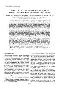
Figure 1. Location of shrub seed bank sampling sites, with site number from Table 1. Prescribed burning experiments were conducted at the McCloud (#1) and Jennie Springs (#7) sites.
face after first removing and discarding litter and small woody fuels. We used a knife to cut the duff (consisting of fermentation and humus layers) and soil vertically along the outer edge. After excavating one side of the square to expose the duff and soil, we extracted six successive forest floor and soil layers within the sampling frame with the help of a spatula and trowel. Each layer was bagged separately. The first layer was of variable thickness, containing all duff located 2 cm or more above the mineral soil boundary, and the second layer was the lower duff from 2 cm down to mineral soil. Layer three was the first 2 cm of mineral soil, layer four went from 2 cm to 4 cm into the soil, layer five went from 4 cm to 6 cm into the soil, and layer six went from 6 cm to 10 cm into the soil.
Fire Ecology Volume 8, Issue 1, 2012 doi: 10.4996/fireecology.0801032
Knapp et al.: Shrub Seed Banks in Mixed Conifer Forests Page 35
Table 1. Sites in northern California at which the shrub seed bank was sampled, arranged from north to south, listing land ownership, date of most recent fire (wildfire or prescribed burn), date sampled, and topographic attributes. Most sites had no record of fire (dashes indicate no record, or were last burned >15 yr ago). Each sample consisted of three composited subsamples, except at the McCloud site where only one collection was made per sample. At the McCloud site, half of the samples were collected from adjacent unburned areas. At the Jennie Springs site, six of the samples were collected from unburned patches within the burn units. NF= National Forest; BLM = Bureau of Land Management. Site No. Site name 1 McCloud 2 Horse 3 Big Poison 4 Underground 5 Flower 6 Hatchet 7 Jennie Springs 8 Rush 9 Soda 10 Galen 11 Brush 12 Bald 13 Mt. Hope 14 Hamburger 15 Bridger 16 Pendola 17 Cummings 18 Sleighville1 19 Sleighville2 20 Washington 21 White Cloud 22 Five Mile 23 Pilliken 24 Dennis Spring
Last Land ownership burned Shasta-Trinity NF Oct 88 Shasta-Trinity NF Lassen NF Shasta-Trinity NF Shasta-Trinity NF Ukiah District BLM Lassen NF Jul, Oct 83 Lassen NF Lassen NF Plumas NF Plumas NF Plumas NF Plumas NF Plumas NF Tahoe NF Tahoe NF Plumas NF Tahoe NF Mar 88 Tahoe NF Tahoe NF Tahoe NF Tahoe NF Eldorado NF Aug 73 Eldorado NF -
At each sampling point, we recorded the elevation, topographic position (ridge top, upper third, mid-slope, lower third), aspect, and percent slope. We estimated basal area by tree species in the surrounding stand with a 20-factor prism. We visually estimated height, density, and cover of woody understory species within a 2 m radius circular plot around each sampling point. To estimate the age of the stand, we either collected increment cores from the largest dominant or co-dominant trees at each site, or we counted rings on stumps in adjacent cut-over areas. Two sites had previ-
Date Samples Aspect Slope Elevation sampled (n) (degree) (%) (m) 1 Nov 88 56 270 2 1150 10 Aug 88 10 82 5 1410 12 Jul 88 10 141 14 1210 21 Jul 87 10 268 21 1282 2 Aug 82 10 52 18 1380 4 Aug 88 10 313 3 1545 Sep 87 19 135