Temporal and Spatial Dynamics of Pre-Euro-American Fire at a Watershed Scale - Caprio, Misc. Pub. No. 2, Assoc. For Fire Ecology, 2004.
Temporal and Spatial Dynamics of Pre-Euro-American Fire at a Watershed Scale, Sequoia and Kings Canyon National Parks1 Anthony C. Caprio ABSTRACT Our understanding of fire as a process in the complex landscapes of the southern Sierra Nevada prior to Euro-American settlement is poor relative to contemporary ecosystem processes. Information primarily consists of fire return intervals from a relatively small number of sites that does not adequately represent past dynamics of fire at a watershed scale. To obtain a better landscape perspective on fire history I used a network of sites located throughout the coniferous zone in the East Fork watershed of the Kaweah River drainage and reconstructed fire regime attributes such as area burned annually and frequency patterns relating to aspect, vegetation type, and elevation. Initial analysis suggested striking differences in the fire regime between north and south aspects with differences strongest at mid-elevations. Fire return intervals on north aspects were less than half that observed on south aspects. Estimates of annual area burned, derived from Thiesson polygons, also showed considerable variability. During certain years fire extended throughout much of the drainage and in a some cases adjacent watersheds also. Pattern and variability in annual area burned were strongly influenced by aspect and annual climate variation. They underscored the importance of climate and topography as controllers of spatial and temporal patterns of fire occurrence. The patterns also suggested strong linkages between fire and ecosystem dynamics with important implications for resource managers restoring fire in the southern Sierra. INTRODUCTION Historically, fire played a key role in the dynamics of most Sierra Nevada ecosystems (Kilgore 1973), shaping ecosystems temporally and spatially. In much of the mixed-conifer zone, fires were primarily non-stand replacing surface fires (Kilgore and Taylor 1979; Warner 1980; Pitcher 1987; Caprio and Swetnam 1995), although exceptions exist (Caprio et al. 1994). The ignition source of fire prior to EuroAmerican settlement is usually attributed to lightning or Native Americans. Beginning with EuroAmerican settlement between 1850-1870, fire regimes in the Sierra Nevada changed dramatically, with sharp declines in fire return intervals in most plant communities (Kilgore and Taylor 1979; Warner 1980; Swetnam et al. 1992; Caprio and Swetnam 1995). Factors contributing to the initial decline include the loss of anthropogenic ignitions and heavy livestock grazing following Euro-American settlement that reduced herbaceous fuels, particularly at lower elevations, and effectively limited fire spread (Caprio and Swetnam 1995). Active fire suppression efforts, begun in the early twentieth century, further decreased or eliminated surface fire as an ecological influence in most Sierran ecosystems. This change in the fire regime led to unprecedented fuel accumulation, structural and composition changes, and resulted in an increased probability of widespread severe fires in many plant communities (Kilgore 1973).
1
Paper presented at 1999 Conference on Fire Management: Emerging Policies and New Paradigms. Nov. 16-19, 1999, San Diego, CA., Sugihara, N., M. Morales, T. Morales (eds), 2004. Misc. Pub. No. 2, Association for Fire Ecology. A. C. Caprio is Fire Ecologist and Fire Research Coordinator, Science and Natural Resources Management Division, Sequoia and Kings Canyon National Parks, 47050 Generals Highway, Three Rivers, CA 93271-9651 (
[email protected]).
-1-
Temporal and Spatial Dynamics of Pre-Euro-American Fire at a Watershed Scale - Caprio, Misc. Pub. No. 2, Assoc. For Fire Ecology, 2004.
The National Park Service’s mission mandates that the agency “protect and preserve” natural resources, which includes restoring and maintaining natural ecological processes. Restoring fire as a process is an important component in this mandate. Beginning in the 1960s land managers began to reintroduce fire within Sequoia and Kings Canyon National Parks (Bancroft et al.1985). While the original emphasis was fuel reduction, the ultimate goal is to restore attributes of past fire regimes in park ecosystems. This has led to a need to better understand the character of these regimes, and how they functioned at both local and ecosystem wide scales. Additionally, information about the range of variation in these attributes is important in understanding landscape level ecosystem processes and in designing and implementing ecologically sound fire management objectives. Unfortunately, most attributes of fire regimes prior to Euro-American settlement are poorly documented particularly in areas with a high frequency surface fire regime. The Parks have recently begun to utilize and integrate current knowledge about past fire regimes into a GIS framework to provide information for ecologically sound management and for optimizing burn program planning (Caprio et al. in press; Caprio and Graber 2000; Keifer et al. 2000). Various models used in this GIS analysis are directly or indirectly derived from the fire history data (tree-ring analysis of fire scars) and historic fire records (obtained from mapped fires). Using this information to summarize fire return intervals (FRI) in various vegetation types, an “ecological needs” model was developed to produce a map of “fire return interval departures” (FRID). The model highlights areas that have deviated from their historic fire regime following Euro-American settlement. The FRID model is a dynamic and valuable decision support tool that integrates ecological information used to prioritize areas for initial treatment with prescribed fire, assists with scheduling successive burns, helps provide economic accountability, and evaluates progress towards achieving landscape-level ecological goals (Caprio and Graber 2000). The quality of the FRID output is dependent on the quality of the fire history information used in its calculation. A number of fire history investigations, utilizing fire scar records from trees, have been carried out in or near the Parks over the last three decades (Kilgore and Taylor 1979; Warner 1980; Pitcher 1981, 1987; Swetnam et al. 1992; Swetnam 1993; Caprio et al. 1994; Caprio and Swetnam 1995; Swetnam et al. 1998). They provide important ecological and management information, such as documenting changes in fire frequency resulting from Euro-American settlement, illustrating relationships between fire and forest structure, and showing the interaction of climate and fire. As the breadth of areas and plant communities sampled from throughout the park has expanded, so has our knowledge and understanding about the underlying characteristics and variability of the pre-Euro-American fire regimes. As a result, we are not only becoming more aware of the complex patterns and relationships of past fire regimes but also of the variability in the quality of our knowledge for different vegetation communities and locations within the Parks. Inadequate site replication frequently results in overly simplistic interpretations of past fire regimes at the landscape level. A recent analysis suggests that good quality information is only applicable to about 26% of the Park’s vegetated area (Caprio and Lineback in press). For example, one facet of past regimes that has been poorly studied is the effect of aspect on past fire occurrence and spread patterns although its influence on contemporary fire behavior and spread patterns is well documented (Agee 1993; Pyne et al. 1996). Several fire history investigations from other regions of North America have suggested there may be shifts in FRI by aspect (Allen et al. 1995; Laven et al. 1980; Taylor and Skinner 1998; Quanfa et al. 1999). This study’s objective was to obtain well replicated estimates of FRI to assess intra- and inter-site variation within specific vegetation types and aspects throughout a watershed that could then be projected with some confidence to larger land units to reconstruct fire size estimates. This paper presents
-2-
Temporal and Spatial Dynamics of Pre-Euro-American Fire at a Watershed Scale - Caprio, Misc. Pub. No. 2, Assoc. For Fire Ecology, 2004.
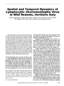
preliminary details about the fire history sampling that has been conducted using a network of sites throughout a watershed with diverse topographic features and vegetation. Results will eventually answer a variety of questions associated with fire regime attributes–such as frequency and size– and how these vary across a landscape by aspect, elevation and vegetation type. STUDY AREA Sampling was conducted in the East Fork drainage (Fig. 1), one of five major drainages comprising the Kaweah River watershed, which historically flowed west into the Tulare Lake Basin in the southern San Joaquin Valley. Terrain is rugged with elevations ranging from 874 m (2,884 ft) to 3,767 m (12,432 ft). The drainage, 21,202 ha (52,369 ac) in size, is bounded by Paradise Ridge to the north, the Great Western Divide to the east, and Salt Creek Ridge to the south. Major topographic features in the watershed include the high elevation Mineral King Valley, Hockett Plateau, the Horse Creek subdrainage, the high peaks of the Great Western Divide, and the Oriole Lake subdrainage. The elevation gradient from the foothills to the higher peaks is exceptionally steep with rapid transitions between vegetation communities. About 80% of the watershed is vegetated with most of the remainder being rock outcrops located on steep slopes and at high elevations. Three broad vegetation zones dominate the watershed: foothills (485 to 1,515 m) composed of annual grasslands, deciduous oak, evergreen woodlands, and chaparral shrubland; conifer forest (1,515 to 3,030 m) with ponderosa pine (Pinus ponderosa Dougl.), lodgepole pine (P. contorta Dougl. var Murrayana Englm.), giant sequoia (Sequoiadendron giganteum [Lindl.] Buchholz), white fir (Abies concolor Lindl. & Gord.) and red fir (A. magnifica Murr.) forests; and the high country (3,030 to 4,392 m) composed of subalpine forests with foxtail pine (P. balfouriana Jeff.), alpine vegetation, and unvegetated landscapes. Vegetation is
Figure 1. East Fork watershed of the Kaweah River drainage showing distribution of sites within the coniferous forest belt (inset shows watershed location within the Parks). Forest vegetation is categorized by elevation (high and low divided at 2286 m) and aspect (N >285° to 285° to