THE ENVIRONMENTAL IMPACTS OF THE INVASIVE PLANT PURPLE LOOSESTRIFE AND ITS HYPERSPECTRAL MONITORING
Guoxiang Liu¹, Jeff Parkey¹, Kang Lu¹ and Jeff Allen¹. Clemson University Gary Kleppel² and David Newman². State University of New York Albany
ABSTRACT
The environmental and ecological problems caused by invasive plants have become too severe to ignore. Purple Loosestrife (Lythrum Salicaria) was introduced from Europe to North America in the 1800s. Now known as the "Purple Plague", it has spread across 48 of 50 states in the US and all provinces in Canada. The U.S. Fish and Wildlife Service declared Purple Loosestrife "Public Enemy #1 on Federal Lands", and The Nature Conservancy listed it as the 2nd most troublesome weed in wetlands (Paul Treitz et al 2001). This invader encroaches on wetland and forage land at a rate of about 190,000 hectares per year, kills off other native plants, reduces biodiversity, creates monocultures in wetlands and turns wildlife habitat into “Biological Desert”. The direct costs are estimated at more than $45 million annually in the United States (John L. Schnase 2002), which has lead to increasing efforts to control Purple Loosestrife. This paper provides a new method for identifying, classifying and mapping the distribution of Purple Loosestrife using hyperspectral remote sensing. The new technique and its resultant information will help effectively monitor and control this invasive species.
KEYWORDS: Invasive Species, Purple Loosestrife, Hyperspectral Remote Sensing, Identify, Classify, Monitor, Mapping ________________________ 1. Spatial Analysis Laboratory, Strom Thurmond Institute, Clemson University, Clemson, SC 29634 Tel. (864) 656-7837; Fax. (864)656-4780 E-mail:
[email protected],
[email protected],
[email protected],
[email protected] 2. Department of Biological Sciences, University at Albany, State University of New York , Albany, NY 12222 Tel. (518) 442-4338; Fax. (518) 442-4767 E-mail:
[email protected],
[email protected] This Paper Was Presented in the 11th International Interdisciplinary Conference on The Environment. June 22-25, 2005, Orlando, FL, USA)
1
INTRODUCTION
Bio-invasion is now considered as a significant component on global change and one of the major causes of species extinction (Drake et al., 1989). Invasive species Purple Loosestrife is an herbaceous wetland perennial that was introduced into North America from Europe in the early 1800s as a garden flower. It is believed that most Purple Loosestrife populations are the result of seeds from garden escapes. Purple Loosestrife destroys native biodiversity by overtaking habitat of native plant species that provide food, shelter, and breeding habitat for wildlife and then establishes its own mono-species kingdom. To help the native species and rescue the wetland habitat, hyperspectral remote sensing provides a way to effectively detect and dynamically monitor Purple Loosestrife, thereby assisting with wetland restoration and management.
THE IMPACTS ON ENVIRONMENT AND ECOLOGY
The “Beautiful killer” Purple Loosestrife is a strikingly beautiful plant. It was introduced into the North America garden trade as "A Plant of Great Beauty". Having long, slender leaves arranged in opposite pairs on a 4-sided square stem, bearing large showy flowers in prominent spikes, Purple Loosestrife is pleasing to the eyes with a distinctive pinky/purple color (Figure 1). It is also a “Beautiful Killer” (Irene Brownstein 1993). The people who first planted it as a showy ornamental probably never thought of this. Its reproductive rate is such that an individual plant can produce more than 2.7 million tiny seeds a year, and even a small piece of stem or root can develop a new plant. A few individual plants can buildup an extensive seed bank that can spread over wide geographic areas by water, by wind, by animal, by vehicle tires or human footwear. Its seeds are also capable of survival in the soil several years before germinating. It invades ponds, beaches, marshes, stream banks, wet farmlands, irrigation and navigation canals, lakeshores, and ditches. Any wetland that receives even one seed may eventually become totally choked out by this weed. It kills off all native plants by blocking solar energy supplying to them when it invaded into an area. Although there are over 120 specieses of insects that prey on Purple Loosestrife regulating population levels in its native Eurasia, the evolved predator/prey relationships was not transferred to North America with the introduction of Purple Loosestrife (Cory Lindgren 1993). Hence, there are no natural predators or diseases of Purple Loosestrife in North America to curtail its spread, no plant can overtake it, nothing hurts it.
2
Figure 1 Purple Loosestrife (Lythrum Salicaria) – The “Beautiful Killer” Photo Courtesy BC Ministry of Forests CA
The “Food Chain Destroyer” Wetlands were healthy and relatively balanced ecosystems in the State of New York before the invasion of Purple Loosestrife. The food chain of the wetland ecosystem was established thousands of years ago and has been stable until recently. Within a typical healthy wetland ecosystem food chain in New York, solar energy goes to the aquatic plants (Common Reed, Sedge, Spike Rush, Marsh Fern, Broadleaf Arrowhead, Spatterdock, Water Horsetail, Pickerelweed, Cattail, Water Hyacinth, Duckweed and Pondweed). Herbivores such as Aphid, Snail, Slug, Grasshopper, Crayfish, Turtle, Grass Carp and Muskrat eat the aquatic plants. The Carnivores prey on Herbivores and some Carnivores prey on some other Carnivores (Cricket eats Aphid; Praying Mantises eats Cricket; Spider eats Praying Mantises; Frog eats Spider and Grasshopper; Waterfowl eats Snail, Crayfish and Sunfish; Catfish eats Frog and Warterfowl; Snake eats Catfish and Young Waterfowl, Owl eats Snake, Snake eats Owl egg and baby Owls). The wildlife specieses in the food chain in New York wetland ecosystem are illustrated in the INDEX by the end of
3
this paper. This food chain or cycle constantly replenishes itself as long as the population of these plants and animals stay in harmony with one another. The food chain of wetland wildlife in New York shows in Figure 2. AQUATIC PLANTS Æ HERBIVORES Common Reed, Sedge, Aphid, Snail, Slug, Marsh Fern, Spike Rush, Broadleaf Arrowhead, Grasshopper, Water Horsetail, Cattail, Crayfish, Spatterdock, Pickerelweed, Turtle, Water Hyacinth, Muskrat Duckweed, Pondweed Grass Carp
Æ
CARNIVORES Cricket, Spider, Praying Mantises, Frog, Sunfish, Marsh Wren, Snowy Plover Dowitcher, Stilt, Limpkin, Catfish, Snake, Owl
Figure 2. The Food Chain of Wetland Ecosystem in New York. This food chain is at risk of being destroyed completely when the Purple Loosestrife invades and begins to replace all of the native plants. Therefore, Purple Loosestrife has also earned its reputation as the “Food Chain Destroyer”. The “Biological Desert Creator” By 1960, more than 1,000 small impoundments had been created in New
4
York State to provide new wetland habitat, particularly for waterfowl (Emerson 1961). Unfortunately, most of these impoundment marshes were occupied by the invasive species Purple Loosestrife during the subsequent decades. The following two pictures provide an excellent illustration of this invasion. The picture showing in Figure 3 was taken at Montezuma National Wildlife Refuge in central New York in 1968. Common Reed, Marsh Fern and Spike Rush colonized the shoreline. Broadleaf Arrowhead, Water Horsetail and Spatterdock emerged from the shallow water. Pondweed, Water Hyacinth and Duckweed floated on the surface. These varieties of aquatic plants provided abundant food for herbivores such as Slug, Grasshopper and Muskrat, in turn these herbivores themselves served as food for carnivores including Praying Mantises, Snake and Owl. The different plant species provided different food and habitat for varied animal communities. There was a harmonious ecological system and a vigorous and healthy plant-animal kingdom there. Figure 4 shows the significant changes that took place over a ten-year period. Purple Loosestrife invaded the area, no native insects, waterfowl or other animals utilize it; no plant can overtake it. It killed off almost all the native plants, destroyed the bio-variety and food chain, and established its own mono-species environment. The herbivores such as Aphid, Grasshopper or Muskrat do not eat Purple Loosestrife. They were forced to move into other place. Those such as Slug and Snail that cannot move into new place are lost. What remains is in essence a “Biological Desert”, devoid of native plants and wild animals. A “Biological Desert” illustrates in Figure 5.
Figure 3. A Typical Biodiversity Environment of Harmonious Ecosystem and a Vigorous Plant-Animal Kingdom at Montezuma National Wildlife Refuge in Central New York. Picture Taken on June 18, 1968. Courtesy of Daniel Q. Thompson 1987.
5
Figure 4. Purple Loosestrife Killed Off Almost All Native Plants and Built Its Own Mono-Species Kingdom Turning the Harmonious Ecosystem into “Biological Desert” Just in 10 Years. Picture Taken in August 1978 in the Same Place. Courtesy of Daniel Q. Thompson 1987.
Figure 5. A “Biological Desert” of Purple Loosestrife. Courtesy Laba, M. 2004
6
AN INNOVATIVE TECHNIQUE FOR IDENTIFICATION, CLASSIFICATION AND MAPPING OF PURPLE LOOSESTRIFE
About Hyperspectral Remote Sensing Any substance has its own characteristics of reflection, absorption and emission of sunlight. These characteristics can be recorded by a camera mounted on an airplane or a satellite. This is aerial or spatial remote sensing. Sunlight can be divided into many different bands such as Ultra Violet, Visible, Near Infrared, Middle Infrared, Thermal Infrared and so on by wavelength, called the solar spectrum. A camera that can record several different bands of reflectance (or absorbance) of solar spectrum is called a multi-spectral camera (scanner). Similarly, a scanner that can record from tens to several hundreds spectral bands is called a hyperspectral scanner or radiometer. Hyperspectral remote sensing uses a hyperspectral radiometer mounted on airplane or satellite to acquire large amounts of spectral information that can be used for identifying, classifying and mapping of a particular object within a huge geographical area. Identification of Purple Loosestrife by Hyperspectra Effective management of Purple Loosestrife requires accurate knowledge of its spatial distribution and density. Early detection and analysis of spatial extent allows local eradication to be carried out with minimum damage to the ecological-environmental system. Some scientists employed remote sensing for mapping of Purple Loosestrife using digital orthophoto quarter-quadrangles and satellite imagery (Laba et al 2004). The accuracy is limited however. Hyperspectral remote sensing offers an enhanced potential for identifying, classification and mapping of this invader. For the wetlands monitoring project in State of New York, a hyperspectral radiometer GER 1500 was used to spectrally identify Purple Loosestrife. This instrument has 520 spectral bands covering from Ultraviolet, Visible and Near Infrared wavelengths. A set of fieldderived hyperspectral profiles of different wetland plants was obtained by employment of this instrument. These hyperspectral profiles were used to establish a unique hyperspectral library of wetland plants named STIHL (Strom Thurmond Institute Hyperspectral Library). Figure 6 Illustrates Purple Loosestrife Identification Spectrum obtained from the wetland in Lower Hudson River in the State of New York.
7
Figure 6. Purple Loosestrife Identification Spectral Plot Field Measurements Taken by: Mr. Donald Van Blaricom Location: Lat. 41°32’35.56” N, Lon. 74°15’25.10” W Date and Time: 11:30 am, 08/13/2003 Spectral Library Created by: Dr. Guoxiang Liu
Finding a Pure Pixel of Purple Loosestrife on the Hyperspectral Imagery Hyperspectral imagery was taken by GER DAIS 3715 (Geographical & Environmental Research Corporation Digital Airborne Imaging Spectrometer) from Orange County of Lower Hudson River in New York on August 22, 2003. It has 37 bands covering Visible, Near Infrared, Middle Infrared and Thermal Infrared wavelengths. The spatial resolution of the hyperspectral photography is 2 X 2 meters². The aircraft type is Chieftain. Figure 7 displays a hyperspectral imagery of flight line 15. A pure pixel (2 X 2 meters²) of Purple Loosestrife was found based on the similarity of spectral profiles extracted from the imagery and from STIHL hyperspectral library. The geographc location derived from GIS techlolegy. A spectral plot extracted from the pixel of imagery shows in Figure 8.
8
Figure 7. Hyperspectral Photography of Flight Line 15 Shows a Pure Pixel (X: 15834 Y: 14270) of Purple Loosestrife Locating at Lat: 38° 47’ 37.63” N, Lon: 76° 13’ 15.48” W Date and Time the Airphoto Was Taken: 2:44~2:47pm, Aug 22, 2003.
9
Figure 8.The Hyperspectral Profile Extracted from the Pure Pixel (X: 15834 Y: 14270) Locating at Lat: 38° 47’ 37.63” N, Lon: 76° 13’ 15.48” W on Hyperspectral Photography Flight Line 15.
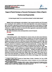
Classification of Hyperspectral Imagery by Spectral Signals A Spectral Angle Mapper (SAM) supervised classification method was employed based on the comparison and matching of the two- hyperspectral signals: one is the Purple Loosestrife identification spectrum comes from STIHL, the other is the spectral profile extracted from the hyperspectral imagery pixel by pixel. Figure 9 displays the result of the classification of Purple Loosestrife. Mapping Purple Loosestrife Distribution Based on the Classification and Ground Thueth Information The classification map indicates the distribution of Purple Loosestrife in the experiment area. The final mapping of Purple Loosestrife distribution was peformed based on the classification results and the ground thueth information derived from the field works. The result of Purple Loosestrife mapping illustrates in Figure 10. The mapping accuracy is great than 90 % according to the field checking and verification.
10
Figure 9. The Classification of Purple Loosestrife Based on the Comparison and Matching of the Identification Hyperspectral Profile with the One Extracted from the Hyperspectral Photography.
CONCLUSION
The invasive plant Purple Loosestrife is a “Beautiful Killer”, a “Food Chain Destroyer” and a “Biological Desert Creator”. It is one of the major causes of species extinction on the Globe. The innovative technique developed in this study uses GER 1500 hyperspectral radiometer and GER DAIS 3715 aerial hyperspectral remote sensing to identify, classify and map Purple Loosestrife. It provides early detection and dynamically monitoring of this invader. The results of classification and mapping indicate that Purple Loosestrife has already invaded a number of areas around the lake and is encroaching on the wetlands. It is recommended that the state and local environmental protection agencies take immediate actions before its spreading gets out of control.
11
Figure 10. The Result of Mapping of Purple Loosestrife Based on Hyperspectral Signal Classification of the Hyperspectral Imagery The Location of the Pure Pixel of Purple Loosestrife: (X: 15834 Y: 14270 Lat: 38° 47’ 37.63” N, Lon: 76° 13’ 15.48” W On Hyperspectral Photography Flight Line 15
12
ACKNOWLEDGMENTS
Support for this study was provided by US Environmental Protection Agency (USEPA) and The New York State Department of Environmental Conservation (NYS DEC). The authors are greatly appreciative of the efforts of the researchers at University at Albany, State University of New York and the researchers at Clemson University, South Carolina, particularly of Mr. Donald Van Blaricom and Mr. Patrick Harris. The GER DAIS 3715 Hyperspectral Photography was provided by SpectroTech, INC.
REFERENCES
Cory Lindgren 1993. The Manitoba Purple Loosestrife Project. http://www.ducks.ca/purple/newsletters/spring93.html Thompson, Daniel Q., Ronald L. Stuckey, Edith B. Thompson. 1987. Spread, Impact, and Control of Purple Loosestrife (Lythrum salicaria) in North American Wetlands. U.S. Fish and Wildlife Service. 55 pages. Jamestown, ND: Northern Prairie Wildlife Research Center Online. http://www.npwrc.usgs.gov/resource/1999/loosstrf/loosstrf.htm (Version 04JUN99). Drake, J.A et al 1989. Biological Invasions: A Global Perspective, SCOPE 37. Wile New York. Emerson, F.B. Jr. 1961. Experiments in the Establishment of Food and Cover Plants in Marshes Created for Wildlife in New York State. New York Fish and Game Journal 8:130-144. Irene Brownstein 1993. Purple Loosestrife—Beautiful Killer. http://perc.ca/PEN/1993-03/brownste.html John L. Schnase 2002. Emerging Science Applications for Geospatial Information. http://dipa.spatial.maine.edu/NG2I03/CD_Contents/EA/Schnase_John_01.pdf John van Dongen 1990 Field Guide to Noxious and Other Selected Weeds of British Columbia, CA Laba, M., S.D. Smith, and M.E. Richmond 2004 Purple Loosestrife Research and Mapping for the Hudson River Valley Study Area, Final Report. New York Cooperative Fish and Wildlife Research Unit, Department of Natural Resources, Cornell University, Ithaca, NY. Northern Prairie Wildlife Research Center 1999 USGS, Spread, Impact, and Control of Purple Loosestrife (Lythrum salicaria) in North American Wetlands History of Control Efforts. Paul Treitz and Dennis Jelinski 2001.Detection and Mapping of Purple Loosestrife in Wetlands of Southeastern Ontario Using CASI and IKONOS Remote Sensing Data. http://larsees.geog.queensu.ca/loosestrife.html
13
INDEX
The Wildlife Specieses in the Food Chain in New York Wetland Ecosystem ( I ) THE AQUATIC PLANTS
. Duckweed (Lemna Minor)
Broadleaf Arrowhead (Sagittaria latifolia)
Marsh Fern (Thelypteris Palustris)
Pickerelweed (Pontederia Cordata)
Spike Rush (Eleocharis Palustris)
Water Hyacinth (Eichhornia Crassipes)
Cattail Common Reed Pondweed Sedge (Typha Litifolia) (Phragmites Australis) (Potamogeton Crispus) (Carex Acutiformis)
14
Spatterdock Water Horsetail (Nuphar Polysepala) (Equisetum Fluviatile) ( II ) THE HERBIVORES
Aphid (Macrosiphum Rosae)
Slug (Arion Ater)
Snail (H. Aspersa)
Redlegged grasshopper (Melanoplus Femurrubrumr)
Grass Carp Crayfish Muskrat Turtle (Ctenopharyngodon Idella) (Bartonii Bartoni) (Ondatra Zibethicus ) (Clemmys Muhlenbergii) ( III ) THE CARNIVORES
Cricket (Nemobius Sylvestris)
15
Praying Mantises (Tenodera Sinensis)
Spider (Argiope Bruennichi)
Pumpkinseed Sunfish (Lepomis Gibbosus)
Black-Neck Stilt (Calidris Mauri)
Catfish (Ictalurus Punctatus)
Barred Owl (Strix Varia)
16
Frog (Rana Clamitans)
Long-Billed Dowitcher (Limnodromus Scolopaceus)
Marsh Wren (Cistothorus Palustris)
Snowy Plover (Charadrius Alexandrinus)
Limpkin (Aramus guarauna)
Rainbow Water Snake (Enhydris Enhydris)