Data Science Journal, Volume 13, 30 October 2014
ANTARCTIC SPACE WEATHER DATA MANAGED BY IPS RADIO AND SPACE SERVICES OF AUSTRALIA K Wang1*, D Neudegg1, C Yuile1, M Terkildsen1, R Marshall1, M Hyde1, G Patterson1, C Thomson1, A Kelly1, and Y Tian1 IPS Radio and Space Services, Bureau of Meteorology, Australia, Level 15, Tower C,300 Elizabeth Street, Surry Hills, NSW, 2010, Australia *Email:
[email protected]
ABSTRACT Ionospheric Prediction Services (IPS) has an extensive collection of data from Antarctic field instruments, the oldest being ionospheric recordings from the 1950s. Its sensor network (IPSNET) spans Australasia and Antarctica collecting information on space weather. In Antarctica, sensors include ionosondes, magnetometers, riometers, and cosmic ray detectors. The (mostly) real-time data from these sensors flow into the IPS World Data Centre at Sydney, where the majority are available online to clients worldwide. When combined with other IPSNET-station data, they provide the basis for Antarctic space weather reports. This paper summarizes the datasets collected from Antarctica and their data management within IPS. Keywords: Antarctic, Space weather, Ionospheric, Magnetometer, Riometer, Data management, AWK, jqPlot
1
INTRODUCTION
Space weather is distinct from the concept of weather within the Earth's atmosphere (troposphere and stratosphere). It is the concept of changing environmental conditions in near-Earth space or the space from the Sun's atmosphere to the Earth's atmosphere. Space weather is the description of changes in the ionosphere, magnetic fields, radiation, and other matter in space. Much of space weather is driven by energy carried through interplanetary space by the solar wind from regions near the surface of the Sun. Since the 1950s, greater than 30 space weather observation stations have been established by various countries, both independently and in collaboration with other countries, operating in the Antarctic region. Many stations are still in daily operation. IPS (Ionospheric Prediction Services) Radio and Space Services of the Australian Bureau of Meteorology is the government entity responsible for monitoring and forecasting space weather. It was established in 1947 with its original name, Ionospheric Prediction Services. The Australian Space Forecast Centre (ASFC), which is also a Regional Warning Centre of space weather for the International Space Environment Service, is the delivery point for many IPS services. Through continuous development over several decades, IPS continues to operate stations within the Australasian region and in Antarctica (Figure 1). There are four Australian stations in the Antarctic and sub-Antarctic operated by the Australian Antarctic Division: Casey, Davis, Mawson, and Macquarie Island (Figure 2). With the addition of the Scott Base ionosonde, operated by the New Zealand Antarctic Programme (NZAP) and the University of Canterbury, IPS collects five different types of space weather related data: ionogram, magnetometer, riometer, cosmic ray, and ionospheric scintillation. The routine data collected flow into the ASFC in near real time (Wilkinson, Neudegg, & Patterson, 2009) and are archived in the World Data Centre (WDC) of IPS. All data are published via the IPS official website (http://www.ips.gov.au/) and File Transfer Protocol (FTP) site (ftp://ftp.ips.gov.au). The data can be downloaded and visualized with online plot tools—specifically, Ptplot (Wang & Yuile, 2013) and jqPlot—after the data file formats are converted into Extensible Markup Language or JavaScript using PHP or AWK. Ionogram data form the main dataset monitored and utilized by IPS. Scaled ionospheric data can be used in High Frequency (HF) communication, predictions, and warnings as well as in global and regional Total Electronic Content mapping. Disturbances or variations in magnetometer, riometer, cosmic ray, and ionospheric
PDA44
Data Science Journal, Volume 13, 30 October 2014 scintillation data are affected predominantly by solar activities, and continual observation of the four datasets collecting these data can be used to help ionospheric monitoring and prediction.
Figure 1. Space weather monitoring stations operated by IPS within the Australasian region and Antarctica (IPSNET)
Figure 2. Positions of five IPSNET space weather monitoring stations in Antarctica
PDA45
Data Science Journal, Volume 13, 30 October 2014
2
IONOGRAM DATA
The ionosphere is a layer of electrons and electrically charged atoms and molecules that surround the Earth, stretching from a height of about 90 km to ~1,000 km. The ionosphere can be divided into D, E, F1, and F2 layers increasing in height above the surface of the Earth. At night, the F layer is the only layer with significant ionization present while the ionization in the E and D layers is extremely low. During the day, the D and E layers become much more heavily ionized, as does the F layer, which develops an additional, weaker region of ionization known as the F1 layer. The F2 layer persists day and night and is the principal reflecting layer for HF communications. The critical frequency of the F2 layer is called foF2. It is the maximum frequency that can be supported by the F2 layer when a wave is vertically incident upon the layer. IPS receives ionosonde data from four Antarctic stations (Macquarie Island, Mawson, Casey, and Scott Base). It measures reflected high-frequency (3–30 MHz) radio signals from layers in the ionosphere. Raw data files from ionosondes are automatically cleaned of radio-frequency interference locally and then transferred to the IPS office in Sydney for further processing, such as regional ionospheric mapping and manual scaling. Raw data files also are saved on digital video/compact discs locally and shipped to the WDC in Sydney during each solar summer. Scaled ionogram data have been used by IPS to study the complicated dynamics of the polar ionosphere (Neudegg, Terkildsen, & Wang, 2012; Neudegg, 2013; Wilkinson, Neudegg, & Patterson, 2009) and to predict the best communication frequency between two locations. Figure 3 is an Air Route Prediction Tool for the Australian Antarctic Programme, which can be used to predict the best usable telecommunication frequency between an aeroplane and a base station in the Antarctic region.
Figure 3. Air Route Prediction Tool for the Australian Antarctic Program (left) and an example result (right) All archived raw and clean ionogram data, 15 different hourly scaled ionospheric parameter data, and two ionospheric median data of foF2 and M(3000)F2 are available at the WDC section of the IPS website (http://www.ips.gov.au/World_Data_Centre), for online plotting with Ptplot (Wang & Yuile, 2013) or jqPlot tools and/or FTP download.
3
MAGNETOMETER DATA
Magnetometers measure variations in the geomagnetic field. Solar flares may produce sudden impacts on the geomagnetic field, known as Solar Flare Effects, due to the increased conductivity of the E layer. Variations of the Earth’s geomagnetic field are also observed during geomagnetic storms resulting from interaction of the geomagnetic field, solar wind, and interplanetary magnetic field. This interaction causes enhancements of the near-Earth current systems, which are measured by ground level magnetometers as rapid fluctuations in the geomagnetic field. Figure 4 is a magnetometer plot of a geomagnetic storm caused by a large solar storm monitored on 29 October 2003 at Casey station. When the magnetic storm occurred, the ionosphere property changed, and the foF2 values observed at some low latitude stations suddenly decreased and completely disappeared at high latitude stations (i.e., Casey, Mawson, and Macquarie Island). At present, there are five operating magnetometers at four Antarctic stations (Casey, Davis, Mawson, and Macquarie Island) out of the 11 total magnetometer stations across IPSNET (Figure 1). To evaluate disturbances of the geomagnetic field, indices such as the K- and AusDst-index have been developed. These indices are used within IPS to issue alerts, warnings, and reports and are employed as parameters in the Auroral Oval Prediction Tool. All magnetometer data are available at the WDC section of the IPS website (http://www.ips.gov.au/World_Data_Centre/1/2) for online plotting with Ptplot (Wang & Yuile, 2013) or jqPlot tools and/or FTP download (ftp://ftp.ips.gov.au/wdc-data/mag/data/).
PDA46
Data Science Journal, Volume 13, 30 October 2014
Figure 4. Magnetometer plot of a magnetic storm caused by a large solar storm monitored on 29 October 2003 at Casey station
4
RIOMETER DATA
A riometer (relative ionospheric opacity meter) is an instrument used to measure the level of ionospheric absorption of electromagnetic (radio) waves in the ionosphere. In the absence of any ionospheric absorption, this radio noise, averaged over a sufficiently long period of time, forms a quiet-day curve (QDC). Increased ionization in the ionosphere will cause absorption of both terrestrial and extraterrestrial radio signals and a departure from the QDC. The difference between the QDC and the riometer signal is an indicator of the amount of absorption and is measured in decibels (dB). Similar to magnetometer data, riometer data are highly affected by solar activity and magnetic storms. For example, on 29 October 2003, along with the occurrence of a solar flare, the riometer absorption value measured at Casey station increased to over 13 dB (Figure 5). IPS has riometers installed at four Antarctic stations: Casey, Davis, Mawson, and Macquarie Island (Figure 2). These riometers are used to measure the absorption of 30-MHz high-frequency galactic radio waves by the lowest D-region of the ionosphere during geomagnetic storm events, which is known as Polar Cap Absorption (PCA). A PCA causes an HF radio blackout for transpolar circuits and can last for several days. PCAs are almost always preceded by a major solar flare, with the time between the flare event and the onset of the PCA ranging from a few minutes to several hours. Consequently, PCAs are one of the important HF propagation conditions that IPS issues online. When absorption exceeds 1 dB, the online warning icon will change from green to red. Riometer data are available at the WDC section of the IPS website (http://www.ips.gov.au/World_Data_Centre/1/8) for online plotting and/or FTP download (ftp://ftp.ips.gov.au/wdc-data/riometer/data/).
5
IONOSPHERIC SCINTILLATION DATA
Ionospheric scintillation is a rapid phase and/or amplitude variation of a radio-frequency signal, generated as the signal passes through an ionosphere region in which the electron density has a small-scale irregularity. It is primarily an equatorial and high-latitude ionospheric phenomenon although it can (and does) occur at lower intensity at all latitudes. Ionospheric scintillation affects trans-ionospheric radio signals up to a few GHz in frequency. It has detrimental impacts on satellite communication and navigation.
PDA47
Data Science Journal, Volume 13, 30 October 2014
Figure 5. Riometer absorption increased with the occurrence of the solar flare on 29 October 2003 An Ionospheric Scintillation Monitor (ISM) is a single or dual-frequency Global Positioning System receiver specifically designed to monitor ionospheric scintillation levels in real time. Macquarie Island is the only Antarctic ISM station out of the six ISM stations across IPSNET (Figure 1). Current ionospheric scintillation conditions are updated every 10 min on the Satellite section of the IPS website (http://www.ips.gov.au/Satellite/1/1; Figure 6). Archived data can be found in the WDC section of the IPS official site (http://www.ips.gov.au/World_Data_Centre/1/11).
Figure 6. Amplitude (left; 30 September 2013) and phase (right; 8 October 2012) scintillation of the ionosphere observed at Macquarie Island station
6
COSMIC RAY DATA
Cosmic rays are formed mainly of protons, which originate from outside the solar system as Galactic Cosmic Radiation. A smaller and much more variable component of cosmic rays arises from the Sun and is termed Solar Cosmic Radiation (SCR). Cosmic ray detectors are operated by the Australian Antarctic Division (AAD) at
PDA48
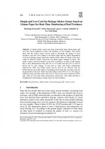
Data Science Journal, Volume 13, 30 October 2014 Mawson, Antarctica and at Kingston, Hobart (Figure 1). These detectors actually monitor neutrons, which result from a cosmic ray particle entering and interacting with the Earth’s atmosphere. Cosmic ray data are applied in space weather forecasting based on two cosmic ray events: Forbush Decrease Events and Ground Level Events (Figure 7). A Forbush Decrease Event happens when a Coronal Mass Ejection (CME) of the Sun causes a reduction in neutron monitors count rate of greater than 3% and typically lasts between several hours and a few days. A small Forbush decrease of cosmic ray intensity indicates a mass CME between the Sun and Earth. A Ground Level Event is an increase in neutron monitors count rate due to the addition of SCR from a solar proton event. These high energy solar protons can penetrate the Earth's magnetic field and cause ionization in the ionosphere. All Cosmic ray data can be found in the WDC section of the IPS official site (http://www.ips.gov.au/World_Data_Centre/1/7).
Figure 7. Cosmic ray data detected at Mawson station, from 04 Universal Time (UT) of the 322nd day of 2013 (18 November 2013) to 04 UT of the 325th day (21 November 2013)
7
CONCLUSION
The Antarctic region is a highly important area for observing, monitoring, and detecting space weather, because energy is focused onto the polar ionosphere by the near-vertical geomagnetic field that maps out the boundary of the Earth’s magnetosphere with the solar wind. Disturbances from the polar region in the ionosphere travel equatorwards and affect the mid-latitude ionosphere. The collected data are irreplaceable in terms of ionospheric mapping, HF forecasting, and other applications of space weather research and forecasting.
8
ACKNOWLEDGEMENTS
We are deeply grateful to our colleagues who have made contributions to Antarctic station establishment and maintenance in the past decades. We are also particularly thankful to AAD, Geoscience Australia, NZAP, The University of Newcastle of Australia, The University of Canterbury of New Zealand, and The International Centre for Space Weather Science and Education of Japan.
9
REFERENCES
Neudegg, D. (2013) Antarctic polar cap ionosphere and effects of solar EUV, magnetosphere-ionosphere coupling and thermospheric transport. Australian Space Science Conference ASSC-13, UNSW, Sydney, Australia.
PDA49
Data Science Journal, Volume 13, 30 October 2014 Neudegg, D., Terkildsen, M., & Wang, M. (2012) Long term median foF2 variations in the Antarctic polar cap and the competing effects of solar EUV, magnetospheric precipitation and ionization transport. 39th COSPAR (ICSU Committee on Space Research) Scientific Assembly 2012, Mysore, India. Wang, K. & Yuile, C. (2013) The application of an online data visualization tool, Ptplot, in the World Data Centre (WDC) for Solar-Terrestrial Science (STS) in IPS Radio and Space Services, Australia. Proceedings of the 1st WDS Conference in Kyoto 2011, Data Science Journal 12, pp WDS101-WDS104. Wilkinson, P., Neudegg, D., & Patterson, G. (2009) Space weather reports for Antarctica during the international polar year. Ionospheric Radio Systems and Techniques, Edinburgh, UK, pp 1–5.
(Article history:Available online 30 September 2014)
PDA50