Journal of Marine Systems 138 (2014) 3–19
Contents lists available at ScienceDirect
Journal of Marine Systems journal homepage: www.elsevier.com/locate/jmarsys
Towards understanding the influence of environmental conditions on demersal resources and ecosystems in the western Mediterranean: Motivations, aims and methods of the IDEADOS project E. Massutí a,⁎, M.P. Olivar b, S. Monserrat c, L. Rueda a, P. Oliver a a b c
Instituto Español de Oceanografía, Centre Oceanogràfic de les Balears, Moll de Ponent s/n, 07015 Palma de Mallorca, Spain Institut de Ciències del Mar (CSIC), Passeig Marítim 37-49, 08003 Barcelona, Spain Departament de Física, Universitat de les Illes Balears,07122 Palma de Mallorca, Spain
a r t i c l e
i n f o
Article history: Received 25 March 2013 Received in revised form 24 January 2014 Accepted 29 January 2014 Available online 5 February 2014 Keywords: Hydrodynamics Zooplankton Mid-water nekton Benthos Species assemblages Trophic coupling Deep scattering layers Demersal resources Population dynamics Catchability Balearic Islands Western Mediterranean
a b s t r a c t The multidisciplinary IDEADOS project funded by the Spanish Government was developed between 2009 and 2012 aiming to determine the relationships between environmental conditions and the nekto-benthic slope communities in two areas of the western Mediterranean, north and south of the Balearic Islands, with different geomorphologic and hydrodynamic characteristics. In this paper we describe the background and goals of this project, its study area and the sampling strategy applied, as well as the main conclusions reached in a final workshop. This volume is a compendium of the main contributions presented at this workshop, which have been peerreviewed and can represent the state of the art of the complex interactions between the pelagic domain and the slope benthic communities, within the context of the hydrodynamics and oligotrophy of the Balearic Islands, and considering different temporal scales and organization levels. © 2014 Elsevier B.V. All rights reserved.
1. Introduction The relationship between environmental factors and the population dynamics of marine resources has been widely recognized in the field of oceanography. Although increased fishing activity has been identified as the main cause of the collapse of some populations (e.g. Cook et al., 1997; Myers et al., 1996; Pauly, 2009), it has been also recognized that environmental variables, both abiotic (climate and hydrography) and biotic (trophic resources and predators), can cause intra- and interannual oscillations in the population dynamics of exploited species (Cushing, 1982; Laevastu and Favorite, 1988). In recent decades, the ecosystem-based approach has established that the conservation of marine living resources must take into account the complexity and functioning of the ecosystems, their natural variations and the factors that control these changes (Browman and Stergiou, 2004; Pikitch ⁎ Corresponding author. Tel.: +34 971133720; fax: +34 971404945. E-mail address:
[email protected] (E. Massutí). 0924-7963/$ – see front matter © 2014 Elsevier B.V. All rights reserved. http://dx.doi.org/10.1016/j.jmarsys.2014.01.013
et al., 2004). To this aim, information on the different ecosystem components is required. Nevertheless, one of the major obstacles for its implementation is, precisely, the lack of sufficient data on the structure and dynamics of ecosystem components, both biotic and abiotic. To resolve this, a multidisciplinary approach is needed (Cury, 2006). In the western Mediterranean basin, important intra- and interannual fluctuations have been described in the distribution, structure and population dynamics of the main nekto-benthic species, which affect their accessibility to fishing exploitation (Astudillo and Caddy, 1986; Caddy, 1993). These changes have been observed both on the exploited shelf (e.g. Levi et al., 2003; Lloret and Lleonart, 2002; Lloret et al., 2000, 2001) and slope areas (e.g. Aguzzi et al., 2003; Maynou and Sardà, 2001; Sardà and Maynou, 1998; Sardà et al., 1997; Tobar and Sardà, 1992). There is general agreement in these studies that such fluctuations are partly due to biotic and abiotic factors. This spatio-temporal variability in oceanographic conditions affecting nekto-benthic species subject to exploitation has also been reported around the Balearic Islands, located at the center of the basin (Fig. 1),
4
E. Massutí et al. / Journal of Marine Systems 138 (2014) 3–19
Fig. 1. Map of the study area, Balearic Islands (western Mediterranean), showing the 200, 600, 800, 1000 and 2000 m isobaths.
influencing both fish and cephalopods from the shelf (Oliver, 1993; Quetglas et al., 1998), and decapods from the slope (Carbonell et al., 1999). In this context, the former IDEA project “Influence of oceanographic structure and dynamics on demersal populations in waters of the Balearic Islands” (http://www.ba.ieo.es/idea/home/home_i.htm), developed between 2003 and 2006, aimed to study the abiotic (oceanographic structure and dynamics) and biotic (trophic resources) factors, which can affect the deep water ecosystems and demersal resources of the Balearic Islands. The project was based on two approaches. The first consisted of the analysis of intra-annual (seasonal) variability through oceanographic surveys, monitoring of the bottom trawl fishing fleet and study of the population dynamics of European hake (Merluccius merluccius) and red shrimp (Aristeus antennatus), two key species of the slope ecosystems of the western Mediterranean, with very different life strategies. The second examined inter-annual variability, by means of joint analysis of population parameters of these species and climatic, meteorological and oceanographic indices, as indicators of environmental conditions in the study area. The IDEA project initiated a multidisciplinary research approach on the dynamics of deep water exploited ecosystems of the Balearic Islands, being one of the first projects integrating an ecosystem approach in the western Mediterranean. Its main results allowed the development of models explaining how climatic conditions in the northwestern Mediterranean influence the hydrodynamics around the Balearic Islands (Monserrat et al., 2008), and the recruitment processes of hake and red shrimp (Massutí et al., 2008). In the case of hake, this vulnerability to environment was found to be induced by the longterm fishery pressure, which reduced the resilience of the population to adverse environmental conditions (Hidalgo et al., 2009, 2011). Distinct hydrodynamic scenarios were found on the traditional fishing grounds north and south of the Archipelago (Lopez-Jurado et al.,
2008), which could be the basis of the differences observed in these two areas with respect to trophic resources (zooplankton and suprabenthos; Cartes et al., 2008a, 2010), nekto-benthic assemblages (Moranta et al., 2008), and the population dynamics, biology, condition and feeding of hake (Cartes et al., 2009; Hidalgo et al., 2008a, 2008b), red shrimp (Cartes et al., 2008b; Guijarro et al., 2008) and other deep water decapods such as Parapenaeus longirostris and species of the genus Plesionika (Guijarro et al., 2009, 2012). In addition, it was observed that environmental factors (modeled by meso- and macroscale climatic indexes) and/or biological factors (spawning population and body condition) can influence the dynamics of hake and red shrimp populations and their accessibility to fishing exploitation (Carbonell et al., 2008; Massutí et al., 2008). From analysis of stable isotopes of hake otoliths, the IDEA project also developed the hypothesis that the reinforcement of the slope fronts flowing southwards and northwards along the continental and insular margins could favor the connectivity between the Iberian Peninsula and the Balearic Islands. These conditions could increase the arrival to insular bottoms of the primary stages and pre-recruits of hake from spawning grounds on the peninsular slope, thus increasing the number of specific recruitment events and their abundance in the Archipelago (Hidalgo et al., 2008b). The MAS project “Analysis of the spatial structure of early life stages of hake, anchovy and sardine in the northwestern Mediterranean. Interaction with hydrography and trophic availability” was carried out between 2004 and 2007 on the Iberian Peninsula coast. The main result of this project showed the preferential location of hake eggs and larvae on the continental shelf margin, highlighting the importance of oceanographic meso-scale phenomena associated with the shelf-slope currents on their distribution (Olivar et al., 2010). The submarine canyons along the north-eastern Iberian Peninsula play a very important role in the transfer of matter from the continental
E. Massutí et al. / Journal of Marine Systems 138 (2014) 3–19 Table 1 Characteristic values of potential temperature (θ; °C) and salinity (S; psu) for the different water types and local values at the Balearic Islands. AW: Atlantic Water; WIW: Western Mediterranean Intermediate Water; LIW: Levantine Intermediate Water; WMDW: Western Mediterranean Deep Water. From López-Jurado et al. (2001). Water mass
Values at origin
Local values
AW
15.0 b θ b 18.0 36.15 b S b 36.50 12.5 b θ b 13.0 37.90 b S b 38.30 14.0 b θ b 15.0 38.70 b S b 38.80 12.7 b θ b 12.9 38.40 b S b 38.48
15.0 b θ b 28.0 36.15 b S b 37.50 12.5 b θ b 13.0 37.90 b S b 38.30 13.0 b θ b 13.4 38.45 b S b 38.60 12.7 b θ b 12.9 38.40 b S b 38.48
WIW LIW WMDW
shelf (mostly river run-off) to the slope (Buscail et al., 1990; Puig et al., 2000), increasing the availability of benthic prey and thus widening the spectrum of deep trophic networks in the western Mediterranean (e.g. Carrassón and Cartes, 2002; Cartes, 1998). These flows and the re-suspension of sediments on the continental margin have been well studied (e.g. Palanques et al., 2005; Puig et al., 2000), but information concerning their possible effects on the deep demersal macro-fauna is scarce. Some authors indicate that they might influence reproduction, recruitment processes and the catchability of decapods (Company et al., 1997, 2003, 2008; Puig et al., 2001). Nevertheless, on the insular slope off the Balearic Islands, these geomorphologic structures practically do not exist (Acosta et al., 2002), and there is not much terrigenousmuddy sediment due to the absence of river discharges. Therefore, the oligotrophic conditions are more severe and the benthos depends more directly on planktonic prey (Maynou and Cartes, 2000). These factors could explain the differences between the deep ecosystems of the peninsular and insular slope, in terms of the communities (Massutí et al., 2004; Maynou and Cartes, 2000; Moranta et al., 1998) and the bathymetric distribution of some species (Cartes et al., 2004). Departing from previous knowledge, the IDEADOS project “Structure and dynamics of the bentho-pelagic slope ecosystem in two oligotrophic zones of the western Mediterranean: a multidisciplinary approach at different spatio-temporal scales in the Balearic Islands” (http://www.ba.ieo.es/ideados/) was designed to carry on the research necessary to test the hypotheses raised by the IDEA project. This project expands the study to: (i) the pelagic domain, on which deep ecosystems of the Balearic Islands seem to depend; and (ii) biotic and abiotic factors,
5
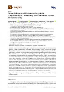
which determine the spatio-temporal heterogeneity in the slope communities and their trophic resources. They also influence the high temporal variability in the population dynamics of key species, such as the red shrimp, which is reflected in its accessibility to fishing exploitation; (iii) the trophic dynamics of the nekto-benthic communities and their coupling with the planktonic domain; and, (iv) the integral modeling of the deep ecosystems. 2. Study area The Balearic Islands are situated on a promontory in the western Mediterranean, separated from the Iberian Peninsula by a distance up to 95 nautical miles and depths between 800 and 1800 m (Fig. 1). The continental shelf can be divided in two, the larger Mallorca–Menorca shelf to the east, narrow on the northern side (3 km width) and wider in the south (up to 35 km width), and the smaller Ibiza–Formentera shelf to the west, from 2 km wide on the eastern side to more than 25 km wide in the west (Acosta et al., 2002). The slope on the western and southern sides is gentle (6º average inclination) in some parts with no clear shelf-break, while the northern and eastern sides have an abrupt slope (16º average inclination), with a clear shelf-break, several seamounts and a pronounced scarp, with depths ranging from 200 to 800 m in its shallowest part to more than 2000 m at its base. The sediments of the shelf are mainly biogenic sands and gravels. Sandy–muddy and detrital bottoms are present at the shelf-slope break, whereas muddy sediments of biogenic origin dominate the deeper areas (Acosta et al., 2002; Canals and Ballesteros, 1997). The archipelago delimits the Balearic sub-basin (BsB) in the north from the Algerian sub-basin (AsB) in the south. These sub-basins are characterized by different oceanographic conditions ( EUROMODEL Group, 1995), and are connected by a series of channels with depths between 100 and 800 m, which play an important role in the regional circulation, as passages for the exchange of water masses between them. The BsB is more influenced by atmospheric forcing and Mediterranean waters, which are colder and more saline, whereas the AsB is affected basically by density gradients and receives warmer and less saline Atlantic waters (Pinot et al., 2002). Different water masses can be found in both sub-basins (Table 1). The surface waters, coming from the Atlantic and called Atlantic Waters (AW), have high seasonal temperature variation, ranging from 13 °C during winter to 26 °C during summer, when a strong vertical temperature gradient is established
Fig. 2. Averaged regional ocean circulation in the western Mediterranean corresponding to late spring–summer after a relatively mild winter, May 1997 (a) and after a relatively cold winter, May 1996 (b). Major currents in the region, the Northern Current (NC) and the Balearic Current (BC) are indicated. AW: Atlantic Water; WIW: Western Mediterranean Intermediate Water; LIW: Levantine Intermediate Water. From Monserrat et al. (2008).
6
E. Massutí et al. / Journal of Marine Systems 138 (2014) 3–19
between 50 and 100 m depth. The Levantine Intermediate Water (LIW), originating in the eastern Mediterranean, reaches the Balearic Islands after circulating through the northern part of the western Mediterranean. It shows maximum temperature and salinity (~ 13.3 °C and ~ 38.5, respectively) and is found at approximately 200–700 m depth, just above the Western Mediterranean Deep Water, (WMDW), which is located in the lowest part of the water column. Finally, the Western
Mediterranean Intermediate Water (WIW) is found at approximately 100–300 m depth, under the surface water and normally above the LIW, and exhibits variable thickness. It is characterized by a minimum temperature (~12.5 ºC). WIW forms during winter in the Gulf of Lions by deep convection only when sea-air heat flux losses are high enough (Mertens and Schott, 1998; Pinot et al., 2002) so these waters do not reach the Balearic channels every year. Despite this general pattern of
Fig. 3. Vertical cross sections of potential temperature (°C, left) and salinity (right) along the Ibiza channel after a relatively mild winter, May 1997 (a, b) and after a relatively cold winter, May 1996 (c, d). From Monserrat et al. (2008), after López-Jurado et al. (2001).
E. Massutí et al. / Journal of Marine Systems 138 (2014) 3–19
water masses, some differences in the hydrographic structure are found between sub-basins, showing the water column underneath the AW with less variation in the AsB than the BsB (Lopez-Jurado et al., 2008). The regional circulation in the study area is dominated by the Northern Current (NC), which carries down waters from the Gulf of Lions along the continental slope of the Iberian Peninsula into the BsB (Font et al., 1998). This current bifurcates when reaching the Ibiza Channel; one significant part crosses the channel transporting waters from the BsB into the AsB, while the other part cyclonically returns to the northeast forming the Balearic Current (BC), along the northern coast of the Balearic Islands. This latter current is also increased by flows of AW passing northwards through Ibiza and Mallorca channels (Fig. 2a). This pattern, which is the one expected for late spring and early summer after a mild winter in the north-western Mediterranean, changes considerably after a cold winter (García Lafuente et al., 1995; Pinot et al., 2002). If significant WIW is generated in the Gulf of Lions during cold winter, these waters, reaching the Balearic channels in the late spring, usually deflect downwards the more saline LIW, which normally occupies these levels when WIW is absent (Fig. 3). The NC may then be blocked when reaching the Ibiza Channel and mostly re-circulates cyclonically joining the BC, without significant transport of waters through this channel (Fig. 2b). This fact produces a clear inter-annual variability of the regional circulation around the Balearic Islands, which is strongly related to the properties and the amount of WIW reaching the channels in late spring (Millot, 1999; Pinot et al., 2002) and consequently to the winter climatic conditions in the Gulf of Lions (Monserrat et al., 2008).
7
Within the general oligotrophic environment of the Mediterranean, the waters around the Balearic Islands show more pronounced oligotrophy than the adjacent waters off the Iberian coast and the Gulf of Lions due to the lack of supply of nutrients from land runoff (Bosc et al., 2004; Estrada, 1996). Frontal meso-scale events between Mediterranean and Atlantic waters (Pinot et al., 1995) and input of cold northern water into the channels (Fernández de Puelles et al., 2004), can act as external fertilization mechanisms that enhance productivity off the Balearic Islands. Trophic web structures show differences between the BsB and AsB: they are supported more by plankton biomass than by benthic productivity in the AsB, while supra-benthos plays a more important role in the BsB (Cartes et al., 2001; Maynou and Cartes, 2000).
3. Hypothesis and objectives In the Balearic Islands, the coupling between the pelagic and benthic domains is relatively more important than in other areas of the western Mediterranean, such as the peninsular coast, in which the continental contributions determine the hydrological and sedimentological dynamics and act as drivers of biological productivity in the deep water ecosystems. In addition, the slope communities in the BsB are more influenced by processes taking place on the continental margin of the Iberian Peninsula and Gulf of Lions, resulting in greater availability of benthic prey in their trophic networks. On the contrary, the AsB pelagic resources play a greater trophic role for benthic species.
Fig. 4. Map showing the stations sampling carried out during the IDEADOS surveys (a: hydrographic sampling with CTD and mooring sites; b: zooplankton sampling; c: acoustics and pelagic trawl; d: bottom trawl and epi-benthic sledge). The ports Sóller, Andratx and Palma, in which bottom trawl fishery monitoring was developed in parallel to these moorings are shown in Fig. 1.
8
E. Massutí et al. / Journal of Marine Systems 138 (2014) 3–19
The IDEADOS project hypothesized that the differences observed between the nekto-benthic communities of these sub-basins could be due to a different trophic structure associated with the different degree of oligotrophy. The differences observed in the structure and population dynamics for some key species of the slope communities, such as hake and red shrimp, can be a good example, probably as a consequence of the particular oceanographic conditions in each zone, which determine the accessibility of these resources to fishing exploitation. The main objective of the IDEADOS project was to determine the relationships between environmental conditions and the nektobenthic slope communities in two areas of the western Mediterranean, with different geomorphologic and hydrodynamic characteristics. We put special emphasis on hake and red shrimp, and on the study of the trophic coupling of the nekto-benthic species and those in the meso-pelagic domain. Different temporal scales and different levels of organization (population, community and ecosystem) were also analyzed. The project approached this study of the pelagic and benthic domains from a multidisciplinary perspective, within the context of the hydrodynamics, at two areas of the BsB and AsB. The specific objectives were: i. To determine the effect of seasonal hydrodynamic variability on the species and communities of the slope and their pelagic trophic resources by studying the micro-, meso- and macro-zooplankton and the micro- and macro-nekton. ii. To determine the viability of applying acoustic methods to characterize the mesopelagic communities in the Deep Scattering Layers (DSL). iii. To determine how high frequency variability (daily, fortnightly and/ or monthly) of oceanographic conditions influences the biology and dynamics of red shrimp, the most abundant species on the seafloor at upper and middle slope depths. iv. To contextualize the oligotrophic ecosystems of the Balearic Islands from a global perspective in the western Mediterranean, based on: (i) estimation of the degree of connectivity between populations of the continental margin of the north-western Mediterranean and the Balearic Islands, using geochemical markers in hake otoliths; and, (ii) analysis of information from fishery exploitation on the peninsular coast and the archipelago.
4. Study strategy and sampling methodologies To carry out these objectives, three approaches were applied: (i) collection of data and samples at sea; (ii) monitoring of fishing exploitation; and (iii) compilation of information from existing databases (e.g. satellite images, other surveys and research projects) and published work. The sampling was developed at two areas western and southern Mallorca, situated in the BsB and AsB, respectively, which include the traditional fishing grounds of the bottom trawl fishery, and called Sóller and Cabrera, respectively (Fig. 4). Although these areas are separated by a short distance (~ 50 nautical miles), they show well differentiated geo-morphological and oceanographic characteristics. Sóller has a gentle slope that reaches up to 1800 m depth and links with the peninsular slope, with hydrodynamics determined by the intra- and inter-annual variability in the cyclonic rotation formed by NC–BC front system (Pinot et al., 2002). Cabrera has a more irregular slope, with a gentle side in the west, down to a maximum depth of 1100 m, and a very pronounced scarp down to a depth of 2600 m on the eastern side (Acosta et al., 2002). In addition, it exhibits less defined hydrodynamics, which is under the influence of gyres that break away from Atlantic waters entering the Mediterranean through the Strait of Gibraltar and flowing eastward along the African continental margin (Millot, 1999). Collection of data and samples in these two areas was carried out with two moorings and two multidisciplinary surveys.
4.1. Moorings and fisheries monitoring From November 2009 to February 2011, one mooring was placed in each study area, over the isobath of 850–900 m(approximately at 39º49.682 N-002º12.778 E in Sóller and 38º59.484 N-002º28.907E in Cabrera; Fig. 4a), in the vicinity of the zones exploited by the bottom trawl fishery, but at greater depths. Each mooring was equipped with four CTDs, two current meters and a sediment trap (Fig. 5). More detailed information about this sampling can be found in Amores and Monserrat (2014-in this issue) and Pasqual et al. (in this issue-a). In addition, biological information for key species was obtained by monitoring the bottom trawl fishery targeting red shrimp in the slope of the study areas. Daily sales bills of the trawlers of Sóller, Andratx and Palma ports (Fig. 1) were collected for the period 2000–2011. They include records of landings by species and, in the case of red shrimp, of three commercial size categories, which correspond to different fractions of the population. These data allow the estimation of the standardized catch per unit effort, as a proxy for abundance. Historical series of landings of shrimps and other deep water species at different harbors of Mallorca since 1964 were also available. 4.2. Cruises Each survey was carried out with two vessels: the R/V Sarmiento de Gamboa (70 m length) was used to collect data and samples in the water column, and the F/V Punta des Vent (22 m length), a bottom trawler which traditionally operates in the study area, was utilized to sample benthic organisms. The first survey was conducted in December 2009 (late autumn) and the second in July 2010 (summer). These two periods have distinct hydrographic characteristics: (i) destabilization and mixture in the water column, low temperatures and high levels of production in the photic layer during autumn; and (ii) strong stratification in the water column, high temperatures and low production in the surface layers, and presence of a deep chlorophyll maximum during summer. They also correspond with biological processes of the key species in the study area. Summer is the spawning period of red shrimp and its recruitment to the exploited bottoms has been detected in autumn– winter (Guijarro et al., 2008), whereas main reproductive period of hake in north-western Mediterranean is autumn–winter (Reñones et al., 1995). During these surveys, the following data collection and sampling activities were carried out: – Hydrographic data were taken with a CTD in a grid of stations along five transects in each study area (Fig. 4a; Table 2). More detailed information about this sampling can be found in Balbín et al. (2012, 2014-in this issue). – Zooplankton sampling was conducted within each study area over the shelf edge (200 m) and over the middle slope (900 m) (Fig. 4b; Table 3). A small zone was sampled at each depth during cycles of 24–48 h, using the following nets: o Vertical hauls through the first 200 m of the water column with Calvet (53 μm mesh size) and WP2 (200 μm mesh size) nets for sampling micro- and meso-zooplankton (200 μm mesh size), respectively (Fernández de Puelles et al., 2014-in this issue). o Depth-stratified sampling of meso-zooplankton, from 800, 500 or 200 m to the surface, using multi-nets HYDRO-BIOS (late autumn survey) and MOCNESS (summer survey) with 333 μm mesh size (Olivar et al., 2014-in this issue; Torres et al., 2014-in this issue). o Samples of macro-zooplankton and micro-nekton in the main sound scattering layers were obtained with an Isaacs–Kidd Midwater Trawl (IKMT) with 3 mm mesh size, and a Rectangular Mid-water Trawl (RMT) and one of the nets of the MOCNESS fitted with 1.5 mm mesh size (Olivar et al., 2012). – Acoustic backscatter was measured through the water column of each study area (Fig. 4c) with a multi-frequency SIMRAD EK-60
E. Massutí et al. / Journal of Marine Systems 138 (2014) 3–19
9
scientific echo-sounder at 18, 38, 70, 120 and 200 kHz. Although this methodology has been applied since the 1970s until now in the western Mediterranean for the assessment of the small pelagic species dwelling on the shelf (e.g. Abad et al., 1998; Iglesias et al., 2003), its use to identify the organisms present in the water column has been an innovative aspect in the study of deep water ecosystems in the area. – Samples of micro- and macro-nekton from the main sound scattering layers were obtained by sampling with large mid-water pelagic trawls of 10 mm diamond mesh in the cod-end (Fig. 4c; Table 4; Olivar et al., 2012). The species composition obtained from this sampling and from IKMT, RMT and MOCNESS samples were used to interpret the echograms. – Benthic sampling was carried in each study area at 250 m depth on the shelf edge, at 650 m depth on the upper slope and at 850 m depth on the middle slope (Fig. 4d), using two types of gears: (i) a commercial “huelvano”-type bottom trawl with a 20 mm diamond mesh cod-end to collect nekto-benthic species (Table 5; Rueda et al., 2014-in this issue); and (ii) a beam trawl with a 10 mm diamond mesh cod-end to collect epi-benthic species (Table 6; Ramon et al., 2014-in this issue). A rectangular net of 1.25 and 0.3 m was attached to the upper part of the beam trawl to collect samples of supra-benthos over the sea bed. Its mesh size was 500 μm and 1 mm during the late autumn and summer surveys, respectively. 4.3. Additional data Daily altimetry or Sea Surface Height (SSH), and Sea Surface Temperature (SST) data were downloaded from MyOcean database (Bahurel et al., 2009). Weekly gridded absolute dynamic topography fields, with a map spacing of 1/8° × 1/8°, were obtained from the merged satellite AVISO products:www.aviso.oceanobs.com. Surface chlorophyll-a concentrations, derived from MODIS Aqua mapped products with 8 day and 4 km resolution, provided by the Ocean Color Web (Feldman and McClain, 2011; OceanColor, 2011), were also used as an indicator of surface phytoplankton biomass. Data on the number of bottom trawlers, their fishing trips and daily landings of red shrimp in the main fishing ports along the north-eastern coast of the Iberian Peninsula were also used. This information, combined with the daily sales bills of the bottom trawlers from Mallorca harbors, allowed us to investigate the population dynamics and catchability of red shrimp, with respect to oceanographic factors (Amores et al., 2014in this issue) and climate variability (Hidalgo et al., submitted for publication). Schemes of the sampling strategy for moorings and fishery monitoring, as well as the seasonal multidisciplinary surveys, are shown in Figs. 6 and 7, respectively. 5. The wrapping up of the IDEADOS project: International Workshop on Environment, Ecosystems and Demersal Resources, and Fisheries Between 14 and 16 of November of 2012, 35 marine scientists from 7 countries and 11 scientific institutions met at the auditorium of the Technological Innovation Park of the Balearic Islands in Palma de Mallorca (Spain). The main objective of this meeting was to analyze the results of the IDEADOS Project. A total of 26 scientific communications were presented, 18 of them from the IDEADOS project results. The main findings of the IDEADOS studies are summarize below:
Fig. 5. Scheme of the moorings carried out during the IDEADOS project.
– Oceanographic data obtained from systematic oceanographic surveys developed between 2001 and 2011 around the Balearic Islands, were used to characterize the spatial distribution and the temporal variability of dissolved oxygen. A systematic difference at intermediate and deep waters between the oxygen content was observed, being higher in the BsB than in the AsB, which could be explained
10
E. Massutí et al. / Journal of Marine Systems 138 (2014) 3–19
DEMERSAL RESOURCES - ENVIRONMENT FISHERY MONITORING
REMOTE SENSING
MOORINGS
PRODUCTIVITY
HYDROLOGY
FISHING EXPLOITATION
HYDRODYNAMICS PARTICLES FLUX DEMERSAL RESOURCES
Fig. 6. Scheme of the sampling strategy applied during the IDEADOS project to study the influence of the high frequency variability (daily, fortnightly and/or monthly) of the oceanographic conditions on the biology and dynamics of the red shrimp.
in terms of the longer path that these water masses have to cover along the northern margin of Mallorca and Menorca Islands (BsB) to reach the south of the Archipelago (AsB). This implies a longer residence time and consumption as a result of respiration and decay of organic matter (Balbín et al., 2014-in this issue). – Data collected from CTD and current-meter moorings, deployed during slightly more than a full year cycle (15 months), showed that Sóller (BsB) was dynamically active all year around, with continuous inertial episodes of intrusion of external waters with different properties, which modify the almost stationary Balearic current flowing along the northern margin of Mallorca. Previous results obtained in the project by the same authors (Amores et al., 2013), demonstrated that some anticyclonic eddies, originated as a consequence of a meander in the Balearic current, can modify the hydrodynamic properties along the entire water column. By contrast, Cabrera (AsB) presented a more stationary meso-scale behavior, but with a very marked change in both temperature and salinity at the beginning of summer. This change could be related to a seasonal variability (Amores and Monserrat, 2014-in this issue), although this could only be confirmed with longer time series including several year cycles. – Total mass fluxes (TMF), estimated from sediment traps, were double at Sóller than at Cabrera. These differences in the quantity of TMF, and also in their timing, can be related to different oceanographic factors.
At Cabrera, TMF peaks were triggered by wind episodes that enhance primary production and thus the settling of pelagic sediment. At Sóller, TMF peaks were related to the mesoscale variability of the Balearic current above mentioned, in the form of large anticyclonic eddies and bottom trapped waves that enhanced re-suspension and advection of material to the benthic ecosystem (Pasqual et al., 2014in this issue-a). Settled material at Sóller had higher lithogenic content than at Cabrera, wherein particles are characterized by a percentage of organic matter and opal higher than that recorded at Sóller. This suggests that the organic particles reaching the benthos at Cabrera have a preeminent pelagic origin. – The zooplankton community was highly diverse and did not show differences between study areas (Fernández de Puelles et al., 2014-in this issue). Abundance of microzooplankton was twice as high in late autumn as in summer, due to the massive presence of small copepods and their nauplii. These seasonal differences were also observed in the mesozooplankton, with copepods the most abundant group, followed by appendicularians and ostracods in late autumn, and by siphonophores and cladocerans in summer. Some spatial differences were observed, copepods being more abundant in Sóller during late autumn and in Cabrera during summer. – Diversity of decapods larval assemblages was higher in summer than in late autumn and they were mainly composed of mesopelagic
DEMERSAL ECOSYSTEMS - ENVIRONMENT MULTIDISCIPLINARY SURVEYS
HYDRODYNAMICS
REMOTE SENSING
HYDROLOGY
PRODUCTIVITY
ACOUSTICS
ZOOPLANKTON NETS
MESOPELAGIC ECOSYSTEM
NEKTON NETS
DAILY MOVEMENTS
OPTICS
KEY-SPECIES TROPHISM
NEKTOBENTHIC COMMUNITY
MEGAFAUNA NET
KEY-SPECIES TROPHISM
ACOUSTICS
EPIBENTHIC COMMUNITY AND SUBSTRATE
SEDIMENT ANALYSIS
Fig. 7. Scheme of the sampling strategy applied during the IDEADOS seasonal surveys.
E. Massutí et al. / Journal of Marine Systems 138 (2014) 3–19 Table 2 (continued)
Table 2 Characteristics of CTD stations carried out during the IDEADOS surveys.
December July 2010 2009
December 2009 Area
Date
11
Station ID
Latitude (N)
Longitude (E)
Depth (m)
C 06/12/2009 C 07/12/2009 C 07/12/2009 C 07/12/2009 C 07/12/2009 C 07/12/2009 C 07/12/2009 C 07/12/2009 C 07/12/2009 C 07/12/2009 C 08/12/2009 C 08/12/2009 C 08/12/2009 C 08/12/2009 C 08/12/2009 C 08/12/2009 C 08/12/2009 C 08/12/2009 C 08/12/2009 C 09/12/2009 C 09/12/2009 S 10/12/2009 S 10/12/2009 S 10/12/2009 S 10/12/2009 S 10/12/2009 S 10/12/2009 S 10/12/2009 S 10/12/2009 S 10/12/2009 S 10/12/2009 S 10/12/2009 S 10/12/2009 S 11/12/2009 S 11/12/2009 S 11/12/2009 S 11/12/2009 S 11/12/2009 S 11/12/2009 S 11/12/2009 S 11/12/2009 S 11/12/2009 S 11/12/2009 S 11/12/2009 S 11/12/2009 S 12/12/2009 S 12/12/2009 S 12/12/2009 S 12/12/2009 S 12/12/2009 S 12/12/2009 July 2010
49 44 45 46 52 56 58 59 60 77 32 33 34 35 36 37 48 80 81 78 79 2 3 4 5 6 7 8 9 10 11 85 86 14 15 16 17 18 19 20 21 22 23 83 84 26 27 28 29 30 82
38°59.34' 39°09.24' 39°06.30' 39°02.82' 39°08.76' 39°14.76' 39°08.22' 39°05.04' 39°02.04' 39°10.80' 39°03.96' 39°00.96' 38°57.42' 38°54.24' 38°51.18' 38°53.88' 38°56.64' 38°58.14' 39°02.40' 39°04.80' 39°00.84' 39°47.28' 39°49.14' 39°51.06' 39°52.92' 39°54.54' 39°52.08' 39°50.46' 39°48.48' 39°47.04' 39°44.70' 39°53.70' 39°56.46' 39°42.12' 39°44.04' 39°45.84' 39°47.58' 39°49.38' 39°46.86' 39°45.12' 39°43.44' 39°41.58' 39°39.60' 39°48.66' 39°51.06' 39°37.32' 39°39.30' 39°41.22' 39°42.66' 39°44.40' 39°46.26'
002°21.36' 002°40.80' 002°36.84' 002°33.06' 002°33.36' 002°33.36' 002°25.62' 002°21.60' 002°17.58' 002°28.80' 002°48.30' 002°44.22' 002°40.50' 002°36.48' 002°32.52' 002°28.62' 002°25.26' 002°33.96' 002°39.00' 002°28.14' 002°30.18' 002°27.84' 002°25.32' 002°23.10' 002°21.06' 002°18.78' 002°15.18' 002°17.04' 002°19.20' 002°20.70' 002°23.88' 002°12.90' 002°16.68' 002°19.38' 002°17.16' 002°15.42' 002°13.38' 002°11.28' 002°07.26' 002°09.36' 002°11.10' 002°13.14' 002°15.36' 002°04.98' 002°09.12' 002°11.64' 002°09.30' 002°07.20' 002°05.46' 002°03.36' 002°01.20'
945 252 572 812 574 210 715 915 1004 526 148 168 654 682 773 696 914 822 609 832 859 299 693 878 1061 1109 1026 924 735 534 132 1119 1183 112 337 568 801 972 944 803 537 228 128 1084 1066 135 304 575 755 866 1057
Area
Date
Station ID
Latitude (N)
Longitude (E)
Depth (m)
C C C C C C C C C C C C C C C C C C C C
18/07/2010 18/07/2010 18/07/2010 18/07/2010 19/07/2010 19/07/2010 19/07/2010 19/07/2010 19/07/2010 19/07/2010 19/07/2010 19/07/2010 19/07/2010 19/07/2010 19/07/2010 19/07/2010 19/07/2010 19/07/2010 19/07/2010 19/07/2010
97 98 99 100 31 32 33 34 35 36 37 38 39 40 41 42 43 44 45 90
38°58.56' 38°55.44' 38°52.08' 38°48.84' 39°07.20' 39°03.84' 39°00.84' 38°57.42' 38°54.30' 38°51.12' 38°53.82' 38°57.00' 39°00.12' 39°03.60' 39°06.66' 39°09.84' 39°12.60' 39°09.36' 39°06.36' 39°04.50'
002°55.68' 002°51.48' 002°47.94' 002°43.98' 002°52.20' 002°48.12' 002°44.10' 002°40.44' 002°36.48' 002°32.46' 002°28.80' 002°32.76' 002°36.72' 002°40.56' 002°44.64' 002°48.48' 002°44.64' 002°40.80' 002°36.84' 002°55.80'
704 520 1212 1286 114 150 168 656 683 775 699 820 791 342 168 130 121 249 578 125
(continued on next page)
Area
Date
Station ID
Latitude (N)
Longitude (E)
Depth (m)
C C C C C C C C C C C C C C C C S S S S S S S S S S S S S S S S S S S S S S S S S S S S S S S
19/07/2010 19/07/2010 19/07/2010 19/07/2010 19/07/2010 19/07/2010 19/07/2010 20/07/2010 20/07/2010 20/07/2010 20/07/2010 20/07/2010 20/07/2010 20/07/2010 20/07/2010 20/07/2010 20/07/2010 20/07/2010 20/07/2010 20/07/2010 20/07/2010 20/07/2010 20/07/2010 20/07/2010 20/07/2010 20/07/2010 20/07/2010 21/07/2010 21/07/2010 21/07/2010 21/07/2010 21/07/2010 21/07/2010 21/07/2010 21/07/2010 21/07/2010 21/07/2010 21/07/2010 21/07/2010 21/07/2010 21/07/2010 21/07/2010 21/07/2010 22/07/2010 22/07/2010 22/07/2010 22/07/2010
91 92 93 94 95 96 101 46 47 48 49 50 51 52 53 54 27 28 29 30 82 102 103 104 105 106 108 8 9 10 11 14 15 16 18 19 20 21 22 23 26 83 84 7 13 24 25
39°01.26' 38°58.14' 38°54.66' 38°51.54' 38°48.36' 39°01.80' 38°45.84' 39°02.88' 39°00.42' 38°56.64' 38°59.28' 39°02.46' 39°05.64' 39°08.76' 39°12.00' 39°15.36' 39°39.36' 39°41.28' 39°42.54' 39°44.46' 39°46.26' 39°41.88' 39°40.20' 39°38.76' 39°36.84' 39°34.92' 39°43.92' 39°50.28' 39°48.48' 39°46.44' 39°44.64' 39°42.12' 39°44.16' 39°45.84' 39°49.38' 39°46.92' 39°45.18' 39°43.38' 39°41.58' 39°39.60' 39°37.44' 39°48.66' 39°51.06' 39°51.96' 39°40.26' 39°37.98' 39°35.52'
002°52.02' 002°47.58' 002°44.10' 002°40.14' 002°36.06' 002°59.40' 002°39.90' 002°33.00' 002°29.76' 002°25.08' 002°21.42' 002°25.32' 002°29.34' 002°33.42' 002°37.14' 002°41.04' 002°09.30' 002°07.14' 002°05.46' 002°03.24' 002°01.14' 001°59.40' 002°01.50' 002°03.30' 002°05.40' 002°07.56' 001°57.24' 002°17.10' 002°19.20' 002°21.48' 002°23.82' 002°19.32' 002°17.22' 002°15.30' 002°11.16' 002°07.32' 002°09.42' 002°11.40' 002°13.20' 002°15.36' 002°11.64' 002°05.04' 002°09.12' 002°15.06' 002°21.66' 002°17.64' 002°13.98'
145 156 418 755 770 624 1115 812 871 909 947 886 797 575 263 93 307 585 764 878 1057 872 778 570 302 147 1001 914 736 388 130 114 349 571 978 950 804 480 220 127 134 1086 1066 1028 94 100 110
shrimps (e.g. Sergestidae), which occurred in both seasons and study areas (Torres et al., 2014-in this issue). Fluorescence was the main environmental factor determining the vertical distribution patterns of these larval stages, which were mostly aggregated in the upper layers. Fish larval assemblages were dominated by mesopelagic species i.e., myctophiforms and stomiiforms, although their contribution changed between seasons, with a higher number of species and abundance in summer, although no differences were detected between the two study areas (Olivar et al., 2014-in this issue). The highest concentrations of fish larvae occurred preferentially in the upper 75 m of the water column, with younger stages being generally found at shallower depths. Vertical displacements of older larvae to the near-surface layers during the day were only detected in late autumn and were related to light levels and availability of prey. – The first attempt to study the macro-plankton and the micro- and macro-nekton populations in the sound scattering layers of the western Mediterranean, using large pelagic trawls and small nets combined with acoustic echosounders, allowed characterization of the main migratory patterns of the mesopelagic domain (Peña et al., in press). Similar to what was observed previously for fish assemblages (Olivar et al., 2012), the decapod crustaceans showed differences related to bathymetry (shelf-break vs. middle slope) and depth of the
12
E. Massutí et al. / Journal of Marine Systems 138 (2014) 3–19
Table 3 Characteristics of plankton nets hauls carried out during the IDEADOS surveys. C: Cabrera; S: Sóller. RMT: Rectangular Mid-water Trawl; IKMT: Isaak-Kidd Mid-water Trawl; Multi-net: Multi-net Hydro-Bios; MOCNESS: Multiple Opening Closing Net and Environmental Sensing System). December 2009 Area
Date
Stratum
Latitude (N)
Longitude (E)
Time
Depth (m)
Net
C C C C C C C C C C C C C C C C C C C C C C C C C C C C C C C C C C C C C C C C C C C C C C C C C C C C C C C C C C C C C C C C S S S S S S S S S
01/12/2009 02/12/2009 02/12/2009 02/12/2009 02/12/2009 02/12/2009 02/12/2009 02/12/2009 02/12/2009 02/12/2009 02/12/2009 02/12/2009 02/12/2009 02/12/2009 02/12/2009 02/12/2009 02/12/2009 02/12/2009 02/12/2009 03/12/2009 03/12/2009 03/12/2009 03/12/2009 03/12/2009 03/12/2009 03/12/2009 03/12/2009 03/12/2009 03/12/2009 03/12/2009 04/12/2009 05/12/2009 05/12/2009 05/12/2009 05/12/2009 05/12/2009 05/12/2009 05/12/2009 05/12/2009 05/12/2009 05/12/2009 05/12/2009 05/12/2009 05/12/2009 05/12/2009 05/12/2009 05/12/2009 06/12/2009 06/12/2009 06/12/2009 06/12/2009 06/12/2009 06/12/2009 06/12/2009 06/12/2009 06/12/2009 06/12/2009 06/12/2009 06/12/2009 06/12/2009 06/12/2009 06/12/2009 07/12/2009 07/12/2009 12/02/2009 12/02/2009 13/02/2009 06/12/2009 06/12/2009 12/12/2009 12/12/2009 12/12/2009 12/12/2009
200 200 200 200 200 200 200 200 200 200 200 200 200 200 200 200 200 200 200 200 200 200 200 200 200 200 200 200 200 200 900 900 900 900 900 900 900 900 900 900 900 900 900 900 900 900 900 900 900 900 900 900 900 900 900 900 900 900 900 900 900 900 200 200 900 900 900 900 900 900 900 900 900
39°05.52' 39°08.16' 39°08.52' 39°05.16' 39°05.16' 39°05.52' 39°07.56' 39°06.48' 39°09.48' 39°05.04' 39°06.48' 39°07.02' 39°05.46' 39°04.02' 39°02.34' 39°08.46' 39°08.46' 39°08.01' 39°06.24' 39°06.12' 39°04.02' 39°05.52' 39°04.62' 39°06.60' 39°05.01' 39°08.58' 39°04.98' 39°05.16' 39°04.56' 39°08.46' 39°00.18' 39°01.08' 38°55.44' 38°59.16' 39°01.05' 39°01.05' 39°01.14' 38°59.34' 38°57.42' 38°58.05' 38°55.05' 38°55.44' 38°55.05' 38°57.24' 39°01.14' 39°01.02' 38°57.06' 39°00.24' 39°00.36' 39°00.42' 39°00.12' 39°00.54' 38°59.04' 38°58.38' 38°58.38' 38°58.05' 39°02.04' 38°59.04' 38°57.48' 38°57.48' 39°00.12' 39°03.03' 39°09.18' 39°09.18' 39°46.02' 39°46.44' 39°46.26' 39°59.52' 39°59.52' 39°45.12' 39°45.12' 39°45.12' 39°47.04'
002°42.42' 002°42.42' 002°40.56' 002°42.42' 002°42.42' 002°42.42' 002°43.02' 002°42.48' 002°43.98' 002°42.48' 002°42.48' 002°43.08' 002°42.48' 002°42.36' 002°42.18' 002°43.14' 002°43.14' 002°43.02' 002°43.26' 002°42.48' 002°42.12' 002°42.03' 002°42.36' 002°42.42' 002°42.42' 002°42.36' 002°42.00' 002°42.06' 002°42.42' 002°42.54' 002°25.14' 002°24.06' 002°28.14' 002°25.26' 002°23.28' 002°23.28' 002°24.24' 002°25.32' 002°26.16' 002°25.14' 002°26.58' 002°25.38' 002°25.44' 002°25.44' 002°24.06' 002°24.36' 002°26.04' 002°26.01' 002°26.16' 002°26.34' 002°25.14' 002°24.48' 002°25.14' 002°25.05' 002°25.05' 002°25.05' 002°24.06' 002°25.32' 002°25.56' 002°25.56' 002°25.08' 002°22.26' 002°40.05' 002°40.05' 002°06.12' 002°05.22' 002°06.42' 002°25.38' 002°25.38' 002°02.04' 002°02.04' 002°02.34' 002°05.28'
23:19 00:25 01:46 03:13 03:32 04:22 05:01 06:23 07:44 09:06 09:40 11:01 12:38 13:23 14:30 17:59 18:18 18:57 19:47 00:40 02:24 03:12 04:36 05:34 07:10 07:30 07:30 08:20 11:50 22:40 23:54 00:00 02:23 04:14 05:30 05:45 06:42 08:19 09:34 10:41 13:31 13:32 14:08 15:04 18:43 19:57 21:37 00:15 00:40 01:11 02:25 04:08 07:21 07:24 07:47 08:55 11:07 16:29 17:08 17:27 18:56 21:40 08:40 09:18 03:38 14:20 02:03 13:32 17:45 08:43 09:15 10:04 11:54
237 276 257 230 226 234 239 244 167 186 240 229 187 256 228 202 201 303 167 302 252 245 245 237 220 200 220 186 230 205 907 900 837 903 900 900 899 914 908 906 864 864 869 904 906 907 902 897 895 895 902 907 907 904 903 902 890 906 911 911 909 891 200 200 938 995 946 902 902 933 933 926 952
Hydro-Bios RMT IKMT Calvet WP2 Hydro-Bios RMT IKMT WP2 Hydro-Bios RMT IKMT Hydro-Bios RMT IKMT Calvet WP2 Hydro-Bios RMT IKMT Hydro-Bios RMT IKMT RMT Calvet WP2 WP2 IKMT Hydro-Bios WP2 Hydro-Bios WP2 RMT IKMT Calvet WP2 IKMT RMT RMT Hydro-Bios WP2 Calvet WP2 Hydro-Bios RMT IKMT IKMT Calvet WP2 RMT IKMT Hydro-Bios WP2 Calvet WP2 Hydro-Bios RMT WP2 Calvet WP2 Hydro-Bios IKMT Calvet WP2 IKMT IKMT IKMT IKMT IKMT Calvet WP2 Hydro-Bios RMT
E. Massutí et al. / Journal of Marine Systems 138 (2014) 3–19
13
Table 3 (continued) December 2009 Area
Date
Stratum
Latitude (N)
Longitude (E)
Time
Depth (m)
Net
S S S S S S S S S S S S S S S S S S S S S S S S S S July 2010
12/12/2009 12/12/2009 12/12/2009 12/12/2009 12/12/2009 16/12/2009 16/12/2009 16/12/2009 16/12/2009 16/12/2009 16/12/2009 16/12/2009 16/12/2009 16/12/2009 16/12/2009 16/12/2009 16/12/2009 16/12/2009 16/12/2009 16/12/2009 16/12/2009 16/12/2009 16/12/2009 16/12/2009 16/12/2009 16/12/2009
900 900 900 900 900 200 200 200 200 200 200 200 200 200 200 200 200 200 200 200 200 200 200 200 200 200
39°43.44' 39°44.04' 39°44.04' 39°45.18' 39°45.36' 39°41.28' 39°41.28' 39°43.32' 39°42.36' 39°42.12' 39°43.32' 39°42.06' 39°42.06' 39°42.42' 39°41.01' 39°41.01' 39°41.16' 39°42.18' 39°42.00' 39°42.00' 39°41.28' 39°41.52' 39°40.44' 39°42.12' 39°41.22' 39°41.01'
002°02.16' 002°03.48' 002°03.48' 002°05.04' 002°05.28' 002°13.26' 002°13.26' 002°17.01' 002°15.54' 002°15.06' 002°17.22' 002°16.26' 002°16.26' 002°16.08' 002°13.26' 002°12.42' 002°13.02' 002°15.36' 002°14.22' 002°14.22' 002°13.26' 002°14.01' 002°13.14' 002°14.22' 002°13.02' 002°13.38'
17:47 19:19 19:55 21:11 23:30 01:30 01:55 03:39 04:00 05:12 06:25 07:00 07:30 08:05 09:20 09:50 10:50 12:08 12:57 13:20 14:10 15:09 16:21 20:05 20:55 21:15
865 864 864 886 910 209 208 254 200 195 244 214 214 205 177 225 202 189 212 212 211 206 228 224 207 187
WP2 Calvet WP2 Hydro-Bios RMT Calvet WP2 RMT RMT IKMT WP2 Calvet WP2 IKMT RMT RMT Hydro-Bios WP2 Calvet WP2 Hydro-Bios RMT IKMT WP2 Calvet WP2
Area
Date
Stratum
Latitude (N)
Longitude (E)
Time
Depth (m)
Net
C C C C C C C C C C C C C C C C C C C C C C C C C C C C C C C C C C C C C C C C C C C C C
13/07/2010 13/07/2010 14/07/2010 14/07/2010 14/07/2010 14/07/2010 14/07/2010 14/07/2010 14/07/2010 14/07/2010 14/07/2010 14/07/2010 14/07/2010 14/07/2010 15/07/2010 15/07/2010 15/07/2010 15/07/2010 15/07/2010 15/07/2010 15/07/2010 15/07/2010 15/07/2010 15/07/2010 15/07/2010 15/07/2010 16/07/2010 16/07/2010 16/07/2010 16/07/2010 16/07/2010 16/07/2010 16/07/2010 16/07/2010 17/07/2010 17/07/2010 17/07/2010 17/07/2010 17/07/2010 17/07/2010 17/07/2010 17/07/2010 17/07/2010 17/07/2010 17/07/2010
900 900 900 900 900 900 900 900 900 900 900 900 900 900 900 200 900 900 900 900 900 900 900 900 900 900 200 200 200 200 200 200 200 200 200 200 200 200 200 200 200 200 200 200 200
39°00.06' 39°00.06' 38°54.06' 38°56.76' 38°57.00' 39°00.06' 38°56.70' 38°58.62' 38°57.54' 38°58.98' 38°56.94' 38°58.68' 38°56.94' 38°57.60' 39°01.14' 39°04.02' 38°53.46' 38°58.80' 39°01.26' 39°04.98' 38°57.24' 39°05.58' 38°57.60' 39°05.22' 38°58.68' 39°05.22' 39°02.04' 39°02.10' 39°03.12' 39°04.38' 39°01.08' 39°03.12' 39°00.96' 39°00.96' 39°01.86' 39°02.64' 39°02.76' 39°02.76' 39°03.36' 39°04.56' 39°05.10' 39°02.22' 39°02.94' 39°03.54' 39°03.84'
002°25.44' 002°25.44' 002°30.24' 002°26.34' 002°26.82' 002°26.76' 002°27.78' 002°25.98' 002°25.68' 002°25.74' 002°27.00' 002°27.42' 002°27.00' 002°25.68' 002°24.24' 002°42.60' 002°30.24' 002°27.24' 002°24.30' 002°29.22' 002°27.84' 002°28.32' 002°25.68' 002°28.02' 002°27.48' 002°28.02' 002°42.48' 002°42.12' 002°41.70' 002°43.56' 002°42.24' 002°42.30' 002°42.24' 002°42.24' 002°41.88' 002°41.88' 002°43.08' 002°42.00' 002°43.62' 002°42.12' 002°41.64' 002°41.94' 002°42.00' 002°42.18' 002°42.06'
23:10 23:25 22:49 13:21 21:40 09:38 06:21 01:24 19:50 17:15 11:40 06:08 12:41 19:18 09:00 10:58 01:01 06:45 19:20 16:00 04:30 14:25 18:53 13:00 06:24 13:30 20:10 23:12 19:21 21:00 16:56 18:30 15:55 16:28 14:08 04:30 07:50 06:42 21:20 15:46 03:08 17:25 09:55 01:27 12:42
980 980 815 909 900 895 891 902 919 900 895 886 908 915 896 780 719 889 903 814 896 810 915 900 886 900 163 177 156 154 210 246 209 209 248 267 297 249 254 248 245 253 250 249 247
Calvet T_WP2 IKMT IKMT IKMT IKMT MOCNESS MOCNESS WP2-F WP2-F Calvet Calvet T_WP2 T_WP2 IKMT IKMT MOCNESS MOCNESS MOCNESS MOCNESS WP2-F WP2-F Calvet Calvet T_WP2 T_WP2 IKMT IKMT IKMT IKMT MOCNESS WP2-F Calvet T_WP2 IKMT IKMT IKMT IKMT IKMT IKMT IKMT MOCNESS MOCNESS MOCNESS MOCNESS (continued on next page)
14
E. Massutí et al. / Journal of Marine Systems 138 (2014) 3–19
Table 3 (continued) December July 2010 2009 Area
Date
Stratum
Latitude (N)
Longitude (E)
Time
Depth (m)
Net
C C C C C C C C C C C C C C C C C C C C C C C C C S S S S S S S S S S S S S S S S S S S S S S S S S S S S S S S S S S S S S S S S S S S S S S S S S S
17/07/2010 17/07/2010 17/07/2010 17/07/2010 17/07/2010 17/07/2010 17/07/2010 17/07/2010 17/07/2010 17/07/2010 18/07/2010 18/07/2010 18/07/2010 18/07/2010 18/07/2010 18/07/2010 18/07/2010 18/07/2010 18/07/2010 18/07/2010 18/07/2010 18/07/2010 18/07/2010 18/07/2010 18/07/2010 22/07/2010 23/07/2010 23/07/2010 23/07/2010 23/07/2010 23/07/2010 23/07/2010 23/07/2010 23/07/2010 23/07/2010 24/07/2010 24/07/2010 24/07/2010 24/07/2010 24/07/2010 24/07/2010 24/07/2010 24/07/2010 24/07/2010 24/07/2010 24/07/2010 24/07/2010 24/07/2010 24/07/2010 25/07/2010 25/07/2010 25/07/2010 25/07/2010 25/07/2010 25/07/2010 25/07/2010 25/07/2010 25/07/2010 25/07/2010 25/07/2010 25/07/2010 25/07/2010 25/07/2010 25/07/2010 25/07/2010 26/07/2010 26/07/2010 26/07/2010 26/07/2010 26/07/2010 26/07/2010 26/07/2010 26/07/2010 26/07/2010 26/07/2010
200 200 200 200 200 200 200 200 200 200 200 200 200 200 200 200 200 200 200 200 200 200 200 200 200 900 900 900 900 900 900 900 900 900 900 900 900 900 900 900 900 900 900 900 900 900 900 900 900 200 600 200 900 200 200 900 200 600 200 200 200 200 200 200 200 200 200 200 200 200 200 200 200 200 200
39°05.46' 39°00.96' 39°01.26' 39°04.74' 39°01.26' 39°03.24' 39°04.98' 39°04.98' 39°01.26' 39°03.24' 39°02.76' 39°02.94' 39°04.86' 39°05.10' 39°05.46' 39°06.18' 39°02.04' 39°02.64' 39°03.72' 39°03.84' 39°06.66' 39°05.34' 39°07.08' 39°05.34' 39°07.08' 39°45.36' 39°46.26' 39°48.18' 39°46.86' 39°48.24' 39°48.06' 39°48.36' 39°48.36' 39°50.58' 39°48.36' 39°48.96' 39°49.32' 39°49.32' 39°49.68' 39°50.34' 39°46.56' 39°47.22' 39°48.00' 39°48.84' 39°50.28' 39°50.82' 39°50.58' 39°50.28' 39°50.76' 39°39.36' 39°40.08' 39°41.52' 39°43.14' 39°43.20' 39°44.28' 39°45.06' 39°37.98' 39°39.12' 39°41.88' 39°37.50' 39°43.56' 39°37.02' 39°40.80' 39°37.08' 39°40.80' 39°37.50' 39°38.22' 39°38.58' 39°38.76' 39°39.78' 39°40.14' 39°40.32' 39°40.32' 39°40.38' 39°41.82'
002°41.88' 002°41.88' 002°41.76' 002°42.18' 002°41.88' 002°42.06' 002°41.64' 002°41.64' 002°41.88' 002°42.60' 002°41.46' 002°42.36' 002°24.30' 002°41.58' 002°42.12' 002°42.60' 002°42.00' 002°41.34' 002°42.24' 002°42.12' 002°42.00' 002°41.58' 002°42.66' 002°41.58' 002°42.66' 002°04.14' 002°06.18' 002°08.88' 002°06.60' 002°08.22' 002°09.24' 002°09.54' 002°09.54' 002°12.54' 002°09.54' 002°08.52' 002°10.38' 002°10.68' 002°10.20' 002°12.72' 002°06.72' 002°06.78' 002°08.76' 002°09.48' 002°11.94' 002°13.14' 002°12.54' 002°11.94' 002°13.14' 002°11.10' 002°04.08' 002°13.56' 002°08.70' 002°16.74' 002°15.78' 002°11.40' 002°09.42' 002°03.36' 002°13.50' 002°08.34' 002°18.00' 002°08.64' 002°11.70' 002°08.76' 002°11.70' 002°08.88' 002°09.66' 002°09.72' 002°10.50' 002°11.34' 002°11.46' 002°11.52' 002°11.22' 002°11.40' 002°13.56'
20:00 05:50 23:05 18:40 22:10 00:00 11:00 11:20 22:30 00:25 00:17 11:17 08:45 01:53 05:52 10:08 13:09 03:16 15:39 14:25 08:05 04:52 09:00 05:19 09:30 21:50 05:48 20:40 17:28 12:24 09:00 10:00 07:50 23:30 07:50 06:30 22:42 16:49 20:44 19:45 22:30 08:52 11:45 01:20 15:39 18:40 00:00 16:02 18:58 15:21 06:45 16:24 04:08 20:57 19:50 03:02 14:08 09:43 22:20 12:53 18:51 12:00 23:30 12:15 23:45 21:04 03:47 12:45 19:47 21:54 05:27 14:15 01:05 11:14 16:25
258 305 277 249 297 228 265 265 297 231 262 270 259 266 264 248 248 264 252 256 314 274 50 275 285 897 950 980 963 965 921 924 923 967 923 940 988 970 968 953 949 979 925 953 966 979 967 966 979 221 603 205 646 218 340 626 213 587 225 245 230 194 240 189 240 226 231 213 216 217 223 219 243 234 219
MOCNESS WP2-F WP2-F WP2-F Calvet Calvet Calvet T_WP2 T_WP2 T_WP2 IKMT IKMT IKMT IKMT IKMT IKMT MOCNESS MOCNESS MOCNESS WP2-F WP2-F Calvet Calvet T_WP2 T_WP2 MOCNESS IKMT IKMT MOCNESS MOCNESS WP2-F Calvet Calvet Calvet T_WP2 IKMT IKMT IKMT IKMT IKMT MOCNESS MOCNESS MOCNESS MOCNESS Calvet Calvet T_WP2 T_WP2 T_WP2 IKMT IKMT IKMT IKMT IKMT IKMT IKMT MOCNESS MOCNESS MOCNESS WP2-F WP2-F Calvet Calvet T_WP2 T_WP2 IKMT IKMT IKMT IKMT IKMT IKMT IKMT MOCNESS MOCNESS MOCNESS
E. Massutí et al. / Journal of Marine Systems 138 (2014) 3–19
15
Table 3 (continued) December July 2010 2009 Area
Date
Stratum
Latitude (N)
Longitude (E)
Time
Depth (m)
Net
S S S S S S S S S S S S S S S S S S S S S
26/07/2010 26/07/2010 26/07/2010 26/07/2010 26/07/2010 26/07/2010 26/07/2010 26/07/2010 26/07/2010 26/07/2010 27/07/2010 27/07/2010 27/07/2010 27/07/2010 27/07/2010 27/07/2010 27/07/2010 27/07/2010 27/07/2010 27/07/2010 27/07/2010
200 200 200 200 200 200 200 200 200 200 200 200 200 200 200 200 200 200 200 200 200
39°42.30' 39°37.86' 39°39.96' 39°40.62' 39°40.68' 39°39.18' 39°42.12' 39°42.30' 39°40.68' 39°39.18' 39°37.56' 39°40.98' 39°39.06' 39°40.14' 39°41.28' 39°42.54' 39°42.06' 39°42.30' 39°41.46' 39°41.46' 39°12.06'
002°14.34' 002°08.88' 002°11.10' 002°11.82' 002°11.82' 002°11.10' 002°14.04' 002°14.34' 002°11.82' 002°11.10' 002°08.76' 002°12.48' 002°09.78' 002°11.46' 002°12.18' 002°15.42' 002°14.10' 002°14.34' 002°12.90' 002°12.90' 002°14.04'
07:45 02:30 17:45 09:40 09:00 18:57 06:15 06:45 09:13 19:16 03:54 04:55 02:12 10:30 00:15 08:55 07:35 06:40 23:15 23:39 07:05
221 239 265 226 225 200 221 220 225 200 238 225 251 221 238 208 219 219 222 222 218
MOCNESS WP2-F WP2-F WP2-F Calvet Calvet Calvet T_WP2 T_WP2 T_WP2 IKMT IKMT MOCNESS MOCNESS MOCNESS MOCNESS WP2-F Calvet Calvet T_WP2 T_WP2
water column (near-surface epipelagic waters vs. deep scattering layers DSL circa 400 m depth). The highest species diversity was observed in the DSL and no differences between seasons and study areas were detected (Simão et al., 2014-in this issue). Size analysis of the most abundant species indicated species-specific patterns
related to size/age movements into the water column throughout the day–night cycle. – The sampling scheme allowed the simultaneous characterization of the pelagic and nekto-benthic cephalopods assemblages (Quetglas et al., 2014-in this issue), which showed differences between seasons
Table 4 Characteristics of mid-water pelagic trawl hauls carried out during the IDEADOS surveys. C: Cabrera; S: Sóller; DSL: Deep Scattering Layer; BBL: Benthic Boundary Layer; SUP: Surface; MIGR: migrating. Area
Date
Number
Latitude (N)
Longitude (E)
Setting December 2009 C 07/12/2009 C 07/12/2009 C 07/12/2009 C 08/12/2009 C 08/12/2009 C 08/12/2009 C 08/12/2009 S 09/12/2009 S 09/12/2009 S 09/12/2009 S 10/12/2009 S 10/12/2009 S 11/12/2009 S 11/12/2009 S 11/12/2009 July 2010 C 13/07/2010 C 13/07/2010 C 15/07/2010 C 16/07/2010 C 16/07/2010 S 28/07/2010 S 28/07/2010 S 28/07/2010 S 28/07/2010 S 28/07/2010 S 28/07/2010 S 28/07/2010 S 28/07/2010 S 29/07/2010 S 29/07/2010 S 29/07/2010 S 29/07/2010 S 29/07/2010 S 29/07/2010 S 29/07/2010
Latitude (N)
Longitude (E)
Starting time
Hauling time
Net depth (m)
Bottom depth (m)
Layer
Filtered volume (m3)
Hauling
1 2 3 4 5 6 7 8 9 10 11 12 13 14 15
39°03.12' 39°04.56' 38°58.98' 39°01.26' 39°04.44' 39°01.86' 39°05.58' 39°47.22' 39°49.08' 39°47.52' 39°40.56' 39°43.14' 39°40.44' 39°44.46' 39°49.62'
002°22.98' 002°21.66' 002°25.92' 002°38.94' 002°42.36' 002°38.34' 002°42.18' 002°16.98' 002°24.12' 002°18.54' 002°11.58' 002°15.06' 002°11.34' 002°04.44' 002°18.54'
39°05.34' 39°01.26' 38°55.14' 38°57.96' 39°11.34' 39°05.34' 39°01.98' 39°48.78' 39°47.46' 39°47.52' 39°40.56' 39°40.26' 39°43.02' 39°46.68' 39°49.26'
002°20.52' 002°24.18' 002°25.86' 002°41.58' 002°41.76' 002°36.78' 002°41.82' 002°22.92' 002°18.90' 002°23.46' 002°15.60' 002°11.22' 002°14.82' 002°08.46' 002°23.46'
15:55 20:36 23:15 15:12 18:57 21:05 23:34 17:38 20:42 22:54 20:56 22:43 14:00 20:19 23:00
16:42 21:37 00:15 16:12 20:13 22:05 00:58 18:50 21:50 23:48 21:59 23:43 14:57 21:16 00:02
430 60 450 400 55 32 200 425 215 34 215 50 213 50 635
900 906 908 699 200 700 340 655 697 663 240 262 249 820 660
DSL SUR DSL DSL SUR SUR BBL DSL DSL SUR BBL SUR BBL SUR BBL
1513197.5 1977475.0 1985368.6 2005838.5 3589843.9 1909473.1 1871206.7 2505541.4 2239618.4 1971195.7 1600986.8 2128763.2 1921421.3 1979008.5 1951290.1
1 2 4 5 7 11 12 13 14 15 16 17 18 19 20 21 22 23 24 25
38°59.70' 39°00.84' 38°58.14' 39°01.62' 39°00.72' 39°47.58' 39°49.20' 39°48.54' 39°47.76' 39°48.84' 39°47.16' 39°48.60' 39°39.90' 39°40.08' 39°38.82' 39°40.92' 39°41.16' 39°42.48' 39°40.56' 39°41.28'
002°25.38' 002°23.22' 002°26.40' 002°25.26' 002°24.78' 002°08.40' 002°06.42' 002°08.58' 002°06.84' 002°08.82' 002°06.42' 002°09.12' 002°09.84' 002°10.74' 002°08.46' 002°11.40' 002°05.10' 002°07.86' 003°14.94' 002°06.18'
38°57.24' 39°02.52' 39°01.14' 38°58.74' 38°57.48' 39°45.84' 39°48.90' 39°46.44' 39°49.74' 39°46.80' 39°48.96' 39°46.68' 39°41.40' 39°37.80' 39°40.50' 39°38.58' 39°42.84' 39°40.74' 39°41.64' 39°40.32'
002°25.38' 002°22.20' 002°25.44' 002°25.92' 002°26.04' 002°05.52' 002°09.42' 002°05.76' 002°09.84' 002°06.06' 002°09.66' 002°06.36' 002°12.12' 002°07.98' 002°11.10' 002°08.82' 002°08.40' 002°04.86' 002°06.24' 002°04.50'
16:10 19:29 22:55 01:10 09:48 01:30 07:02 09:26 11:26 13:15 16:27 20:33 23:56 02:17 06:35 08:45 11:50 15:05 20:02 21:55
17:08 20:00 23:55 02:10 11:22 02:30 08:05 10:25 12:26 14:50 16:27 21:33 00:57 03:17 07:35 09:45 12:52 16:05 20:32 22:30
30 84 400 30 430 450 450 40 330 410 30 80 180 35 35 145 550 400 50-400 430
910 919 900 889 902 939 968 964 999 970 984 950 239 259 280 262 643 630 592 613
SUR SUR DSL SUR DSL DSL DSL SUR DSL DSL SUR SUR BBL SUR SUR BBL BBL DSL MIGR DSL
513754.3 378995.7 643555.6 608440.3 703402.9 581733.4 480313.9 628237.1 625483.1 618674.5 637046.4 599202.2 474114.6 648808.6 547797.6 636677.6 631236.9 595773.0 1415579.4 336038.2
16
E. Massutí et al. / Journal of Marine Systems 138 (2014) 3–19
Table 5 Characteristics of bottom trawl hauls carried out during the IDEADOS surveys. C: Cabrera; S: Sóller. Area
Number
Date
Latitude (N)
Longitude (E)
Setting December 2009 C 1 C 2 C 3 C 4 C 5 C 6 C 7 C 8 S 9 S 10 S 11 S 12 S 13 S 14 S 15 S 16 July 2010 C 1 C 2 C 3 C 4 C 5 C 6 C 7 C 8 C 9 S 10 S 11 S 12 S 13 S 14 S 15 S 16 S 17 S 18
Latitude (N)
Longitude (E)
Starting time
Hauling time
Stratum
Depth (m)
Area (km2)
Speed (knots)
Hauling
02/12/2009 02/12/2009 02/12/2009 03/12/2009 03/12/2009 03/12/2009 05/12/2009 05/12/2009 10/12/2009 10/12/2009 10/12/2009 12/12/2009 11/12/2009 11/12/2009 11/12/2009 12/12/2009
39°04.49' 39°03.68' 39°04.14' 38°56.86' 39°00.54' 39°03.19' 39°01.66' 38°59.41' 39°41.94' 39°42.41' 39°44.32' 39°42.75' 39°44.17' 39°41.30' 39°43.17' 39°43.74'
002°42.01' 002°41.58' 002°40.59' 002°40.72' 002°39.14' 002°37.37' 002°29.32' 002°25.04' 002°06.55' 002°13.95' 002°17.80' 002°12.45' 002°09.71' 002°04.22' 002°02.08' 002°02.25'
39°01.67' 39°06.58' 39°01.45' 38°59.34' 39°03.03' 39°05.11' 39°00.03' 39°01.07' 39°43.68' 39°43.80' 39°45.10' 39°44.01' 39°42.23' 39°39.62' 39°43.78' 39°44.76'
002°41.76' 002°41.99' 002°40.71' 002°39.80' 002°38.11' 002°35.10' 002°30.50' 002°23.87' 002°09.17' 002°16.00' 002°20.11' 002°14.32' 002°07.28' 002°01.96' 002°02.75' 002°03.77'
08:17 10:40 12:55 08:32 11:12 14:02 12:10 14:57 10:53 13:49 15:50 8:32 10:50 13:25 16:15 09:00
09:18 11:40 13:55 09:35 12:13 15:02 12:55 15:42 11:56 14:35 16:35 09:17 11:50 14:20 16:35 09:35
250 250 250 650 650 650 850 850 650 250 250 250 650 650 850 850
253 270 334 636 669 684 850 897 647 262 329 335 644 690 825 854
0.1202 0.1237 0.1136 0.1194 0.1183 0.1180 0.0952 0.0959 0.1207 0.0889 0.0845 0.0809 0.1229 0.1112 0.0406 0.0790
2.8 2.9 2.8 2.6 2.6 2.7 2.5 2.5 2.6 2.7 2.7 2.6 2.7 2.6 2.7 2.6
15/07/2010 15/07/2010 15/07/2010 16/07/2010 16/07/2010 16/07/2010 17/07/2010 17/07/2010 19/07/2010 21/07/2010 21/07/2010 21/07/2010 23/07/2010 23/07/2010 23/07/2010 24/07/2010 24/07/2010 24/07/2010
39°04.88' 39°03.92' 39°02.85' 39°01.03' 38°57.32' 38°57.10' 38°58.82' 38°59.63' 39°01.92' 39°44.19' 39°42.87' 39°43.27' 39°43.32' 39°43.32' 39°43.17' 39°44.09' 39°41.72' 39°42.03'
002°42.04' 002°41.51' 002°40.63' 002°38.99' 002°40.68' 002°39.53' 002°25.56' 002°24.71' 002°29.19' 002°17.93' 002°14.47' 002°13.07' 002°01.64' 002°01.34' 002°01.63' 002°09.57' 002°04.87' 002°06.59'
39°02.22' 39°05.87' 39°04.88' 38°58.57' 38°54.78' 38°59.74' 38°56.84' 39°01.88' 38°59.73' 39°44.29' 39°41.53' 39°44.25' 39°44.99' 39°41.50' 39°44.33' 39°42.40' 39°40.01' 39°43.69'
002°41.96' 002°41.78' 002°40.53' 002°39.93' 002°40.71' 002°39.15' 002°27.26' 002°23.11' 002°30.76' 002°14.71' 002°11.57' 002°15.34' 002°04.10' 001°59.00' 002°03.30' 002°07.17' 002°02.27' 002°09.24'
09:36 11:52 14:45 12:41 15:18 18:03 09:55 12:50 10:00 08:00 10:40 13:10 10:33 13:40 17:18 08:38 11:11 13:48
10:36 12:37 15:30 13:41 16:18 19:03 10:55 13:50 11:00 09:00 11:40 13:55 11:33 14:40 18:03 09:38 12:11 14:48
250 250 250 650 650 650 850 850 850 250 250 250 850 850 850 650 650 650
255 266 339 666 647 615 894 896 853 341 257 349 858 855 846 651 689 643
0.1119 0.0774 0.0883 0.1186 0.1095 0.1181 0.1385 0.1121 0.1286 0.1147 0.1197 0.0772 0.1321 0.1253 0.0889 0.1202 0.1167 0.1232
2.7 2.7 2.8 2.6 2.6 2.8 2.5 2.6 2.5 2.6 2.6 2.7 2.6 2.5 2.6 2.6 2.6 2.6
(late autumn vs. summer), bathymetric strata (shelf break vs. slope), and level in the water column (surface, deep scattering layers, benthic boundary layer and bottom). Furthermore, nycthemeral migrations for some of their most important species were also reported. Abundance and biomass were higher at bottom levels and, within it, higher on the shelf break than on the slope. Diversity and abundance in the pelagic domain were very low compared to the bottom, which led us to conclude that pelagic cephalopods were not as abundant as generally believed, inferred from stomach content analyses of teutophagous predators. These results and those already published from data and samples obtained during this and other projects (Quetglas et al., 2014-in this issue) have advanced our understanding of the pelagic and deep-sea cephalopods of the Mediterranean, which were relatively unknown because of the difficulty in catching them, compared with their shelf-living relatives. – The epi-benthic communities were revealed to be very diverse, with a main depth gradient between the shelf break and the upper and middle slope depths. Differences were also detected in relation to season and study area, both with respect to species composition and functional groups (Ramón et al., 2014-in this issue). Body condition of the main deep water demersal species was found to be better in the BsB than in the AsB and during summer than during late autumn. These differences were detected not only at an individual species level but also considering the whole assemblage (Rueda et al., 2014this volume), and they were related to some of the environmental variables, which also showed variations between seasons and study areas, with respect to productivity and potential trophic resources. – Long food webs of approximately five trophic levels were modeled, which were mainly sustained either by phytoplankton in shallower waters or particulate organic matter (POM) of planktonic origin in
deeper waters (Valls et al., 2014-in this issue-a). Only zooplankton and POM were detected as potential food sources, with similar trophodynamics between the two study areas. Mesopelagic fishes were situated in the third trophic level (Valls et al., 2014-in this issue-b), showing a narrow range of trophic strategies, although niche segregation was observed among these species, particularly between the non-migratory stomiiforms and some myctophids with an extensive migratory behavior along the water column. This information, together with other data from fisheries monitoring programs, allowed development of a mass-balanced trophic model for the exploited ecosystem of the continental shelf and upper slope of the Balearic Islands using Ecopath EwE software, which included up to 55 functional groups. Biomass and trophic flows were higher than in other Mediterranean systems, probably due to the high importance of benthic invertebrates and detritus in the Balearic system. Primary production required to sustain demersal fisheries had a relatively low value compared to other Mediterranean systems, indicating a moderate fishing impact in the area. – To contextualize the oligotrophic ecosystems of the Balearic Islands within the western Mediterranean, the connectivity between European hake populations of the continental margin off Iberian Peninsula and the Archipelago was explored using geochemical markers in otoliths. A model developed from these results and the back-calculation of hatch dates from length and growth rates revealed both hake self-recruitment in the Balearic Islands, together with mixing among other populations of the western basin during the early life history stages. For red shrimp seasonal synchrony at short spatial scale (ca. 50 km) and asynchrony at broad scale (ca. 200–300 km) was modeled in its two sub-populations off northeastern Iberian Peninsula and around the Mallorca Island (Hidalgo
E. Massutí et al. / Journal of Marine Systems 138 (2014) 3–19
17
Table 6 Characteristics of epi-benthic sledge hauls carried out during the IDEADOS surveys. C: Cabrera; S: Sóller. EBS: epi-benthic sledge; SBN: supra-benthic net. Area
Number
Date
Latitude (N)
Longitude (E)
Setting December 2009 C 1 C 2 C 3 C 4 C 5 C 6 S 7 S 8 S 9 S 11 S 12 S 13 July 2010 C 1 C 2 C 3 C 4 C 5 C 6 C 7 C 8 C 9 C 10 C 11 S 12 S 13 S 14 S 15 S 16 S 17 S 18 S 20 S 21
Latitude (N)
Longitude (E)
Starting time
Hauling time
Stratum
Depth (m)
Area EBS (m2)
Speed (knots)
Area SBN (m2)
Hauling
09/12/2009 09/12/2009 09/12/2009 09/12/2009 09/12/2009 09/12/2009 10/12/2009 10/12/2009 10/12/2009 17/12/2009 17/12/2009 17/12/2009
39°04.80' 39°02.10' 39°01.86' 39°02.94' 39°01.50' 39°00.00' 39°41.88' 39°41.58' 39°41.70' 39°44.10' 39°44.28' 39°41.64'
002°41.58' 002°44.58' 002°38.52' 002°37.50' 002°29.52' 002°24.48' 002°13.26' 002°11.88' 002°05.58' 002°03.06' 002°03.66' 002°05.22'
39°03.78' 39°01.56' 39°02.16' 39°03.36' 39°01.92' 39°00.48' 39°42.12' 39°41.28' 39°41.34' 39°44.40' 39°44.76' 39°42.00'
002°41.52' 002°44.70' 002°38.40' 002°37.02' 002°29.16' 002°24.18' 002°13.20' 002°11.34' 002°04.98' 002°03.60' 002°03.54' 002°06.12'
08:29 10:05 11:26 12:36 14:20 15:55 06:30 07:30 08:48 07:46 09:16 10:59
08:44 10:21 11:57 12:51 14:35 16:10 06:45 07:45 09:03 08:01 09:31 11:16
250 250 650 650 850 850 250 250 650 850 850 650
262 347 704 711 852 898 228 276 662 843 852 664
6941.46 3321.29 2223.44 3870.96 3325.71 3331.46 1382.44 3443.99 3564.22 4966.03 3076.16 3247.23
2.3 2.4 1.9 2.1 2.1 2.1 2.1 2.2 2.2 2.2 2.1 2.2
2518.76 1205.15 806.79 1404.61 1206.76 1208.85 501.63 1249.68 1293.30 1801.96 1116.21 1178.28
16/07/2010 16/07/2010 19/07/2010 19/07/2010 19/07/2010 19/07/2010 20/07/2010 20/07/2010 20/07/2010 20/07/2010 20/07/2010 22/07/2010 22/07/2010 22/07/2010 22/07/2010 22/07/2010 23/07/2010 26/07/2010 26/07/2010 26/07/2010
39°06.14’ 39°04.44’ 38°58.86' 39°00.54' 39°01.97' 39°03.44' 39°04.96' 39°01.52' 38°58.19' 38°56.68' 39°03.27' 39°44.45' 39°43.14' 39°43.15' 39°44.68' 39°43.07' 39°40.03' 39°42.91' 39°44.08' 39°45.29'
002°42.06’ 002°41.40’ 002°25.69' 002°24.06' 002°29.09' 002°40.49' 002°41.74' 002°38.82' 002°39.46' 002°40.83' 002°41.96' 002°19.02' 002°15.01' 002°12.85' 002°10.47' 002°08.33' 002°02.27' 002°02.31' 002°02.22' 002°04.36'
39°04.95’ 39°03.36’ 39°59.21' 39°00.94' 39°01.19' 39°04.01' 39°04.42' 38°59.90' 38°58.55' 38°56.18' 39°03.76' 39°44.40' 39°42.81' 39°43.07' 39°44.78' 39°42.71' 39°39.70' 39°43.30' 39°44.43' 39°45.58'
002°42.06’ 002°41.48’ 002°25.26' 002°23.66' 002°29.53' 002°40.62' 002°41.58' 002°39.32' 002°39.40' 002°40.93' 002°41.99' 002°18.29' 002°14.42' 002°13.35' 002°10.12' 002°07.70' 002°01.87' 002°01.73' 002°02.67' 002°04.66'
09:06 10:28 12:52 14:22 16:01 17:53 07:36 08:49 09:54 11:03 12:26 10:00 11:58 11:47 12:51 13:55 08:30 08:36 11:17 12:35
09:25 10:43 13:07 14:37 16:16 18:08 07:51 09:04 10:09 11:18 12:41 10:15 11:13 12:02 13:06 14:10 08:45 08:51 11:32 12:45
250 250 850 850 850 250 250 650 650 650 250 250 250 250 650 650 650 850 850 850
250 277 890 900 859 342 263 668 738 648 252 325 259 339 646 669 707 834 868 882
3241.00 3403.05 3139.04 3284.24 5516.51 3747.74 3210.42 3336.06 3233.65 3275.90 3175.59 3663.12 3642.51 2744.95 1865.30 3918.74 2927.73 3284.28 3193.01 2402.74
1.8 2.2 2.2 2.2 2.2 2.2 2.1 2.2 2.0 2.2 2.1 2.1 2.1 1.7 2.1 2.1 2.1 2.2 2.2 2.1
1139.02 1191.71 2001.71 1359.89 1164.92 1210.52 1173.35 1188.68 1152.29 1329.19 1321.71 996.02 676.84 1421.94 1062.35 1191.72 1158.61 871.85
et al., submitted for publication). Both synchrony and asynchrony signals were non-stationary, changing over the time scale according to the variable contribution of external (climate) and internal (demography and life history) drivers at each sub-population. In this sense, the first published results of the project had shown the synergetic effects of fishing and climate on the population dynamics of hake around the Balearic Islands (Hidalgo et al., 2011). – For red shrimp, one of the most important fishing resources in the western Mediterranean, the influence of surface vorticity episodes on the accessibility of this species to one of the main deep water trawl fishing grounds off Balearic Islands was also modeled. This was explained by assuming that most of these vorticity episodes could reach the bottom, producing sediment resuspension and increasing the near bottom water turbidity, could produced downwards movement of red shrimp to unexploited deeper waters (Amores et al., 2014-in this issue). This is a similar response, but of a smaller order of magnitude, than that observed during cascading episodes in the submarine canyons off the north-eastern Iberian Peninsula (Company et al., 2008). Besides these results, eight communications were presented by invited experts, two of them in charge of projects also developed in the north-western Mediterranean and funded by the Spanish Program of Scientific Research (DOS MARES and FAMOSO projects). The other six contributors were scientist working with similar technologies and approaches in other areas of the Mediterranean Sea (Colloca et al., 2014in this issue), the Pacific (Koslow et al., 2014-in this issue) and Atlantic Oceans. The following general conclusions were reached after discussions generated during the workshop:
1. The results obtained by the IDEADOS project represent outstanding progress towards understanding how environmental variability shapes marine ecological processes around the Balearic Islands. However, even more important are the new questions that emerged from this workshop. As hypothesized, significant differences were identified between the two study areas around the Balearic Islands, the BsB and the AsB, the northern and southern Archipelagos respectively. These differences were observed both in the pelagic and benthic domains, although they were more evident for the nektobenthic communities. A combination of different local scale hydrographic events between areas, different organic matter fluxes to the bottom and distinct productivity events between sub-basins were the most plausible explanations of the ecological patterns observed in the bentho-pelagic and the nekto-benthic communities. 2. Pelagic and mesopelagic ecosystems showed significant temporal differences in abundance and species composition of zooplankton and micronekton. Nevertheless, no clear differences between the BsB and the AsB could be deduced from species distributions, with important overlapping in both, the species present, and their abundances between areas. The mesoscale differences observed in the oceanographic field (i.e. the front in the northern area in autumn and the eddy observed in the southern area in summer) pointed to the importance of particular hydrographic structures in shaping the productivity of each zone. Therefore, scientists agreed that more work on this domain is needed expanding the sampling over a wider region. It was also suggested that hydroacoustic methods could be a useful tool to move forward in this line of research. 3. Previous projects showed that both natural and anthropogenic drivers impact on the dynamics of the ecological systems of the two studied areas. However, the present IDEADOS project did not
18
4.
5.
6.
7.
8.
E. Massutí et al. / Journal of Marine Systems 138 (2014) 3–19
find evidence of fishing impact on the spatio-temporal dynamics of the populations of red shrimp off the north-eastern Iberian Peninsula and the Balearic Islands, at least at the temporal scale of the study. Maybe a broader temporal and spatial approaches could detect an effect. However, it is worth noting that the IDEADOS project was not designed to investigate fishing impacts on the nekto-benthic community. During the workshop, it was noted that the results obtained in different areas of the western Mediterranean (Balearic Islands, Ligurian and northern Tyrrhenian) were not always consistent. It appears that distinct regional and local scale environmental conditions in different areas may affect similar communities and populations differently. For this reason, further work applying comparable methodology should be carried out to clarify the environmental influences. Investigating potential connectivity thorough passive dispersal of early life stages of fish was one of the objectives of the IDEADOS project using European hake as a case study. Otolith microchemistry was used to investigate potential different geographical origins of hake around the islands, but the results were not conclusive. Future research on the connectivity between spawning grounds in the Spanish mainland and recruitment areas in the Balearic Islands should be improved. Some avenues to move forward using the otoliths could be: (i) to find the correct scale at which microchemistry can segregate population subunits; and (ii) to combine this information with alternative modeling such as hydrodynamic models. The workshop participants agreed on the importance of maintaining time series and databases with interdisciplinary information, similar to the CalCOFI data series for the California area. In this context, the participants agreed on the convenience of gathering data available from different projects carried out in the western Mediterranean in a common database, which could be used by different institutions and researchers in order to optimize the use of existing information. Scientists from the DOS MARES and FAMOSO projects, also developed in the north-western Mediterranean, pointed out similarities among the projects, with evidence for consistency in the results obtained. The participants agreed on the necessity of maintaining and strengthening the interactions between these research groups. New questions emerged in the IDEADOS workshop colloquia could guide future research in the north-western Mediterranean. IDEADOS opened the door to interdisciplinary projects and also to more cooperative work among the different projects carried out at the involved institutions to establish fruitful and long-term synergies.
Acknowledgements The IDEA (REN2002-04535-C01-02/MAR), MAS (CTM2004-03510C02-01/MAR) and IDEADOS (CTM2007-65844-C02-01-02-03) projects have been funded by the Spanish Government. During these projects, additional funding has also been obtained from the Autonomous Government of the Balearic Islands, the Spanish Research Council (CSIC) and the Spanish Institute of Oceanography (IEO). The authors wish to thank all the participants in the IDEADOS project and the crew of the research vessels Sarmiento de Gamboa and Odon de Buen and the fishing vessel Punta des Vent, which developed the cruises, as well as the Direcció General d'Universitats, Recerca i Transferència del Coneixement del Govern de les Illes Balears for its support during the “Wrapping up of the IDEADOS project: International Workshop on Environment, Ecosystems and Demersal Resources, and Fisheries” Last but not least, we also thank Professor Wolfgang Fennel, Editor-in-Chief of Journal of Marine Systems, for kindly agreeing to publish this monograph. References Abad, R., Miquel, J., Iglesias, M., Álvarez, F., 1998. Acoustic estimation of abundance and distribution of sardine in the northwestern Mediterranean. Fish. Res. 34 (3), 239–245.
Acosta, A., Canals, M., López-Martínez, J., Muñoz, A., 2002. The Balearic promontory geomorphology (western Mediterranean): morphostructure and active processes. Geomorphology 49, 177–204. Aguzzi, J., Sardà, F., Abelló, P., Company, J.B., Rotllant, G., 2003. Diel and seasonal patterns of Nephrops norvegicus (Decapoda: Nephropidae) catchability in the western Mediterranean. Mar. Ecol. Prog. Ser. 258, 201–211. Amores, A., Monserrat, S., Marcos, M., 2013. Vertical structure and temporal evolution of an anticyclonic eddy in the Balearic Sea (western Mediterranean). J. Geophys. Res. Oceans 118, 2097–2106. Amores, A., Monserrat, S., 2014a. Hydrodynamic comparison between north and south of Mallorca Island. J. Mar. Syst. 138, 40–50 (in this issue). Amores, A., Rueda, L., Monserrat, S., Guijarro, B., Pasqual, C., Massutí, E., 2014b. Influence of the hydrodynamic conditions on the accessibility of the demersal species to the deep water trawl fishery off the Balearic Islands (western Mediterranean). J. Mar. Syst. 138, 203–210 (in this issue). Astudillo, A., Caddy, J.F., 1986. Periodicidad de los desembarcos de merluza (Merluccius merluccius) y salmonete (Mullussp. sp.) en la Isla de Mallorca. Int. Symp. Long Term Changes Mar. Fish. Pop. Vigo 221–233. Bahurel, P., Adragna, F., Bell, M.J., Jacq, F., Johannessen, J.A., Le Traon, P.Y., Pinardi, N., She, J., 2009. Ocean monitoring and forecasting core services: the European MyOcean example. In: Hall, J., Harrison, D.E., Stammer, D. (Eds.), Proceedings of OceanObs'09: Sustained Ocean Observations and Information for Society (Vol. 1), Venice, Italy, 21–25 September 2009 (ESA Publication WPP-306, http://dx.doi.org/10.5270/ OceanObs09.pp.02.). Balbín, R., Flexas, M.M., Jurado, López-, Peña, M., Amores, A., Alemany, F., 2012. Vertical velocities and biological consequences at a front detected at the Balearic sea. Cont. Shelf Res. 47, 28–41. Balbín, R., López-Jurado, J.L., Aparicio-González, A., Flexas, M.M., Serra, M., 2014. Seasonal and interannual variability of dissolved oxygen around the Balearic Islands from hydrographic data. J. Mar. Syst. 138, 51–62 (in this issue). Bosc, E., Bricaud, A., Antoine, D., 2004. Seasonal and interannual variability in algal biomass and primary production in the Mediterranean Sea, as derived from 4 years of SeaWiFS observations. Global Biogeochem. Cycles 18 (1), GB1005. Browman, H.I., Stergiou, K.I., 2004. Perspectives on ecosystem-based approaches to the management of marine resources. Mar. Ecol. Prog. Ser. 274, 269–303. Buscail, R., Pocklington, R., Daumas, R., Guidi, L., 1990. Fluxes and budget of organic matter in the benthic boundary layer over the northwestern Mediterranean margin. Cont. Shelf Res. 10 (9), 1089–1122. Caddy, J.F., 1993. Some future perspectives for assessment and management of Mediterranean fisheries. Sci. Mar. 57 (2–3), 183–189. Canals, M., Ballesteros, E., 1997. Production of carbonate particles by phytobenthic communities on the Mallorca–Menorca shelf, northwestern Mediterranean Sea. Deep-Sea Res. II 44 (3), 611–629. Carbonell, A., Carbonell, M., Demestre, M., Grau, A., Monserrat, S., 1999. The red shrimp Aristeus antennatus (Risso, 1816) fishery and biology in the Balearic Islands, Western Mediterranean. Fish. Res. 44, 1–13. Carbonell, A., Lloret, J., Demestre, M., 2008. Relationship between condition and recruitment success of red shrimp (Aristeus antennatus) in the Balearic Sea (Northwestern Mediterranean). J. Mar. Syst. 71, 403–412. Carrassón, M., Cartes, J.E., 2002. Trophic relationships in a Mediterranean deep-sea fish community: partition of food resources, dietary overlap and connections within the benthic boundary layer. Mar. Ecol. Prog. Ser. 241, 41–55. Cartes, J.E., 1998. Dynamics of the bathyal Benthic Boundary Layer in the northwestern Mediterranean: depth and temporal variations in macrofaunal–megafaunal communities and their possible connections within deep-sea trophic webs. Prog. Oceanogr. 41, 111–139. Cartes, J.E., Maynou, F., Morales-Nin, B., Massutí, E., Moranta, J., 2001. Trophic structure of a bathial benthopelagic boundary layer community south of the Balearic Islands (southwestern Mediterranean). Mar. Ecol. Prog. Ser. 215, 23–35. Cartes, J.E., Rey, J., Lloris, D., Gil de Sola, L., 2004. Influence of environmental variables on the feeding and diet of European hake (Merluccius merluccius) on the Mediterranean Iberian coasts. J. Mar. Biol. Assoc. UK 84, 831–835. Cartes, J.E., Madurell, T., Fanelli, E., Lopez-Jurado, J.L., 2008a. Dynamics of suprabenthoszooplankton communities around the Balearic Islands (western Mediterranean): Influence of environmental variables and effects on the biological cycle of Aristeus antennatus. J. Mar. Syst. 71, 316–335. Cartes, J.E., Papiol, V., Guijarro, B., 2008b. The feeding and diet of the deep-sea shrimp Aristeus antennatus off the Balearic Islands (Western Mediterranean): influence of environmental factors and relationship with the biological cycle. Prog. Oceanogr. 79, 37–54. Cartes, J.E., Hidalgo, M., Papiol, V., Massutí, E., Moranta, J., 2009. Changes in the diet and feeding of the hake Merluccius merluccius at the shelf-break of the Balearic Islands: influence of the mesopelagic-boundary community. Deep-Sea Res. I 56, 344–365. Cartes, J.E., Fanelli, E., Papiol, V., Zucca, L., 2010. Distribution and diversity of open-ocean, near-bottom macroplankton in the western Mediterranean: analysis at different spatio-temporal scales. Deep-Sea Res. I 57, 1485–1498. Colloca, F., Mastrantonio, G., JonaLasinio, G., Ligas, A., Sartor, P., 2014. Parapenaeus longirostris (Lucas, 1846) an early warning indicator species of global warming in the central Mediterranean Sea. J. Mar. Syst. 138, 29–39 (in this issue). Company, J.B., Sardà, F., 1997. Reproductive patterns and population characteristics in five deep-water pandalid shrimps in the Western Mediterranean along a depth gradient (150–1100 m). Mar. Ecol. Prog. Ser. 148 (1–3), 49–58. Company, J.B., Sardà, F., Puig, P., Cartes, J.E., Palanques, A., 2003. Duration and timing of reproduction in decapod crustaceans of the NW Mediterranean continental margin: is there a general pattern? Mar. Ecol. Prog. Ser. 261, 201–216. Company, J.B., Puig, P., Sardà, F., Palanques, A., Latasa, M., Scharek, R., 2008. Climate influence on deep sea populations. PLoS ONE 3 (1), e1431.
E. Massutí et al. / Journal of Marine Systems 138 (2014) 3–19 Cook, R.M., Sinclair, A., Stefanson, G., 1997. Potencial collapse of the North Sea cod stocks. Nature 385, 521–522. Cury, P.M., 2006. Tuning the ecoscope for the ecosystem approach to fisheries. Mar. Ecol. Prog. Ser. 274, 272–275. Cushing, D.H., 1982. Climate and Fisheries. Academic Press, New York (373 pp.). Estrada, M., 1996. Primary production in the northwestern Mediterranean. Sci. Mar. 60, 55–64. EUROMODEL Group, 1995. Progress from 1989 to 1992 in understanding the circulation of the Western Mediterranean. Oceanol. Acta 18 (2), 255–271. Feldman, G.C., McClain, C.R., 2011. Ocean Color Web. http://oceancolor.gsfc.nasa.gov/. Fernández de Puelles, M.L., Valencia, J., Jansá, J., Morillas, A., 2004. Hydrographical characteristics and zooplankton distribution in the Mallorca cannel (Western Mediterranean): spring 2001. ICES J. Mar. Sci. 61, 654–666. Fernández de Puelles, M.L., Macias, V., Vicente, L., Molinero, J.C., 2014. Seasonal spatial pattern and community structure 1 of zooplankton in waters off the Baleares archipelago (Central Western Mediterranean). J. Mar. Syst. 138, 82–94 (in this issue). Font, J., Millot, C., Salas, J., Julia, A., Chic, O., 1998. The drift of modified Atlantic water from the Alboran Sea to the eastern Mediterranean. Sci. Mar. 62, 211–216. García Lafuente, J., López-Jurado, J.L., Cano Lucaya, N., Vargas Yáñez, M., Aguilar García, J., 1995. Circulation of water masses through the Ibiza Channel. Oceanol. Acta 18, 245–254. Guijarro, B., Massutí, E., Moranta, J., Diaz, P., 2008. Population dynamics of the red shrimp Aristeus antennatus in the Balearic Islands (western Mediterranean): short spatiotemporal differences and influence of environmental factors. J. Mar. Syst. 71, 385–402. Guijarro, B., Massutí, E., Moranta, J., Cartes, J.E., 2009. Short spatio-temporal variations in the population dynamics and biology of the deep-water rose shrimp Parapenaeus longirostris (Decapoda: Crustacea) in the western Mediterranean. Sci. Mar. 73, 183–197. Guijarro, B., Fanelli, E., Moranta, J., Cartes, J.E., Massutí, E., 2012. Small-scale differences in the distribution and population dynamics of pandalid shrimps in the western Mediterranean in relation to environmental factors. Fish. Res. 119, 33–47. Hidalgo, M., Tomas, J., Hoie, H., Morales-Nin, B., Ninnemann, U.S., 2008a. Environmental influences on the recruitment process inferred from otolith stable isotopes in Merluccius merluccius off the Balearic Islands. Aquat. Biol. 3, 195–207. Hidalgo, M., Massutí, E., Moranta, J., Cartes, J.E., Lloret, J., Oliver, P., Morales-Nin, B., 2008b. Seasonal and short spatial patterns in European hake (Merluccius merluccius L.) recruitment process at the Balearic Islands (western Mediterranean): the role of environment on distribution and condition. J. Mar. Syst. 71, 367–384. Hidalgo, M., Massutí, E., Guijarro, B., Moranta, J., Ciannelli, L., Lloret, J., Oliver, P., Stenseth, N.C., 2009. Population effects and changes in life history traits in relation to phase transitions induced by long-term fishery harvesting: European hake (Merluccius merluccius) off the Balearic Islands. Can. J. Fish. Aquat. Sci. 66, 1355–1370. Hidalgo, M., Rouyer, T., Molinero, J.C., Massutí, E., Moranta, J., Guijarro, B., Stenseth, N.C., 2011. Synergistic effects of fishing-induced demographic changes and climate variation on fish population dynamics. Mar. Ecol. Prog. Ser. 426, 1–12. Hidalgo, M., Rueda, L., Molinero, J.C., Guijarro, B., Massutí, E., 2014. Spatial and temporal variation of seasonal synchrony in the deep sea: the shrimp Aristeus antennatus in the Western Mediterranean. Deep-Sea Res. (submitted for publication). Iglesias, M., Carrera, P., Muiño, R., 2003. Spatio-temporal patterns and morphological characterisation of multispecies pelagic fish schools in the North-Western Mediterranean Sea. Aquat. Living Resour. 16 (6), 541–548. Koslow, J.A., Davison, P., Lara-Lopez, A., Ohman, M.D., 2014. Epipelagic and mesopelagic fishes in the southern California Current System: ecological interactions and oceanographic influences on their abundance. J. Mar. Syst. 138, 20–28 (in this issue). Laevastu, T., Favorite, F., 1988. Fishing and Stock Fluctuations. Fishing New Books Ltd., Farnham U.K.(239 pp.). Levi, D., Andreoli, M.G., Bonanno, A., Fiorentino, F., Garofalo, G., Mazzola, S., Norrito, G., Patti, B., Pernice, G., Ragonese, S., Giusto, G.B., Rizzo, P., 2003. Embedding sea surface temperature anomalies into the stock recruitment relationship of red mullet (Mullus barbatus L. 1758) in the Strait of Sicily. Sci. Mar. 67, 259–268. Lloret, J., Lleonart, J., Solé, I., 2000. Time series modelling of landings in Northwest Mediterranean Sea. ICES J. Mar. Sci. 57, 171–184. Lloret, J., Lleonart, J., Solé, I., Fromentin, J.M., 2001. Fluctuations of landings and environmental conditions in the north-western Mediterranean Sea. Fish. Oceanogr. 10 (1), 33–50. Lloret, J., Lleonart, J., 2002. Recruitment dynamics of eight fishery species in the Northwestern Mediterranean sea. Sci. Mar. 66 (1), 77–82. López-Jurado, J.L., Pinot, J.M., Gonzalez-Pola, C., Jansá, J., 2001. Interannual variability of the circulation in the Balearic channels (1996–2000). Rapp. Comm. Int. Mer Médit. 36, 74. Lopez-Jurado, J.L., Marcos, M., Monserrat, S., 2008. Hydrographic conditions affecting two fishing grounds of Mallorca island (Western Mediterranean): during the IDEA Project (2003–2004). J. Mar. Syst. 71, 303–315. Massutí, E., Gordon, J.D., Moranta, J., Swan, S.C., Stefanescu, C., Merrett, N.R., 2004. Mediterranean and Atlantic deep-sea fish assemblages: differences in biomass composition and size-related structure. Sci. Mar. 68 (S3), 101–115. Massutí, E., Monserrat, S., Oliver, P., Moranta, J., Lopez-Jurado, J.L., Marcos, M., Hidalgo, M., Guijarro, B., Carbonell, A., Pereda, P., 2008. The influence of oceanographic scenarios on the population dynamics of demersal resources in the western Mediterranean: hypothesis for hake and red shrimp off Balearic Islands. J. Mar. Syst. 71, 421–438. Maynou, F., Cartes, J.E., 2000. Community structure of bathyal decapod crustaceans off south-west Balearic Islands (western Mediterranean): seasonality and regional patterns in zonation. J. Mar. Biol. Assoc. U. K. 80, 789–798. Maynou, F., Sardà, F., 2001. Influence of environmental factors on commercial trawl catches of Nephrops norvegicus (L.). ICES J. Mar. Sci. 58, 1318–1325. Mertens, C., Schott, F., 1998. Interannual variability of deep-water formation in the Northwestern Mediterranean. J. Phys. Oceanogr. 28 (7), 1410–1424. Millot, C., 1999. Circulation in the Western Mediterranean Sea. J. Mar. Syst. 20, 423–442. Monserrat, S., López-Jurado, J.L., Marcos, M., 2008. A mesoscale index to describe the regional circulation around the Balearic Islands. J. Mar. Syst. 71, 413–420.
19
Moranta, J., Stefanescu, C., Massutí, E., Morales-Nin, B., Lloris, D., 1998. Fish community structure and depth-related trends on the continental slope of the Balearic Islands (Algerian basin, western Mediterranean). Mar. Ecol. Prog. Ser. 171, 247–259. Moranta, J., Quetglas, A., Massuti, E., Guijarro, B., Hidalgo, M., Díaz, P., 2008. Spatio-temporal variations in deep-sea demersal communities off the Balearic Islands (western Mediterranean). J. Mar. Syst. 71, 346–366. Myers, R.A., Hutchings, J.A., Barrowman, N.J., 1996. Hypotheses for the decline of the cod in the North Atlantic. Prog. Oceanogr. 138, 293–308. OceanColor, 2011. Chlorophyll operational algorithm. http://oceancolor.gsfc.nasa.gov/ ANALYSIS/ocv6. Olivar, M.P., Emelianov, M., Villate, F., Uriarte, I., Maynou, F., Álvarez, I., Morote, E., 2010. The role of oceanographic conditions and plankton availability in larval fish assemblages off the Catalan coast (NW Mediterranean). Fish. Oceanogr. 19 (3), 209–229. Olivar, M., Bernal, A., Moli, B., Peña, M., Balbin, R., Castellón, A., Miquel, J., Massutí, E., 2012. Vertical distribution, diversity and assemblages of mesopelagic fishes in the western Mediterranean. Deep-Sea Res. I 62, 53–69. Olivar, M., Sabatés, A., Alemany, F., Balbín, R., Fernández de Puelles, M.L., Torres, A.P., 2014. Diel-depth distributions of fish larvae off the Balearic Islands (western Mediterranean) under two environmental scenarios. J. Marine Syst. 138, 127–138 (in this issue). Oliver, P., 1993. Analysis of fluctuations observed in the trawl fleet landings of the Balearic Islands. Sci. Mar. 57, 219–227. Palanques, A., García-Ladona, E., Gomis, D., Martín, J., 2005. General patterns of circulation, sediment fluxes and ecology of the Palamós (La Fonera) submarine canyon, northwestern Mediterranean. Prog. Oceanogr. 66, 89–119. Pasqual, C., Amores, A., Flexas, M.M., Monserrat, S., Calafat, A., 2014. Environmental factors controlling particulate mass fluxes on the Mallorca continental slope (Western Mediterranean Sea). J. Mar. Syst. 138, 63–69 (in this issue). Pauly, D., 2009. Beyond duplicity and ignorance in global fisheries. Sci. Mar. 73 (2), 215–224. Peña, M., Olivar, M.P., Balbín, R., López-Jurado, J.L., Iglesias, M., Miquel, J., 2014. Acoustic detection of mesopelagic fishes in scattering layers of the Balearic Sea (western Mediterranean). Can. J. Fish. Aquat. Sci. (in press). Pikitch, E.K., Santora, C., Babcock, E.A., Bakun, A., Bonfil, R., Conover, D.O., Dayton, P., Doukakis, P., Fluharty, D., Heneman, B., Houde, E.D., Link, J., Livingston, P.A., Mangel, M., McAllister, M.K., Pope, J., Sainsbury, K.J., 2004. Ecosystem-based fishery management. Science 305, 346–347. Pinot, J.M., Tintoré, J., Gomis, D., 1995. Multivariate analysis of the surface circulation in the Balearic Sea. Prog. Oceanogr. 36, 343–376. Pinot, J.M., López-Jurado, J.L., Riera, M., 2002. The CANALES experiment (1996–1998). Interannual, seasonal, and mesoscale variability of the circulation in the Balearic Channels. Prog. Oceanogr. 55 (3–4), 335–370. Puig, P., Palanques, A., Guillén, J., García-Ladona, E., 2000. Deep slope currents and suspended particle fluxes in and around the Foix submarine canyon (NW Mediterranean). Deep-Sea Res. I 47 (3), 343–366. Puig, P., Sardà, F., Palanques, A., 2001. Responses of deep-water shrimp populations to intermediate nepheloid layer detachments on the Northwestern Mediterranean continental margin. Deep-Sea Res. I 48 (10), 2195–2207. Quetglas, A., Alemany, F., Carbonell, A., Merella, P., Sánchez, P., 1998. Biology and fishery of Octopus vulgaris Cuvier, 1797, caught by trawlers in Mallorca (Balearic Sea, Western Mediterranean). Fish. Res. 36, 237–249. Quetglas, A., Valls, M., Ordines, F., de Mesa, A., Olivar, M.P., Keller, S., Massutí, E., 2014. Structure and dynamics of cephalopod assemblages in the water column on shelfbreak and slope grounds of the western Mediterranean. J. Marine Syst. 138, 150–159 (in this issue). Ramón, M., Abelló, P., Ordines, F., Massutí, E., 2014. Deep epibenthic communities in two contrasting areas of the Balearic Islands (Western Mediterranean). J. Mar. Syst. 138, 182–193 (in this issue). Reñones, O., Massutí, E., Oliver, P., 1995. Some aspects of the reproduction pattern of hake (Merluccius merluccius) in the Balearic Islands. Rapp. Comm. Int. Mer Médit. 34, 255. Rueda, L., Moranta, J., Abelló, P., Balbin, R., Barberá, C., Fernández de Puelles, M.L., Olivar, M.P., Ordines, F., Ramón, M., Torres, A.P., Valls, M., Massutí, E., 2014. Body condition of deep water demersal resources at two adjacent oligotrophic areas of the western Mediterranean and the influence of environmental features. J. Mar. Syst. 138, 194–202 (in this issue). Sardà, F., Maynou, F., Talló, L., 1997. Seasonal and spatial mobility patterns of rose shrimp Aristeus antennatus in the Western Mediterranean: results of a long-term study. Prog. Oceanogr. 159, 133–141. Sardà, F., Maynou, F., 1998. Assessing perceptions: do Catalan fishermen catch more shrimp on Fridays? Fish. Res. 36, 149–157. Simão, D.S., Torres, A.P., Olivar, M.P., Abelló, P., 2014. Vertical and temporal distribution of pelagic decapod crustaceans over the shelf-break and middle slope in two contrasting zones around Mallorca (western Mediterranean Sea). J. Mar. Syst. 138, 139–149 (in this issue). Tobar, R., Sardà, F., 1992. Annual and diel light cycle as a predictive factor in deep-water fisheries for the prawn Aristeus antennatus Risso, 1816. Fish. Res. 15, 169–179. Torres, A.P., Dos Santos, A., Balbín, R., Alemany, F., Massutí, E., Reglero, P., 2014. Decapod crustacean larval communities in the Balearic Sea (western Mediterranean): seasonal composition, horizontal and vertical distribution patterns. J. Mar. Syst. 138, 112–126 (in this issue). Valls, M., Sweeting, C.J., Olivar, M.P., Fernández de Puelles, M.L., Pasqual, C., Polunin, N.V.C., Quetglas, A., 2014a. Structure and dynamics of food webs along the water column on shelf and slope grounds from the western Mediterranean. J. Mar. Syst. 138, 171–181 (in this issue). Valls, M., Olivar, M.P., Fernández de Puelles, M.L., Molí, B., Bernal, A., Sweeting, C.J., 2014b. Trophic position and diet of mesopelagic fishes in the western Mediterranean inferred from stable isotope analysis. J. Mar. Syst. 138, 160–170 (in this issue).