TrafficView: How Far Can You See? Tamer Nadeem1 , Porlin Kang2 , Cristian Borcea2 , and Liviu Iftode2 1
Department of Computer Science, University of Maryland, College Park
[email protected] 2 Department of Computer Science, Rutgers University {kangp, borcea, iftode}@cs.rutgers.edu Abstract
Vehicles are part of people’s life in modern society, into which more and more high-tech devices are integrated. A common platform for inter-vehicle communication is necessary to realize an intelligent transportation system supporting safe driving, dynamic route scheduling, emergency message dissemination, traffic condition monitoring, etc. TrafficView, which is a part of the e-Road project, defines a framework to disseminate and gather information about the vehicles on the road. Using such a system will provide a vehicle driver with road traffic information, which helps driving in situations as foggy weather, or finding an optimal route in a trip several miles long. The demo will demonstrate how TrafficView displays the traffic information even in situations where the cars ahead of a certain car are not physically visible from that car. The demo will consists of two parts: 1) A number of movies that show, in parallel, the cars on the road and the information displayed by TrafficView in one of those cars. 2) An emulation of the same traffic scenarios using HP iPAQs that will represent the computers embedded in cars. Each iPAQ will display the information corresponding to one car. TrafficView will be adapted to work indoors.
1. Introduction Vehicles are part of people’s life in modern society, into which more and more high-tech devices are integrated. Most of the current research focuses on the functionalities of individual vehicles, and less attention has been paid to the cooperation among vehicles and road facilities, which forms the whole transportation system. Moreover, a common platform for intervehicle communication is necessary to realize an intelligent transportation system supporting safe driving, dynamic route scheduling, emergency message dissemination, traffic condition monitoring, etc. The e-Road project is an attempt to achieve the aforementioned goals by providing a scalable infrastructure for intervehicle communication. In this demo, we present TrafficView, which is a part of the e-Road project. TrafficView is a system which provides the drivers on the road with road traffic information which can help driving in situations like foggy weather,
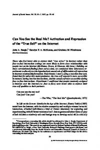
TrafficView _
+
N W
E S
Toolbar: Zoomin, Zoomout, Road status, Directions, etc.
1
Slide bar for areas infront or behind you
Other cars
Your car Title
1
Gas station 3 miles ahead on right Accident 10 miles ahead on first lane
Messages, Alerts, Ads, etc.
Figure 1. Example of Traffic Information Displayed by TrafficView
or finding an optimal route in a trip several miles long. Figure 1 shows an example of traffic information displayed to a driver by a TrafficView device.
2. Problem Description Given a set of moving vehicles on the road, the goal is to exchange information about the position and speed of those vehicles among themselves to enable each individual vehicle to view and assess traffic and road conditions in front of it. As the vehicles move along the road, they might enter the transmission range of some vehicles, and exit that of others. Two main mechanisms could be used to achieve this goal: flooding and diffusion. In the flooding mechanism, each individual vehicle periodically broadcasts information about itself. Whenever a vehicle receives a broadcast message, it stores it and immediately forwards it by rebroadcasting the mes-
Figure 2. TrafficView on the Road sage. This mechanism is clearly not scalable, due to messages flooded over the network, especially in high density roads. In the other mechanism — the diffusion mechanism — each vehicle broadcasts information about itself and the other vehicles it knows about. Whenever a vehicle receives information broadcast by another vehicle, it updates its stored information accordingly, and defers forwarding the information to the next broadcast period, at which time it broadcasts its updated information. The diffusion mechanism is scalable, since the number of broadcast messages is limited, and they do not flood the network. We use the diffusion mechanism in TrafficView. Figure 2 shows how the cars in TrafficView form a mobile ad hoc network and disseminate traffic information using only car-to-car communication.
3. Data Aggregation Algorithm In order to deliver as much information about other vehicles as possible within the limited wireless bandwidth, data compression/aggregation techniques should be applied to the records exchanged. Data compression and aggregation are two different concepts. Data compression is a binary operation in the sense that it does not base the decisions made on the semantics of the data. Moreover, data compression techniques require a lot of computation resources which is not suitable for most portable devices. Therefore, we only focus on data aggregation mechanisms in TrafficView. Data aggregation is based on the semantics of the data. For example, the records about two vehicles can be replaced by a single record with little error, if the vehicles are very close to each other and move with relatively the same speed; in other words, their relative distance is always in a small range. The way data aggregation contributes to the TrafficView system is by delivering as many records as possible in one broadcast message. Thus, more new records can be delivered in a certain period of time and the overall system performance is improved. In one of our previous papers [1], we studied two main aggregation mechanisms; ratio-based and cost-based. The main idea of the ratio-based algorithm is to divide the road in front of a vehicle into regions, and aggregate more records in farther away regions. On the other hand, the cost-based algorithm assigns a cost to aggregating each two records, and whenever
Figure 3. Hardware components used in the TrafficView prototype
it needs to aggregate two records, the ones that result in the smallest cost are chosen. We also studied mechanisms for invalidating expired information stored locally by each vehicle (information aging).
4. Prototype Implementation and Performance Evaluation We implemented a TrafficView prototype on top of Linux. This prototype has a highly accurate road identification module and disseminates data in the form of UDP packets. As testbed, we used laptops and HP iPAQ handhelds. We obtained the information about location, time, and speed from a GPS receiver attached to each laptop or iPAQ. Optionally, our prototype can get the vehicle’s status (e.g., speed, mechanical parameters, or electrical parameters) using the OBDI-II interface available in cars and a DSP-100 card connected to the laptops or iPAQs. For communication, we used 802.11b cards. Figure 3 presents the hardware components used in our prototype. We evaluated TrafficView on real highways [2] and using the ns-2 network simulator [1]. Our results showed that average vehicle speed has less effect on the performance on different algorithms, whereas average gap affects their performance (especially visibility) directly. We also concluded that the ratio-based algorithm provides more flexibility through its parameters that allow us to achieve better visibility while maintaining a good coverage percentage and very small position estimation error.
5. TrafficView Demo Description The goal of the demo is to illustrate the use of TrafficView in real world traffic scenarios. The demo will demonstrate how TrafficView displays the traffic information even in situations where the cars ahead of a certain car are not physically visible from that car. The demo will consists of two parts:
• Each iPAQ will display the information about the cars it knows according to the information it extracts from the received packets. To validate the display, an additional laptop will run a program that displays the cars positions using the GPS traces of all the iPAQs. The TrafficView configuration that we will use at the conference consists of one laptop and multiple HP iPAQs (about five or six), running Linux, and equipped with 802.11 PC cards.
References
Figure 4. Video snapshot of TrafficView experiment with 3 cars on US Highway 1, in New Jersey
1. A number of movies that show, in parallel, the cars on the road and the information displayed by TrafficView in one of those cars. Each movie corresponds to a different traffic scenario. Figure 4 presents a snapshot from a movie that shows a preliminary experiment with three cars on US Highway 1, in New Jersey. The left part shows two of the three cars on the road as seen by the third car, while the right part shows the information available to the driver in the third car. 2. An emulation of the same traffic scenarios using HP iPAQs that will represent the computers embedded in cars. Each iPAQ will display the information corresponding to one car. TrafficView will be adapted to work indoors to be suitable for the conference demo as follow: • For each iPAQ, we will use a GPS trace file corresponding to the real GPS readings from one of the cars used in the road experiment. Each reading in the trace file will be augmented with its timestamp from the the real road experiment. All the measured times are with respect to a global ZERO time set by the experiment. • Initially, all the iPAQs will initialize their clock to this origin time in order to synchronize with each other. • Each iPAQ will update its location by reading the GPS-provided position from the next record in the trace file at the time associated with the record. Then, the iPAQ prepares and broadcasts the TrafficView packet. • To emulate the transmission ranges, when an iPAQ receives a TrafficView packet, it checks the GPS reading corresponding to the car that broadcasted such packet against its local GPS reading. If the distance between the two cars are above the transmission range, the packet will be dropped. Otherwise the iPAQ will accept the packet and start to process it normally.
[1] T. Nadeem, S. Dashtinezhad, C. Liao, L. Iftode, “TrafficView: A Scalable Traffic Monitoring System,” Proceedings of the 2004 IEEE International Conference on Mobile Data Management (MDM 2004), Berkeley, GA, Jan. 2004. [2] S. Dashtinezhad, T. Nadeem, B. Dorohonceanu, C. Borcea, P. Kang, L. Iftode, “TrafficView: A Driver Assistant Device for Traffic Monitoring based on Car-to-Car Communication,” Proceedings of the IEEE Semiannual Vehicular Technology Conference, Milan, Italy, May 2004.