Earth-Science Reviews 126 (2013) 74–84
Contents lists available at ScienceDirect
Earth-Science Reviews journal homepage: www.elsevier.com/locate/earscirev
Virtual Geographic Environments (VGEs): A New Generation of Geographic Analysis Tool Hui Lin a,b,c, Min Chen a,b,⁎, Guonian Lu d, Qing Zhu e, Jiahua Gong f, Xiong You g, Yongning Wen d, Bingli Xu h, Mingyuan Hu a,b a
Institute of Space and Earth Information Science, The Chinese University of Hong Kong, Shatin, Hong Kong, PR China Shenzhen Research Institute, The Chinese University of Hong Kong, Shenzhen, 518057, PR China Department of Geography and Resource Management, The Chinese University of Hong Kong, Shatin, Hong Kong, PR China d Key Laboratory of Virtual Geographic Environment, Ministry of Education of PRC, Nanjing Normal University, Nanjing, 210046, PR China e Faculty of Geosciences and Environmental Engineering of Southwest Jiaotong University, Chengdu, 611756, PR China f State Key Laboratory of Remote Sensing Science, Institute of Remote Sensing and Digital Earth, Chinese Academy of Sciences, Beijing, 100101, PR China g Zhengzhou Institute of Surveying and Mapping, Zhengzhou, 450052, PR China h Department of Information Engineering, Academy of Armored Forces Engineering, Beijing, 100072, PR China b c
a r t i c l e
i n f o
Article history: Received 13 November 2012 Accepted 3 August 2013 Available online 14 August 2013 Keywords: Virtual Geographic Environments (VGEs) Spatial analysis Interaction Geographic phenomenon simulation Collaborative geographic experiment
a b s t r a c t Virtual Geographic Environments (VGEs) are proposed as a new generation of geographic analysis tool to contribute to human understanding of the geographic world and assist in solving geographic problems at a deeper level. The development of VGEs is focused on meeting the three scientific requirements of Geographic Information Science (GIScience) — multi-dimensional visualization, dynamic phenomenon simulation, and public participation. To provide a clearer image that improves user understanding of VGEs and to contribute to future scientific development, this article reviews several aspects of VGEs. First, the evolutionary process from maps to previous GISystems and then to VGEs is illustrated, with a particular focus on the reasons VGEs were created. Then, extended from the conceptual framework and the components of a complete VGE, three use cases are identified that together encompass the current state of VGEs at different application levels: 1) a tool for geo-object-based multi-dimensional spatial analysis and multi-channel interaction, 2) a platform for geo-process-based simulation of dynamic geographic phenomena, and 3) a workspace for multi-participant-based collaborative geographic experiments. Based on the above analysis, the differences between VGEs and other similar platforms are discussed to draw their clear boundaries. Finally, a short summary of the limitations of current VGEs is given, and future directions are proposed to facilitate ongoing progress toward forming a comprehensive version of VGEs. © 2013 The Authors. Published by Elsevier B.V. All rights reserved.
Contents 1. 2. 3.
Introduction . . . . . . . . . . . . . . . . . . . . . . . . . . . . . . . . . . . . . . . . . . Evolution from maps to previous GISystems then to VGEs . . . . . . . . . . . . . . . . . . . . . . Use cases of VGEs . . . . . . . . . . . . . . . . . . . . . . . . . . . . . . . . . . . . . . . . 3.1. A tool for geo-object-based multi-dimensional spatial analysis and multi-channel geo- interaction 3.2. A platform for geo-process-based simulation of dynamic geographic phenomena . . . . . . . . 3.3. A workspace for multi-participant-based collaborative geographic experiments. . . . . . . . . 4. Differences between VGEs and other similar platforms . . . . . . . . . . . . . . . . . . . . . . . 5. Future works and conclusion . . . . . . . . . . . . . . . . . . . . . . . . . . . . . . . . . . . Acknowledgments . . . . . . . . . . . . . . . . . . . . . . . . . . . . . . . . . . . . . . . . . . References. . . . . . . . . . . . . . . . . . . . . . . . . . . . . . . . . . . . . . . . . . . . . .
. . . . . . . . . .
. . . . . . . . . .
. . . . . . . . . .
. . . . . . . . . .
. . . . . . . . . .
. . . . . . . . . .
. . . . . . . . . .
. . . . . . . . . .
. . . . . . . . . .
. . . . . . . . . .
. . . . . . . . . .
. . . . . . . . . .
. . . . . . . . . .
. . . . . . . . . .
. . . . . . . . . .
. . . . . . . . . .
. . . . . . . . . .
. . . . . . . . . .
. . . . . . . . . .
. . . . . . . . . .
. . . . . . . . . .
74 76 77 77 79 80 81 81 82 82
1. Introduction ⁎ Corresponding author at: Institute of Space and Earth Information Science, The Chinese University of Hong Kong, Shatin, Hong Kong, PR China. Tel.: +852 53982798; fax: +852 26037470. E-mail address:
[email protected] (M. Chen).
The scientific issues regarding Geographic Information Science (GIScience) have arisen in five future scenarios (Goodchild, 2009a, 2010), among which multi-dimensional visualization, dynamic phenomenon simulation, and public participation are the three key points.
0012-8252/$ – see front matter © 2013 The Authors. Published by Elsevier B.V. All rights reserved. http://dx.doi.org/10.1016/j.earscirev.2013.08.001
H. Lin et al. / Earth-Science Reviews 126 (2013) 74–84
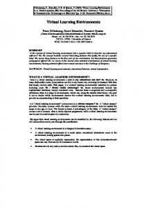
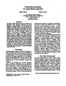
To address these issues, the corresponding tools that are used to assist in the study of geography should be improved in a continuous and efficient manner to meet the scientific requirements and further the evolution of GIScience. As a new form of geographic analysis tool and also an extension of Michael Batty's virtual geography theory (Batty, 1997), VGEs are a type of typical web- and computer-based geographic environment built for geographic understanding and problem solving (Lin and Gong, 2001, 2002). By merging geographic knowledge, computer technology, virtual reality technology, network technology, and geographic information technology, VGEs are built with the objective of providing open, digital windows into geographic environments in the physical world, to allow users to ‘feel it in person’ by a means for augmenting the senses and to ‘know it beyond reality’ through geographic phenomena simulation and collaborative geographic experiments (Lin and Zhu, 2006; Batty, 2008; Lin and Batty, 2009; Konecny, 2011; Lu, 2011; Priestnall et al., 2012; Lin et al., 2012). Consequently, a complete VGE (see Fig. 1) should be designed with four components: the data component, the modeling and simulation component, the interactive component, and the collaborative component, which are responsible for geographic data organization, the implementation of geographic modeling and simulations, interactive channel construction, and collaborative tool design, respectively (Lu, 2011; Lin et al., 2013). Including the above components enables the construction of two cores, namely a geo-database and a geographic process model base. Furthermore, virtual geographic scenarios can be constructed to enable both public and scientific researchers to explore geographic phenomena and to address geographic issues (Lin et al., 2009, 2010a). For example, in a VGE built for air pollution analysis (Fig. 2), by the researchers, not only can static virtual geographic scenarios, including the background environments and objects (both discrete objects such as chimneys and continuous objects such as pollutants), be represented and analyzed, but future pollution trends can also be predicted because the geographic process models (e.g., the Weather Research and
75
Forecasting Model and the Community Multi-scale Air Quality Model) can be integrated for the simulation of dynamic diffusion processes. The public can thus (1) experience the visualized ‘real world’, revisit the past, and explore the future as avatars through interactive channels; (2) understand the relations between air quality and related factors (e.g., climatic change and the distribution of pollution sources) more deeply; and (3) contribute their feedback and virtual spatial activities (e.g., reducing their driving) in the digital environment, which may transform virtual situations for further experiments and prediction. Moreover, general understanding can be acquired more easily by viewing and experiencing such a digital geographic world than by viewing various figures and tables. Thus, collaborative exploration can be conducted more conveniently than by using previous systems. For example, experts from meteorology, chemistry, and geography can perform virtual experiments through the network, collaborating with decision-makers in different offices across the globe. From the above-described perspectives, the scientific issues concerning the building of VGEs naturally coincide with Goodchild's three key points. There is a need, therefore, to produce a detailed review and to add clarity to VGEs. The present work not only traces the evolutionary course of geographic analysis tools in past years, but it will also promote the development of GIScience in the coming decades of the twenty-first century. Examining ten years of continuous exploration, this article provides a clearer description of VGEs, including the reason for their creation, their detailed functions and distinct features, and the current limitations and future directions surrounding these technologies. The remainder of this article is organized as follows: the evolutionary process, from maps to previous GISystems then to VGEs, is illustrated in Section 2. To provide an effective basis for understanding complex systems, Section 3 identifies three use cases that together encompass the current state of VGEs at different application levels. Progress to date is also reviewed for each use case. Section 4 discusses the differences between VGEs and other similar platforms. The article concludes with a summary and presentation of future directions for VGEs.
Fig. 1. Structure of a complete VGE.
76
H. Lin et al. / Earth-Science Reviews 126 (2013) 74–84
Fig. 2. A VGE example built for air pollution analysis.
2. Evolution from maps to previous GISystems then to VGEs Human understanding of the geographic world is a gradual process, during which different requirements are presented from the elementary to the profound. There are three primary stages of geographic understanding. The first stage is to acquire geographic information; the second stage is to study geo-objects (e.g., their shapes and distributions) and their relationships using topological, geometric, or geographic
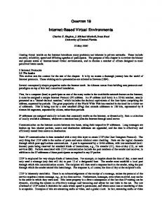
property information; and to further explore advanced geographic laws, the third stage is to analyze dynamic geographic phenomena and processes (Mark et al., 1999). To meet the different requirements needed for this understanding, corresponding tools have evolved accordingly. Fig. 3 illustrates this process and the corresponding tools. Here, we focus on the evolution from maps to previous GISystems and then to VGEs.
Fig. 3. The development of tools according to the evolution of human understanding of the geographic world.
H. Lin et al. / Earth-Science Reviews 126 (2013) 74–84
A map is a graphic representation or scale model of spatial concepts that records and communicates spatial information concerning the physical and social aspects of the environment (Campbell, 2001; Aber, 2007). Maps were first used as schematic tools to identify locations and directions. With the development of cartographic techniques, such as the establishment of the meridian, the division of latitude and longitude, and the design of various projection methods and abstract symbols, maps were able to communicate geographic features and spatial distributions to humans (Crone, 1968; Bagrow and Skelton, 2009). In recent years, as computer technology has greatly popularized maps in the form of electronic maps and network maps, maps have become the most effective way to answer the question “where is it?” and the basic tool for understanding locations and geographic features of an area in daily life (Geoffrey and Preston, 1993; Wood and Fels, 2008). As an extension of maps, GISystems are rooted in computer mapping and spatial database management, with spatial analysis as their key component (Goodchild, 1987; Longley, 2000a; Longley et al., 2011). The analytical approaches of GISystems have evolved as much as their mapping capabilities and practical expressions, and their analytical capabilities have taken users well beyond mapping (Berry, 1997, 2009; Longley, 2000b). Numerous examples illustrate the successes of GISystems in both natural and social fields (e.g., Khan et al., 2006; Konecny et al., 2010; Richardson et al., 2013). However, considering the recently proposed scientific issues concerning GIScience, e.g., that GIScience should evolve from being data driven to concept and theory driven, from static to dynamic, and from pattern presentation to process modeling/simulation (Goodchild, 2009a), previous GISystems still lack the realm of evidence, knowledge and ultimately wisdom to fully assess the earth system (Longley et al., 2011). Previous GISystems must improve in several areas. First, dynamic phenomena occur at all times and places in the geographic world (e.g., rainfall, accordant junctions, and evaporation); therefore, it is necessary to model the geographic environment as a dynamic system (Batty, 1971; Flower et al., 1998, 2004). However, previous GISystems have been criticized because they did not adequately accommodate knowledge regarding the dynamic aspects of the earth's surface, and insufficiently accounted for the geographic phenomena that are continuously dispersing or propagating in space and time (Goodchild, 2008a; Bothwell and Yuan, 2010). Second, several researchers have noted that GISystems should involve the public by placing them and their spatial knowledge on equal footing with experts and decision-makers (e.g., Carver, 2001a; McCall, 2003; Duncan, 2006). However, previous GISystems lacked the high level of interactivity required to efficiently support collaborative and participative processes (Jankowski and Nyerges, 2001), and their user interfaces were often too complex for non-experts (Carver, 2001b). Although several systems that encourage public participation have been proposed, such as the Participatory GISystem (PGIS) and the Public Participation GISystem (PPGIS) (Abbot et al., 1998; Carver et al., 2001), sufficiently interactive and attractive interfaces for convenient participation are still urgently needed from the informational perspective to support information collection, collaborative experimentation, and decision-making, particularly when non-expert participants are involved (Jankowski and Nyerges, 2001; Balram and Dragicevic, 2006; Elwood, 2006; McHugh et al., 2009). Recently, virtual environments have shown immense potential for scientific research (Bainbridge, 2007). In the geographic research field, VGEs were proposed as an evolutionary step beyond maps and previous GISystems for geographic analysis. The term ‘geographic environment’ has long been accepted as a description of the surfaces on which human societies exist and develop (Churchill and Friedrich, 1968). The geographic environment surrounds each person in his or her life, including in images and in memory. Building digital windows into geographic environments, i.e., VGEs, for geographic understanding and problem solving is expected to overcome the defects of previous GISystems on some levels. On one hand, as defined, a VGE is generally built with two cores — a geo-database and a geographic process
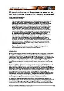
77
model base. Here, it is worth mentioning that, as opposed to spatial analysis (e.g., network analysis) and spatial statistical analysis algorithms that are employed by previous GISystems, geographic process models refer to models that are used for dynamic geographic process computing (e.g., the Gaussian Plume Model for the calculation of air pollutant dispersion, the Weather Research and Forecasting Model for climate computing, and the MIKE SHE Model for water flow simulation). Combining such geographic process models with GISystem-based analyses can improve the understanding of gradual geographic evolution and allow for new quantitative and systematic examinations of spatial and temporal patterns of dynamic geographic processes (Napieralski et al., 2007). On the other hand, as knowledge sharing is becoming more and more important both for scientific research and daily life, a visualized virtual environment can provide another practical opportunity for idea exchange, as opposed to using only abstract representations, and this visualized environment can create a better experience for users, particularly for the public (Bainbridge, 2007). By merging the virtual environment with geographic concepts, e.g., geographic coordinates, geographic scales, and regional features, VGEs can help the user better understand geographic information through multi-sensory interaction and, hence, improve understanding of real-word patterns and processes. In this case, VGEs can lay a solid foundation for convenient manipulation and communication, which will further contribute to the attraction of more users and the collection of more geographic knowledge. 3. Use cases of VGEs The formal process of system design begins with the identification of use cases, and the understanding process also starts with the cognition of these use cases (Goodchild, 2008b, 2012a). To improve the recognition of VGEs, this section takes a similar perspective, focusing on illustrating use cases of VGEs at different application levels. Based on the combination of different components of a complete VGE, these use cases of VGEs can be divided into three levels (see Fig. 4). 3.1. A tool for geo-object-based multi-dimensional spatial analysis and multi-channel geo- interaction Spatial analysis and visualization are the basic functions of geographic information tools (Longley et al., 2011). However, with the increasing requirements of spatial cognition, traditional spatial analysis and visualization in 2D cannot meet the advanced needs of geographic researchers or the public, particularly when solving problems related to complex spaces. The tendency is, in recent years, with the development of 3D data models (e.g., facial models, volumetric models, discrete models, and continuous models) and visualization-related technologies (e.g., levels of detail, graphics processing unit-based rendering, and distributed scheduling), 3D spatial analysis functions are increasingly integrated into modern geographic analysis tools and 3D visualization systems (e.g., Google Earth, World Wind, Skyline) have become popular (Brooks and Whalley, 2008; Pouliot et al., 2008; Aliaga et al., 2009; Borrmann and Rank, 2009; Wycisk et al., 2009). From the perspective of spatial analysis, systems with 3D spatial analysis functions can enable more powerful analyses, such as sunlight analysis (e.g., Al-Shalabi et al., 2006; Bansal and Pal, 2009; Yasumoto et al., 2012), the network analysis of underground objects (e.g., Pubellier, 2003; Rienzo et al., 2009; Balogun et al., 2011), and 3D path-finding analysis and navigation (e.g., Kwan, 2005; Sobata et al., 2008; Becker et al., 2009), compared with systems with 2D spatial analysis functions. In terms of visualization, geographic information expressed in 2D is generally abstract and limited, which is difficult for non-experts to understand. Multidimensional visualization enables the presentation of geographic scenarios and phenomena to be more dynamic. This capability can also contribute to geographic experiments involving the public because easily understood scenarios can enhance their response capacity and allow
78
H. Lin et al. / Earth-Science Reviews 126 (2013) 74–84
Fig. 4. Different levels of use cases based on the combination of the components of VGEs.
them to make full use of their experience from the real world once they are willing to provide their spatial knowledge (Mania et al., 2010). These developments have enabled VGEs to be a potentially suitable tool for advanced geographic analysis and visualization (MacEachen et al., 1999; MacEachen and Kraak, 2001; Chen et al., 2008a). On one hand, examples have shown that virtual environments have greatly benefitted scientific analysis and visualization (Bainbridge, 2007). On the other hand, the data component in a VGE, which is responsible for multi-dimensional geographic data organization and management, and the interactive component, which is responsible for providing interactive channels between users and the VGEs, are essentially designed to meet the geographic requirements described above (Lu, 2011; Lin et al., 2013). Generally, the physical world consists of discrete objects with clear boundaries (e.g., a rock or a building) and continuous fields without clear boundaries (e.g., soil and grass). Interest in the changes of these geo-objects over time has intensified. To build virtual scenarios similar to those of the real world and to support complex, multi-dimensional (including time) spatial analysis, the design of the data model, rather than visualization alone, is the key issue when building a VGE. Several theories, e.g., space subdivision, fluid dynamics, and (non-) manifold theory, have been previously applied to create data models for spatial analysis in complex 3D environments (e.g., Lin, 1997; Kneller and Buckee, 2002; Coors, 2003; Arens et al., 2004; Hustoft et al., 2007; Boguslawski and Gold, 2009; Paris et al., 2009). However, to support multi-dimensional geographic process simulations, there is a growing need to integrate time dimensional information with geometrical information when designing a data model for organizing geo-objects, and the representation and computing efficiency of data models remain a significant challenge. Recently, studies have focused on introducing geometric algebra theory into spatial data modeling in VGEs (Li, 2008; Yuan et al., 2010a,b; Yuan et al., 2012a,b,c). Geometric algebra theory has been widely used in computer vision, artificial intelligence and other related fields for more than a decade (e.g., Hestenes, 2002, 2003; Doran and Lasenby, 2003; Dorst et al., 2007; Perwass, 2009). The difference is this type of theory uses dimensional calculations as the bases for geometric operations; thus, multi-dimensional space is defined as the operations of a series of vector sets. In terms of this theory, two vectors, e.g., a and b can be expressed as ab =a · b + a ∧ b, in
which a · b can be regarded as the inner product, and a ∧ b can be seen as the outer (or exterior) product. Both the inner and outer products are dimension-related. The former can decrease the number of dimensions when calculating, and the latter can increase the number of dimensions and help to construct the shape of geo-objects. In this way, scalar and vector, dimensional and geometric operations are unified into one single equation to reduce the difficulty of constructing complex, high-dimensional geometric shapes, laying a solid foundation for the multi-dimensional expression and analysis of geo-objects (Yuan et al., 2012a). Fig. 5 shows the examples of a multi-dimensional spatial analysis of the sea, land, and ice layers in the South Pole in a VGE, using a data model built with geometric algebra theory (Yuan et al., 2012b). Although some progress has been made, to date, there is still no unified data model that can fully satisfy the construction of VGEs for different applications. This lack of a unified model is the same problem noted for data models designed for previous GISystems. Some researchers have explored data representation models for data exchange among different VGEs and other systems (e.g., Su et al., 2008; Chen et al., 2009a), but semantic heterogeneity is another big problem that needs to be solved in the future (Lin et al., 2013). In terms of geo-interaction, as noted above, VGEs have great potential to support multi-dimensional visualization (MacEachen and Kraak, 2001), but they are not restricted to visualization. It fact, other senses, in addition to vision (e.g., hearing, touch, smell, and taste), can also greatly enhance the perception of the world. Early in 2005, Goodchild argued that to aid participants in analyzing geographic phenomena and communicating geographic knowledge in a more realistic way, new tools for geographic analysis should be developed with virtual reality technologies and should be equipped with a means for augmenting the senses (Goodchild, 2005). Compared with systems using 2D environments, a VGE can provide stereo expression of geo-objects and scenarios based on geographical similarity theory, which lays an essential foundation for manipulating geo-objects and experiencing geographic phenomena as though these phenomena were being experienced in person (Cartwright et al., 2005; Lin et al., 2013). In addition to a mouse or keyboard, language, gestures, or drawing can also be introduced as interactive channels in VGEs to enable more comfortable manipulation. Recently, increasing multi-channel interaction-related theoretical research (e.g., Loomis et al., 1998; Jansson and Pedersen, 2005;
H. Lin et al. / Earth-Science Reviews 126 (2013) 74–84
79
Fig. 5. Multi-dimensional spatial analysis in a VGE with a data model built using geometric algebra theory. Modified from Yuan et al. (2012b).
Bowman, 2007; Dede, 2009) has been discussed and applied in the construction of VGEs, and thus, multi-channel interfaces have increasingly appeared in VGEs, both for researchers' analyses as well as for public participation (e.g., Johnson et al., 2006; Limniou et al., 2008; Slater, 2009; Paolis et al., 2011). 3.2. A platform for geo-process-based simulation of dynamic geographic phenomena According to Goodchild, in the near future, the research paradigm of GIScience will change from static snapshots to dynamic phenomena (Goodchild, 2004, 2009a, 2010). In fact, geo-processes, which change continuously across both spatial and temporal dimensions, have already demonstrated their ability in driving geographic spatial patterns and distributions (Hofer, 2009; Hofer and Frank, 2009). To assist in the understanding of comprehensive and gradually evolving geographic problems, conducting dynamic geographic phenomena simulation with geographic process models is currently one of the most popular approaches, with which not only past and current scenarios can be reproduced and analyzed, but future situations can also be predicted as well (He, 2002; Maguire et al., 2005). To date, many geographic process models related to various geoprocesses have been created and applied in disciplines ranging from geo-physical studies (e.g., Wilson and Hamilton, 1996; Gordon et al., 2000; Verburg et al., 2002; Miall and Miall, 2004; Takle et al., 2006; Rinaldi and Darby, 2007; Chin et al., 2010) to human spatial behavior exploration (e.g., Golledge and Stimson, 1997; Moulin et al., 2002; An et al., 2005). To fully utilize these model resources and to explore the mechanisms behind geo-processes more conveniently, researchers from the geographic and computer fields have been working to couple these models into geographic analysis tools (e.g., Kemp, 1996; Olivera et al., 2006; Ruelland et al., 2007), resulting in the development of several projects for model building and sharing, including the Modular Modeling System (MMS) (Leavesley et al., 1996), the Spatial Modeling Environment (SME) (Maxwell and Costanza, 1997), the Interactive
Component Modeling System (ICMS) (Reed et al., 1999), the Community Surface Dynamic Modeling System (CSDMS) (CSDMS Working Group, 2004), the Earth System Modeling Framework (ESMF) (Hill et al., 2004), the Open Modeling Interface (OpenMI) (Blind and Gregersen, 2005; Moore and Tindall, 2005), the European Union's Program for Integrated Earth System Modeling (PRISM) (Valcke et al., 2006), the SEAMLESS-IF (Van Ittersum et al., 2008), and CAPRI (Britz et al., 2010). Although these projects are valuable references, most of them are highly field-related and difficult for experts from other fields to use, which limits the breadth of application of these tools and increases the entry barriers to these systems (Feng et al., 2011; Nativi et al., 2012). Moreover, to date, technologies related to model sharing and integration over the Internet have not been widely incorporated into these projects (Wen et al., 2012). Research into VGEs tries to provide multidisciplinary experts with a platform with which to create, re-use, and implement distributed geographic process models that allow for more convenient geographic process modeling and simulation (Lu, 2011; Lin et al., 2013). Several key issues have been given substantial attention in the modeling and simulation component of building a VGE. Supporting conceptual modeling is the first of these issues. A conceptual model is the representation of a geographic phenomenon at a certain level of approximation externalized in a semiformal or formal language (Wand and Weber, 2002). Conceptual modeling is the first step of geographic modeling and simulation, and a high-quality conceptual modeling process can facilitate the early detection and correction of modeling errors (Krogstie and Sùlvberg, 2003). Related solutions have been proposed, for example, in some projects, the concept of geo-objects and their relationships were represented by geographic conceptual icons and directed lines respectively, and the geographic conceptual models were then built by dragging those elements into a geographic conceptual scenario in a guided way (Chen et al., 2008b, 2011a). However, the practical applicability of these conceptual modeling methods still needs to be further verified because model semantics are generally heterogeneous; therefore, organizing and attaching model semantics in a normalized way
80
H. Lin et al. / Earth-Science Reviews 126 (2013) 74–84
with conceptual geographic scenarios requires further study. Another key issue in the modeling and simulation component of VGEs is the sharing and integration of computational models through the Internet. In reference to this issue, the design of model specifications, model coupling mechanisms, and model distributed execution strategies should be seriously examined in the construction of the modeling and simulation component of VGEs. Related research has been reported in several studies (e.g., Ogle and Barber, 2008; Chen et al., 2009b; Fook et al., 2009; Geller, 2010; Wen et al., 2012), and the abilities of VGEs are expected to be enhanced to satisfy further requirements of the updated network environment, such as cloud computing. From the perspective of end users of dynamic geographic phenomena simulations, using VGEs as a platform has several advantages. First, VGEs provide sensible environments for users to gain an intuitive feeling of dynamic phenomena, making simulation process easy to handle and allowing for the results to be more easily understood (Mekni, 2010; Xu et al., 2010, 2013; Chen et al., 2011b). Second, the evolution of geographic processes is often influenced by interactions among several small processes related to different fields. For example, the development of urban areas might be affected by river resources, air pollution, land use, and population (Chin, 2006), and climate change might be caused by both environmental factors (e.g., atmospheric circulation) and human social activities (e.g., overexploitation of natural resources and energy) (Miall and Miall, 2009). A VGE would provide a platform for researchers to gain a systematic understanding as if they were in the real world based on their common sense. They could then conduct a comprehensive analysis of the earth system by integrating multidisciplinary models in a visual and formalized mode (Haddad and Moulin, 2008; Chen et al., 2011a). Third, combining VGEs with real-time sensor data can greatly enhance the accuracy of geo-simulation in a reality–virtuality fusional mode. For example, on one hand, VGEs could provide virtual scenarios that correspond to the physical world, so that the real-time data stream (e.g., data acquired from sensor networks), which facilitate the study of fundamental processes and the development of earth systems (Hart and Martinez, 2006), could be easily imported as the input parameters for the simulation according to their actual positions. On the other hand, data produced during simulation processes could also be used to reform continuous visual scenarios. After making comparisons with the real monitored data, it would be useful for researchers to adjust the control parameters in a timely manner and thus improve the accuracy of the simulation (Che et al., 2011; Xue et al., 2012). Lastly, although coupling problems currently exist, when simulationrelated geographic data and multi-scale process models can be integrated seamlessly by the data component and the modeling and simulation component, the use of a VGE would support the simulation of multiscale geographic phenomena because the virtual scenarios could be created at different scales and transformed by ‘zoom in’, ‘zoom out’ or other geographic operations, and the geographic process models at corresponding scales could thus be called for analysis. For example, beginning with a global view, macro-scale phenomena such as ocean circulation, diastrophism, and monsoon evolution can be simulated and expressed. When zoomed in, run-off variation, water and soil loss, and soil erosion can be studied at the meso-scale. At the micro-scale, human behavior within a city or small region can be explored. 3.3. A workspace for multi-participant-based collaborative geographic experiments Geography is a comprehensive subject involving both natural and human factors and their interactions; therefore, related research topics cover various disciplines (e.g., geomorphology, hydrology, soil science, biology, climate science, and social science), and the focus is on exploring the interactive mechanisms of surface processes (Murphey, 1982; Armstrong, 2000). In reality, the surface processes of geographic systems cannot be treated separately (Neumann et al., 2010). To conduct
comprehensive research on complex geographic problems, modern geography is developing in a positive direction that promotes integrated study from an integrated perspective (Wright and Gale, 2003). In this regard, collaborative work is a significant requirement for geographic research and applications. Geographic collaboration has been defined by MacEachren et al. as having two facets: (1) ‘as an activity’ which is ‘group work about geographic problems facilitated by geospatial information technologies’; and (2) ‘as a field of research’ which is ‘the study of these group activities, together with the development of methods and tools to facilitate them’ (MacEachren et al., 2003). These two aspects of geographic collaboration require a facilitative workspace to engage both the experts and the public to collaboratively contribute their own knowledge. In this case, providing a VGE for multi-participant based geographic collaboration, e.g., collaborative geographic experiments, would have two major advantages, both for professional and non-professional participants. First, a reasonable solution for scientific research on complex geographic problems is to engage dispersed multi-disciplinary experts to discuss problems, perform experiments, and find optimal answers together through collaborative modes, such as by joining a virtual group through the Internet (Hara et al., 2003). To enable these experts to share knowledge, present opinions, review work, post suggestions, and give comments to each other, the hot spot research regions, physical phenomena, and other related elements should be shared before the discussion. However, different experts have different understandings of these elements of discussion. Discussing problems under different abstraction modes will increase the difficulty of this collaboration. In this respect, according to Churchill et al. (2001) and Abel et al. (2005), a better method for knowledge sharing is to provide visual objects and common phenomena that are easily recognized and illustrated in a familiar way. Combining this idea of providing visual objects and common phenomena with multi-dimensional geographic data and geographic process models, a VGE could provide virtual environments corresponding to the real geographic world. These virtual environments would be familiar to most researchers as environments seen in their daily lives and would be convenient to describe. Compared with systems that use abstract or professional symbols to represent geographic information, these shared visual and familiar geographic scenarios would create a better universal and imaginable understanding of process and thus, would enable groups of geographically disparate users to work together by using common information spaces. Examples of this type of collaboration have appeared in several fields, such as silt dam planning, pollution analysis, and moon exploration (e.g., Gong and Lin, 2006; Zhang et al., 2007; Zhu et al., 2007; Lin et al., 2010b; Xu et al., 2011; Chen et al., 2012). Second, social factors are very important for comprehensive geographic research, especially for geographic experiments which ought to combine the natural and social worlds under one explanatory umbrella (Matthews and Herbert, 2008). To include social factors in geographic experiments, the most commonly used method is to collect social data using methods such as surveys or statistics and then integrate those data into the analysis tools (e.g., McLafferty, 2002, 2006). Recently, game-oriented virtual environments, such as second life, have been used to collect spatial behavior (e.g., Friedman et al., 2007; Pelachaud et al., 2007). However, the exploration of physical geographic phenomena and related serious collaborative experiments is difficult to carry out because real geographic scenario and laws are often lacking in these virtual environments (Chen et al., 2013). In this respect, a VGE would be a more appropriate tool than a gameoriented virtual environment from the geographers' perspective (Hu et al., 2011). Cognitive psychologists have suggested that people will behave more similarly if they are in similar surroundings (Tversky, 2005; Taylor et al., 2008). Thus, by providing familiar virtual geographic scenarios and user-friendly interactive tools, a VGE that is built based on real geographic features would enable the public to act more naturally and give more reasonable judgments so that social factors could be
H. Lin et al. / Earth-Science Reviews 126 (2013) 74–84
incorporated in a more appropriate way (Goodchild, 2009b; Mania et al., 2010). For example, the public can interact with the contents of the virtual world and communicate with one another as they are in the real world. They can also behave creatively in a Virtual Geographic Environment (e.g., plant trees or reduce automobile emissions), which may stimulate them to be more willing to share their own knowledge. Moreover, in collaboration with researchers' analyses and simulations, these behaviors and the knowledge collected from VGEs will further contribute to geographic experiments and decision-making (Lin and Zhu, 2006; Lai et al., 2010). 4. Differences between VGEs and other similar platforms The three levels of use cases described in the previous section suggest several conclusions regarding the differences between VGEs and other platforms. First, VGEs are different from current digital cities (e.g., Ishida, 2002), virtual communities (e.g., Rheingold, 2000), virtual reality environments (e.g., Rheingold, 1991; Steuer, 1992; Burdea and Coiffet, 2003), augmented reality environments (e.g., Azuma, 1997; Regenbrecht and Wagner, 2002), virtual worlds (e.g., Bartle, 2003) and other such virtual environments. A VGE is built for geographic analysis, and its primary objective is to solve comprehensive geographic problems. However, the purposes of the other systems listed above are different. For example, a virtual community is a social network of individuals who interact through specific social media, and it is designed for social interaction between community members who vary from personal to purely formal (Rheingold, 2000). As another example, most current virtual reality environments are primarily designed for visual experiences. Although VGEs are built based on virtual reality technologies, they are different from virtual reality environments because VGEs are equipped with real geographic features, mechanisms, and laws, which are intended to be used for geographic problem solving. In particular, VGEs are used not only for the reproduction of past or current geographic scenarios but also for the prediction of future geographic phenomena. However, some current virtual environments tend to ignore this type of prediction. Second, VGEs are similar to the next generation of Digital Earth, which is expected to be built with sophisticated processing and analysis models that can turn information into insight and intelligent action (Craglia et al., 2008). However, there are still a few differences. First, Goodchild has noted that Digital Earth is often used to view our earth from top to bottom and that in the future more progress will be needed to explore suitable methods for viewing the world from bottom to top (Goodchild, 2012b). Compared with Digital Earth, VGEs are built for the expression and analysis of geographic scenarios and phenomena from specific perspectives. VGEs can also be used to assist researchers in validating geographic processes in different regions, further helping to macroscopically summarize and deduce geographic laws. Thus, VGEs can be regarded as geographic analysis tools featuring the bottom-to-top view. In addition, the geographic environment is a mature conception that describes an environment with people, physical factors, and their relationships (Churchill and Friedrich, 1968). VGEs are the very geographic environments designed for convenient simulation and exploration by employing virtual technologies and advanced computer technologies, whereas the initial purpose of Digital Earth was to build a planet embedded with vast quantities of georeferenced data for the sharing of geo-referenced information (Gore, 1998). Moreover, VGEs provide multi-channel interfaces to encourage users to contribute personal experiences. Thus, social factors and users' perceptions can be incorporated into geographic research more easily. Third, although VGEs also have similar functions to those of GeoWeb, in many ways, VGEs are an extension beyond GeoWeb. GeoWeb reportedly offers continuously available geo-information (e.g., spatial data, functions and location-aware devices/sensors) and geospatial capabilities accessed through a service-based interface
81
(ESRI, 2006) At present, the output formats for GeoWeb are web maps using Mashup mode (Haklay et al., 2008; Batty et al., 2010) and geo-browsers such as NASA World Wind, Google Earth, and Microsoft Live Local 3D (Hogan, 2007). Those platforms are now focused on geoinformation sharing. VGEs are built with a focus on supporting complex geographic research for the exploration of comprehensive geographic laws (Lin et al., 2013) with which researchers from different fields are encouraged to perform geo-collaborative research and the public is allowed to participate. During the entire process, not only geoinformation but also multi-disciplinary geo-knowledge (e.g., geographic process models and human spatial cognition) can be shared. In this mode, the process of geo-information sharing can be enhanced to become a process of geo-knowledge sharing, and it is expected that the ability of the latter may be greatly improved in the near future. 5. Future works and conclusion Most commonly used geographic analysis tools have their own development processes, during which their contents and functions are improved according to practical needs. These development processes also determine the degree of user recognition. This article provides a short summary describing current VGEs after a ten-year development process, including their evolutionary process, use cases, and distinct features, to provide a clearer image and to enable better user understanding of VGEs. There is no doubt that the information bandwidth from the real world to the human brain is maximized, thus VGEs would provide us with the opportunity to explore and understand the intriguing world more efficiently. Overall, ten years of research has shown much progress on VGEs, including progress on both the theories and the applications. However, limitations remain. Continued research is still required for the improvement of current VGEs. First, to effectively support VGEs use cases at different levels, related theories and technologies that have been employed in each component of VGEs should be explored more deeply. (1) to realize the first use case, in the data component, the ability to integrate heterogeneous geographic data for constructing virtual environments must be enhanced, and the efficiency of the data model used to represent high dimensional geographic information is still expected to improve. At the same time, the interactive component requires person-oriented multisensory and inexpensive equipment. The usage of VGEs will be greatly enhanced only when this equipment is widely used. (2) For the second use case, to couple multidisciplinary and multi-scale models for comprehensive simulations, the problems of semantics heterogeneity and scale adaptability of models must be further addressed. (3) Collaborative modes are essential for the third use case, but current collaborative modes used in the collaborative component for building VGEs are still not rich enough. Further studies, investigating the introduction of multimedia into VGEs, are worth exploring. Secondly, more advanced technologies should be introduced to support the building of VGEs. For example, the recent and rapid development of cloud computing has focused on creating Infrastructure as Service (IaaS) and Platform as Service (PaaS), and users only need to know how to use Software as Service (SaaS) in the application layer (Ahrens, 2010; Armbrust, 2010). Thus, cloud computing can be used in VGEs for the sharing and execution of analysis models (Yang et al., 2010, 2011) so that multidisciplinary experts can focus on analysis tasks rather than the integration and deployment of models in the computing environment (Wen et al., 2012). As another example, sensor network and the Internet of things have shown their potential abilities for geographic serving in the big data times, and thus can be introduced into VGEs for data collection and processing. Lastly, the use cases have demonstrated the abilities of VGEs at different levels and the current state of VGEs can thus be evaluated. However, to date, VGEs equipped with all of these functions are still rare, which means that in the coming years, researchers must pay
82
H. Lin et al. / Earth-Science Reviews 126 (2013) 74–84
more attention to the development of the VGE as an integrated tool. Once all three levels of functions are supported in a VGE as a whole, the VGE can be regarded as an updated and overall vision for geographic research.
Acknowledgments We thank Prof. Linwang Yuan, Dr. Liangchen Zhou, Miss Chunxiao Zhang, Miss Yulin Ding, Mr. Tianpeng Lin, Mr. Songshan Yue, and other colleagues for their hard work in the development of systems, or providing the figures. We express our gratitude to Prof. Michael F. Goodchild, Prof. Michael Batty, Prof. Mei-Po Kwan, Prof. Yuan May, and Prof. Daniel Z. Sui for their valuable suggestions to the original manuscript. We also appreciate the detailed suggestions and comments from the editor and the anonymous reviewers. The work described in this article was supported by the National Key Technology R&D Program of China (grant nos. 2012BAH32B03, 2012BAH35B02), the Key Program of National Natural Science Foundation of China (grant no. 41231173), the National Natural Science Foundation of China (grant no. 41171146, grant no. 41101439), and the Hong Kong ITF Program (no. GHP/002/11GD, no. TS/042/12FP).
References Abbot, J., Chambers, R., Dunn, C., Harris, T., Merode, E., Porter, G., Townsend, J., Weiner, D., 1998. Participatory GIS: opportunity or oxymoron? PLA Notes — International Institute for Environment and Development 33, 27–34. Abel, M., Silva, L.A.L., Campbell, J.A., Ros, L.F.D., 2005. Knowledge acquisition and interpretation problem-solving methods for visual expertise: S study of petroleum-reservoir evaluation. Journal of Petroleum Science and Engineering 47 (1–2), 51–69. Aber, J.S., 2007. Brief History of Maps and Cartography. http://www.cnr.vt.edu/lsg/intro/ History_of_maps.pdf (Accessed 5th April 2012). Ahrens, M., 2010. Cloud computing and the impact on enterprise IT. Lecture Notes in Computer Science 63 (69), 148–155. Aliaga, D.G., Benes, B., Waddell, P., 2009. Visualization of simulated urban spaces: inferring parameterized generation of streets, parcels, and aerial imagery. IEEE Transactions on Visualization and Computer Graphics 15 (3), 424–435. Al-Shalabi, M.A., Mansor, S.B., Ahmed, N.B., Shiriff, R., 2006. GIS Based Multicriteria Approaches to Housing Site Suitability Assessment. http://77.243.131.160/pub/ fig2006/papers/ts72/ts72_05_alshalabi_etal%20_0702.pdf (Accessed 12th May 2012). An, L., Linderman, M., Qi, J.G., Shortidge, A., Liu, J.G., 2005. Exploring Complexity in a Human–Environment System: An Agent-based Spatial Model for Multidisciplinary and Multiscale Integration. 95 (1), 54–79. Arens, C., Stoter, J., Oosterom, P., 2004. Modelling 3D spatial objects in a geo-DBMS using a 3D primitive. Computers & Geosciences 31 (2), 165–177. Armbrust, M., 2010. Above the clouds: a Berkeley view of cloud computing. Communications of the ACM 53 (4), 50–58. Armstrong, M.P., 2000. Geography and computational science. Annals of the Association of American Geographers 90 (1), 146–156. Azuma, R., 1997. A survey of augmented reality. Presence—Teleoperators and Virtual Environments 6, 355–385. Bagrow, L., Skelton, R.A., 2009. History of Cartography, 2th edition. Transaction Publishers, USA (312 pp.). Bainbridge, W.S., 2007. The scientific research potential of virtual worlds. Science 317, 472–475. Balogun, A.L., Matori, A.N., Lawal, D.U., 2011. Geovisualization of sub-surface pipelines: a 3D approach. Modern Applied Science 5 (4), 158–165. Balram, S., Dragicevic, S., 2006. Collaborative Geographic Information Systems. Idea Group Publishing, Hershey (364 pp.). Bansal, V.K., Pal, M., 2009. Extended GIS for construction engineering by adding direct sunlight visualizations on buildings. Construction Innovation: Information, Process, Management 9 (4), 406–419. Bartle, R., 2003. Designing Virtual Worlds. New Riders Games, Berkeley (768 pp.). Batty, M., 1971. Modelling cities as dynamic system. Nature 231 (5303), 425–428. Batty, M., 1997. Virtual geography. Futures 29 (45), 337–352. Batty, M., 2008. Virtual reality in Geographic Information Systems. In: Wilson, J.P., Fotheringham, A.S. (Eds.), The Handbook of Geographic Information Science. Blackwell Publishing, Oxford, UK, pp. 317–334. Batty, M., Smith, A.H., Milton, R., Crooks, A., 2010. Map mashups, Web 2.0 and the GIS revolution. Annals of GIS 16 (1), 1–13. Becker, T., Nagel, C., Kolbe, T.H., 2009. A multilayered space-event model for navigation in indoor spaces. In: Lee, J., Zlatanova, S. (Eds.), 3D Geo-information Sciences, Lecture Notes in Geoinformation and Cartography. Berlin Heidelberg, Springer, pp. 61–77. Berry, J.K., 1997. Beyond Mapping: Concepts, Algorithms, and Issues in GIS (Fourth Printing). GIS World, USA (246 pp.). Berry, J.K., 2009. GIS modeling and analysis. In: Madden, M. (Ed.), Manual of Geographic Information System. ASPRS, Bethesda, pp. 527–585.
Blind, M., Gregersen, J.B., 2005. Towards an open modelling interface (OpenMI): the HarmonIT project. Advances in Geosciences 4, 69–74. Boguslawski, P., Gold, C., 2009. Construction operators for modelling 3D objects and dual navigation structures. Lecture Notes in Geoinformation and Cartography Part II. 47–59. Borrmann, A., Rank, E., 2009. Topological analysis of 3D building models using a spatial query language. Advanced Engineering Informatics 23 (4), 370–385. Bothwell, J., Yuan, M., 2010. Apply concepts of fluid kinematics to represent continuous space–time fields in temporal GIS. Annals of GIS 16 (1), 27–41. Bowman, D.A., 2007. Virtual reality: how much immersion is enough? Computer 40 (7), 36–43. Britz, W., Dominguez, I.P., Heckelei, T., 2010. A comparison of CAPRI and SEAMLESS-IF as integrated modelling system. Environmental and agricultural modelling 3, 257–274. Brooks, S., Whalley, J.L., 2008. Multi-layer hybrid visualizations to support 3D GIS. Computers, Environment and Urban Systems 32 (4), 278–292. Burdea, G., Coiffet, P., 2003. Virtual Reality Technology. John Wiley & Sons, Inc., Canada (464 pp.). Campbell, J., 2001. Map Use & Analysis, 4th edition. McGraw-Hill, New York (372 pp.). Cartwright, W., Pettit, C., Nelson, A., Berry, M., 2005. Towards an Understanding of How the ‘Geographical Dirtiness’ (Complexity) of a Virtual Environment Changes User Perceptions of a Space http://www.mssanz.org.au/modsim05/papers/cartwright. pdf (Accessed 17th May 2012). Carver, S., 2001a. Public participation using web-based GIS. Environment and Planning 28 (6), 803–804. Carver, S., 2001b. Participation and Geographical Information: A Position Paper. http://citeseerx.ist.psu.edu/viewdoc/download?doi=10.1.1.6.8740&rep=rep1& type=pdf (Accessed 30 June 2012). Carver, S., Evans, A., Kingston, R., Turton, I., 2001. Public participation, GIS, and cyber democracy: evaluating on-line spatial decision support systems. Environment and Planning B: Planning and Design 28, 907–921. Che, W.T., Lin, H., Hu, M.Y., 2011. Reality–virtuality fusional campus environment: an online 3D platform based on OpenSimulator. Geo-spatial Information Science 14 (2), 144–149. Chen, M., Sheng, Y.H., Wen, Y.N., Sheng, J.W., Su, H.J., 2008a. Virtual Geographic Environments oriented 3D visualization system. Journal of System Simulation 20 (19), 7–24. Chen, M., Lu, G.N., Wen, Y.N., Tao, H., Su, H.J., 2008b. Study on the Modeling of Geographic Conceptual Scenario Based on 3D Icons. http://www.isprs.org/proceedings/XXXVII/ congress/4_pdf/93.pdf (Accessed 3th July 2012). Chen, M., Sheng, Y.H., Wen, Y.N., Su, H.J., Guo, F., 2009a. Geographic problem-solving oriented data representation mode. Journal of Geo-Information Science 11 (3), 333–337. Chen, M., Lu, G.N., Wen, Y.N., Tao, H., Fei, G., 2009b. Studying on Distributed Sharing of Geographical Analysis Model. http://ieeexplore.ieee.org/stamp/stamp.jsp?arnumber= 05171357 (Accessed 3th July 2012). Chen, M., Tao, H., Lin, H., Wen, Y.N., 2011a. A visualization method for geographic conceptual modelling. Annals of GIS 17 (1), 15–29. Chen, M., Lin, H., Wen, Y.N., He, L., Hu, M.Y., 2011b. Construction of a virtual lunar environment platform. International Journal of Digital Earth 4 (6). http://dx.doi.org/ 10.1080/17538947.2011.628415. Chen, M., Lin, H., Wen, Y.N., He, L., 2012. Sino-VirtualMoon: a 3D web platform using Chang'e-1 data for collaborative research. Planetary and Space Science 65 (1), 130–136. Chen, M., Lin, H., Lu, G.N., Hu, M.Y., He, L., 2013. Real-geographic-scenario-based virtual social environments: integrating geography with social research. Environment and Planning B, in Pressing. Chin, A., 2006. Urban transformation of river landscapes in a global context. Geomorphology 79, 460–487. Chin, A., Gelwick, F., Laurencio, D., Laurencio, L.R., Byars, M.S., Scoggins, M., 2010. Linking geomorphological and ecological responses in restored urban pool-riffle streams. Ecological Restoration 28 (4), 460–474. Churchill, E.S., Friedrich, R., 1968. Influences of Geographic Environment, on the Basis of Ratzel's System of Arthropo-geography. Russell & Russell, New York (637 pp.). Churchill, E.F., Snowdon, D.N., Munro, A.J., 2001. Collaborative Virtual Environments: Digital Places and Spaces for Interaction. Springer, UK (336 pp.). Coors, V., 2003. 3D-GIS in networking environments. Computers, Environment and Urban Systems 27 (4), 345–357. Craglia, M., Goodchild, M.F., Annoni, A., Camara, G., Gould, M., Kuhn, W., Mark, D., Masser, I., Maguire, D., Liang, S., Parsons, E., 2008. Next-generation Digital Earth—a position paper from the Vespucci initiative for the advancement of Geographic Information Science. International Journal of Spatial Data Infrastructures Research 3, 146–167. Crone, G.R., 1968. Maps and Their Makers: An Introduction to the History of Cartography, 4th edition. Hutchinson, London (184 pp.). CSDMS Working Group, 2004. Community Surface Dynamics Modeling System (CSDMS) Science Plan. http://csdms.colorado.edu/mediawiki/images/CSDMS_Science_Plan_ Aug04.pdf (Accessed 18 May 2012). Dede, C., 2009. Immersive interfaces for engagement and learning. Science 323 (5910), 66–69. Doran, C., Lasenby, A., 2003. Geometric Algebra for Physicists. University Press, Cambridge (592 pp.). Dorst, L., Fontijne, D., Mann, S., 2007. Geometric Algebra for Computer Science: An Objectoriented Approach to Geometry. Elsevier, USA (664 pp.). Duncan, S.L., 2006. Mapping whose reality? Geographic information systems (GIS) and “wild science”. Public Understand Science 15, 411–434. Elwood, S., 2006. Critical issues in participatory GIS: deconstructions, reconstructions, and new research directions. Transaction in GIS 10 (5), 693–708.
H. Lin et al. / Earth-Science Reviews 126 (2013) 74–84 ESRI, 2006. The GeoWeb: Spatially Enabling the Next-generation Web. USA. http://www. esri.com/library/whitepapers/pdfs/geoweb.pdf (Accessed 20th June 2012). Feng, M., Liu, S.G., Jr, N.H.E., Young, C., Mushet, D.M., 2011. Prototyping an online wetland ecosystem services model using open model sharing standards. Environmental Modelling & Software 26 (4), 458–468. Flower, M.F.J., Chung, S.L., Lo, C.H., Lee, T.Y. (Eds.), 1998. Mantle dynamics and plate interactions in East Asia. Geodynamics Series, 27, pp. 1–419. Flower, M.F.J., Chi, C.T., Yem, N.T., Mocanu, V.I., 2004. Asthenosphere–lithosphere dynamic responses to Tethyan plate collisions (IGCP-430). Tectonophysics 393 (1–4), 1–7. Fook, K.D., Camara, G., Amaral, S., 2009. GeoWeb services for sharing modelling results in biodiversity networks. Transactions in GIS 13 (4), 379–399. Friedman, D., Steed, A., Slater, M., 2007. Spatial social behavior in second life. Intelligent virtual agents 4722, 252–263. Geller, G., 2010. The Ecological Model Web Concept: A Consultative Infrastructure for Researchers and Decision Makers Using a Service Oriented Architecture. http:// meetingorganizer.copernicus.org/EGU2010/EGU2010-7705.pdf (Accessed 20 May 2012). Geoffrey, M.J., Preston, E.J., 1993. All Possible Worlds — A History of Geographical Ideas, 3rd edition. Wiley & Sons, New York (608 pp.). Golledge, R.G., Stimson, R., 1997. Spatial Behavior: A Geographic Perspective. The Guilford Press, New York (620 pp.). Gong, J.H., Lin, H., 2006. A collaborative Virtual Geographic Environment: design and development. In: Balram, S., Dragicevic, S. (Eds.), Collaborative Geographic Information Systems. Simon Fraser University, Canada, pp. 186–206. Goodchild, M.F., 1987. A spatial analytical perspective on geographical information systems. International Journal of Geographical Information Science 1 (4), 327–334. Goodchild, M.F., 2004. GIScience, geography, form, and process. Annals of the Association of American Geographers 94 (4), 709–714. Goodchild, M.F., 2005. Augmenting Geographic Reality. http://www.csiss.org/aboutus/ presentations/files/goodchild_boulder_sept02.pdf (Accessed 3th July 2012). Goodchild, M.F., 2008a. Representation and computation of geographic dynamics. In: Hornsby, K.S., Yuan, M. (Eds.), Understanding Dynamics of Geographic Domains. CRC Press, Boca Raton, pp. 13–30. Goodchild, M.F., 2008b. The use cases of Digital Earth. International Journal of Digital Earth 1 (1), 31–42. Goodchild, M.F., 2009a. Geographic information systems and science: today and tomorrow. Annals of GIS 15 (1), 3–9. Goodchild, M.F., 2009b. Virtual Geographic Environments as collective constructions. In: Lin, H., Batty, M. (Eds.), Virtual Geographic Environments. Science Press, Beijing, pp. 15–24. Goodchild, M.F., 2010. Twenty years of progress: GIScience in 2010. Journal of spatial information science 1, 3–20. Goodchild, M.F., 2012a. The future of Digital Earth. Annals of GIS 18 (2), 93–98. Goodchild, M.F., 2012b. Invigorating GIScience. www.geog.ucsb.edu/~good/presentations/ ucgismay12.pptx (Accessed 20th June 2012). Gordon, C., Cooper, C., Senior, C.A., Hanks, H., Gregory, J.M., Johns, T.C., Mitchell, J.F.B., Wood, R.A., 2000. The simulation of SST, sea ice extents and ocean heat transports in a version of the Hadley Centre coupled model without flux adjustments. Climate Dynamics 16 (2–3), 147–168. Gore, A., 1998. The Digital Earth: understanding our planet in the 21st century. Australian Surveyor 43 (2), 89–91. Haddad, H., Moulin, B., 2008. An Agent-based Geo-simulation Multidisciplinary Approach to Support Scenarios Evaluation in Dynamic Virtual Geographic Environments. http:// delivery.acm.org/10.1145/1410000/1400557/p53-haddad.pdf?ip=137.189.162. 186&acc=ACTIVE%20SERVICE&CFID=102181643&CFTOKEN=29380956&__ acm__=1336642415_79de7aa9baa3dd2fb62105b780fb55ca (Accessed 10th May 2012). Haklay, M., Singleton, A., Parker, C., 2008. Web Mapping 2.0: the neogeography of the GeoWeb. Geography Compass 2 (6), 2011–2039. Hara, N., Solomon, P., Kim, S.L., Sonnenwald, D.H., 2003. An emerging view of scientific collaboration: scientists' perspectives on collaboration and factors that impact collaboration. Journal of the American Society for Information Science and Technology 54 (10), 952–965. Hart, J.K., Martinez, K., 2006. Environmental sensor networks: a revolution in the earth system science? Earth-Science Reviews 78, 177–191. He, C.S., 2002. Integration of geographic information systems and simulation model for watershed management. Environmental Modelling & Software 18 (8–9), 809–813. Hestenes, D., 2002. New Foundations of Classical Mechanics. Kluwer, New York (724 pp.). Hestenes, D., 2003. Curvature calculations with spacetime algebra. International Journal of Theoretical Physics 25, 581–588. Hill, C., Deluca, C., Balaji, Suarez, M., Silva, A.D., 2004. The architecture of the Earth System Modeling Framework. Computing in Science & Engineering 6 (1), 18–28. Hofer, B., 2009. A Language to Describe Geographic Physical Processes. ftp://ftp.geoinfo. tuwien.ac.at/hofer/thesis_Hofer_Feb01_2010.pdf (Accessed 18 May 2012). Hofer, B., Frank, A.U., 2009. Composing models of geographic physical processes. Lecture Notes in Computer Science 5756, 421–435. Hogan, P.J., 2007. Foreword. In: Scharl, A., Tochtermann, K. (Eds.), The Geospatial Web— How Geobrowsers, Social Software and the Web 2.0 are Shaping the Network Society. Spring Press, London, pp. V–VII. Hu, M.Y., Lin, H., Chen, B., Chen, M., Che, W.T., Huang, F.R., 2011. A virtual learning environment of Chinese University of Hong Kong. International Journal of Digital Earth 4 (2), 171–182. Hustoft, S., Mienert, J., Bunz, S., Nouze, H., 2007. High-resolution 3D-seismic data indicate focussed fluid migration pathways above polygonal fault systems of the midNorwegian margin. Marine Geology 245 (1–4), 89–106. Ishida, T., 2002. Digital city Kyoto. Communications of the ACM 45 (7), 76–81.
83
Jankowski, P., Nyerges, T., 2001. Geographic Information Systems for Group Decision Making: Towards a Participatory, Geographic Information Science. Taylor & Francis, New York (273 pp.). Jansson, G., Pedersen, P., 2005. Obtaining Geographical Information from a Virtual Map with a Haptic Mouse. http://micole.cs.uta.fi/copy_of_publications/publication_files/ Haptic_mouse.pdf (Accessed 14 May 2012). Johnson, A., Leigh, J., Morin, P., Keken, P.V., 2006. GeoWall: stereoscopic visualization for geoscience research and education. IEEE Computer Graphics and Applications 26 (6), 10–14. Kemp, K.K., 1996. Fields as a framework for integrating GIS and environmental process models. Part 1: representing spatial continuity. Transactions in GIS 1 (3), 219–234. Khan, S.D., Flower, M.F.J., Sultan, M.I., Sandvol, E., 2006. Introduction to TETHYS—an interdisciplinary GIS database for studying continental collisions. Journal of Asian Earth Sciences 26 (6), 613–625. Kneller, B., Buckee, C., 2002. The structure and fluid mechanics of turbidity currents: a review of some recent studies and their geological implications. Sedimentology 40 (1), 62–94. Konecny, M., 2011. Cartography: challenges and potential in the Virtual Geographic Environments era. Annals of GIS 17 (3), 135–145. Konecny, M., Zlatanova, D., Bandrova, T.L., 2010. Geographic Information and Cartography for Risk and Crisis Management—Towards Better Solutions. Springer, Berlin (452 pp.). Krogstie, J., Sùlvberg, A., 2003. Information Systems Engineering—Conceptual Modeling in a Quality Perspective. Kaompendiumforlaget, Trondheim, Norway (370 pp.). Kwan, M.P., 2005. Emergency response after 9/11: the potential of real-time 3D GIS for quick emergency response in micro-spatial environments. Computers, Environment and Urban 29 (2), 93–113. Lai, J.S., Chang, W.Y., Chan, Y.C., Kang, S.C., Tan, Y.C., 2010. Development of a 3D virtual environment for improving public participation: case study— the Yuansantze Flood Diversion Works Project. Advanced Engineering Informatics 25, 208–223. Leavesley, G.H., Markstorm, S.L., Brewer, M.S., Viger, R.J., 1996. The Modular Modeling System (MMS) — the physical process modeling component of a database-centered decision support system for water and power management. Water, Air, and Soil Pollution 90 (1–2), 303–311. Li, H.B., 2008. Invariant Algebras and Geometric Reasoning. World Scientific Publishing, Hong Kong (532 pp.). Limniou, M., Roberts, D., Papadopoulos, N., 2008. Full immersive virtual environment CAVETM in chemistry education. Computers in Education 51 (2), 584–593. Lin, H., 1997. STIN operation: a study on searching for spatiotemporal measures. Cartography 26 (1), 27–36. Lin, H., Batty, M., 2009. Virtual Geographic Environments: a primer. In: Lin, H., Batty, M. (Eds.), Virtual Geographic Environments. Science Press, Beijing, pp. 1–10. Lin, H., Gong, J.H., 2001. Exploring Virtual Geographic Environments. Geographic Information Sciences 7 (1), 1–7. Lin, H., Gong, J.H., 2002. On Virtual Geographic Environments. In: Editorial Dept. of Acta Grod. Cartog. Sin (Ed.), Selected Papers for English Edition— Acta Geodaetica et Cartographic Sinica. The Publishing House of Surveying and Mapping, Beijing, pp. 90–95. Lin, H., Zhu, Q., 2006. Virtual Geographic Environments. In: Zlatanova, S., Prosperi, D. (Eds.), Large-scale 3D Data Integration: Challenges and Opportunities. Taylor & Francis, Boca Raton, pp. 211–230. Lin, H., Huang, F.R., Lu, G.N., 2009. Development of Virtual Geographic Environments and the new initiative in experimental geography. Acta Geographica Sinica 1, 7–20. Lin, H., Huang, F.R., Lu, X.J., Hu, M.Y., Xu, B.L., Wu, L., 2010a. Preliminary study on Virtual Geographic Environment cognition and representation. Journal of Remote Sensing 14 (4), 822–838. Lin, H., Zhu, J., Gong, J.H., Xu, B.L., Qi, H., 2010b. A grid-based collaborative Virtual Geographic Environment for the planning of silt dam systems. International Journal of Geographical Information Science 24 (4), 607–621. Lin, H., Chen, M., Zhang, C.X., Hu, M.Y., 2012. Virtual Geographic Environments: feeling it in person and knowing it beyond reality. The 4th International Conference on Cartography and GIS. Bulgarian Cartographic Association, Bulgaria, pp. 15–24. Lin, H., Chen, M., Lu, G.N., 2013. Virtual Geographic Environment — a workspace for computer-aided geographic experiments. Annals of the Association of American Geographers 103 (3), 465–482. Longley, P.A., 2000a. Spatial analysis in the new millennium. Annals of the Association of American Geographers 90 (1), 157–165. Longley, P.A., 2000b. The academic success of GIS in geography: problems and prospects. Journal of Geographical Systems 2 (1), 37–42. Longley, P.A., Goodchild, M.F., Maguier, D.J., Rhind, D.W., 2011. Geographic Information Systems & Science, Third edition. John Wiley & Sons, USA (539 pp.). Loomis, J.M., Golledge, R.G., Klatzky, R.L., 1998. Navigation system for the blind: auditory display modes and guidance. Presence: Teleoperators and Virtual Environments 7 (2), 193–203. Lu, G.N., 2011. Geographic analysis-oriented Virtual Geographic Environment: framework, structure and functions. Science China-Earth Sciences 54 (5), 733–743. MacEachen, A.M., Kraak, M.J., 2001. Research challenges in geovisualization. Cartography and Geographic Information Science 28, 3–12. MacEachen, A.M., Edsall, R., Haug, D., Baxter, R., Otto, G., Masters, R., Fuhrmann, S., Qian, L.J., 1999. Virtual Environments for Geographic Visualization: Potential and Challenges. http://www.vgelab.org/VGEcourse/maceachren.pdf (Accessed 8th July 2012). MacEachren, A.M., Brewer, I., Cai, G., Chen, J., 2003. Visually-enabled. Geocollaboration to Support Data Exploration and Decision-Making. http://www.geovista.psu.edu/ publications/2003/MacEachren_ICA03.pdf (Accessed 4th July 2012). Maguire, D.J., Batty, M., Goodchild, M.F., 2005. GIS, Spatial Analysis, and Modeling. ESRI Press, USA (480 pp.).
84
H. Lin et al. / Earth-Science Reviews 126 (2013) 74–84
Mania, K., Badariah, S., Coxon, M., Watten, P., 2010. Cognitive transfer of spatial awareness states from immersive virtual environments to reality. ACM Transaction on Applied Perception 7 (2), 1–14. Mark, D.M., Freksa, C., Hirtle, S.C., Lloyd, R., Tversky, B., 1999. Cognitive models of geographical space. International Journal of Geographical Information Science 13 (8), 747–774. Matthews, J.A., Herbert, D.T., 2008. Geography: A Very Short Introduction. Oxford University Press, New York. Maxwell, T., Costanza, R., 1997. An open geographic modeling environment. Simulation 68 (3), 175–185. McCall, M.K., 2003. Seeking good governance in participatory-GIS: a review of processes and governance dimensions in applying GIS to participatory spatial planning. Habitat International 27 (4), 549–573. McHugh, R., Roche, S., Bedard, Y., 2009. Towards a SOLAP-based public participation GIS. Journal of Environmental Management 90 (6), 2041–2054. McLafferty, S., 2002. Mapping women's worlds: knowledge, power and the bounds of GIS. Gender, Place and Culture 9 (3), 263–269. McLafferty, S., 2006. Women and GIS: geospatial technologies and feminist geographies. Cartographica 40 (4), 37–45. Mekni, M., 2010. Hierarchical Path Planning for Situated Agents in Informed Virtual Geographic Environments. http://delivery.acm.org/10.1145/1810000/1808182/a30-mekni. pdf?ip=137.189.162.186&acc=ACTIVE%20SERVICE&CFID=102181643&CFTOKEN=29 380956&__acm__=1336643464_be8e017898e39bc72cb0264c70f6e6d1 (Accessed 10th May 2012). Miall, A.D., Miall, C.E., 2004. Empiricism and model-building: around the hermeneutic circle in the pursuit of stratigraphic correlation. Stratigraphy 1 (1), 27–46. Miall, A.D., Miall, C.E., 2009. The geoscience of climate and energy 1. Understanding the climate system, and the consequences of climate change for the exploitation and management of natural resources: the view from Banff. Geoscience Canada 36 (1), 33–41. Moore, R.V., Tindall, C.I., 2005. An overview of the open modelling interface and environment (the OpenMI). Environmental Science & Policy 8 (3), 279–286. Moulin, B., Chaker, W., Perron, J., Pelletier, P., Hogan, J., Gbei, E., 2002. MAGS project: multi-agent GeoSimulation and crowd simulation. Lecture Notes in Computer Science 2825, 151–168. Murphey, R., 1982. The Scope of Geography, Third edition. Methuen Inc., USA (255 pp.). Napieralski, J., Harbor, J., Li, Y.K., 2007. Glacial geomorphology and geographic information systems. Earth-Science Reviews 85 (1–2), 1–22. Nativi, S., Mazzetti, P., Geller, G.N., 2012. Environmental model access and interoperability: the GEO Model Web initiative. Environmental Modelling & Software 39, 214–228. Neumann, L.N., Western, A.W., Argent, R.M., 2010. The sensitivity of simulated flow and water quality response to spatial heterogeneity on a hillslope in the Tarrawarra catchment, Australia. Hydrological Processes 24 (1), 76–86. Ogle, K., Barber, J.J., 2008. Bayesian data-model integration in plant physiological and ecosystem ecology. Progress in Botany 69 (4), 281–311. Olivera, F., Valenzuela, M., Srinivasan, R., Choi, J.H., Cho, H., Koka, S., Agrawal, A., 2006. ARCGIS-SWAT: a geodata model and GIS interface for SWAT. JAWRA Journal of the American Water Resources Association 42 (2), 295–309. Paolis, L.T.D., Celentano, M.G., Oliva, L., Vecchio, P., Aloisio, G., 2011. MediaEvo Project: The Life in a Medieval Town. http://www.wseas.us/e-library/conferences/2011/Meloneras/ ACELAE/ACELAE-02.pdf (Accessed 17th May 2012). Paris, S., Mekni, M., Moulin, B., 2009. Informed Virtual Geographic Environments: an accurate topological approach. The 2009 International Conference on Advanced Geographic Information Systems & Web Services. Institute of Electrical and Electronics Engineers (IEEE), Cancun, Mexico, pp. 1–6. Pelachaud, C., Martin, J.C., Andre, E., Chollet, G., Karpouzis, K., Pele, D., Friedman, D., Steed, A., Slater, A., 2007. Spatial social behavior in second life. Intelligent Virtual Agents 252–263. Perwass, C., 2009. Geometric Algebra with Application in Engineering. Springer Verlag, Heidelberg (400 pp.). Pouliot, J., Bedard, K., Kirkwood, D., Lachance, B., 2008. Reasoning about geological space: coupling 3D GeoModels and topological queries as an aid to spatial data selection. Computers & Geosciences 34 (5), 529–541. Priestnall, G., Jarvis, C., Burton, A., Smith, M., Mount, N.J., 2012. Virtual Geographic Environments. In: Unwin, D.J., Foote, K.E., Tate, N.J., DiBiase, D. (Eds.), Teaching Geographic Information Science and Technology in Higher Education. John Wiley & Sons Ltd, UK, pp. 257–288. Pubellier, C., 2003. A GIS for 3D Pipeline Management. http://proceedings.esri.com/ library/userconf/proc03/p1105.pdf (Accessed 11th May 2012). Reed, M., Cuddy, S.M., Rizzoli, A.E., 1999. A framework for modelling multiple resource management issues—an open modelling approach. Environmental Modelling & Software 14 (6), 503–509. Regenbrecht, H., Wagner, M., 2002. Interaction in a collaborative augmented reality environment. ACM 504–505. Rheingold, H., 1991. Virtual Reality. Harvill Secker, Sweden (415 pp.). Rheingold, H., 2000. The Virtual Communities: Homesteading on the Electronic Frontier. MIT press, London (447 pp.). Richardson, D.B., Volkow, N.D., Kwan, M.P., Kaplan, R.M., Goodchild, M.F., Croyle, R.T., 2013. Spatial turn in health research. Science 339, 1390–1391. Rienzo, F.D., Oreste, P., Pelizza, S., 2009. 3D GIS supporting underground urbanisation in the city of Turin (Italy). Geotechnical and Geological Engineering 27 (4), 539–547. Rinaldi, M., Darby, S.E., 2007. Modelling river-bank-erosion processes and mass failure mechanisms: progress towards fully coupled simulations. Development in Earth Surface Processes 11, 213–239. Ruelland, D., Billen, G., Brunstein, D., Garnier, J., 2007. SENEQUE: a multi-scaling GIS interface to the Riverstrahler model of the biogeochemical functioning of river systems. Science of the Total Environment 375 (1–3), 257–273.
Slater, M., 2009. Place illusion and plausibility can lead to realistic behaviour in immersive virtual environments. Philosophical Transactions of the Royal Society B 364, 3549–3557. Sobata, B., Szabo, C., Perhac, J., 2008. Using Path-finding Algorithms of Graph Theory for Route-searching in Geographical Information Systems. http://ieeexplore.ieee.org/ stamp/stamp.jsp?tp=&arnumber=4664953 (Accessed 10th July 2012). Steuer, J., 1992. Defining virtual reality: dimensions determining telepresence. Journal of Communication 42, 73–93. Su, H.J., Wen, Y.N., Chen, M., Tao, H., Shen, J.W., 2008. VGEs-oriented Multi-sourced Heterogeneous Spatial Data Integration. http://144.206.159.178/ft/CONF/16424604/ 16424617.pdf (Accessed 10th May 2012). Takle, E.S., Anderson, C., Jha, M., Gassman, P.W., 2006. Upper Mississippi River Basin modeling system part 4: climate change impacts on flow and water quality. In: Singh, V.P., Xu, Y.J. (Eds.), Coastal Hydrology and Processes. Water Resources Publications, Highland Ranch, pp. 135–142. Taylor, H.A., Brunye, T.T., Taylor, S.T., 2008. Spatial mental representation: implications for navigation system design. Reviews of Human Factors and Ergonomics 4 (40), 1–40. Tversky, B., 2005. Functional significance of visuospatial representations. In: Shah, P., Miyake, A. (Eds.), The Cambridge Handbook of Visuospatial Thinking. Cambridge University, New York, pp. 1–34. Valcke, S., Guilyardi, E., Larsson, C., 2006. PRISM and ENES: a European approach to Earth system modelling. Concurrency and Computation: Practice and Experience 18 (2), 247–262. Van Ittersum, M.K., Ewert, F., Heckelei, T., Wery, J., Olsson, J.A., Andersen, E., Bezlepkina, I., Brouwer, F., Donatelli, M., Flichman, G., Olsson, L., Rizzoli, A.E., Wal, T.V.D., Wien, J.E., Wolf, J., 2008. Integrated assessment of agricultural systems—a component-based framework for the European union (SEAMLESS). Agricultural Systems 96 (1–3), 150–165. Verburg, P.H., Soepboer, W., Veldkamp, A., Limpiada, R., Espaldon, V., Mastura, S.S.A., 2002. Modeling the spatial dynamics of regional land use: the CLUE-S model. Environmental Management 30 (3), 391–405. Wand, Y., Weber, R., 2002. Research commentary: information systems and conceptual modelling — a research agenda. Information Systems Research 13 (4), 363–376. Wen, Y.N., Chen, M., Lu, G.N., Lin, H., 2012. Open cloud service strategies for the sharing of heterogeneous geographic analysis models. International Journal of Digital Earth. http://dx.doi.org/10.1080/17538947.2012.716861. Wilson, R.J., Hamilton, K., 1996. Comprehensive model simulation of tides in the Martian atmosphere. Journal of the Atmospheric Sciences 53 (9), 1290–1326. Wood, D., Fels, J., 2008. The natures of maps: cartographic constructions of the natural world. Cartographica: The International Journal for Geographic Information and Geovisualization 43 (3), 189–202. Wright, A.L.R., Gale, J.D., 2003. Realistic modeling of complex surface processes. Nanotechnology 3 (5), 227–230. Wycisk, P., Hubert, T., Gossel, W., Neumann, C., 2009. High-resolution 3D spatial modelling of complex geological structures for an environmental risk assessment of abundant mining and industrial megasites. Computers & Geosciences 35 (1), 165–182. Xu, B.L., Lin, H., Chiu, L.S., Tang, S., Cheung, J., Hu, Y., Zeng, L.P., 2010. VGE-CUGird: an integrated platform for efficient configuration, computation, and virtualization of MM5. Environmental modeling and Software 1 (25), 1894–1896. Xu, B.L., Lin, H., Chiu, L.S., Hu, Y., Zhu, J., Hu, M.Y., Cui, W.N., 2011. Collaborative Virtual Geographic Environments: a case study of air pollution simulation. The Information of the Science 181 (11), 2231–2246. Xu, B.L., Lin, H., Gong, J.H., Tang, S., Hu, Y., Nasser, I.A., Jing, T., 2013. Integration of a computational grid and Virtual Geographic Environment to facilitate air pollution simulation. Computers & Geosciences 54, 184–195. Xue, Y., Li, X.W., Li, Z.Y., Cao, C.X., 2012. Prior knowledge-based retrieval and validation of information from remote-sensing data at various scales. International Journal of Remote Sensing 33 (3), 665–673. Yang, C.W., Raskin, R., Goodchild, M.F., Gahegan, M., 2010. Geospatial cyberinfrastructure: past, present and future. Computers, Environment and Urban Systems 34 (4), 264–277. Yang, C.W., Goodchild, M.F., Huang, Q., 2011. Spatial cloud computing: how can the geospatial sciences use and help shape cloud computing? International Journal of Digital Earth 4 (4), 305–329. Yasumoto, S., Jones, A., Yano, K., Nakaya, T., 2012. Virtual city models for assessing environmental equity of access to sunlight: a case study of Kyoto, Japan. International Journal of Geographical Information Science 26 (1), 1–13. Yuan, L.W., Yu, Z.Y., Luo, W., Zhou, L.C., Lu, G.N., 2010a. A 3D GIS spatial data model based on conformal geometric algebra. Science in China Series D—Earth Sciences 54 (1), 101–112. Yuan, L.W., Yu, Z.Y., Chen, S.F., Luo, W., Wang, Y.J., Lu, G.N., 2010b. CAUSTA: Clifford Algebra based Unified Spatio-Temporal Analysis. Transactions in GIS 14 (S1), 59–83. Yuan, L.W., Lu, G.N., Luo, W., Yu, Z.Y., Yi, L., Sheng, Y.H., 2012a. Geometric algebra method for multidimensionally-unified GIS computation. Chinese Science Bulletin 57 (7), 802–811. Yuan, L.W., Lu, G.N., Yu, Z.Y., Luo, W., Yi, L., Sheng, Y.H., 2012b. Multi-dimensional GIS Based on Geometric Algebra— Theory, Algorithm, and Application. Science Press, Beijing. Yuan, L.W., Yu, Z.Y., Luo, W., Yi, L., Lu, G.N., 2012c. Geometric Algebra for Multidimensionunified Geographical Information System. http://link.springer.com/content/pdf/10. 1007%2Fs00006-012-0375-z (Accessed 12th April 2013). Zhang, J.Q., Gong, J.H., Lin, H., Wang, G., Huang, J.L., Zhu, J., Xu, B.L., Teng, J., 2007. Design and development of distributed Virtual Geographic Environment system based on web services. The Information of the Science 177 (19), 3968–3980. Zhu, J., Gong, J.H., Liu, W.G., Song, T., Zhang, J.Q., 2007. A collaborative Virtual Geographic environment based on P2P and grid technologies. The Information of the Science 177 (21), 4621–4633.