algorithm based on hexagonal intersection. Results show that the only substitution of the geometric shape provides better results in the localization of.
Wireless Sensor Network Localization using Hexagonal Intersection Eva M. Garcia, Aurelio Bermudez, Rafael Casado, and Francisco J. Quiles Instituto de Investigation en Informatica de Albacete (I3 A) Universidad de Castilla-La Mancha 02071 Albacete, Spain {evamaria.garcia, aurelio.bermudez, rafael.casado, francisco.quiles}@uclm.es
Abstract. Device localization or positioning is a key issue in wireless sensor networks applications. One solution widely used to estimate the position of a node in the network consists in using the intersection of coverage areas. For the sake of simplicity, these areas have traditionally been modeled by rectangles, assuming some extra inaccuracy. In this paper we propose a localization algorithm based on hexagonal intersection. Results show that the only substitution of the geometric shape provides better results in the localization of the devices composing the network. Keywords: Wireless sensor networks, localization.
1 Introduction A wireless sensor network (WSN) consists of a set of electronic devices able to collect physical information about the environment where they have been disseminated, to process that information, and to transmit it through a wireless medium. Each device (popularly called mote) incorporates a microcontroller (integrating a processor and a memory), a radio transmitter and receiver, a battery, and a sensor card, which gives name to the set, and allows to measure a great variety of physical magnitudes (pressure, temperature, humidity, etc.). Application scope of WSNs is greater every day. These networks are used in fields such as precision agriculture, environmental monitoring and forecasting, military applications, and natural disasters. Practically, all these applications require that each sensor knows their accurate location in the space. In many cases, it is enough to have an approximation. Usually, it is difficult, maybe impossible, to program this position at each device in advance. In outdoor environments, it is possible to use a satellite positioning system, like GPS (Global Positioning System) [5]. However, nowadays it is an unfeasible option to equip every node in network with a GPS receiver, essentially due to size, energy consumption, and price reasons. Hence, other techniques have been gained popularity. These algorithms assume that a small number of devices, so called anchors or beacons, already know their location. These nodes propagate this
Please use the following format when citing this chapter: Garcia, E. M., Bermudez, A., Casado, R., Quiles, F. J., 2007, in IFIP International Federation for Information Processing, Volume 248, Wireless Sensor and Actor Networks, eds. L. Orozco-Barbosa, Olivares, T., Casado, R., Bermudez, A., (Boston: Springer), pp. 155-166.
156
Eva M. Garcia, Aurelio Bermudez, Rafael Casado, and Francisco J. Quiles
information to the rest of the network. Then, the other nodes can infer their position through a distributed algorithm. Increasing the mathematical complexity of these algorithms carries advantages and disadvantages. On the one hand, a parallel increment in the accuracy of the estimate is produced. On the other hand, the battery consumption is increased during the process, because of the executed mathematical operations and the amount of performed communications. A subset of the existing localization algorithms can be classified according to the kind of geometric figure used to represent the possible localization area. Thus, algorithms based on circular intersection are located on one end, providing great accuracy, but requiring the use of trigonometric functions and complex data structures. On the other end, we have algorithms based on rectangular intersection, with very low computational cost and more imprecision in the estimate. In this work we propose one solution establishing a tradeoff between both points: hexagonal intersection. The use of hexagons provides more accuracy on devices localization. Moreover, extra complexity does not represent an important obstacle, particularly if we consider new generation motes, with higher performance with regard to computation capacity and power consumption. The rest of this paper is organized as follows: Section 2 presents taxonomy of main kinds of localization algorithms, and focuses on solutions using rectangular intersection. Section 3 describes basics of hexagonal intersection. A comparative performance analysis between both algorithms is performed in Section 4. Finally, in Section 5 some final conclusions and possible future lines of work are offered.
2 Wireless Sensor Network Localization There is an enormous variety of positioning algorithms in the literature, depending on the exact method to estimate distances between nodes. Time difference of arrival (TDOA) and received signal strength (RSS) are the most popular methods. Systems like Cricket [8], Calamari [15], and AHLoS [12] use the technique TDOA. They send out two signals (usually ultra sonic sound and radio frequency signals) propagating with different speeds, and measure the difference in time of arrival. If both signal propagation speeds are known, a distance can be derived from the delta of arrival. The raw difference measurements tend to yield average estimation errors of about 74% [15]. Yet, quite good accuracies can be achieved by postprocessing the measured data with techniques like noise canceling, digital filtering, peak detection and calibration. While some authors report average range estimation error of 10% [15], others claim an error of about 1% at a maximum range of 9 meters [9]. While these systems yield low estimation errors they have two limitations that limit their applicability in real world deployments. The first one is their reduced coverage: They are typically able to cover 3-15 meters [11], which is only a fraction of the communication range of radio frequency transmitters. The second and much more important limitation is that they require a separate sender/receiver pair, which implies negative effects on size, cost and energy consumption.
Wireless Sensor Network Localization using Hexagonal Intersection
157
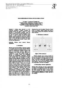
Algorithms based on RSS use radio signal attenuation properties to model the distance between nodes as a function of the received signal strength indicator (RSSI). Systems that rely on the RSSI as input parameter such as [10], [2], [1] tend to be quite accurate for short ranges if extensive post-processing is employed, but are imprecise beyond a few meters [6]. At short ranges, distance estimations exhibiting error of about 10% at the maximum range of about 20 meters [16] are feasible. The uncertainty of the radio propagation imposes problems like multipath propagation, fading and shadowing effects as well as obstacles in the line-of-sight. These effects complicate the development of a consistent model. As a result systems relying exclusively on RSSI values remain inaccurate distance estimators. Regardless of the method applied to estimate distances, the possible position of a node is represented by a circle around the beacon. Then, the intersection point of three circles, by means of a technique called trilateration, gives the node location (Fig. 1). Another localization algorithms use directional antennas and triangulation methods [7]. In [13], a combination of RSS and Bayesian inference is applied. Apart from the above techniques, there exists a collection of localization mechanisms, called range-free, in which it is not necessary to estimate distances to neighbor nodes. A simple option lies in that a node receiving the position of a neighbor, estimates its own one inside the coverage area of the neighbor. Additionally, the intersection of different coverage areas contributes to reduce the potential area where the device may be located. Obviously, a realistic approach consists in representing the coverage area by using a circle. However, the drawback of this option is that the result of intersecting two circles is not a regular geometric shape, increasing the complexity of the data structure used to represent it. One example is shown in Fig. 2. An alternative is the Bounding-Box algorithm [14], in which that circular area is represented by means of a square, getting a lighter, but more inaccurate algorithm. Next, we describe the characteristics of rectangular intersection in more detail.
Fig. 1. Trilateration. Distances to three beacons (white nodes) allow a sensor (black node) to determine its location.
158
Eva M. Garcia, Aurelio Bermudez, Rafael Casado, and Francisco J. Quiles
Fig. 2. Circular Intersection. Intersection of coverage areas of the three beacons allows a sensor to fence in the zone in where it is.
2.1 Rectangular Intersection This technique is based on the idea of connectivity. If two nodes can communicate with each other, it is assumed that one is within a square centered at the other node and with a side equal to twice the radio range. The main advantage of this algorithm is that intersecting squares is a mathematically simpler operation than intersecting circles. The reason is that when intersecting squares, the result is a rectangle (Fig. 3); however when intersecting circles, the intersection is much harder to describe mathematically. Each rectangle can be represented by its upper left and lower right corners. If all neighboring nodes have their centers at coordinates (xh yt), then the corners of the intersection rectangle can be defined by
[xLR^LR]=[m{x^R^m{y^R] The second advantage of this algorithm is that it is executed in a distributed fashion. Each node acquires positions of all its neighbors. Then, the squares centered at these neighbors are intersected yielding a final rectangle. The final position estimate is the center of the intersection rectangle. The disadvantages of this method are the dependence on the convexity of communication regions as well as the need for high connectivity to obtain a refined and accurate estimate. In the algorithm N-Hop Multilateration a phase of refinement is performed [12]. In this way, nodes without an initial estimate, due to the lack of connectivity with one beacon at least, take as reference points the estimated positions of unknown nodes in the previous phase (rectangular intersection). As a result, these nodes without connectivity estimate their position by intersecting the squares of these new reference
Wireless Sensor Network Localization using Hexagonal Intersection
o
0
159
R
• u
Fig. 3. Rectangular Intersection. Beacons know their exact position. The central node estimates its positionfromintersection of squares representing beacons range. points, and send out new information to neighboring nodes. This process is executed in an iterative fashion until a priori established tolerance value is reached. One further step is taken in [4]. Nodes having a location estimate do not send a pair of coordinates (xy), but the upper left and lower right corners of the rectangle Q delimiting its location estimate. When a node receives information from its neighboring nodes, it updates its location using the next formula:
Q->Qf) [*L -s,*L +s]*[ykmin -s,*L +s] fceK1-
J
L
J
where K is the set of nodes that sense that one performing the location update, S is the sensing range (R was the communication range), and *min>*max>.);min anc* .yLx S*ve the coordinates of the bounding box for the position of the Uh node.
3 Hexagonal Intersection As we have seen, localization techniques based on rectangular intersection present the advantage of requiring minimum computational capacity at the nodes of the network. However, it is obvious that the error introduced in estimates is greater than using circular range areas. Given that the areas of the circle and the square are ^circle ^square
~
n V
~ V
/
then the initial assumption of approximating a circular area by means of the square containing it, involves increasing the working area in a 27.3%. An intermediate approach with regard to the obtained error and the complexity of the computations may consist in representing coverage areas by using hexagons. In particular, we start from the regular hexagon centered at the circular range and whose apothem is equal to the radio range (Fig. 4). Bearing in mind that the areas of the circle and the hexagon fit the next formulas:
160
Eva M. Garcia, Aurelio Bermudez, Rafael Casado, and Francisco J. Quiles
5
4
Fig. 4. Range approximation by hexagon. ^circle
~
hexagon
U r
6rf_ 'V3
then, the use of this geometric shape implies an increase of a 10.2% in the localization area. Although the result of intersecting rectangular areas in an iterative fashion is always a new rectangle, intersecting hexagonal areas will result in irregular polygons with 6, 5, 4, or even 3 sides (Fig. 5). However, these polygons have the property of that each side has a slope of 0°, 60° or 120°. Although they have not necessary six sides, from now on we call these polygons pseudo-hexagons. If a rectangle is determined by the coordinates of two opposite vertices, a pseudohexagon can be defined by means of three vertices belonging to different sides. If we number vertices in clockwise, starting with the upper left vertex, we have considered vertices 1, 3, and 5 (Fig. 4). Conceptually, intersection of rectangles and intersection of pseudo-hexagons are very similar. Intersection of two rectangles A and B consists in comparing each side
Fig. 5. Hexagonal Intersection.
Wireless Sensor Network Localization using Hexagonal Intersection
161
of A with the corresponding side of B, and choosing those being closer to the center. After that, the computation of the four cut points of the lines defining the selected sides is performed. The intersection of pseudo-hexagons is carried out in the same way; however, in this case, it is necessary to compare six pairs of sides (instead of four) and to obtain nine cut points. The main difference between rectangular and hexagonal intersection is not the geometric shape itself, but the fact that the sides are or not parallel to the coordinates axes, because this implies that the computation of cut points is implicit in the case of rectangles. In an analogous way to rectangular intersection, in order to obtain the intersection of two pseudo-hexagons, we just have to calculate vertices 1, 3, and 5 of the resulting area.
4 Performance Evaluation To evaluate our proposal, we compare it with the improved rectangular intersection algorithm [4], described in section 2.1. Remember that in this algorithm network nodes send out the two corners determining the rectangle obtained by intersecting the rectangular areas received from other nodes. 4.1 Simulation Methodology The simulation tool has been implemented in Adobe Flash 8. Fig. 6 shows the aspect of the user interface. The simulator gets the necessary parameters for each execution from a database, which stores simulation results as well. We have carried out extensive numerical configurations, executing 100 simulations
ft
,